Location
Latitude: |
32-38-43.8820N (32.645523) |
Longitude: |
081-35-47.8020W (-81.596612) |
Elevation: |
190.3 feet MSL (58 m MSL) |
Magnetic Variation: |
7.2 W (as of April 2024 from WMM2020 model) |
Time Zone: |
UTC -5.0 (Standard Time) UTC -4.0 (Daylight Savings Time) |
From City: |
07 N.M. S of Sylvania, Georgia |
Found On: |
Atlanta Chart |
FAA Region: |
ASO |
Contacts
Manager: |
Publicly owned: |
| HANK MAIERHOFFER 538 BEACON ROAD SYLVANIA, GA 30467 912-857-3220 |
SYLVANIA SCREVEN ARPT AUTH 104 EAST TELEPHONE STREET SYLVANIA, GA 30467 912-8573328 |
Operations
Airport Status: |
Operational |
Facility Use: |
Public |
Type: |
Airport |
Activation Date: |
05/1943 |
Control tower: |
No |
Attendance (Months/Days/Hours): |
Months/Days/Hours ALL/ALL/0800-1700 |
Boundary ARTCC: |
ZJX (Jacksonville) |
Responsible ARTCC: |
ZJX (Jacksonville) |
Lighting Schedule: |
SEE RMK |
Segmented Circle Indicator: |
Yes |
Traffic Pattern Altitude (MSL): |
1190 feet (363 m) |
NOTAMs Facility: |
MCN |
NOTAM-D Service: |
Yes |
International Airport of Entry: |
No |
Customs Landing Rights: |
No |
Military Landing Rights: |
Yes |
Civil/Military Joint Use: |
No |
Based Aircraft
| Single Engine: | 28 |
| Multi Engine: | 3 |
Annual Operations (as of 12/31/2022)
| Total Operations: | 18000 | |
| GA Local: | 10000 | 55.6% |
| GA Itinerant: | 7000 | 38.9% |
| Military Aircraft: | 1000 | 5.6% |
Communications
| CTAF: | 122.800 |
| Unicom: | 122.800 |
| AWOS-3: | 118.875 (912-857-9000) |
- APCH/DEP SVC PRVDD BY JACKSONVILLE ARTCC ON FREQS 132.925/363.2 (MILLEN RCAG).
Fixed Based Operators (FBOs) & Fuel
(Click on a business for detail)
Please help us keep this information up to date. This is a FREE SERVICE just like everything else on Airport Guide! If you see that a business needs to be added, modified, or deleted please fill out our Update Form.
To add, modify, or delete a business click here.
Please help us keep this information up to date. This is a FREE SERVICE just like everything else on Airport Guide! If you see that a business needs to be added, modified, or deleted please fill out our Update Form.
Area Code: 912 |
| Business Name | Frequency | Phone | Fuel Grade |
|---|---|---|---|
| Aeroborne Enterprises
Update FBO info |
857-3220 | 100LL |
Flight Service Stations
| Primary | Alternate | |
| FSS on Field: | N | |
| FSS Name (ID): | Macon(MCN) | |
| Frequency: | ||
| Toll Free Phone: | 1-800-WX-BRIEF |
Instrument Procedures / Charts
FAA Terminal Procedures valid from 0901Z 03/21/24 to 0901Z 04/18/24.
There are various types of charts available for an airport. They are listed in the Page Type column. Here is a legend for those types:
APD - Airport Diagram
DP - Departure Procedure Charts
HOT - Hot Spots
IAP - Instrument Approach Procedure Charts
MIN - Minimums
STAR - Standard Terminal Arrival Charts
| Page Type | Page Name | Volume | Action Since Last Cycle |
|---|---|---|---|
| IAP | RNAV (GPS) RWY 05 | SE-4 | |
| IAP | RNAV (GPS) RWY 23 | SE-4 | |
| MIN | ALTERNATE MINIMUMS | SE-4 | |
| MIN | TAKEOFF MINIMUMS | SE-4 |
Terminal Procedures are only available for airports in several countries with more being added all the time. If you are looking for a specific country's charts, please send an email to support(at)airportguide.com stating the country name. This will be used to prioritize the implementation.
Navigation Aids (Navaids) near KJYL
| Dist (NM) | ID | Morse Code | Name | Type | Freq | True Hdg | Mag Hdg |
|---|---|---|---|---|---|---|---|
| 0.2 | JYL | . _ _ _ _ . _ _ . _ . . | Sylvania | NDB | 245 | 27 | 34 |
| 14.2 | BZ | _ . . . _ _ . . | Bullo | NDB | 407 | 193 | 200 |
| 23.9 | LNH | . _ . . _ . . . . . | Millen | NDB | 205 | 308 | 315 |
| 26.8 | ALD | . _ . _ . . _ . . | Allendale | VOR | 116.70 | 34 | 41 |
| 30.6 | CWV | _ . _ . . _ _ . . . _ | Claxton | NDB | 395 | 207 | 214 |
| 33.7 | SA | . . . . _ | Mavis | NDB | 368 | 156 | 163 |
| 36.1 | SAV | . . . . _ . . . _ | Savannah | VORTAC | 115.95 | 145 | 152 |
| 37.0 | SAV | . . . . _ . . . _ | Savannah Travis Fld | VOT | 111.00 | 147 | 154 |
| 42.3 | AG | . _ _ _ . | Bushe | NDB | 233 | 335 | 342 |
| 43.3 | EEX | . . _ . . _ | Emanuel County | NDB | 309 | 271 | 278 |
| 43.6 | UQN | . . _ _ _ . _ _ . | Onyun | NDB | 372 | 234 | 241 |
| 44.5 | SVN | . . . . . . _ _ . | Hunter | VOR-DME | 111.60 | 148 | 155 |
| 45.1 | RVJ | . _ . . . . _ . _ _ _ | Prison | NDB | 424 | 218 | 225 |
| 45.6 | NBC | _ . _ . . . _ . _ . | Beaufort | TACAN | 110.50 | 102 | 109 |
| 49.1 | MOQ | _ _ _ _ _ _ _ . _ | Mc Intosh | NDB | 263 | 174 | 181 |
| 49.4 | SV | . . . . . . _ | Wassa | NDB | 335 | 141 | 148 |
| 51.1 | RBW | . _ . _ . . . . _ _ | Walterboro | NDB | 221 | 70 | 78 |
| 53.0 | EMR | . _ _ . _ . | Emory | NDB | 385 | 337 | 344 |
| 60.5 | AIK | . _ . . _ . _ | Aiken | NDB | 347 | 356 | 363 |
| 61.2 | EDS | . _ . . . . . | Edisto | VOR-DME | 111.40 | 37 | 44 |
Nearby Airports with Fuel
Notices to Airmen (NOTAMS)
Remarks
| A110-1 | DEER ON & INVOF ARPT. |
| A110-2 | FOR CD CTC JACKSONVILLE ARTCC AT 904-845-1592. |
| A110-3 | MIL OPN RQR 24 HR PPR AT 912-687-0653. |
| A16 | ALTN PHONE 912-682-9313. |
| A57-05 | CTLG OBSTN EXCEEDS A 45 DEG SLP. |
| A58-05 | 30 FT TREES, 300 FT RIGHT BTN RWY END AND 200 FT FM RWY END. |
| A70-FUEL-10 | 0LL FUEL 24 HR CREDIT CART SVC AVBL. |
| A81-APT | MIRL RWY 05/23 PRESET LOW INTST DUSK-0100, TO INCR INTST AND ACTVT AFTER 0100 - CTAF. PAPI RWY 05 & 23 - CTAF. |
| E111 | ARPT CONSTRUCTED PRIOR TO 1958. |
Runways
Runway Summary
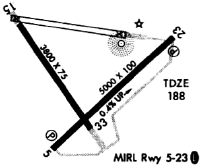
| Runways: | 05/23 15/33 |
| Longest Runway: | 05/23 is 5501 ft (1677 m) long |
| Runways with an Instrument Approach: |
KJYL Airport Runway Details
| Runway 05/23 | 5501 ft x 100 ft (1677 m x 30 m) | |
| Runway Length Source: | 3RD PARTY SURVEY as of 09/08/2019 | |
| Surface: | Asphalt - Fair condition - No special surface treatment | |
| Runway Edge Lights: | Medium Intensity | |
Runway Weight Bearing Capacity (in thousands of pounds) |
||
| Single Wheel Landing Gear: | 20.0 | |
Runway 05 |
Runway 23 |
|
Elevation: |
169.5 | 190.3 |
Latitude: |
32-38-23.8973N | 32-39-00.6856N |
Longitude: |
081-36-02.2841W | 081-35-14.8652W |
|
Runway True Alignment: |
047 | 227 |
Glide Path Angle: |
3.0 degrees | 3.0 degrees |
Traffic Pattern: |
Right | Left |
Runway Markings Type: |
Nonprecision Instrument | Nonprecision Instrument |
Runway Markings Condition: |
Good | Good |
Object at End: |
TREES | |
Object Height: |
30 | |
Distance from End: |
201 | |
Object Centerline Offset: |
300 ft. right of centerline | |
Visual Glide Slope Indicators: |
2-Light PAPI On Left Side Of Runway | 2-Light PAPI On Left Side Of Runway |
Threshold Crossing Height: |
33 | 31 |
| Runway 15/33 | 3787 ft x 75 ft (1154 m x 23 m) | |
| Runway Length Source: | 3RD PARTY SURVEY as of 09/08/2019 | |
| Surface: | Asphalt - Fair condition - No special surface treatment | |
Runway 15 |
Runway 33 |
|
Elevation: |
175.3 | 174.9 |
Latitude: |
32-39-01.6249N | 32-38-30.7576N |
Longitude: |
081-36-13.7585W | 081-35-48.6528W |
|
Runway True Alignment: |
145 | 325 |
Glide Path Angle: |
0.0 degrees | 0.0 degrees |
Traffic Pattern: |
Right | Left |
Runway Markings Type: |
Basic | Basic |
Runway Markings Condition: |
Good | Good |
Object Centerline Offset: |
300 ft. right of centerline |
Services
Airframe Repair: |
None |
Powerplant Repair: |
None |
Bottled Oxygen: |
None |
Bulk Oxygen: |
None |
Fuel Available: |
100LL |
Landing Fees: |
No |
Parking: |
Tiedowns available |
Maps & Diagrams
KJYL Sectional
Flight Planning
at skyvector.com
at skyvector.com