Location
Latitude: |
32-11-33.8000N (32.192722) |
Longitude: |
082-22-16.2000W (-82.371167) |
Elevation: |
274.3 feet MSL (84 m MSL) |
Magnetic Variation: |
6.6 W (as of April 2024 from WMM2020 model) |
Time Zone: |
UTC -5.0 (Standard Time) UTC -4.0 (Daylight Savings Time) |
From City: |
03 N.M. SE of Vidalia, Georgia |
Found On: |
Atlanta Chart |
FAA Region: |
ASO |
Contacts
Manager: |
Publicly owned: |
| BILLY RAGAN 2921 AIRPORT ROAD VIDALIA, GA 30474 912-537-3979 |
CITY OF VIDALIA CITY HALL PO BOX 280 VIDALIA, GA 30474 912-537-7661 |
Operations
Airport Status: |
Operational |
Facility Use: |
Public |
Type: |
Airport |
Activation Date: |
05/1943 |
Control tower: |
No |
Attendance (Months/Days/Hours): |
Months/Days/Hours ALL/ALL/0800-1800 |
Boundary ARTCC: |
ZJX (Jacksonville) |
Responsible ARTCC: |
ZJX (Jacksonville) |
Lighting Schedule: |
SEE RMK |
Segmented Circle Indicator: |
No |
Traffic Pattern Altitude (MSL): |
1274 feet (388 m) |
NOTAMs Facility: |
VDI |
NOTAM-D Service: |
Yes |
International Airport of Entry: |
No |
Customs Landing Rights: |
No |
Military Landing Rights: |
Yes |
Civil/Military Joint Use: |
No |
Based Aircraft
| Single Engine: | 22 |
| Multi Engine: | 3 |
Annual Operations (as of 12/31/2022)
| Total Operations: | 19100 | |
| GA Local: | 12600 | 66.0% |
| GA Itinerant: | 5000 | 26.2% |
| Military Aircraft: | 1500 | 7.9% |
Communications
| CTAF: | 122.800 |
| Unicom: | 122.800 |
| AWOS-3: | 119.925 (912-538-0219) |
- APCH/DEP SVC PRVDD BY JACKSONVILLE ARTCC ON FREQS 127.575/269.025 (ALMA RCAG).
Fixed Based Operators (FBOs) & Fuel
(Click on a business for detail)
Please help us keep this information up to date. This is a FREE SERVICE just like everything else on Airport Guide! If you see that a business needs to be added, modified, or deleted please fill out our Update Form.
To add, modify, or delete a business click here.
Please help us keep this information up to date. This is a FREE SERVICE just like everything else on Airport Guide! If you see that a business needs to be added, modified, or deleted please fill out our Update Form.
Area Code: 912 |
| Business Name | Frequency | Phone | Fuel Grade |
|---|---|---|---|
| Skyways, Inc.
Update FBO info |
Unicom 122.8 | 537-3979 | 100LL, Jet A |
Flight Service Stations
| Primary | Alternate | |
| FSS on Field: | N | |
| FSS Name (ID): | Macon(MCN) | |
| Frequency: | ||
| Toll Free Phone: | 1-800-WX-BRIEF |
Instrument Procedures / Charts
FAA Terminal Procedures valid from 0901Z 03/21/24 to 0901Z 04/18/24.
There are various types of charts available for an airport. They are listed in the Page Type column. Here is a legend for those types:
APD - Airport Diagram
DP - Departure Procedure Charts
HOT - Hot Spots
IAP - Instrument Approach Procedure Charts
MIN - Minimums
STAR - Standard Terminal Arrival Charts
| Page Type | Page Name | Volume | Action Since Last Cycle |
|---|---|---|---|
| IAP | ILS OR LOC RWY 25 | SE-4 | |
| IAP | RNAV (GPS) RWY 07 | SE-4 | |
| IAP | RNAV (GPS) RWY 25 | SE-4 | |
| MIN | ALTERNATE MINIMUMS | SE-4 | |
| MIN | TAKEOFF MINIMUMS | SE-4 |
Terminal Procedures are only available for airports in several countries with more being added all the time. If you are looking for a specific country's charts, please send an email to support(at)airportguide.com stating the country name. This will be used to prioritize the implementation.
Navigation Aids (Navaids) near VDI
| Dist (NM) | ID | Morse Code | Name | Type | Freq | True Hdg | Mag Hdg |
|---|---|---|---|---|---|---|---|
| 4.2 | UQN | . . _ _ _ . _ _ . | Onyun | NDB | 372 | 63 | 70 |
| 13.8 | RVJ | . _ . . . . _ . _ _ _ | Prison | NDB | 424 | 126 | 133 |
| 23.5 | AZE | . _ _ _ . . . | Hazlehurst | NDB | 414 | 216 | 223 |
| 25.2 | CWV | _ . _ . . _ _ . . . _ | Claxton | NDB | 395 | 89 | 96 |
| 26.6 | MQW | _ _ _ _ . _ . _ _ | Mc Rae | NDB | 280 | 257 | 263 |
| 28.7 | EEX | . . _ . . _ | Emanuel County | NDB | 309 | 351 | 358 |
| 28.9 | BHC | _ . . . . . . . _ . _ . | Baxley | NDB | 376 | 181 | 188 |
| 32.2 | DBN | _ . . _ . . . _ . | Dublin | VORTAC | 113.10 | 313 | 320 |
| 36.8 | DB | _ . . _ . . . | Creke | NDB | 251 | 298 | 304 |
| 38.3 | BZ | _ . . . _ _ . . | Bullo | NDB | 407 | 69 | 76 |
| 39.9 | EZM | . _ _ . . _ _ | Eastman | NDB | 366 | 264 | 270 |
| 40.0 | AMG | . _ _ _ _ _ . | Alma | VORTAC | 115.10 | 190 | 197 |
| 45.7 | JES | . _ _ _ . . . . | Slover | NDB | 340 | 147 | 154 |
| 46.8 | LNH | . _ . . _ . . . . . | Millen | NDB | 205 | 25 | 32 |
| 47.9 | JYL | . _ _ _ _ . _ _ . _ . . | Sylvania | NDB | 245 | 54 | 61 |
| 48.9 | MOQ | _ _ _ _ _ _ _ . _ | Mc Intosh | NDB | 263 | 116 | 123 |
| 52.0 | AY | . _ _ . _ _ | Wiket | NDB | 219 | 181 | 188 |
| 52.9 | SA | . . . . _ | Mavis | NDB | 368 | 93 | 100 |
| 55.0 | OWC | _ _ _ . _ _ _ . _ . | Coffee County | NDB | 390 | 210 | 216 |
| 56.2 | AYS | . _ _ . _ _ . . . | Waycross | VORTAC | 110.20 | 189 | 196 |
Nearby Airports with Fuel
Notices to Airmen (NOTAMS)
Remarks
| A110-2 | FOR CD CTC JACKSONVILLE ARTCC AT 904-845-1592. |
| A70-FUEL-10 | 0LL FUEL 24 HR CREDIT CARD SVC AVBL. |
| A81-APT | HIRL RWY 07/25 PRESET MED INTS DUSK-2300. AFTER 2300 ACTVT - CTAF. ACTVT MALSR RWY 25; REIL RWY 07 - CTAF. PAPI RWY 07 & 25 OPR CONSLY. |
Runways
Runway Summary
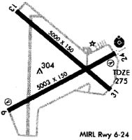
| Runways: | 07/25 14/32 |
| Longest Runway: | 07/25 is 6002 ft (1829 m) long |
| Runways with an Instrument Approach: | 25 |
VDI Airport Runway Details
| Runway 07/25 | 6002 ft x 100 ft (1829 m x 30 m) | |
| Runway Length Source: | 3RD PARTY SURVEY as of 12/19/2011 | |
| Surface: | Concrete - Good condition - No special surface treatment | |
| Runway Edge Lights: | High Intensity | |
Runway Weight Bearing Capacity (in thousands of pounds) |
||
| Single Wheel Landing Gear: | 30.0 | |
| Dual Wheel Landing Gear: | 48.0 | |
| Dual Tandem Wheel Landing Gear: | 85.0 | |
Runway 07 |
Runway 25 |
|
Elevation: |
272.4 | 268.9 |
Latitude: |
32-11-15.4146N | 32-11-42.5743N |
Longitude: |
082-22-45.3190W | 082-21-43.2019W |
|
Runway True Alignment: |
063 | 243 |
ILS Type: |
ILS | |
Glide Path Angle: |
3.0 degrees | 3.0 degrees |
Traffic Pattern: |
Left | Left |
Runway Markings Type: |
Precision Instrument | Precision Instrument |
Runway Markings Condition: |
Fair | Fair |
Object at End: |
TREES | |
Object Height: |
20 | |
Distance from End: |
505 | |
Object Centerline Offset: |
284 ft. right of centerline | |
Visual Glide Slope Indicators: |
4-Light PAPI On Left Side Of Runway | 4-Light PAPI On Left Side Of Runway |
Approach Light System: |
1,400 Foot Medium Intensity Approach Lighting System With Runway Alignment Indicator Lights | |
REIL: |
Yes | No |
Threshold Crossing Height: |
41 | 48 |
| Runway 14/32 | 5002 ft x 75 ft (1525 m x 23 m) | |
| Runway Length Source: | 3RD PARTY SURVEY as of 12/19/2011 | |
| Surface: | Concrete - Good condition - No special surface treatment | |
Runway Weight Bearing Capacity (in thousands of pounds) |
||
| Single Wheel Landing Gear: | 30.0 | |
| Dual Wheel Landing Gear: | 48.0 | |
| Dual Tandem Wheel Landing Gear: | 85.0 | |
Runway 14 |
Runway 32 |
|
Elevation: |
271.7 | 272.1 |
Latitude: |
32-11-56.0334N | 32-11-23.1645N |
Longitude: |
082-22-40.2519W | 082-21-56.7364W |
|
Runway True Alignment: |
132 | 312 |
Glide Path Angle: |
0.0 degrees | 0.0 degrees |
Traffic Pattern: |
Left | Left |
Runway Markings Type: |
Nonprecision Instrument | Nonprecision Instrument |
Runway Markings Condition: |
Good | Good |
Object at End: |
TREES | TREES |
Object Height: |
25 | 22 |
Distance from End: |
309 | 590 |
Object Centerline Offset: |
284 ft. right of centerline |
Services
Airframe Repair: |
Major |
Powerplant Repair: |
Major |
Bottled Oxygen: |
None |
Bulk Oxygen: |
None |
Fuel Available: |
100LL, Jet A+ |
Landing Fees: |
No |
Parking: |
Hangars and tiedowns available |
Maps & Diagrams
VDI Sectional
Flight Planning
at skyvector.com
at skyvector.com