Location
Latitude: |
32-36-32.9000N (32.609139) |
Longitude: |
082-22-11.8000W (-82.369944) |
Elevation: |
327.2 feet MSL (100 m MSL) |
Magnetic Variation: |
6.7 W (as of April 2024 from WMM2020 model) |
Time Zone: |
UTC -5.0 (Standard Time) UTC -4.0 (Daylight Savings Time) |
From City: |
02 N.M. NW of Swainsboro, Georgia |
Found On: |
Atlanta Chart |
FAA Region: |
ASO |
Contacts
Manager: |
Publicly owned: |
| KEN WARNOCK 102 SOUTH MAIN STREET SWAINSBORO, GA 30401 478-237-5882 |
CITY OF SWAINSBORO 101 WEST MAIN STREET SWAINSBORO, GA 30401 478-237-7025 |
Operations
Airport Status: |
Operational |
Facility Use: |
Public |
Type: |
Airport |
Activation Date: |
06/1942 |
Control tower: |
No |
Attendance (Months/Days/Hours): |
Months/Days/Hours ALL/MON-SAT/0800-1700 |
Boundary ARTCC: |
ZTL (Atlanta) |
Responsible ARTCC: |
ZTL (Atlanta) |
Lighting Schedule: |
SEE RMK |
Segmented Circle Indicator: |
Yes |
Traffic Pattern Altitude (MSL): |
1327 feet (404 m) |
NOTAMs Facility: |
MCN |
NOTAM-D Service: |
Yes |
International Airport of Entry: |
No |
Customs Landing Rights: |
No |
Military Landing Rights: |
Yes |
Civil/Military Joint Use: |
No |
Based Aircraft
| Single Engine: | 5 |
| Multi Engine: | 5 |
| Jet Engine: | 3 |
| Gliders: | 1 |
Annual Operations (as of 12/31/2022)
| Total Operations: | 10500 | |
| Air Taxi: | 1000 | 9.5% |
| GA Local: | 3500 | 33.3% |
| GA Itinerant: | 6000 | 57.1% |
Communications
| CTAF: | 122.975 |
| Unicom: | 122.975 |
| AWOS-3: | 133.375 (478-237-8437) |
- APCH/DEP SVC PRVDD BY ATLANTA ARTCC ON FREQS 127.95/343.75 (MILLEN RCAG).
Fixed Based Operators (FBOs) & Fuel
(Click on a business for detail)
Please help us keep this information up to date. This is a FREE SERVICE just like everything else on Airport Guide! If you see that a business needs to be added, modified, or deleted please fill out our Update Form.
To add, modify, or delete a business click here.
Please help us keep this information up to date. This is a FREE SERVICE just like everything else on Airport Guide! If you see that a business needs to be added, modified, or deleted please fill out our Update Form.
Area Code: 478 |
| Business Name | Frequency | Phone | Fuel Grade |
|---|---|---|---|
| Hacienda De Gay Aviation
Update FBO info |
Unicom 122.8 | 237-7281 | 100LL, Jet A |
Flight Service Stations
| Primary | Alternate | |
| FSS on Field: | N | |
| FSS Name (ID): | Macon(MCN) | |
| Frequency: | ||
| Toll Free Phone: | 1-800-WX-BRIEF |
Instrument Procedures / Charts
FAA Terminal Procedures valid from 0901Z 03/21/24 to 0901Z 04/18/24.
There are various types of charts available for an airport. They are listed in the Page Type column. Here is a legend for those types:
APD - Airport Diagram
DP - Departure Procedure Charts
HOT - Hot Spots
IAP - Instrument Approach Procedure Charts
MIN - Minimums
STAR - Standard Terminal Arrival Charts
| Page Type | Page Name | Volume | Action Since Last Cycle |
|---|---|---|---|
| IAP | ILS OR LOC RWY 14 | SE-4 | |
| IAP | RNAV (GPS) RWY 14 | SE-4 | |
| IAP | RNAV (GPS) RWY 32 | SE-4 | |
| MIN | ALTERNATE MINIMUMS | SE-4 | |
| MIN | TAKEOFF MINIMUMS | SE-4 |
Terminal Procedures are only available for airports in several countries with more being added all the time. If you are looking for a specific country's charts, please send an email to support(at)airportguide.com stating the country name. This will be used to prioritize the implementation.
Navigation Aids (Navaids) near KSBO
| Dist (NM) | ID | Morse Code | Name | Type | Freq | True Hdg | Mag Hdg |
|---|---|---|---|---|---|---|---|
| 5.4 | EEX | . . _ . . _ | Emanuel County | NDB | 309 | 309 | 316 |
| 23.4 | UQN | . . _ _ _ . _ _ . | Onyun | NDB | 372 | 170 | 177 |
| 23.4 | DBN | _ . . _ . . . _ . | Dublin | VORTAC | 113.10 | 263 | 270 |
| 26.6 | LNH | . _ . . _ . . . . . | Millen | NDB | 205 | 49 | 56 |
| 33.3 | DB | _ . . _ . . . | Creke | NDB | 251 | 257 | 264 |
| 34.9 | RVJ | . _ . . . . _ . _ _ _ | Prison | NDB | 424 | 161 | 168 |
| 35.4 | CWV | _ . _ . . _ _ . . . _ | Claxton | NDB | 395 | 134 | 141 |
| 37.6 | BZ | _ . . . _ _ . . | Bullo | NDB | 407 | 107 | 114 |
| 37.7 | HIT | . . . . . . _ | Kaolin | NDB | 360 | 310 | 317 |
| 39.3 | JYL | . _ _ _ _ . _ _ . _ . . | Sylvania | NDB | 245 | 86 | 93 |
| 40.3 | MQW | _ _ _ _ . _ . _ _ | Mc Rae | NDB | 280 | 220 | 227 |
| 45.9 | AG | . _ _ _ . | Bushe | NDB | 233 | 27 | 34 |
| 46.0 | AZE | . _ _ _ . . . | Hazlehurst | NDB | 414 | 197 | 204 |
| 49.0 | EZM | . _ _ . . _ _ | Eastman | NDB | 366 | 234 | 240 |
| 51.4 | UMB | . . _ _ _ _ . . . | Culvr | NDB | 380 | 309 | 315 |
| 53.8 | BHC | _ . . . . . . . _ . _ . | Baxley | NDB | 376 | 181 | 188 |
| 54.5 | EMR | . _ _ . _ . | Emory | NDB | 385 | 20 | 27 |
| 56.8 | AA | . _ . _ | Cedar | NDB | 341 | 347 | 354 |
| 59.5 | ALD | . _ . _ . . _ . . | Allendale | VOR | 116.70 | 65 | 72 |
| 60.0 | SA | . . . . _ | Mavis | NDB | 368 | 118 | 125 |
Nearby Airports with Fuel
Notices to Airmen (NOTAMS)
Remarks
| A110-3 | DEER ON & INVOF ARPT. |
| A110-4 | GEESE ON AND INVOF ARPT. |
| A110-5 | FOR CD CTC ATLANTA ARTCC AT 770-210-7692. |
| A17 | AFT HRS & SUNDAY PHONE 803-530-3124. |
| A24 | ONLY CHARGE FOR PART 135 OPS. |
| A58-32 | 6 FT FENCE AND VEHICLES LOCATED 400 FT RIGHT 0-200 FT FROM THR. |
| A70-FUEL-10 | 0LL FUEL IS SELF SERVICE AFTER HRS. |
| A81-APT | ACTVT PAPI RWY 14; HIRL RWY 14/32 - CTAF. |
| E111 | EXISTED PRIOR TO 1959. |
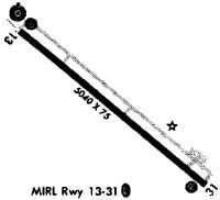
Runways
Runway Summary
| Runways: | 14/32 |
| Longest Runway: | 14/32 is 6021 ft (1835 m) long |
| Runways with an Instrument Approach: | 14 |
KSBO Airport Runway Details
| Runway 14/32 | 6021 ft x 100 ft (1835 m x 30 m) | |
| Runway Length Source: | 3RD PARTY SURVEY as of 01/19/2006 | |
| Surface: | Asphalt - Good condition - No special surface treatment | |
| Runway Edge Lights: | High Intensity | |
Runway Weight Bearing Capacity (in thousands of pounds) |
||
| Single Wheel Landing Gear: | 45.0 | |
| Dual Wheel Landing Gear: | 65.0 | |
| Dual Tandem Wheel Landing Gear: | 120.0 | |
Runway 14 |
Runway 32 |
|
Elevation: |
324.0 | 322.0 |
Latitude: |
32-36-51.8231N | 32-36-13.9286N |
Longitude: |
082-22-38.9454W | 082-21-44.6343W |
|
Runway True Alignment: |
129 | 309 |
ILS Type: |
ILS/DME | |
Glide Path Angle: |
3.0 degrees | 0.0 degrees |
Traffic Pattern: |
Left | Left |
Runway Markings Type: |
Precision Instrument | Nonprecision Instrument |
Runway Markings Condition: |
Fair | Fair |
Object at End: |
TREES | BLDG |
Object Height: |
6 | 5 |
Object Marked/Lighted?: |
Lighted | |
Distance from End: |
269 | 226 |
Object Centerline Offset: |
506 ft. left of centerline | 468 ft. right of centerline |
Visual Glide Slope Indicators: |
4-Light PAPI On Left Side Of Runway | |
Threshold Crossing Height: |
45 |
Services
Airframe Repair: |
Minor |
Powerplant Repair: |
Minor |
Bottled Oxygen: |
None |
Bulk Oxygen: |
None |
Fuel Available: |
100LL, Jet A |
Landing Fees: |
No |
Parking: |
Hangars and tiedowns available |
Maps & Diagrams
KSBO Sectional
Flight Planning
at skyvector.com
at skyvector.com