Location
Latitude: |
37-41-38.1000N (37.693917) |
Longitude: |
097-12-53.7000W (-97.214917) |
Elevation: |
1408.6 feet MSL (429 m MSL) |
Magnetic Variation: |
3 E (as of April 2024 from WMM2020 model) |
Time Zone: |
UTC -6.0 (Standard Time) UTC -5.0 (Daylight Savings Time) |
From City: |
05 N.M. E of Wichita, Kansas |
Found On: |
Wichita Chart |
FAA Region: |
ACE |
Contacts
Manager: |
Privately owned: |
| TODD BAYLESS 10511 E. CENTRAL WICHITA, KS 67201 (316) 515-8365 |
BEECHCRAFT AIRCRAFT COMPANY 10511 E. CENTRAL WICHITA, KS 67201 (316) 515-5300 |
Operations
Airport Status: |
Operational |
Facility Use: |
Public |
Type: |
Airport |
Activation Date: |
04/1940 |
Control tower: |
Yes |
Attendance (Months/Days/Hours): |
Months/Days/Hours ALL/MON-FRI/0700-1730 |
Boundary ARTCC: |
ZKC (Kansas City) |
Responsible ARTCC: |
ZKC (Kansas City) |
Lighting Schedule: |
SEE RMK |
Segmented Circle Indicator: |
Yes |
Traffic Pattern Altitude (MSL): |
2409 feet (734 m) |
NOTAMs Facility: |
ICT |
NOTAM-D Service: |
Yes |
Based Aircraft
| Single Engine: | 21 |
| Multi Engine: | 29 |
| Jet Engine: | 10 |
| Military Aircraft: | 17 |
Annual Operations (as of 08/13/2019)
| Total Operations: | 32700 | |
| GA Local: | 26500 | 81.0% |
| GA Itinerant: | 1700 | 5.2% |
| Military Aircraft: | 4500 | 13.8% |
Communications
| CTAF: | 126.800 |
| Unicom: | 122.950 |
| Tower: | BEECH 126.8 313.6 Hrs: 0700-1730 MON-FRI |
| Clearance Del.: | 125.0 ;WHEN TWR CLSD 125.0 ;WHEN TWR CLSD 125.0 ;WHEN TWR CLSD |
| Ground: | 121.7 |
| Approach: | WICHITA |
| Departure: | WICHITA |
| AWOS-3PT: | 119.45 (316-515-7116) |
| EMERG: | 121.5 |
- ATCT OWNED/OPERATED BY BEECHCRAFT CORP.
- OTHER TIMES BY NOTAM; CHECK WITH FLT SVS OR WICHITA APCH CTL ON FREQ 134.8.
Fixed Based Operators (FBOs) & Fuel
(Click on a business for detail)
Please help us keep this information up to date. This is a FREE SERVICE just like everything else on Airport Guide! If you see that a business needs to be added, modified, or deleted please fill out our Update Form.
To add, modify, or delete a business click here.
Please help us keep this information up to date. This is a FREE SERVICE just like everything else on Airport Guide! If you see that a business needs to be added, modified, or deleted please fill out our Update Form.
Area Code: 316 |
| Business Name | Frequency | Phone | Fuel Grade |
|---|---|---|---|
| FlightSafety International Raytheon Learning Center
Website Update FBO info |
685-4949, 800-488-3747 | ||
| FlightSafety International Raytheon Maint. Learning Center
Website Update FBO info |
685-5510 |
Flight Service Stations
| Primary | Alternate | |
| FSS on Field: | N | |
| FSS Name (ID): | Wichita(ICT) | |
| Frequency: | ||
| Toll Free Phone: | 1-800-WX-BRIEF |
Instrument Procedures / Charts
FAA Terminal Procedures valid from 0901Z 03/21/24 to 0901Z 04/18/24.
There are various types of charts available for an airport. They are listed in the Page Type column. Here is a legend for those types:
APD - Airport Diagram
DP - Departure Procedure Charts
HOT - Hot Spots
IAP - Instrument Approach Procedure Charts
MIN - Minimums
STAR - Standard Terminal Arrival Charts
| Page Type | Page Name | Volume | Action Since Last Cycle |
|---|---|---|---|
| APD | AIRPORT DIAGRAM | NC-2 | |
| IAP | RNAV (GPS) RWY 01 | NC-2 | |
| IAP | RNAV (GPS) RWY 19 | NC-2 | |
| IAP | VOR-B | NC-2 | |
| MIN | TAKEOFF MINIMUMS | NC-2 |
Terminal Procedures are only available for airports in several countries with more being added all the time. If you are looking for a specific country's charts, please send an email to support(at)airportguide.com stating the country name. This will be used to prioritize the implementation.
Navigation Aids (Navaids) near BEC
| Dist (NM) | ID | Morse Code | Name | Type | Freq | True Hdg | Mag Hdg |
|---|---|---|---|---|---|---|---|
| 5.0 | IAB | . . . _ _ . . . | Mc Connell | TACAN | 116.50 | 210 | 207 |
| 10.9 | ICT | . . _ . _ . _ | Wichita | VOT | 114.00 | 251 | 248 |
| 13.4 | IC | . . _ . _ . | Piche | NDB | 332 | 238 | 235 |
| 17.8 | ICT | . . _ . _ . _ | Wichita | VORTAC | 113.80 | 280 | 277 |
| 22.4 | EWK | . . _ _ _ . _ | Newton | NDB | 281 | 352 | 349 |
| 23.7 | EGT | . _ _ . _ | Wellington | NDB | 414 | 200 | 197 |
| 27.2 | CA | _ . _ . . _ | Harvs | NDB | 395 | 353 | 350 |
| 37.2 | SO | . . . _ _ _ | Sawcy | NDB | 353 | 166 | 163 |
| 38.6 | HUT | . . . . . . _ _ | Hutchinson | VOR-DME | 116.80 | 298 | 295 |
| 42.4 | HU | . . . . . . _ | Saltt | NDB | 404 | 307 | 304 |
| 45.2 | MPR | _ _ . _ _ . . _ . | Mc Pherson | NDB | 227 | 330 | 327 |
| 52.4 | PN | . _ _ . _ . | Ponca | NDB | 515 | 173 | 170 |
| 55.7 | ANY | . _ _ . _ . _ _ | Anthony | TACAN | 112.90 | 235 | 232 |
| 56.9 | PER | . _ _ . . . _ . | Pioneer | VORTAC | 113.20 | 177 | 174 |
| 61.8 | LYO | . _ . . _ . _ _ _ _ _ | Lyons | NDB | 386 | 309 | 306 |
| 62.3 | EMP | . _ _ . _ _ . | Emporia | VORTAC | 112.80 | 54 | 51 |
| 62.6 | SL | . . . . _ . . | Flory | NDB | 344 | 341 | 338 |
| 62.9 | HRU | . . . . . _ . . . _ | Herington | NDB | 407 | 17 | 14 |
| 72.8 | PTT | . _ _ . _ _ | Pratt | NDB | 356 | 271 | 268 |
| 76.3 | SLN | . . . . _ . . _ . | Salina | VORTAC | 117.10 | 345 | 342 |
Nearby Airports with Fuel
Notices to Airmen (NOTAMS)
Remarks
| A110-1 | ARR & DEP ACFT MAINTAIN 2200 FT MSL WITHIN 5 MILES OF FIELD DUE TO AFB TRAFFIC. |
| A110-10 | PRKG UNAVBL EXC 4 HRS PPR CALL 316-515-7140. |
| A110-11 | EXTENSIVE TRAINING ACTIVITIES |
| A110-12 | RWY 19 CALM WIND RWY. |
| A110-2 | ARRS FROM THE W CROSS MIDFIELD ENTER DNWND. |
| A110-6 | DEER, COYOTE & MIGRATORY WATER FOWL ON & INVOF ARPT. |
| A110-7 | PPR FOR PARKING OR TAXIING WEST SIDE OF RY. |
| A110-8 | BE ALERT COL JAMES JABARA ARPT 3 MILES NORTH 1/2 MILE WEST OF ARPT. |
| A81-APT | WHEN ATCT CLSD ACTVT REIL RWY 01 AND 19; MIRL RWY 01/19 - CTAF. |
| E111 | EXISTED PRIOR TO 1959. |
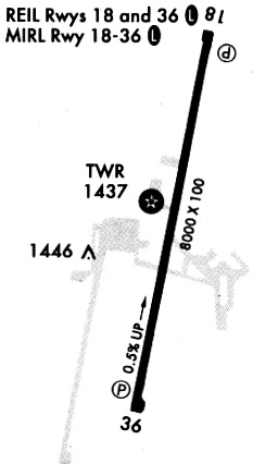
Runways
Runway Summary
| Runways: | 01/19 |
| Longest Runway: | 01/19 is 8001 ft (2439 m) long |
| Runways with an Instrument Approach: |
BEC Airport Runway Details
| Runway 01/19 | 8001 ft x 100 ft (2439 m x 30 m) | |
| Runway Length Source: | 3RD PARTY SURVEY as of 11/07/2011 | |
| Surface: | Concrete - Good condition - No special surface treatment | |
| Runway Edge Lights: | Medium Intensity | |
Runway Weight Bearing Capacity (in thousands of pounds) |
||
| Dual Wheel Landing Gear: | 75.0 | |
Runway 01 |
Runway 19 |
|
Elevation: |
1371.2 | 1408.6 |
Latitude: |
37-40-59.3489N | 37-42-16.8543N |
Longitude: |
097-13-03.6629W | 097-12-43.8106W |
|
Runway True Alignment: |
011 | 191 |
Glide Path Angle: |
3.0 degrees | 3.0 degrees |
Traffic Pattern: |
Right | Left |
Runway Markings Type: |
Nonprecision Instrument | Nonprecision Instrument |
Runway Markings Condition: |
Good | Good |
Visual Glide Slope Indicators: |
4-Light PAPI On Left Side Of Runway | 4-Light PAPI On Left Side Of Runway |
REIL: |
Yes | Yes |
Threshold Crossing Height: |
45 | 45 |
Services
Airframe Repair: |
Major |
Powerplant Repair: |
Major |
Bottled Oxygen: |
Low Pressure |
Bulk Oxygen: |
None |
Fuel Available: |
100LL, Jet A |
Landing Fees: |
No |
Parking: |
Hangars and tiedowns available |
Maps & Diagrams
BEC Sectional
Flight Planning
at skyvector.com
at skyvector.com