Location
Latitude: |
30-14-35.7000N (30.24325) |
Longitude: |
098-54-33.1000W (-98.909194) |
Elevation: |
1694.7 feet MSL (517 m MSL) |
Magnetic Variation: |
3.8 E (as of May 2024 from WMM2020 model) |
Time Zone: |
UTC -6.0 (Standard Time) UTC -5.0 (Daylight Savings Time) |
From City: |
03 N.M. SW of Fredericksburg, Texas |
Found On: |
San Antonio Chart |
FAA Region: |
ASW |
Contacts
Manager: |
Publicly owned: |
| TONY LOMBARDI 101 W MAIN UNIT 9 FREDERICKSBURG, TX 78624 830-990-5764 |
GILLESPIE COUNTY 101 W MAIN FREDERICKSBURG, TX 78624 830-997-7502 |
Operations
Airport Status: |
Operational |
Facility Use: |
Public |
Type: |
Airport |
Activation Date: |
03/1947 |
Control tower: |
No |
Attendance (Months/Days/Hours): |
Months/Days/Hours ALL/ALL/0800-1800 |
Boundary ARTCC: |
ZHU (Houston) |
Responsible ARTCC: |
ZHU (Houston) |
Lighting Schedule: |
SEE RMK |
Segmented Circle Indicator: |
Yes |
Traffic Pattern Altitude (MSL): |
2695 feet (821 m) |
NOTAMs Facility: |
T82 |
NOTAM-D Service: |
Yes |
International Airport of Entry: |
No |
Customs Landing Rights: |
No |
Military Landing Rights: |
No |
Civil/Military Joint Use: |
No |
Based Aircraft
| Single Engine: | 87 |
| Multi Engine: | 7 |
| Jet Engine: | 4 |
| GA Helicopters: | 2 |
Annual Operations (as of 06/02/2023)
| Total Operations: | 14808 | |
| GA Local: | 7300 | 49.3% |
| GA Itinerant: | 7300 | 49.3% |
| Military Aircraft: | 208 | 1.4% |
Communications
| CTAF: | 122.700 |
| Unicom: | 122.700 |
| AWOS-3: | 120.0 (830-990-2716) |
- APCH/DEP CTL SVC PRVDD BY HOUSTON ARTCC (ZHU) ON FREQS 134.2/307.3 (FREDERICKSBURG RCAG).
Fixed Based Operators (FBOs) & Fuel
(Click on a business for detail)
Please help us keep this information up to date. This is a FREE SERVICE just like everything else on Airport Guide! If you see that a business needs to be added, modified, or deleted please fill out our Update Form.
To add, modify, or delete a business click here.
Please help us keep this information up to date. This is a FREE SERVICE just like everything else on Airport Guide! If you see that a business needs to be added, modified, or deleted please fill out our Update Form.
Area Code: 830 |
| Business Name | Frequency | Phone | Fuel Grade |
|---|
Flight Service Stations
| Primary | Alternate | |
| FSS on Field: | N | |
| FSS Name (ID): | San Angelo(SJT) | |
| Frequency: | ||
| Toll Free Phone: | 1-800-WX-BRIEF |
Instrument Procedures / Charts
FAA Terminal Procedures valid from 0901Z 03/21/24 to 0901Z 04/18/24.
There are various types of charts available for an airport. They are listed in the Page Type column. Here is a legend for those types:
APD - Airport Diagram
DP - Departure Procedure Charts
HOT - Hot Spots
IAP - Instrument Approach Procedure Charts
MIN - Minimums
STAR - Standard Terminal Arrival Charts
| Page Type | Page Name | Volume | Action Since Last Cycle |
|---|---|---|---|
| IAP | RNAV (GPS) RWY 14 | SC-3 | |
| IAP | RNAV (GPS) RWY 32 | SC-3 | |
| IAP | VOR/DME-A | SC-3 | |
| MIN | ALTERNATE MINIMUMS | SC-3 | |
| MIN | TAKEOFF MINIMUMS | SC-3 |
Terminal Procedures are only available for airports in several countries with more being added all the time. If you are looking for a specific country's charts, please send an email to support(at)airportguide.com stating the country name. This will be used to prioritize the implementation.
Navigation Aids (Navaids) near T82
| Dist (NM) | ID | Morse Code | Name | Type | Freq | True Hdg | Mag Hdg |
|---|---|---|---|---|---|---|---|
| 10.8 | STV | . . . _ . . . _ | Stonewall | VORTAC | 113.80 | 101 | 97 |
| 24.9 | CSI | _ . _ . . . . . . | Center Point | VORTAC | 117.50 | 219 | 215 |
| 33.8 | LLO | . _ . . . _ . . _ _ _ | Llano | VORTAC | 108.20 | 10 | 6 |
| 42.0 | AN | . _ _ . | Alamo | NDB | 368 | 155 | 151 |
| 42.8 | SAT | . . . . _ _ | San Antonio | VORTAC | 116.80 | 146 | 142 |
| 45.8 | BMQ | _ . . . _ _ _ _ . _ | Burnet | NDB | 341 | 49 | 45 |
| 48.3 | SAT | . . . . _ _ | San Antonio | VOT | 110.40 | 151 | 147 |
| 51.6 | JCT | . _ _ _ _ . _ . _ | Junction | VORTAC | 116.00 | 294 | 290 |
| 52.7 | RU | . _ . . . _ | Garys | NDB | 272 | 108 | 104 |
| 53.9 | KSY | _ . _ . . . _ . _ _ | Kelly | TACAN | 112.00 | 161 | 157 |
| 53.9 | DHK | _ . . . . . . _ . _ | Randolph | TACAN | 109.90 | 141 | 137 |
| 54.0 | HMA | . . . . _ _ . _ | Hondo | NDB | 329 | 194 | 190 |
| 54.2 | RND | . _ . _ . _ . . | Randolph | VORTAC | 112.30 | 143 | 139 |
| 55.4 | HDO | . . . . _ . . _ _ _ | Hondo | VOR-DME | 109.40 | 194 | 190 |
| 60.0 | BBD | _ . . . _ . . . _ . . | Brady | NDB | 380 | 339 | 335 |
| 63.9 | SSF | . . . . . . . . _ . | Stinson | VOR | 108.40 | 157 | 153 |
| 64.6 | BS | _ . . . . . . | Creed | NDB | 255 | 97 | 94 |
| 66.3 | HHH | . . . . . . . . . . . . | Devine | NDB | 359 | 181 | 177 |
| 68.9 | GUO | _ _ . . . _ _ _ _ | Georgetown | NDB | 332 | 67 | 64 |
| 69.0 | AGJ | . _ _ _ . . _ _ _ | Gooch Springs | VORTAC | 112.50 | 34 | 30 |
Nearby Airports with Fuel
Notices to Airmen (NOTAMS)
Remarks
| A110-2 | 75 FT TANK 300 FT SE OF ROTG BCN. |
| A110-4 | GCO AVBL ON FREQ 121.725 THRU HOUSTON ARTCC - 6 CLICKS; FSS - 4 CLICKS. |
| A110-5 | FBO 830-997-3313. |
| A110-6 | SEASONAL FFR AIR OPNS IN AND OUT OF ARPT. |
| A110-7 | FOR CD IF UNA VIA GCO CTC HOUSTON ARTCC AT 281-230-5622. |
| A52-14 | ALSO 30 FT TREES 680 FT DSTC ACRS APCH. |
| A58-14 | RWY 14 +3 FT FENCE 190-200 FT FM THR, 216 FT RIGHT. |
| A70-FUEL-10 | 0LL FUEL 24 HR SELF SERVE. |
| A81-APT | MIRL RWY 14/32 ACTVT - CTAF (5 CLICKS - LOW INTST, 7 CLICKS - MED INTST). |
| E111 | PREDATES THE ACT. |
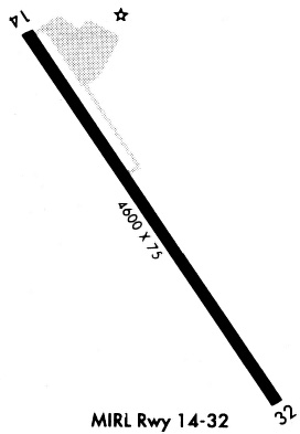
Runways
Runway Summary
| Runways: | 14/32 |
| Longest Runway: | 14/32 is 5001 ft (1524 m) long |
| Runways with an Instrument Approach: |
T82 Airport Runway Details
| Runway 14/32 | 5001 ft x 75 ft (1524 m x 23 m) | |
| Runway Length Source: | 3RD PARTY SURVEY as of 04/21/2007 | |
| Surface: | Asphalt - Good condition - No special surface treatment | |
| Runway Pavement Class: | 21 /F/C/X/T | |
| Runway Edge Lights: | Medium Intensity | |
Runway Weight Bearing Capacity (in thousands of pounds) |
||
| Single Wheel Landing Gear: | 30.0 | |
Runway 14 |
Runway 32 |
|
Elevation: |
1694.6 | 1677.1 |
Latitude: |
30-14-56.3718N | 30-14-14.9784N |
Longitude: |
098-54-48.7070W | 098-54-17.4397W |
|
Runway True Alignment: |
147 | 327 |
Glide Path Angle: |
3.0 degrees | 3.0 degrees |
Traffic Pattern: |
Right | Left |
Runway Markings Type: |
Nonprecision Instrument | Nonprecision Instrument |
Runway Markings Condition: |
Fair | Fair |
Object at End: |
FENCE | ROAD |
Object Height: |
3 | 12 |
Object Marked/Lighted?: |
Lighted | |
Distance from End: |
200 | 357 |
Object Centerline Offset: |
216 ft. right of centerline | 250 ft. right of centerline |
Visual Glide Slope Indicators: |
2-Light PAPI On Left Side Of Runway | 2-Light PAPI On Left Side Of Runway |
Threshold Crossing Height: |
43 | 37 |
Services
Airframe Repair: |
Major |
Powerplant Repair: |
Major |
Bottled Oxygen: |
None |
Bulk Oxygen: |
None |
Fuel Available: |
100LL, Jet A |
Landing Fees: |
No |
Parking: |
Tiedowns available |
Maps & Diagrams
T82 Sectional
Flight Planning
at skyvector.com
at skyvector.com