Location
Latitude: |
29-12-40.8000N (29.211333) |
Longitude: |
099-44-36.9000W (-99.743583) |
Elevation: |
941.9 feet MSL (287 m MSL) |
Magnetic Variation: |
4.3 E (as of April 2024 from WMM2020 model) |
Time Zone: |
UTC -6.0 (Standard Time) UTC -5.0 (Daylight Savings Time) |
From City: |
03 N.M. E of Uvalde, Texas |
Found On: |
San Antonio Chart |
FAA Region: |
ASW |
Contacts
Manager: |
Publicly owned: |
| JOE A. CARDENAS PO BOX 799 UVALDE, TX 78802 830-278-3315 |
CITY OF UVALDE PO BOX 799 UVALDE, TX 78802 830-278-3315 |
Operations
Airport Status: |
Operational |
Facility Use: |
Public |
Type: |
Airport |
Activation Date: |
01/1942 |
Control tower: |
No |
Attendance (Months/Days/Hours): |
Months/Days/Hours ALL/ALL/0700-1900 |
Boundary ARTCC: |
ZHU (Houston) |
Responsible ARTCC: |
ZHU (Houston) |
Lighting Schedule: |
SEE RMK |
Segmented Circle Indicator: |
Yes |
Traffic Pattern Altitude (MSL): |
1942 feet (592 m) |
NOTAMs Facility: |
UVA |
NOTAM-D Service: |
Yes |
International Airport of Entry: |
No |
Customs Landing Rights: |
No |
Military Landing Rights: |
Yes |
Civil/Military Joint Use: |
No |
Based Aircraft
| Single Engine: | 28 |
| Multi Engine: | 8 |
| Jet Engine: | 6 |
| GA Helicopters: | 1 |
| Gliders: | 2 |
Annual Operations (as of 05/28/2023)
| Total Operations: | 12565 | |
| Air Taxi: | 265 | 2.1% |
| GA Local: | 8000 | 63.7% |
| GA Itinerant: | 4000 | 31.8% |
| Military Aircraft: | 300 | 2.4% |
Communications
| CTAF: | 122.800 |
| Unicom: | 122.800 |
| AWOS-3: | 124.175 (830-278-8862) |
- APCH/DEP CTL SVC PRVDD BY HOUSTON ARTCC (ZHU) ON FREQS 134.95/269.4 (UVALDE RCAG.)
Fixed Based Operators (FBOs) & Fuel
(Click on a business for detail)
Please help us keep this information up to date. This is a FREE SERVICE just like everything else on Airport Guide! If you see that a business needs to be added, modified, or deleted please fill out our Update Form.
To add, modify, or delete a business click here.
Please help us keep this information up to date. This is a FREE SERVICE just like everything else on Airport Guide! If you see that a business needs to be added, modified, or deleted please fill out our Update Form.
Area Code: 210 |
| Business Name | Frequency | Phone | Fuel Grade |
|---|---|---|---|
| Southstar Aircraft Interiors
Update FBO info |
278-4108 | ||
| Uvalde Flight Center
Update FBO info |
278-4481 | 100LL, Jet A |
Flight Service Stations
| Primary | Alternate | |
| FSS on Field: | N | |
| FSS Name (ID): | San Angelo(SJT) | |
| Frequency: | ||
| Toll Free Phone: | 1-800-WX-BRIEF |
Instrument Procedures / Charts
FAA Terminal Procedures valid from 0901Z 03/21/24 to 0901Z 04/18/24.
There are various types of charts available for an airport. They are listed in the Page Type column. Here is a legend for those types:
APD - Airport Diagram
DP - Departure Procedure Charts
HOT - Hot Spots
IAP - Instrument Approach Procedure Charts
MIN - Minimums
STAR - Standard Terminal Arrival Charts
| Page Type | Page Name | Volume | Action Since Last Cycle |
|---|---|---|---|
| IAP | RNAV (GPS) RWY 33 | SC-3 | |
| MIN | ALTERNATE MINIMUMS | SC-3 | |
| MIN | TAKEOFF MINIMUMS | SC-3 |
Terminal Procedures are only available for airports in several countries with more being added all the time. If you are looking for a specific country's charts, please send an email to support(at)airportguide.com stating the country name. This will be used to prioritize the implementation.
Navigation Aids (Navaids) near UVA
| Dist (NM) | ID | Morse Code | Name | Type | Freq | True Hdg | Mag Hdg |
|---|---|---|---|---|---|---|---|
| 2.2 | UVA | . . _ . . . _ . _ | Uvalde | NDB | 281 | 155 | 151 |
| 17.9 | LKX | . _ . . _ . _ _ . . _ | La Pryor | NDB | 223 | 199 | 195 |
| 23.9 | CPZ | _ . _ . . _ _ . _ _ . . | Chaparrosa Ranch | NDB | 385 | 213 | 209 |
| 30.7 | HDO | . . . . _ . . _ _ _ | Hondo | VOR-DME | 109.40 | 74 | 70 |
| 31.5 | HMA | . . . . _ _ . _ | Hondo | NDB | 329 | 71 | 67 |
| 36.1 | PFO | . _ _ . . . _ . _ _ _ | Spofford | NDB | 356 | 263 | 259 |
| 41.6 | DMD | _ . . _ _ _ . . | Dimmit County | NDB | 343 | 186 | 182 |
| 42.4 | HHH | . . . . . . . . . . . . | Devine | NDB | 359 | 95 | 91 |
| 46.1 | BRX | _ . . . . _ . _ . . _ | La Fonda Ranch | NDB | 269 | 270 | 266 |
| 50.8 | CSI | _ . _ . . . . . . | Center Point | VORTAC | 117.50 | 32 | 28 |
| 54.3 | PNG | Piedras | VOR-DME | 113.60 | 230 | 226 | |
| 54.5 | DLF | _ . . . _ . . . . _ . | Laughlin | VORTAC | 114.40 | 279 | 274 |
| 55.7 | COT | _ . _ . _ _ _ _ | Cotulla | VORTAC | 115.80 | 143 | 139 |
| 56.3 | RSG | . _ . . . . _ _ . | Rocksprings | VORTAC | 114.55 | 329 | 325 |
| 61.8 | KSY | _ . _ . . . _ . _ _ | Kelly | TACAN | 112.00 | 79 | 75 |
| 65.8 | AN | . _ _ . | Alamo | NDB | 368 | 68 | 64 |
| 66.8 | DR | _ . . . _ . | Kotti | NDB | 335 | 282 | 277 |
| 68.1 | SSF | . . . . . . . . _ . | Stinson | VOR | 108.40 | 87 | 83 |
| 69.3 | SAT | . . . . _ _ | San Antonio | VOT | 110.40 | 73 | 69 |
| 71.9 | SAT | . . . . _ _ | San Antonio | VORTAC | 116.80 | 68 | 64 |
Nearby Airports with Fuel
Notices to Airmen (NOTAMS)
Remarks
| A110*G | THIS AIRPORT HAS BEEN SURVEYED BY THE NATIONAL GEODETIC SURVEY. |
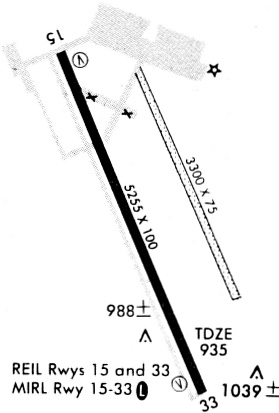
| A110-1 | TURF STRIP 3300 FT X 75 FT PARL TO & EAST OF RWY 15/33 USED BY CROP DUSTERS ONLY. |
| A110-2 | FOR CD CTC HOUSTON ARTCC AT 281-230-5622. |
| A16 | EXTN 101 |
| A70-FUEL-10 | 0LL SELF SVC 100LL. |
| A81-APT | ACTVT REIL RWY 15 & 33; MIRL RWY 15/33 - CTAF. |
Runways
Runway Summary
| Runways: | 15/33 |
| Longest Runway: | 15/33 is 5256 ft (1602 m) long |
| Runways with an Instrument Approach: |
UVA Airport Runway Details
| Runway 15/33 | 5256 ft x 100 ft (1602 m x 30 m) | |
| Runway Length Source: | NGS as of 03/09/2008 | |
| Surface: | Asphalt - Good condition - No special surface treatment | |
| Runway Edge Lights: | Medium Intensity | |
Runway Weight Bearing Capacity (in thousands of pounds) |
||
| Single Wheel Landing Gear: | 30.0 | |
| Dual Wheel Landing Gear: | 40.0 | |
| Dual Tandem Wheel Landing Gear: | 40.0 | |
Runway 15 |
Runway 33 |
|
Elevation: |
941.7 | 924.8 |
Latitude: |
29-13-04.3889N | 29-12-17.2429N |
Longitude: |
099-44-49.4619W | 099-44-24.3631W |
|
Runway True Alignment: |
155 | 335 |
Glide Path Angle: |
3.0 degrees | 3.0 degrees |
Traffic Pattern: |
Left | Left |
Runway Markings Type: |
Nonprecision Instrument | Nonprecision Instrument |
Runway Markings Condition: |
Good | Good |
Object at End: |
TREES | |
Object Height: |
52 | |
Distance from End: |
700 | |
Object Centerline Offset: |
220 ft. left of centerline | |
Visual Glide Slope Indicators: |
4-Light PAPI On Left Side Of Runway | 4-Light PAPI On Left Side Of Runway |
REIL: |
Yes | Yes |
Threshold Crossing Height: |
36 | 35 |
Services
Airframe Repair: |
None |
Powerplant Repair: |
None |
Fuel Available: |
100LL |
Landing Fees: |
No |
Maps & Diagrams
UVA Sectional
Flight Planning
at skyvector.com
at skyvector.com