Location
Latitude: |
30-44-20.1380N (30.738927) |
Longitude: |
098-14-18.9970W (-98.23861) |
Elevation: |
1283.4 feet MSL (391 m MSL) |
Magnetic Variation: |
3.5 E (as of April 2024 from WMM2020 model) |
Time Zone: |
UTC -6.0 (Standard Time) UTC -5.0 (Daylight Savings Time) |
From City: |
01 N.M. SW of Burnet, Texas |
Found On: |
San Antonio Chart |
FAA Region: |
ASW |
Contacts
Manager: |
Publicly owned: |
| ADRIANNE FEILD PO BOX 1369 BURNET, TX 78611 512-756-6655 |
CITY OF BURNET PO BOX 1369 BURNET, TX 78611 512-756-6093 |
Operations
Airport Status: |
Operational |
Facility Use: |
Public |
Type: |
Airport |
Activation Date: |
01/1959 |
Control tower: |
No |
Attendance (Months/Days/Hours): |
Months/Days/Hours ALL/ALL/0800-1800 |
Boundary ARTCC: |
ZHU (Houston) |
Responsible ARTCC: |
ZHU (Houston) |
Lighting Schedule: |
SEE RMK |
Segmented Circle Indicator: |
Yes |
Traffic Pattern Altitude (MSL): |
2283 feet (696 m) |
NOTAMs Facility: |
BMQ |
NOTAM-D Service: |
Yes |
International Airport of Entry: |
No |
Customs Landing Rights: |
No |
Military Landing Rights: |
Yes |
Civil/Military Joint Use: |
No |
Based Aircraft
| Single Engine: | 49 |
| Multi Engine: | 2 |
| Jet Engine: | 1 |
| GA Helicopters: | 1 |
Annual Operations (as of 06/08/2023)
| Total Operations: | 21000 | |
| GA Local: | 15300 | 72.9% |
| GA Itinerant: | 5100 | 24.3% |
| Military Aircraft: | 600 | 2.9% |
Communications
| CTAF: | 122.800 |
| Unicom: | 122.800 |
| ASOS: | 119.925 (512-756-7277) |
- APCH/DEP CTL SVC PRVDD BY HOUSTON ARTCC (ZHU) ON FREQS 132.35/317.5 (LOMETA RCAG).
Fixed Based Operators (FBOs) & Fuel
(Click on a business for detail)
Please help us keep this information up to date. This is a FREE SERVICE just like everything else on Airport Guide! If you see that a business needs to be added, modified, or deleted please fill out our Update Form.
To add, modify, or delete a business click here.
Please help us keep this information up to date. This is a FREE SERVICE just like everything else on Airport Guide! If you see that a business needs to be added, modified, or deleted please fill out our Update Form.
Area Code: 512 |
| Business Name | Frequency | Phone | Fuel Grade |
|---|---|---|---|
| Faulkner's Air Shop
Update FBO info |
Unicom 122.8 | 756-6655 | 100LL, Jet A |
Flight Service Stations
| Primary | Alternate | |
| FSS on Field: | N | |
| FSS Name (ID): | San Angelo(SJT) | |
| Frequency: | ||
| Toll Free Phone: | 1-800-WX-BRIEF |
Instrument Procedures / Charts
FAA Terminal Procedures valid from 0901Z 03/21/24 to 0901Z 04/18/24.
There are various types of charts available for an airport. They are listed in the Page Type column. Here is a legend for those types:
APD - Airport Diagram
DP - Departure Procedure Charts
HOT - Hot Spots
IAP - Instrument Approach Procedure Charts
MIN - Minimums
STAR - Standard Terminal Arrival Charts
| Page Type | Page Name | Volume | Action Since Last Cycle |
|---|---|---|---|
| IAP | RNAV (GPS) RWY 01 | SC-3 | |
| IAP | RNAV (GPS) RWY 19 | SC-3 | |
| MIN | ALTERNATE MINIMUMS | SC-3 | |
| MIN | TAKEOFF MINIMUMS | SC-3 |
Terminal Procedures are only available for airports in several countries with more being added all the time. If you are looking for a specific country's charts, please send an email to support(at)airportguide.com stating the country name. This will be used to prioritize the implementation.
Navigation Aids (Navaids) near KBMQ
| Dist (NM) | ID | Morse Code | Name | Type | Freq | True Hdg | Mag Hdg |
|---|---|---|---|---|---|---|---|
| 0.1 | BMQ | _ . . . _ _ _ _ . _ | Burnet | NDB | 341 | 56 | 53 |
| 27.3 | AGJ | . _ _ _ . . _ _ _ | Gooch Springs | VORTAC | 112.50 | 10 | 7 |
| 28.1 | GRK | _ _ . . _ . _ . _ | Gray | VOR-DME | 111.80 | 51 | 48 |
| 28.5 | LLO | . _ . . . _ . . _ _ _ | Llano | VORTAC | 108.20 | 277 | 273 |
| 29.0 | GUO | _ _ . . . _ _ _ _ | Georgetown | NDB | 332 | 96 | 93 |
| 31.7 | GR | _ _ . . _ . | Starn | NDB | 323 | 35 | 32 |
| 32.2 | IL | . . . _ . . | Iresh | NDB | 278 | 57 | 54 |
| 35.9 | HLR | . . . . . _ . . . _ . | Hood | NDB | 347 | 49 | 46 |
| 40.0 | STV | . . . _ . . . _ | Stonewall | VORTAC | 113.80 | 217 | 213 |
| 42.5 | CWK | _ . _ . . _ _ _ . _ | Centex | VORTAC | 112.80 | 120 | 117 |
| 48.6 | BS | _ . . . . . . | Creed | NDB | 255 | 143 | 140 |
| 49.2 | RU | . _ . . . _ | Garys | NDB | 272 | 162 | 159 |
| 50.5 | TPL | _ . _ _ . . _ . . | Temple | DME | 110.4 | 55 | 52 |
| 53.2 | MNZ | _ _ _ . _ _ . . | Hamilton | NDB | 251 | 4 | 1 |
| 61.7 | BBD | _ . . . _ . . . _ . . | Brady | NDB | 380 | 295 | 291 |
| 66.7 | SAT | . . . . _ _ | San Antonio | VORTAC | 116.80 | 190 | 186 |
| 70.0 | AN | . _ _ . | Alamo | NDB | 368 | 194 | 190 |
| 70.4 | CSI | _ . _ . . . . . . | Center Point | VORTAC | 117.50 | 226 | 222 |
| 72.1 | DHK | _ . . . . . . _ . _ | Randolph | TACAN | 109.90 | 181 | 178 |
| 73.2 | RND | . _ . _ . _ . . | Randolph | VORTAC | 112.30 | 181 | 178 |
Nearby Airports with Fuel
Notices to Airmen (NOTAMS)
Remarks
| A110-1 | DEER INVOF AIRPORT. |
| A110-2 | RWY 19 PREFERRED CALM WIND RWY. |
| A110-3 | FOR CD CTC HOUSTON ARTCC AT 281-230-5622. |
| A14 | ADMIN SERVICES/AMGR 512-715-3214. |
| A16 | FBO. |
| A17 | FOR ARPT ATTENDANT CALL 512-756-6655. |
| A81-APT | DUSK-DAWN. REIL RWY 01 & 19; PAPI RWY 01 & 19; MIRL RWY 01/19 PRESET LOW INTST; TO INCR INTST & ACTVT - CTAF. |
| E111 | PRE-DATES THE ACT. |
Runways
Runway Summary
| Runways: | 01/19 |
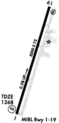
| Longest Runway: | 01/19 is 5001 ft (1524 m) long |
| Runways with an Instrument Approach: |
KBMQ Airport Runway Details
| Runway 01/19 | 5001 ft x 75 ft (1524 m x 23 m) | |
| Runway Length Source: | 3RD PARTY SURVEY as of 08/01/2018 | |
| Surface: | Asphalt - Good condition - No special surface treatment | |
| Runway Edge Lights: | Medium Intensity | |
Runway Weight Bearing Capacity (in thousands of pounds) |
||
| Single Wheel Landing Gear: | 30.0 | |
Runway 01 |
Runway 19 |
|
Elevation: |
1258.4 | 1283.2 |
Latitude: |
30-43-56.3677N | 30-44-43.9077N |
Longitude: |
098-14-26.9571W | 098-14-11.0357W |
|
Runway True Alignment: |
016 | 196 |
Glide Path Angle: |
3.0 degrees | 3.0 degrees |
Traffic Pattern: |
Right | |
Runway Markings Type: |
Nonprecision Instrument | Nonprecision Instrument |
Runway Markings Condition: |
Good | Good |
Object at End: |
PLINE | TREES |
Object Height: |
32 | 28 |
Object Marked/Lighted?: |
Marked | |
Distance from End: |
1300 | 820 |
Object Centerline Offset: |
0 ft. left and right of centerline | 290 ft. left and right of centerline |
Visual Glide Slope Indicators: |
4-Light PAPI On Left Side Of Runway | 4-Light PAPI On Left Side Of Runway |
REIL: |
Yes | Yes |
Threshold Crossing Height: |
43 | 45 |
Services
Airframe Repair: |
Major |
Powerplant Repair: |
Major |
Bottled Oxygen: |
Low Pressure |
Fuel Available: |
100LL |
Landing Fees: |
No |
Parking: |
Hangars and tiedowns available |
Maps & Diagrams
KBMQ Sectional
Flight Planning
at skyvector.com
at skyvector.com