Location
Latitude: |
29-42-20.7000N (29.70575) |
Longitude: |
098-02-35.6000W (-98.043222) |
Elevation: |
658.4 feet MSL (201 m MSL) |
Magnetic Variation: |
3.4 E (as of April 2024 from WMM2020 model) |
Time Zone: |
UTC -6.0 (Standard Time) UTC -5.0 (Daylight Savings Time) |
From City: |
04 N.M. E of New Braunfels, Texas |
Found On: |
San Antonio Chart |
FAA Region: |
ASW |
Contacts
Manager: |
Publicly owned: |
| ROBERT LEE 2333 FM 758 NEW BRAUNFELS, TX 78130 830-221-4290 |
CITY OF NEW BRAUNFELS 550 LANDA ST. NEW BRAUNFELS, TX 78130 (830) 221-4000 |
Operations
Airport Status: |
Operational |
Facility Use: |
Public |
Type: |
Airport |
Activation Date: |
09/1944 |
Control tower: |
Yes |
Attendance (Months/Days/Hours): |
Months/Days/Hours ALL/ALL/0700-1900 |
Boundary ARTCC: |
ZHU (Houston) |
Responsible ARTCC: |
ZHU (Houston) |
Lighting Schedule: |
SEE RMK |
Segmented Circle Indicator: |
Yes |
Traffic Pattern Altitude (MSL): |
1658 feet (505 m) |
NOTAMs Facility: |
BAZ |
NOTAM-D Service: |
Yes |
International Airport of Entry: |
No |
Customs Landing Rights: |
No |
Military Landing Rights: |
Yes |
Civil/Military Joint Use: |
No |
Based Aircraft
| Single Engine: | 124 |
| Multi Engine: | 9 |
| Jet Engine: | 19 |
| GA Helicopters: | 4 |
Annual Operations (as of 12/31/2023)
| Total Operations: | 76067 | |
| Air Taxi: | 3533 | 4.6% |
| GA Local: | 40692 | 53.5% |
| GA Itinerant: | 29511 | 38.8% |
| Military Aircraft: | 2331 | 3.1% |
Communications
| CTAF: | 127.050 |
| Unicom: | 122.700 |
| Tower: | NEW BRAUNFELS 127.05 285.4 Hrs: 0700-1900 |
| Clearance Del.: | 134.75 |
| Ground: | 120.175 |
| Approach: | SAN ANTONIO |
| Departure: | SAN ANTONIO |
| ATIS: | 119.325 Hrs: 24 |
| ASOS: | 119.325 (830-629-7979) |
Fixed Based Operators (FBOs) & Fuel
(Click on a business for detail)
Please help us keep this information up to date. This is a FREE SERVICE just like everything else on Airport Guide! If you see that a business needs to be added, modified, or deleted please fill out our Update Form.
To add, modify, or delete a business click here.
Please help us keep this information up to date. This is a FREE SERVICE just like everything else on Airport Guide! If you see that a business needs to be added, modified, or deleted please fill out our Update Form.
Area Code: 830 |
| Business Name | Frequency | Phone | Fuel Grade |
|---|---|---|---|
| Brauntex Aviation
Update FBO info |
629-1700 | 100LL, Jet A | |
| City Terminal
Update FBO info |
625-1501 | 100LL, Jet A | |
| Southern Wings
Update FBO info |
Unicom 122.7 | 606-4141 |
Flight Service Stations
| Primary | Alternate | |
| FSS on Field: | N | |
| FSS Name (ID): | San Angelo(SJT) | |
| Frequency: | ||
| Toll Free Phone: | 1-800-WX-BRIEF |
Instrument Procedures / Charts
FAA Terminal Procedures valid from 0901Z 03/21/24 to 0901Z 04/18/24.
There are various types of charts available for an airport. They are listed in the Page Type column. Here is a legend for those types:
APD - Airport Diagram
DP - Departure Procedure Charts
HOT - Hot Spots
IAP - Instrument Approach Procedure Charts
MIN - Minimums
STAR - Standard Terminal Arrival Charts
| Page Type | Page Name | Volume | Action Since Last Cycle |
|---|---|---|---|
| APD | AIRPORT DIAGRAM | SC-3 | |
| DP | ALISS SIX (RNAV) | SC-3 | |
| DP | SLENA ONE (RNAV) | SC-3 | |
| DP | SNIDR ONE (RNAV) | SC-3 | |
| DP | TJANO ONE (RNAV) | SC-3 | |
| DP | YODUH ONE (RNAV) | SC-3 | |
| HOT | HOT SPOT | SC-3 | |
| IAP | RNAV (GPS) RWY 13 | SC-3 | |
| IAP | RNAV (GPS) RWY 17 | SC-3 | |
| IAP | RNAV (GPS) RWY 31 | SC-3 | |
| IAP | RNAV (GPS) RWY 35 | SC-3 | |
| IAP | VOR/DME-A | SC-3 | |
| MIN | ALTERNATE MINIMUMS | SC-3 | |
| MIN | TAKEOFF MINIMUMS | SC-3 | |
| STAR | CRVZA ONE (RNAV) | SC-3 | |
| STAR | CRVZA ONE (RNAV)[DELIMITER] CONT.1 | SC-3 | |
| STAR | CRVZA ONE (RNAV)[DELIMITER] CONT.2 | SC-3 | |
| STAR | DNKIN ONE (RNAV) | SC-3 | |
| STAR | DNKIN ONE (RNAV)[DELIMITER] CONT.1 | SC-3 | |
| STAR | POPPO ONE (RNAV) | SC-3 | |
| STAR | POPPO ONE (RNAV)[DELIMITER] CONT.1 | SC-3 | |
| STAR | POPPO ONE (RNAV)[DELIMITER] CONT.2 | SC-3 | |
| STAR | QERVO ONE (RNAV) | SC-3 | |
| STAR | QERVO ONE (RNAV)[DELIMITER] CONT.1 | SC-3 | |
| STAR | QERVO ONE (RNAV)[DELIMITER] CONT.2 | SC-3 |
Terminal Procedures are only available for airports in several countries with more being added all the time. If you are looking for a specific country's charts, please send an email to support(at)airportguide.com stating the country name. This will be used to prioritize the implementation.
Navigation Aids (Navaids) near KBAZ
| Dist (NM) | ID | Morse Code | Name | Type | Freq | True Hdg | Mag Hdg |
|---|---|---|---|---|---|---|---|
| 15.5 | DHK | _ . . . . . . _ . _ | Randolph | TACAN | 109.90 | 229 | 226 |
| 15.9 | RU | . _ . . . _ | Garys | NDB | 272 | 17 | 14 |
| 16.9 | RND | . _ . _ . _ . . | Randolph | VORTAC | 112.30 | 228 | 225 |
| 22.1 | SAT | . . . . _ _ | San Antonio | VORTAC | 116.80 | 260 | 257 |
| 24.5 | SAT | . . . . _ _ | San Antonio | VOT | 110.40 | 245 | 242 |
| 28.1 | AN | . _ _ . | Alamo | NDB | 368 | 258 | 254 |
| 29.9 | BS | _ . . . . . . | Creed | NDB | 255 | 39 | 36 |
| 33.8 | KSY | _ . _ . . . _ . _ _ | Kelly | TACAN | 112.00 | 236 | 232 |
| 34.0 | SSF | . . . . . . . . _ . | Stinson | VOR | 108.40 | 218 | 215 |
| 45.7 | STV | . . . _ . . . _ | Stonewall | VORTAC | 113.80 | 311 | 307 |
| 48.4 | CWK | _ . _ . . _ _ _ . _ | Centex | VORTAC | 112.80 | 33 | 30 |
| 52.8 | OKT | _ _ _ _ . _ _ | Yoakum | NDB | 350 | 116 | 113 |
| 57.9 | HHH | . . . . . . . . . . . . | Devine | NDB | 359 | 234 | 230 |
| 61.7 | GUO | _ _ . . . _ _ _ _ | Georgetown | NDB | 332 | 17 | 14 |
| 62.2 | HMA | . . . . _ _ . _ | Hondo | NDB | 329 | 251 | 247 |
| 62.3 | CSI | _ . _ . . . . . . | Center Point | VORTAC | 117.50 | 282 | 278 |
| 62.9 | BMQ | _ . . . _ _ _ _ . _ | Burnet | NDB | 341 | 350 | 347 |
| 63.0 | HDO | . . . . _ . . _ _ _ | Hondo | VOR-DME | 109.40 | 250 | 246 |
| 72.3 | THX | _ . . . . _ . . _ | Three Rivers | VORTAC | 111.40 | 184 | 181 |
| 73.7 | VCT | . . . _ _ . _ . _ | Victoria | VOR-DME | 109.00 | 130 | 127 |
Nearby Airports with Fuel
Notices to Airmen (NOTAMS)
Remarks
| A110-3 | BIRDS INVOF ARPT. |
| A110-4 | HIGH PER MIL ACFT OPRG AT RANDOLPH AFB AUX FLD (SEGUIN-SEQ). |
| A110-5 | FOR CD WHEN ATCT IS CLSD CTC SAT APCH AT 210-805-5516. |
| A57-17 | APCH RATIO 50:1 AT DSPLCD THR. |
| A70-FUEL-10 | 0LL FUEL 24 HR SELF SVC. FOR FULL SERVE FUEL CALL 830-221-4290; AFT HRS CALL 830-221-4100. |
| A81-APT | ACTVT MIRL RWY 13/31, RWY 17/35 - CTAF. |
| E111 | EXISTED PRIOR TO 1959. |
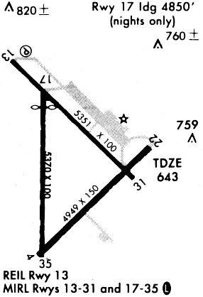
Runways
Runway Summary
| Runways: | 13/31 17/35 |
| Longest Runway: | 13/31 is 6503 ft (1982 m) long |
| Runways with an Instrument Approach: |
KBAZ Airport Runway Details
| Runway 13/31 | 6503 ft x 100 ft (1982 m x 30 m) | |
| Runway Length Source: | 3RD PARTY SURVEY as of 01/13/2015 | |
| Surface: | Asphalt - Good condition - No special surface treatment | |
| Runway Edge Lights: | Medium Intensity | |
Runway Weight Bearing Capacity (in thousands of pounds) |
||
| Single Wheel Landing Gear: | 30.0 | |
| Dual Wheel Landing Gear: | 60.0 | |
Runway 13 |
Runway 31 |
|
Elevation: |
658.4 | 643.5 |
Latitude: |
29-42-54.3960N | 29-42-08.3000N |
Longitude: |
098-02-59.7859W | 098-02-08.3200W |
|
Runway True Alignment: |
136 | 316 |
Glide Path Angle: |
3.0 degrees | 3.0 degrees |
Traffic Pattern: |
Left | Left |
Runway Markings Type: |
Nonprecision Instrument | Nonprecision Instrument |
Runway Markings Condition: |
Good | Good |
Visual Glide Slope Indicators: |
4-Light PAPI On Left Side Of Runway | 4-Light PAPI On Left Side Of Runway |
Approach Light System: |
1,400 Foot Medium Intensity Approach Lighting System | |
REIL: |
Yes | |
Threshold Crossing Height: |
50 | 50 |
| Runway 17/35 | 5364 ft x 100 ft (1635 m x 30 m) | |
| Runway Length Source: | 3RD PARTY SURVEY as of 01/13/2015 | |
| Surface: | Asphalt - Good condition - No special surface treatment | |
| Runway Edge Lights: | Medium Intensity | |
Runway Weight Bearing Capacity (in thousands of pounds) |
||
| Single Wheel Landing Gear: | 25.0 | |
Runway 17 |
Runway 35 |
|
Elevation: |
646.6 | 644.5 |
Latitude: |
29-42-34.2592N | 29-41-41.1665N |
Longitude: |
098-02-37.0800W | 098-02-37.8309W |
|
Runway True Alignment: |
181 | 001 |
Glide Path Angle: |
0.0 degrees | 0.0 degrees |
Traffic Pattern: |
Left | Left |
Runway Markings Type: |
Nonprecision Instrument | Nonprecision Instrument |
Runway Markings Condition: |
Fair | Fair |
Object at End: |
PLINE | |
Object Height: |
45 | |
Distance from End: |
1300 | |
Threshold Elevation: |
648.0 | |
Displaced Threshold: |
522 | |
Threshold Latitude: |
29-42-29.0968N | |
Threshold Longitude: |
098-02-37.1524W |
Services
Bottled Oxygen: |
None |
Bulk Oxygen: |
None |
Fuel Available: |
100LL |
Landing Fees: |
No |
Parking: |
Tiedowns available |
Maps & Diagrams
KBAZ Sectional
Flight Planning
at skyvector.com
at skyvector.com