
Location
Latitude: |
30-11-40.2980N (30.194527) |
Longitude: |
097-40-11.5540W (-97.669876) |
Elevation: |
541.5 feet MSL (165 m MSL) |
Magnetic Variation: |
3.2 E (as of April 2024 from WMM2020 model) |
Time Zone: |
UTC -6.0 (Standard Time) UTC -5.0 (Daylight Savings Time) |
From City: |
05 N.M. SE of Austin, Texas |
Found On: |
San Antonio Chart |
FAA Region: |
ASW |
Contacts
Manager: |
Publicly owned: |
| JIM SMITH 3600 PRESIDENTIAL BLVD, SUITE 411 AUSTIN, TX 78719 512-530-2242 |
CITY OF AUSTIN PO BOX 1088 AUSTIN, TX 78767 512-974-2000 |
Operations
Airport Status: |
Operational |
Facility Use: |
Public |
Type: |
Airport |
Activation Date: |
07/1943 |
Control tower: |
Yes |
Attendance (Months/Days/Hours): |
Months/Days/Hours ALL/ALL/ALL |
Boundary ARTCC: |
ZHU (Houston) |
Responsible ARTCC: |
ZHU (Houston) |
Lighting Schedule: |
SS-SR |
Segmented Circle Indicator: |
No |
Traffic Pattern Altitude (MSL): |
1542 feet (470 m) |
NOTAMs Facility: |
AUS |
NOTAM-D Service: |
Yes |
Customs Landing Rights: |
Yes |
Military Landing Rights: |
Yes |
Civil/Military Joint Use: |
No |
Aircraft Rescue and Firefighting: |
Class I ARFF Index: D Air Carrier Service: Scheduled Certification Date: 06/1997 |
Based Aircraft
| Single Engine: | 80 |
| Multi Engine: | 13 |
| Jet Engine: | 54 |
| GA Helicopters: | 5 |
| Military Aircraft: | 22 |
Annual Operations (as of 03/31/2023)
| Total Operations: | 208864 | |
| Commercial: | 138680 | 66.4% |
| Air Taxi: | 20577 | 9.9% |
| GA Local: | 200 | 0.1% |
| GA Itinerant: | 44827 | 21.5% |
| Military Aircraft: | 4580 | 2.2% |
Communications
| Unicom: | 122.950 |
| Tower: | AUSTIN 121.0 281.5 118.225 254.25 Hrs: 24 |
| Clearance Del.: | 125.5 263.0 |
| Ground: | 121.9 348.6 |
| Approach: | AUSTIN 119.0 ;WEST 120.875 ;SOUTH 127.225 ;EAST 270.25 ;SOUTH 317.65 ;EAST 370.85 ;WEST Hrs: 24 |
| Departure: | AUSTIN 119.0 ;WEST 120.875 ;SOUTH 127.225 ;EAST 270.25 ;SOUTH 317.65 ;EAST 370.85 ;WEST Hrs: 24 |
| ATIS: | 124.4 Hrs: 24 |
| ASOS: | (512-369-7881) |
| KALLA STAR: | 119.0 |
| SEWZY STAR: | 127.225 |
| CLASS C: | 317.65 ;EAST |
| WLEEE STAR: | 317.65 |
| KALLA STAR: | 370.85 |
| MUCKY DP: | 119.0 |
| WLEEE STAR: | 127.225 |
| PALMS DP: | 317.65 ;EAST |
| MUCKY DP: | 370.85 |
| CLASS C: | 119.0 ;WEST |
| CLASS C: | 127.225 ;EAST |
| AEROZ DP: | 317.65 |
| LAIKS STAR: | 119.0 ;WEST |
| CLASS C: | 120.875 ;SOUTH |
| PALMS DP: | 127.225 ;EAST |
| BITER STAR: | 317.65 |
| CLASS C: | 370.85 ;WEST |
| AEROZ DP: | 119.0 |
| BITER STAR: | 127.225 |
| BLEWE STAR: | 317.65 |
| LAIKS STAR: | 370.85 ;WEST |
| AUSTIN DP: | 119.0 |
| BLEWE STAR: | 127.225 |
| CLASS C: | 270.25 ;SOUTH |
| CENTEX DP: | 317.65 |
| AUSTIN DP: | 370.85 |
| BNDIA DP: | 119.0 |
| CENTEX DP: | 127.225 |
| FINAL: | 279.55 ;AS ASIGNED |
| ILEXY DP: | 317.65 |
| BNDIA DP: | 370.85 |
| DXEEE STAR: | 119.0 |
| ILEXY DP: | 127.225 |
| SAYBR DP: | 317.65 |
| DXEEE STAR: | 370.85 |
| ELOEL DP: | 119.0 |
| FINAL: | 125.325 |
| SAYBR DP: | 127.225 |
| SEWZY STAR: | 317.65 |
| ELOEL DP: | 370.85 |
Fixed Based Operators (FBOs) & Fuel
(Click on a business for detail)
Please help us keep this information up to date. This is a FREE SERVICE just like everything else on Airport Guide! If you see that a business needs to be added, modified, or deleted please fill out our Update Form.
To add, modify, or delete a business click here.
Please help us keep this information up to date. This is a FREE SERVICE just like everything else on Airport Guide! If you see that a business needs to be added, modified, or deleted please fill out our Update Form.
Area Code: 512 |
| Business Name | Frequency | Phone | Fuel Grade |
|---|---|---|---|
| Austin Aero Jet Center
Update FBO info |
122.95, Arinc 130.22 | 800-727-2376, 479-6666 | 100LL, Jet A |
| First Class Aviation
Website Update FBO info |
459-4951 | ||
| Signature Flight Support
Website Update FBO info |
Unicom: 122.95, Arinc: 130.375 | +1 512 530 5451 | 100LL, Jet A |
Flight Service Stations
| Primary | Alternate | |
| FSS on Field: | N | |
| FSS Name (ID): | San Angelo(SJT) | |
| Frequency: | ||
| Toll Free Phone: | 1-800-WX-BRIEF |
Instrument Procedures / Charts
FAA Terminal Procedures valid from 0901Z 03/21/24 to 0901Z 04/18/24.
There are various types of charts available for an airport. They are listed in the Page Type column. Here is a legend for those types:
APD - Airport Diagram
DP - Departure Procedure Charts
HOT - Hot Spots
IAP - Instrument Approach Procedure Charts
MIN - Minimums
STAR - Standard Terminal Arrival Charts
Terminal Procedures are only available for airports in several countries with more being added all the time. If you are looking for a specific country's charts, please send an email to support(at)airportguide.com stating the country name. This will be used to prioritize the implementation.
Navigation Aids (Navaids) near AUS
| Dist (NM) | ID | Morse Code | Name | Type | Freq | True Hdg | Mag Hdg |
|---|---|---|---|---|---|---|---|
| 6.3 | BS | _ . . . . . . | Creed | NDB | 255 | 182 | 179 |
| 13.2 | CWK | _ . _ . . _ _ _ . _ | Centex | VORTAC | 112.80 | 33 | 30 |
| 20.3 | RU | . _ . . . _ | Garys | NDB | 272 | 225 | 222 |
| 29.4 | GUO | _ _ . . . _ _ _ _ | Georgetown | NDB | 332 | 358 | 355 |
| 43.9 | BMQ | _ . . . _ _ _ _ . _ | Burnet | NDB | 341 | 318 | 315 |
| 49.8 | IL | . . . _ . . | Iresh | NDB | 278 | 357 | 354 |
| 50.2 | DHK | _ . . . . . . _ . _ | Randolph | TACAN | 109.90 | 218 | 215 |
| 50.8 | GRK | _ _ . . _ . _ . _ | Gray | VOR-DME | 111.80 | 351 | 348 |
| 51.6 | RND | . _ . _ . _ . . | Randolph | VORTAC | 112.30 | 218 | 215 |
| 52.8 | SAT | . . . . _ _ | San Antonio | VORTAC | 116.80 | 231 | 228 |
| 53.7 | STV | . . . _ . . . _ | Stonewall | VORTAC | 113.80 | 271 | 268 |
| 56.1 | HLR | . . . . . _ . . . _ . | Hood | NDB | 347 | 357 | 354 |
| 57.5 | SAT | . . . . _ _ | San Antonio | VOT | 110.40 | 226 | 223 |
| 58.6 | AN | . _ _ . | Alamo | NDB | 368 | 233 | 230 |
| 59.3 | IDU | . . _ . . . . _ | Industry | VORTAC | 110.20 | 103 | 100 |
| 59.4 | GR | _ _ . . _ . | Starn | NDB | 323 | 349 | 346 |
| 59.7 | OKT | _ _ _ _ . _ _ | Yoakum | NDB | 350 | 152 | 149 |
| 62.2 | TPL | _ . _ _ . . _ . . | Temple | DME | 110.4 | 11 | 8 |
| 64.3 | AGJ | . _ _ _ . . _ _ _ | Gooch Springs | VORTAC | 112.50 | 337 | 334 |
| 67.6 | KSY | _ . _ . . . _ . _ _ | Kelly | TACAN | 112.00 | 224 | 221 |
Nearby Airports with Fuel
Notices to Airmen (NOTAMS)
Remarks
| A110-1 | BIRD ACTIVITY ON & INVOF ARPT. |
| A110-10 | DECLARED LOW VISIBILITY CONDS REQUIRE ATCT COMMUNICATION PRIOR TO PUSH BACK. |
| A110-12 | PPR GA ACFT ON THE PSGR TERMINAL APRON, CALL OPS 512-530-7550. |
| A110-13 | ARNG: OPR 1300-2300++ TUE-FRI, DSN 954-5001 EXT 7024614, C512-356-7900 EXT 7024614. |
| A110-14 | TWY A CLSD TO ACFT WITH WINGSPAN MORE THAN 171 FT. |
| A110-15 | PPR FOR NON STATE OF TEXAS AIRCRAFT ENTERING THE STATE RAMP ABEAM TWY E. CALL STATE OPS 512-936-8900 OR FREQ. 131.375. |
| A110-16 | TXLN R4 CLSD TO AFCT WITH WINGSPAN MORE THAN 135. |
| A110-17 | TXLN C2 CLSD TO AFCT WITH WINGSPAN MORE THAN 171. |
| A110-18 | TXLN R1, R3, R5 CLSD TO AFCT WITH WINGSPAN MORE THAN 118. |
| A110-19 | TXLN C2 BTWN TWY C AND G1, AND TXLN R1 CLSD 2000L-0800L. |
| A110-5 | DURG THE HRS 0000-0600 ARRG ACFT WILL BE ASGND RWY 36L OR RWY 36R & DEPARTING ACFT WILL BE ASGND RWY 18L OR RWY 18R TO AVOID NOISE SENSITIVE AREAS. |
| A110-8 | NOISE ABATEMENT: ALL DEP FOLLOW ATC INSTRUCTIONS; CLIMB ASAP TO 4000 FT OR ABOVE. |
| A110-9 | PPR ENGINE MAINTENANCE RUN UPS CALL OPS 512-530-7550. |
Runways
Runway Summary
| Runways: | 18L/36R 18R/36L H1 H2 H3 |
| Longest Runway: | 18R/36L is 12250 ft (3734 m) long |
| Runways with an Instrument Approach: | 18L, 36R, 18R, 36L |
AUS Airport Runway Details
| Runway 18L/36R | 9000 ft x 150 ft (2743 m x 46 m) | |
| Runway Length Source: | 3RD PARTY SURVEY as of 06/27/2016 | |
| Surface: | Concrete - Good condition - Saw-cut or plastic grooved | |
| Runway Pavement Class: | 92 /R/B/W/T | |
| Runway Edge Lights: | High Intensity | |
Runway Weight Bearing Capacity (in thousands of pounds) |
||
| Single Wheel Landing Gear: | 75.0 | |
| Dual Wheel Landing Gear: | 210.0 | |
| Dual Tandem Wheel Landing Gear: | 618.0 | |
| Dual Dual Tandem Wheel Landing Gear: | 913.0 | |
Runway 18L |
Runway 36R |
|
Elevation: |
491.6 | 473.6 |
Latitude: |
30-12-13.7882N | 30-10-44.7277N |
Longitude: |
097-39-28.4078W | 097-39-26.0760W |
|
Runway True Alignment: |
179 | 359 |
ILS Type: |
ILS/DME | ILS/DME |
Glide Path Angle: |
3.0 degrees | 3.0 degrees |
Traffic Pattern: |
Left | Right |
Runway Markings Type: |
Precision Instrument | Precision Instrument |
Runway Markings Condition: |
Good | Good |
Object at End: |
TOWER | |
Object Height: |
90 | |
Object Marked/Lighted?: |
Lighted | |
Distance from End: |
3807 | |
Object Centerline Offset: |
236 ft. right of centerline | |
Visual Glide Slope Indicators: |
4-Light PAPI On Left Side Of Runway | 4-Light PAPI On Left Side Of Runway |
Runway Visual Range (RVR): |
Touchdown, Midfield, Rollout | Touchdown, Midfield, Rollout |
Approach Light System: |
Standard 2,400 Foot High Intensity Approach Lighting System With Sequenced Flashers, Cat. II or III Config. | 1,400 Foot Medium Intensity Approach Lighting System With Runway Alignment Indicator Lights |
REIL: |
No | No |
Touchdown Lights: |
Yes | Yes |
Centerline Lights: |
Yes | Yes |
Threshold Crossing Height: |
74 | 59 |
Declared Distances |
||
Take Off Run Avbl. (TORA): |
9000 | 9000 |
Take Off Distance Avbl. (TODA): |
9000 | 9000 |
Actual Stop Dist. Avbl. (ASDA): |
9000 | 9000 |
Landing Dist. Avbl. (LDA): |
9000 | 9000 |
| Runway 18R/36L | 12250 ft x 150 ft (3734 m x 46 m) | |
| Runway Length Source: | 3RD PARTY SURVEY as of 06/27/2016 | |
| Surface: | Concrete - Good condition - Saw-cut or plastic grooved | |
| Runway Pavement Class: | 98 /R/B/W/T | |
| Runway Edge Lights: | High Intensity | |
Runway Weight Bearing Capacity (in thousands of pounds) |
||
| Single Wheel Landing Gear: | 75.0 | |
| Dual Wheel Landing Gear: | 210.0 | |
| Dual Tandem Wheel Landing Gear: | 618.0 | |
| Dual Dual Tandem Wheel Landing Gear: | 913.0 | |
Runway 18R |
Runway 36L |
|
Elevation: |
541.4 | 487.3 |
Latitude: |
30-12-49.0181N | 30-10-47.7956N |
Longitude: |
097-40-45.7132W | 097-40-42.5089W |
|
Runway True Alignment: |
179 | 359 |
ILS Type: |
ILS/DME | ILS/DME |
Glide Path Angle: |
3.0 degrees | 3.0 degrees |
Traffic Pattern: |
Right | Left |
Runway Markings Type: |
Precision Instrument | Precision Instrument |
Runway Markings Condition: |
Good | Good |
Arresting Device: |
BAK-12B | |
Object Centerline Offset: |
236 ft. right of centerline | |
Visual Glide Slope Indicators: |
4-Light PAPI On Left Side Of Runway | 4-Light PAPI On Left Side Of Runway |
Runway Visual Range (RVR): |
Touchdown, Rollout | Touchdown, Rollout |
Approach Light System: |
1,400 Foot Medium Intensity Approach Lighting System | 1,400 Foot Medium Intensity Approach Lighting System |
REIL: |
No | No |
Threshold Crossing Height: |
60 | 60 |
Declared Distances |
||
Take Off Run Avbl. (TORA): |
12250 | 12250 |
Take Off Distance Avbl. (TODA): |
12250 | 12250 |
Actual Stop Dist. Avbl. (ASDA): |
12250 | 12250 |
Landing Dist. Avbl. (LDA): |
12250 | 12250 |
| Helipad H1 | 60 ft x 60 ft (18 m x 18 m) | |
| Runway Length Source: | FAA as of 05/06/2004 | |
| Surface: | Concrete - Good condition - No special surface treatment | |
Helipad H1 |
||
Elevation: |
541.5 | |
Latitude: |
30-11-07.7100N | |
Longitude: |
097-39-39.6200W | |
Glide Path Angle: |
0.0 degrees | 0.0 degrees |
Runway Markings Type: |
None | |
Runway Markings Condition: |
Good | |
Object Centerline Offset: |
236 ft. right of centerline |
| Helipad H2 | 60 ft x 60 ft (18 m x 18 m) | |
| Runway Length Source: | FAA as of 05/19/2005 | |
| Surface: | Concrete - Good condition - No special surface treatment | |
Helipad H2 |
||
Elevation: |
541.5 | |
Latitude: |
30-11-15.6200N | |
Longitude: |
097-39-39.8400W | |
Glide Path Angle: |
0.0 degrees | 0.0 degrees |
Runway Markings Type: |
None | |
Runway Markings Condition: |
Good | |
Object Centerline Offset: |
236 ft. right of centerline |
| Helipad H3 | 50 ft x 50 ft (15 m x 15 m) | |
| Runway Length Source: | FAA as of 12/23/2019 | |
| Surface: | Concrete - Good condition - No special surface treatment | |
Helipad H3 |
||
Elevation: |
479.0 | |
Latitude: |
30-10-46.1500N | |
Longitude: |
097-40-23.5500W | |
Glide Path Angle: |
0.0 degrees | 0.0 degrees |
Runway Markings Type: |
Basic | |
Runway Markings Condition: |
Good | |
Object Centerline Offset: |
236 ft. right of centerline |
Services
Airframe Repair: |
Major |
Powerplant Repair: |
Major |
Bulk Oxygen: |
None |
Fuel Available: |
100LL, Jet A, Jet A+ |
Landing Fees: |
No |
Parking: |
Tiedowns available |
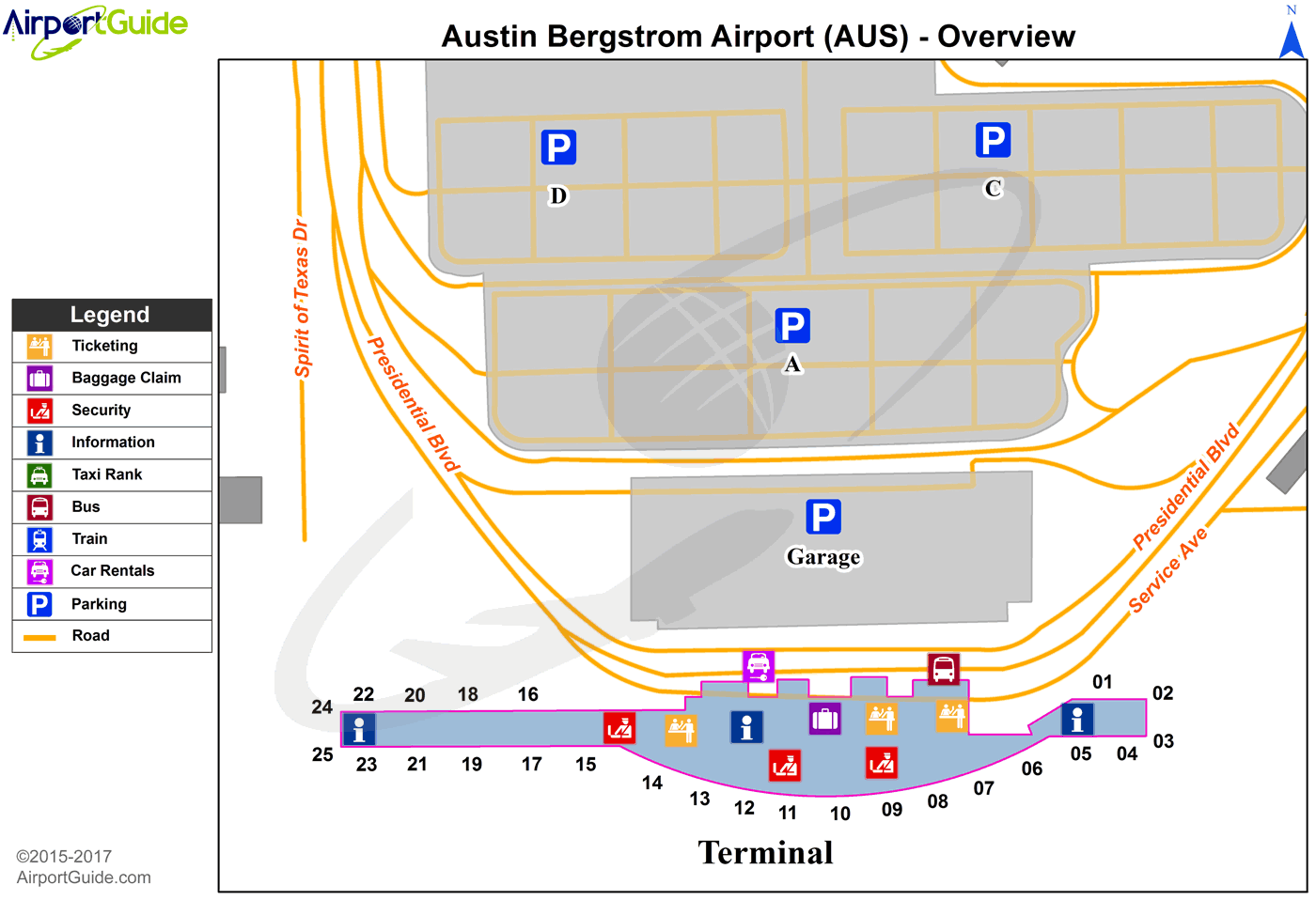
Maps & Diagrams
AUS Sectional
Flight Planning
at skyvector.com
at skyvector.com
