Location
Latitude: |
30-43-55.8949N (30.732193) |
Longitude: |
099-11-02.4215W (-99.184006) |
Elevation: |
1514.0 feet MSL (461 m MSL) |
Magnetic Variation: |
4 E (as of April 2024 from WMM2020 model) |
Time Zone: |
UTC -6.0 (Standard Time) UTC -5.0 (Daylight Savings Time) |
From City: |
03 N.M. SE of Mason, Texas |
Found On: |
San Antonio Chart |
FAA Region: |
ASW |
Contacts
Manager: |
Publicly owned: |
| C. SHEREE HARDIN COUNTY COURTHOUSE, 201 FT MCKAVITT MASON, TX 76856 325-347-5556 |
MASON COUNTY COURTHOUSE, 201 FT MCKAVITT MASON, TX 76856 325-347-5556 |
Operations
Airport Status: |
Operational |
Facility Use: |
Public |
Type: |
Airport |
Activation Date: |
02/1945 |
Control tower: |
No |
Attendance (Months/Days/Hours): |
Months/Days/Hours Unattended |
Boundary ARTCC: |
ZHU (Houston) |
Responsible ARTCC: |
ZHU (Houston) |
Lighting Schedule: |
SS-SR |
Segmented Circle Indicator: |
Yes |
Traffic Pattern Altitude (MSL): |
2514 feet (766 m) |
NOTAMs Facility: |
SJT |
NOTAM-D Service: |
Yes |
International Airport of Entry: |
No |
Customs Landing Rights: |
No |
Civil/Military Joint Use: |
No |
Based Aircraft
| Single Engine: | 5 |
Annual Operations (as of 06/03/2023)
| Total Operations: | 2000 | |
| GA Local: | 800 | 40.0% |
| GA Itinerant: | 1200 | 60.0% |
Communications
| CTAF: | 122.900 |
- APCH/DEP CTL SVC PRVDD BY HOUSTON ARTCC (ZHU) ON FREQS 132.35/317.5 (LOMETA RCAG).
Fixed Based Operators (FBOs) & Fuel
(Click on a business for detail)
Please help us keep this information up to date. This is a FREE SERVICE just like everything else on Airport Guide! If you see that a business needs to be added, modified, or deleted please fill out our Update Form.
To add, modify, or delete a business click here.
Please help us keep this information up to date. This is a FREE SERVICE just like everything else on Airport Guide! If you see that a business needs to be added, modified, or deleted please fill out our Update Form.
Area Code: 915 |
| Business Name | Frequency | Phone | Fuel Grade |
|---|---|---|---|
| Jordan Aircraft Services
Update FBO info |
347-6434 |
Flight Service Stations
| Primary | Alternate | |
| FSS on Field: | N | |
| FSS Name (ID): | San Angelo(SJT) | |
| Frequency: | ||
| Toll Free Phone: | 1-800-WX-BRIEF |
Instrument Procedures / Charts
FAA Terminal Procedures valid from 0901Z 03/21/24 to 0901Z 04/18/24.
There are various types of charts available for an airport. They are listed in the Page Type column. Here is a legend for those types:
APD - Airport Diagram
DP - Departure Procedure Charts
HOT - Hot Spots
IAP - Instrument Approach Procedure Charts
MIN - Minimums
STAR - Standard Terminal Arrival Charts
| Page Type | Page Name | Volume | Action Since Last Cycle |
|---|---|---|---|
| IAP | RNAV (GPS) RWY 18 | SC-3 | |
| IAP | RNAV (GPS) RWY 36 | SC-3 | |
| IAP | VOR-A | SC-3 | |
| MIN | TAKEOFF MINIMUMS | SC-3 |
Terminal Procedures are only available for airports in several countries with more being added all the time. If you are looking for a specific country's charts, please send an email to support(at)airportguide.com stating the country name. This will be used to prioritize the implementation.
Navigation Aids (Navaids) near T92
| Dist (NM) | ID | Morse Code | Name | Type | Freq | True Hdg | Mag Hdg |
|---|---|---|---|---|---|---|---|
| 20.8 | LLO | . _ . . . _ . . _ _ _ | Llano | VORTAC | 108.20 | 79 | 75 |
| 27.7 | BBD | _ . . . _ . . . _ . . | Brady | NDB | 380 | 345 | 341 |
| 33.7 | JCT | . _ _ _ _ . _ . _ | Junction | VORTAC | 116.00 | 256 | 252 |
| 40.1 | STV | . . . _ . . . _ | Stonewall | VORTAC | 113.80 | 141 | 137 |
| 48.6 | CSI | _ . _ . . . . . . | Center Point | VORTAC | 117.50 | 181 | 177 |
| 48.9 | BMQ | _ . . . _ _ _ _ . _ | Burnet | NDB | 341 | 89 | 85 |
| 60.1 | AGJ | . _ _ _ . . _ _ _ | Gooch Springs | VORTAC | 112.50 | 62 | 58 |
| 69.9 | UBC | . . _ _ . . . _ . _ . | Ballinger | NDB | 239 | 324 | 320 |
| 70.6 | BWD | _ . . . . _ _ _ . . | Brownwood | VOR-DME | 113.55 | 9 | 5 |
| 72.0 | RSG | . _ . . . . _ _ . | Rocksprings | VORTAC | 114.55 | 233 | 229 |
| 72.1 | GR | _ _ . . _ . | Starn | NDB | 323 | 68 | 64 |
| 72.8 | GRK | _ _ . . _ . _ . _ | Gray | VOR-DME | 111.80 | 75 | 71 |
| 74.6 | AN | . _ _ . | Alamo | NDB | 368 | 154 | 150 |
| 75.3 | SAT | . . . . _ _ | San Antonio | VORTAC | 116.80 | 149 | 145 |
| 75.3 | MNZ | _ _ _ . _ _ . . | Hamilton | NDB | 251 | 44 | 40 |
| 75.9 | SJT | . . . . _ _ _ _ | San Angelo | VORTAC | 115.10 | 300 | 296 |
| 76.0 | SOA | . . . _ _ _ . _ | Sonora | NDB | 371 | 263 | 259 |
| 77.6 | GUO | _ _ . . . _ _ _ _ | Georgetown | NDB | 332 | 91 | 87 |
| 78.0 | IL | . . . _ . . | Iresh | NDB | 278 | 76 | 72 |
| 78.8 | SJ | . . . . _ _ _ | Woole | NDB | 356 | 295 | 291 |
Nearby Airports with Fuel
Notices to Airmen (NOTAMS)
Remarks
| A110-1 | HVY TSNT TFC NOV-JAN. |
| A110-2 | DEER ON AND INVOF RWY. |
| A110-3 | FOR CD CTC HOUSTON ARTCC AT 281-230-5622. |
| A14 | COUNTY JUDGE/ARPT MGR. |
| A70-FUEL-10 | 0LL FUEL 24 HRS SELF SERVE. FOR ASSITANCE CALL 325-347-5252 (COUNTY SHERIFF). |
Runways
Runway Summary
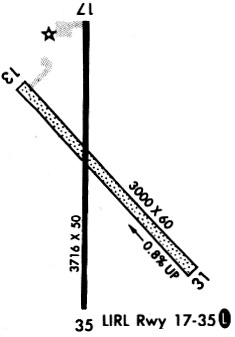
| Runways: | 18/36 |
| Longest Runway: | 18/36 is 3716 ft (1133 m) long |
| Runways with an Instrument Approach: |
T92 Airport Runway Details
| Runway 18/36 | 3716 ft x 50 ft (1133 m x 15 m) | |
| Runway Length Source: | NGS as of 09/26/1995 | |
| Surface: | Asphalt - Fair condition - No special surface treatment | |
| Runway Edge Lights: | Low Intensity | |
Runway 18 |
Runway 36 |
|
Elevation: |
1501.8 | 1497.9 |
Latitude: |
30-44-14.3358N | 30-43-37.5693N |
Longitude: |
099-11-03.0761W | 099-11-03.8465W |
|
Runway True Alignment: |
181 | 001 |
Glide Path Angle: |
0.0 degrees | 0.0 degrees |
Traffic Pattern: |
Left | Left |
Runway Markings Type: |
Nonprecision Instrument | Nonprecision Instrument |
Runway Markings Condition: |
Good | Good |
Object at End: |
TREES | |
Object Height: |
29 | |
Distance from End: |
965 | |
Object Centerline Offset: |
0 ft. left and right of centerline |
Services
Airframe Repair: |
Major |
Powerplant Repair: |
Major |
Bottled Oxygen: |
High Pressure / Low Pressure |
Bulk Oxygen: |
High Pressure / Low Pressure |
Fuel Available: |
100LL |
Landing Fees: |
No |
Parking: |
Hangars and tiedowns available |
Maps & Diagrams
T92 Sectional
Flight Planning
at skyvector.com
at skyvector.com