Location
Latitude: |
29-32-02.2500N (29.533958) |
Longitude: |
098-28-08.6050W (-98.469057) |
Elevation: |
809.1 feet MSL (247 m MSL) |
Magnetic Variation: |
3.6 E (as of April 2024 from WMM2020 model) |
Time Zone: |
UTC -6.0 (Standard Time) UTC -5.0 (Daylight Savings Time) |
From City: |
07 N.M. N of San Antonio, Texas |
Found On: |
San Antonio Chart |
FAA Region: |
ASW |
Contacts
Manager: |
Publicly owned: |
| JESUS H. SAENZ, JR. 9800 AIRPORT BLVD SAN ANTONIO, TX 78216 210-207-3444 |
CITY OF SAN ANTONIO 100 MILITARY PLAZA SAN ANTONIO, TX 78207 210-207-7253 |
Operations
Airport Status: |
Operational |
Facility Use: |
Public |
Type: |
Airport |
Activation Date: |
07/1942 |
Control tower: |
Yes |
Attendance (Months/Days/Hours): |
Months/Days/Hours ALL/ALL/ALL |
Boundary ARTCC: |
ZHU (Houston) |
Responsible ARTCC: |
ZHU (Houston) |
Lighting Schedule: |
SS-SR |
Segmented Circle Indicator: |
No |
Traffic Pattern Altitude (MSL): |
1809 feet (551 m) |
NOTAMs Facility: |
SAT |
NOTAM-D Service: |
Yes |
International Airport of Entry: |
No |
Customs Landing Rights: |
Yes |
Military Landing Rights: |
Yes |
Civil/Military Joint Use: |
No |
Aircraft Rescue and Firefighting: |
Class I ARFF Index: C Air Carrier Service: Scheduled Certification Date: 05/1973 |
Based Aircraft
| Single Engine: | 74 |
| Multi Engine: | 44 |
| Jet Engine: | 102 |
| GA Helicopters: | 13 |
Annual Operations (as of 09/30/2023)
| Total Operations: | 160684 | |
| Commercial: | 89893 | 55.9% |
| Air Taxi: | 22595 | 14.1% |
| GA Local: | 30 | 0.0% |
| GA Itinerant: | 44727 | 27.8% |
| Military Aircraft: | 3439 | 2.1% |
Communications
| Unicom: | 122.950 |
| Tower: | SAN ANTONIOHrs: 24 |
| Approach: | SAN ANTONIO Hrs: 24 |
| Departure: | SAN ANTONIO Hrs: 24 |
| ATIS: | Hrs: 24 |
| ASOS: | (210-805-5583) |
| POPPO RNAV STAR: | 125.1 |
| YODUH DP: | 125.7 ;RY 22 |
| YODUH DP: | 127.1 ;RY 13R/L, 4 |
| TJANO DP: | 269.1 ;RY 4 |
| SNIDR DP: | 290.225 ;RY 22 |
| LEJON DP: | 307.0 ;RWY 04, 22, 31 |
| CLASS C: | 118.05 ;141-270 SAT |
| CLASS C: | 125.1 ;271-359 SAT |
| STONEWALL STAR: | 125.1 |
| SLENA DP: | 127.1 ;RY 4 |
| MARCS STAR: | 269.1 |
| YODUH DP: | 290.225 ;RY 22 |
| CENTERPOINT STAR: | 307.0 ;RWY 13R, 22 |
| CLASS C: | 335.625 ;360-090 SAT |
| BOWIE DP: | 125.1 ;RWY 04 LRD TRANSITION |
| CENTERPOINT STAR: | 125.7 ;RWY 04, 31L |
| CRVZA RNAV STAR: | 125.7 |
| TJANO DP: | 127.1 ;RY 4 |
| QERVO RNAV STAR: | 269.1 |
| ALISS DP: | 307.0 ;RY 31L/R |
| ALAMO DP: | 125.1 ;RWY 04, 22, 31 |
| LEJON DP: | 125.7 ;RWY 13 |
| LEMIG STAR: | 125.7 |
| BOWIE DP: | 269.1 ;RWY 04 CRP TRANSITION |
| BOWIE DP: | 290.225 ;RWY 04, 13, 31 |
| CRVZA RNAV STAR: | 290.225 |
| YODUH DP: | 307.0 ;RY 31L/R |
| LEJON DP: | 125.1 ;RWY 04, 22, 31 |
| BOWIE DP: | 125.7 ;RWY 13, 22, 31 |
| MARCS STAR: | 127.1 |
| ALAMO DP: | 269.1 ;RWY 13 |
| CENTERPOINT STAR: | 290.225 ;RWY 04, 31L |
| LEMIG STAR: | 290.225 |
| DNKIN RNAV STAR: | 307.0 |
| CLASS C: | 353.5 ;141-270 SAT |
| EMERG: | 121.5 |
| CENTERPOINT STAR: | 125.1 ;RWY 13R, 22 |
| ALISS DP: | 125.7 ;RY 13L/R, 22 |
| BOWIE DP: | 127.1 ;RWY 04 CRP TRANSITION |
| QERVO RNAV STAR: | 127.1 |
| SNIDR DP: | 269.1 ;RY 13R/L, 31L/R, 4 |
| LEJON DP: | 290.225 ;RWY 13 |
| POPPO RNAV STAR: | 307.0 |
| ALISS DP: | 125.1 ;RY 31L/R |
| SLENA DP: | 125.7 ;RY 13R/L 31L/R, 22 |
| ALAMO DP: | 127.1 ;RWY 13 |
| YODUH DP: | 269.1 ;RY 13R/L, 4 |
| ALISS DP: | 290.225 ;RY 13L/R, 22 |
| CLASS C: | 307.0 ;271-359 SAT |
| STONEWALL STAR: | 307.0 |
| YODUH DP: | 125.1 ;RY 31L/R |
| TJANO DP: | 125.7 ;RY 13R/L, 31L/R, 22 |
| ALISS DP: | 127.1 ;RWY 4 |
| CLASS C: | 128.05 ;091-140 SAT |
| ALISS DP: | 269.1 ;RY 4 |
| SLENA DP: | 290.225 ;RY 13R/L, 31L/R, 22 |
| BOWIE DP: | 307.0 ;RWY 04 LRD TRANSITION |
| CLASS C: | 318.1 ;091-140 SAT |
| CLASS C: | 124.45 ;360-090 SAT |
| DNKIN RNAV STAR: | 125.1 |
| SNIDR DP: | 125.7 ;RY 22 |
| SNIDR DP: | 127.1 ;RY 13R/L, 31L/R, 4 |
| EMERG: | 243.0 |
| SLENA DP: | 269.1 ;RY 4 |
| TJANO DP: | 290.225 ;RY 13R/L,31L/R, 22 |
| ALAMO DP: | 307.0 ;RWY 04, 22, 31 |
- 128.05 397.0 348.4 289.2 TRACON PIT/UPT CAT VI TRAINING AREA(DO NOT ADVERTISE.
- CTN: DUE CONST UFN; ATCT UNABLE TO OBSERVE TFC ON SE PORTION OF ARPT. TWR INSTRUCTIONS ON TWYS & RAMPS IN THIS AREA WILL BE ADZY ONLY. SMALL ACFT DEPARTING RWY 3 ANTICIPATE TKOF FM INT TWY G.
- SAT REQUEST BAZ ATIS, 119.325, ADDED TO THIS STAR.
- SAT REQUEST BAZ ATIS, 119.325, ADDED TO THIS STAR.
- SAT REQUEST BAZ ATIS, 119.325, ADDED TO THIS STAR.
- SAT REQUEST BAZ ATIS, 119.325, ADDED TO THIS STAR.
Fixed Based Operators (FBOs) & Fuel
(Click on a business for detail)
Please help us keep this information up to date. This is a FREE SERVICE just like everything else on Airport Guide! If you see that a business needs to be added, modified, or deleted please fill out our Update Form.
click here.
Please help us keep this information up to date. This is a FREE SERVICE just like everything else on Airport Guide! If you see that a business needs to be added, modified, or deleted please fill out our Update Form.
Area Code: 210 |
Flight Service Stations
| Primary | Alternate | |
| FSS on Field: | N | |
| FSS Name (ID): | San Angelo(SJT) | |
| Frequency: | ||
| Toll Free Phone: | 1-800-WX-BRIEF |
Instrument Procedures / Charts
FAA Terminal Procedures valid from 0901Z 03/21/24 to 0901Z 04/18/24.
There are various types of charts available for an airport. They are listed in the Page Type column. Here is a legend for those types:
APD - Airport Diagram
DP - Departure Procedure Charts
HOT - Hot Spots
IAP - Instrument Approach Procedure Charts
MIN - Minimums
STAR - Standard Terminal Arrival Charts
Terminal Procedures are only available for airports in several countries with more being added all the time. If you are looking for a specific country's charts, please send an email to support(at)airportguide.com stating the country name. This will be used to prioritize the implementation.
Navigation Aids (Navaids) near SAT
| Dist (NM) | ID | Morse Code | Name | Type | Freq | True Hdg | Mag Hdg |
|---|---|---|---|---|---|---|---|
| 0.1 | SAT | . . . . _ _ | San Antonio | VOT | 110.40 | 246 | 242 |
| 6.6 | SAT | . . . . _ _ | San Antonio | VORTAC | 116.80 | 3 | 359 |
| 6.9 | AN | . _ _ . | Alamo | NDB | 368 | 310 | 306 |
| 9.6 | RND | . _ . _ . _ . . | Randolph | VORTAC | 112.30 | 95 | 91 |
| 10.4 | KSY | _ . _ . . . _ . _ _ | Kelly | TACAN | 112.00 | 214 | 210 |
| 10.5 | DHK | _ . . . . . . _ . _ | Randolph | TACAN | 109.90 | 88 | 84 |
| 16.6 | SSF | . . . . . . . . _ . | Stinson | VOR | 108.40 | 175 | 171 |
| 34.2 | HHH | . . . . . . . . . . . . | Devine | NDB | 359 | 226 | 222 |
| 37.2 | RU | . _ . . . _ | Garys | NDB | 272 | 46 | 43 |
| 38.0 | HMA | . . . . _ _ . _ | Hondo | NDB | 329 | 255 | 251 |
| 38.7 | HDO | . . . . _ . . _ _ _ | Hondo | VOR-DME | 109.40 | 253 | 249 |
| 42.2 | STV | . . . _ . . . _ | Stonewall | VORTAC | 113.80 | 343 | 339 |
| 45.3 | CSI | _ . _ . . . . . . | Center Point | VORTAC | 117.50 | 301 | 297 |
| 53.1 | BS | _ . . . . . . | Creed | NDB | 255 | 50 | 47 |
| 64.0 | THX | _ . . . . _ . . _ | Three Rivers | VORTAC | 111.40 | 164 | 161 |
| 69.1 | UVA | . . _ . . . _ . _ | Uvalde | NDB | 281 | 252 | 248 |
| 70.4 | CWK | _ . _ . . _ _ _ . _ | Centex | VORTAC | 112.80 | 43 | 40 |
| 70.8 | OKT | _ _ _ _ . _ _ | Yoakum | NDB | 350 | 100 | 97 |
| 72.8 | COT | _ . _ . _ _ _ _ | Cotulla | VORTAC | 115.80 | 208 | 204 |
| 73.4 | BMQ | _ . . . _ _ _ _ . _ | Burnet | NDB | 341 | 9 | 5 |
Nearby Airports with Fuel
Notices to Airmen (NOTAMS)
Remarks
| A110-12 | GLIDER/SOARING OPNS APRXLY 17 MILES NW OF ARPT DURG VFR. |
| A110-16 | NOISE SENSITIVE AREAS EXIST ON ALL SIDES OF ARPT, AT PILOTS DISCRETION CLIMB AS QUICKLY AND QUIETLY AS SAFELY POSSIBLE ON DEPARTURE AND USE CONSIDERATION WHEN FLYING OVER POPULATED AREAS BY MINIMIZING FLT AND HIGH PWR SETTINGS. MILITARY AIRCRAFT: DEPARTING AND ARRIVING AIRCRAFT WILL USE MINIMUM POWER SETTINGS CONSISTENT WITH AIRCRAFT FLIGHT MANUALS, AFTERBURNER TAKEOFF IS PROHIBITED UNLESS REQUIRED FOR SAFETY OF FLIGHT. ENGINE-UPS ARE PERMITTED BTN 0600-2300. |
| A110-17 | ACFT TAXIING ON RY 04 NE BOUND LOOK FOR HOLD SHORT TO RY 31L. |
| A110-18 | ACFT TAXIING ON TWY N SW BOUND LOOK FOR HOLD SHORT TO RY 31R. |
| A110-20 | GROUND RUN-UP ENCLOSURE AVBL 24 HRS. |
| A110-21 | TERMINAL GATES A1, A2, A6, A7, A8, A15 & A17 USE ONLY WITH PPR CALL OPNS 210-207-3433. |
| A110-24 | RY 13L/31R NOT AVBL FOR PART 121 ACR OPNS. |
| A110-25 | THE FLWG TWYS ARE NOT AVBL FOR ACFT 59000 LBS OR OVR: TWY A, TWY M, TWY H NORTHWEST OF TWY Z AND TWY E EAST OF RWY 04/22. |
| A110-26 | TWY Z CLSD TO ACFT WITH WINGSPAN GREATER THAN 118 FT. |
| A110-27 | C130 AND C17 TYPE ACFT MUST PARK ON WEST RAMP TO CLR CUST. |
| A110-31 | INNER RAMP TAXILANE NORTH OF TRML A AND B IS CLSD TO ACFT WITH WINGSPAN GTR THAN 135 FT. |
| A110-33 | PPR WITH ARPT OPNS FOR ACFT POWERING BACK FM TERMINAL GATES. |
| A110-34 | TWYS L & B CLSD TO ACFT WITH WINGSPANS GREATER THAN 118 FT EXITING RY 31L. |
| A110-38 | ACFT AT TERMINAL A & B ADVISE GND CTL PRIOR TO PUSH. |
| A110-4 | TWY L CLSD NORTHBOUND. |
| A110-46 | ARPT RSTD TO ACFT WITH WINGSPAN GTR THAN 171 FT, PPR WITH 24HR OPS 210-207-3433. RQRD FOR AUTH. |
| A110-49 | APRON EAST CARGO RAMP INT OF RWY 04/22 AND TWY DELTA ACFT ARE REQ TO APPLY THE MNM THRUST WHEN XNG THE RWY TO AVOID DMG DUE TO JET BLAST. |
| A110-50 | ALL INTL GENERAL AVIATION CLEAR U.S. CSTMS AT NORTH FIXED BASE OPERATOR RAMP EAST SIDE, CALL U.S. CSTMS 210-821-6965 UPON ARR. |
| A110-52 | FOREIGN MIL ACFT WITH WINGSPAN LESS THAN 100 FT MUST REP TO GA RAMP FED INSPECTION STATION FOR CUST PROCESSING, CTC AP MANAGEMENT AT 210-207-3433. |
| A110-53 | TWY S BTN APCH END RWY 13L AND RWY 13R/31L CLSD TO ACFT WITH WINGSPAN MORE THAN 100 FT. TWY R BTN APCH END RWY 13L AND TWY D CLSD TO ACFT WINGSPAN MORE THAN 100 FT. |
| A110-7 | NUMEROUS FLOCKS OF BIRDS INVOF ARPT. |
| A30-13L/31R | RWY 13L/31R CLSD FOR CONST. |
| A33-13R/31L | RUNWAY HAS MET ITS SERVICE LIFE CYCLE AND IS IN NEED OF OVERHAUL. |
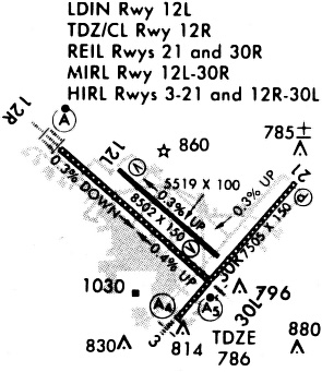
Runways
Runway Summary
| Runways: | 04/22 13L/31R 13R/31L |
| Longest Runway: | 04/22 is 8505 ft (2592 m) long |
| Runways with an Instrument Approach: | 04, 13R, 31L |
SAT Airport Runway Details
| Runway 04/22 | 8505 ft x 150 ft (2592 m x 46 m) | |
| Runway Length Source: | 3RD PARTY SURVEY as of 10/28/2019 | |
| Surface: | Concrete - Good condition - Saw-cut or plastic grooved | |
| Runway Pavement Class: | 91 /R/B/W/T | |
| Runway Edge Lights: | High Intensity | |
Runway Weight Bearing Capacity (in thousands of pounds) |
||
| Single Wheel Landing Gear: | 95.0 | |
| Dual Wheel Landing Gear: | 190.0 | |
| Dual Tandem Wheel Landing Gear: | 270.0 | |
Runway 04 |
Runway 22 |
|
Elevation: |
786.0 | 754.5 |
Latitude: |
29-31-23.6409N | 29-32-27.3928N |
Longitude: |
098-28-11.6562W | 098-27-08.7715W |
|
Runway True Alignment: |
041 | 221 |
ILS Type: |
ILS/DME | |
Glide Path Angle: |
3.0 degrees | 3.0 degrees |
Traffic Pattern: |
Left | Left |
Runway Markings Type: |
Precision Instrument | Precision Instrument |
Runway Markings Condition: |
Good | Good |
Object at End: |
POLE | |
Object Height: |
46 | |
Object Marked/Lighted?: |
Lighted | |
Distance from End: |
2180 | |
Object Centerline Offset: |
225 ft. left of centerline | |
Visual Glide Slope Indicators: |
4-Light PAPI On Right Side Of Runway | 4-Light PAPI On Left Side Of Runway |
Runway Visual Range (RVR): |
Touchdown | Rollout |
Approach Light System: |
1,400 Foot Medium Intensity Approach Lighting System | |
REIL: |
Yes | |
Touchdown Lights: |
No | No |
Centerline Lights: |
Yes | Yes |
Threshold Crossing Height: |
79 | 85 |
Declared Distances |
||
Take Off Run Avbl. (TORA): |
8505 | 8505 |
Take Off Distance Avbl. (TODA): |
8505 | 8505 |
Actual Stop Dist. Avbl. (ASDA): |
8505 | 8505 |
Landing Dist. Avbl. (LDA): |
8505 | 8505 |
| Runway 13L/31R | 5519 ft x 100 ft (1682 m x 30 m) | |
| Runway Length Source: | 3RD PARTY SURVEY as of 10/28/2019 | |
| Surface: | Concrete - Good condition - No special surface treatment | |
| Runway Pavement Class: | 61 /F/C/W/T | |
| Runway Edge Lights: | Medium Intensity | |
Runway Weight Bearing Capacity (in thousands of pounds) |
||
| Single Wheel Landing Gear: | 59.0 | |
| Dual Wheel Landing Gear: | 120.0 | |
Runway 13L |
Runway 31R |
|
Elevation: |
797.3 | 779.2 |
Latitude: |
29-32-25.0764N | 29-31-48.7812N |
Longitude: |
098-28-39.7140W | 098-27-53.0202W |
|
Runway True Alignment: |
132 | 312 |
Glide Path Angle: |
3.0 degrees | 3.0 degrees |
Traffic Pattern: |
Left | Left |
Runway Markings Type: |
Nonprecision Instrument | Basic |
Runway Markings Condition: |
Good | Good |
Object Centerline Offset: |
225 ft. left of centerline | |
Visual Glide Slope Indicators: |
4-Light PAPI On Left Side Of Runway | 4-Light PAPI On Left Side Of Runway |
REIL: |
Yes | Yes |
Threshold Crossing Height: |
40 | 60 |
Declared Distances |
||
Take Off Run Avbl. (TORA): |
5519 | 5519 |
Take Off Distance Avbl. (TODA): |
5519 | 5519 |
Actual Stop Dist. Avbl. (ASDA): |
5519 | 5519 |
Landing Dist. Avbl. (LDA): |
5519 | 5519 |
| Runway 13R/31L | 8502 ft x 150 ft (2591 m x 46 m) | |
| Runway Length Source: | 3RD PARTY SURVEY as of 10/28/2019 | |
| Surface: | Concrete - Good condition - Saw-cut or plastic grooved | |
| Runway Pavement Class: | 86 /R/B/W/T | |
| Runway Edge Lights: | High Intensity | |
Runway Weight Bearing Capacity (in thousands of pounds) |
||
| Single Wheel Landing Gear: | 95.0 | |
| Dual Wheel Landing Gear: | 190.0 | |
| Dual Tandem Wheel Landing Gear: | 270.0 | |
Runway 13R |
Runway 31L |
|
Elevation: |
809.1 | 778.5 |
Latitude: |
29-32-33.8853N | 29-31-38.0038N |
Longitude: |
098-29-07.9481W | 098-27-55.9932W |
|
Runway True Alignment: |
132 | 312 |
ILS Type: |
ILS/DME | ILS/DME |
Glide Path Angle: |
3.0 degrees | 3.0 degrees |
Traffic Pattern: |
Left | Left |
Runway Markings Type: |
Precision Instrument | Precision Instrument |
Runway Markings Condition: |
Good | Good |
Object at End: |
BLDG | |
Object Height: |
79 | |
Distance from End: |
3500 | |
Object Centerline Offset: |
225 ft. left of centerline | |
Visual Glide Slope Indicators: |
4-Light PAPI On Left Side Of Runway | 4-Light PAPI On Left Side Of Runway |
Runway Visual Range (RVR): |
Touchdown, Midfield, Rollout | Touchdown, Midfield, Rollout |
Approach Light System: |
Standard 2,400 Foot High Intensity Approach Lighting System With Sequenced Flashers, Cat. II or III Config. | 1,400 Foot Medium Intensity Approach Lighting System With Runway Alignment Indicator Lights |
Touchdown Lights: |
Yes | No |
Centerline Lights: |
Yes | Yes |
Threshold Crossing Height: |
75 | 82 |
Declared Distances |
||
Take Off Run Avbl. (TORA): |
8502 | 8502 |
Take Off Distance Avbl. (TODA): |
8502 | 8502 |
Actual Stop Dist. Avbl. (ASDA): |
8502 | 8502 |
Landing Dist. Avbl. (LDA): |
8502 | 8502 |
Services
Bottled Oxygen: |
None |
Bulk Oxygen: |
None |
Fuel Available: |
100LL |
Landing Fees: |
No |
Parking: |
Tiedowns available |
Maps & Diagrams
SAT Sectional
Flight Planning
at skyvector.com
at skyvector.com