Location
Latitude: |
43-54-43.7000N (43.912139) |
Longitude: |
114-47-45.8000W (-114.796056) |
Elevation: |
7206.0 feet MSL (2196 m MSL) |
Magnetic Variation: |
12.5 E (as of April 2024 from WMM2020 model) |
Time Zone: |
UTC -7.0 (Standard Time) UTC -6.0 (Daylight Savings Time) |
From City: |
00 N.M. E of Smiley Creek, Idaho |
Found On: |
Salt Lake City Chart |
FAA Region: |
ANM |
Contacts
Manager: |
Publicly owned: |
| IDAHO DIV OF AERONAUTICS P O BOX 7129 BOISE, ID 83707-1129 208-334-8775 |
STATE OF ID, ITD DIV AERO P O BOX 7129 BOISE, ID 83707-1129 208-334-8775 |
Operations
Airport Status: |
Operational |
Facility Use: |
Public |
Type: |
Airport |
Activation Date: |
06/1966 |
Control tower: |
No |
Attendance (Months/Days/Hours): |
Months/Days/Hours Unattended |
Boundary ARTCC: |
ZLC (Salt Lake City) |
Responsible ARTCC: |
ZLC (Salt Lake City) |
Segmented Circle Indicator: |
Yes |
Traffic Pattern Altitude (MSL): |
8206 feet (2501 m) |
NOTAMs Facility: |
BOI |
NOTAM-D Service: |
Yes |
International Airport of Entry: |
No |
Customs Landing Rights: |
No |
Civil/Military Joint Use: |
No |
Based Aircraft
Annual Operations (as of 07/30/2022)
| Total Operations: | 5100 | |
| Air Taxi: | 400 | 7.8% |
| GA Itinerant: | 4700 | 92.2% |
Communications
| CTAF: | 122.900 |
Fixed Based Operators (FBOs) & Fuel
(Click on a business for detail)
Please help us keep this information up to date. This is a FREE SERVICE just like everything else on Airport Guide! If you see that a business needs to be added, modified, or deleted please fill out our Update Form.
To add, modify, or delete a business click here.
Please help us keep this information up to date. This is a FREE SERVICE just like everything else on Airport Guide! If you see that a business needs to be added, modified, or deleted please fill out our Update Form.
| Business Name | Frequency | Phone | Fuel Grade |
|---|
Flight Service Stations
| Primary | Alternate | |
| FSS on Field: | N | |
| FSS Name (ID): | Boise(BOI) | |
| Frequency: | ||
| Toll Free Phone: | 1-800-WX-BRIEF |
Instrument Procedures / Charts
Terminal Procedures are only available for airports in several countries with more being added all the time. If you are looking for a specific country's charts, please send an email to support(at)airportguide.com stating the country name. This will be used to prioritize the implementation.
Navigation Aids (Navaids) near U87
| Dist (NM) | ID | Morse Code | Name | Type | Freq | True Hdg | Mag Hdg |
|---|---|---|---|---|---|---|---|
| 42.4 | HLE | . . . . . _ . . . | Hailey | NDB-DME | 220 | 145 | 133 |
| 60.0 | HDG | . . . . _ . . _ _ . | Steelhead | NDB | 211 | 174 | 162 |
| 60.9 | STI | . . . _ . . | Sturgeon | NDB | 333 | 218 | 205 |
| 64.2 | BOI | _ . . . _ _ _ . . | Boise | VORTAC | 113.30 | 250 | 237 |
| 65.3 | BOI | _ . . . _ _ _ . . | Boise | VOT | 116.70 | 251 | 238 |
| 68.5 | BO | _ . . . _ _ _ | Ustik | NDB | 359 | 254 | 241 |
| 70.2 | LIA | . _ . . . . . _ | Liberator | VOR | 114.90 | 217 | 204 |
| 70.3 | MUO | _ _ . . _ _ _ _ | Mountain Home | TACAN | 114.00 | 222 | 209 |
| 73.2 | LKT | . _ . . _ . _ _ | Salmon | VOR-DME | 113.50 | 24 | 12 |
| 77.8 | MPA | _ _ . _ _ . . _ | Meridian | NDB | 238 | 256 | 243 |
| 79.3 | DNJ | _ . . _ . . _ _ _ | Donnelly | VOR-DME | 116.20 | 310 | 297 |
| 87.0 | TWF | _ . _ _ . . _ . | Twin Falls | VORTAC | 113.10 | 171 | 159 |
| 88.2 | TW | _ . _ _ | Strik | NDB | 389 | 167 | 155 |
| 89.7 | BYI | _ . . . _ . _ _ . . | Burley | VOR-DME | 114.10 | 152 | 140 |
| 95.8 | ONO | _ _ _ _ . _ _ _ | Ontario | NDB | 305 | 274 | 261 |
Nearby Airports with Fuel
Notices to Airmen (NOTAMS)
Remarks
| A10 | PRIVATE LAND LEASED TO THE IDAHO DIVISION OF AERONAUTICS. |
| A110-1 | NO WINTER MAINTENANCE. |
| A110-2 | RECOMMEND LNDG RY 14 TKOF RY 32 WHEN WIND CONDITIONS ALLOW. |
| A110-3 | BE ALERT FOR SPRINKLERS/STAND PIPES ON EDGE OF RY. |
| A110-4 | ARPT LCTD IN VALLEY SURROUNDED BY HIGH MOUNTAINOUS TERRAIN. |
| A110-6 | EXTREMELY HIGH DENSITY ALTITUDE CONDITIONS EXIST DURING SUMMER MONTHS. |
| A110-7 | FOR CD CTC SALT LAKE ARTCC AT 801-320-2568. |
| A42-14 | 14/32 EDGES & THRS MKD WITH WHITE ROCK BOUNDARY MKRS. |
| A52-14 | 4 FT FENCE 200 FT ON CNTRLN, +3 FT BERM & CREEK 60 FT ON CNTRLN. |
| A52-32 | RWY 32 5 FT FENCE 200 FT ON CNTRLN, +2 FT BERM 60 FT ON CNTRLN, 15FT BRUSH 75 FT 100 FT L, +2 FT SPRINKLER VALVE 50 FT 35 FT L. |
Runways
Runway Summary
| Runways: | 14/32 |
| Longest Runway: | 14/32 is 4900 ft (1494 m) long |
| Runways with an Instrument Approach: |
U87 Airport Runway Details
| Runway 14/32 | 4900 ft x 150 ft (1494 m x 46 m) | |
| Surface: | Turf - Excellent condition - No special surface treatment | |
Runway 14 |
Runway 32 |
|
Latitude: |
43-55-05.7000N | 43-54-21.7600N |
Longitude: |
114-47-59.8200W | 114-47-31.7400W |
Glide Path Angle: |
0.0 degrees | 0.0 degrees |
Traffic Pattern: |
Left | Left |
Object at End: |
FENCE | FENCE |
Object Height: |
4 | 5 |
Distance from End: |
0 | 0 |
Object Centerline Offset: |
100 ft. left of centerline | 100 ft. right of centerline |
Services
Airframe Repair: |
Major |
Powerplant Repair: |
Major |
Bottled Oxygen: |
None |
Fuel Available: |
100LL, Jet A |
Landing Fees: |
No |
Parking: |
Tiedowns available |
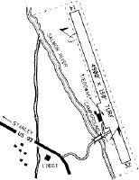
Maps & Diagrams
U87 Sectional
Flight Planning
at skyvector.com
at skyvector.com