Location
Latitude: |
43-10-10.7000N (43.169639) |
Longitude: |
088-43-23.6000W (-88.723222) |
Elevation: |
832.9 feet MSL (254 m MSL) |
Magnetic Variation: |
3.5 W (as of April 2024 from WMM2020 model) |
Time Zone: |
UTC -6.0 (Standard Time) UTC -5.0 (Daylight Savings Time) |
From City: |
00 N.M. S of Watertown, Wisconsin |
Found On: |
Chicago Chart |
FAA Region: |
AGL |
Contacts
Manager: |
Publicly owned: |
| JEFF BAUM 1741 RIVER DRIVE WATERTOWN, WI 53094 920-261-4567 |
CITY OF WATERTOWN 106 JONES WATERTOWN, WI 53094 920-262-4000 |
Operations
Airport Status: |
Operational |
Facility Use: |
Public |
Type: |
Airport |
Activation Date: |
12/1945 |
Control tower: |
No |
Attendance (Months/Days/Hours): |
Months/Days/Hours ALL/SAT-SUN/0700-2000 |
Boundary ARTCC: |
ZAU (Chicago) |
Responsible ARTCC: |
ZAU (Chicago) |
Lighting Schedule: |
SEE RMK |
Segmented Circle Indicator: |
Yes |
Traffic Pattern Altitude (MSL): |
1833 feet (559 m) |
NOTAMs Facility: |
RYV |
NOTAM-D Service: |
Yes |
International Airport of Entry: |
No |
Customs Landing Rights: |
No |
Military Landing Rights: |
Yes |
Civil/Military Joint Use: |
No |
Based Aircraft
| Single Engine: | 51 |
| Multi Engine: | 7 |
| Jet Engine: | 2 |
Annual Operations (as of 05/24/2021)
| Total Operations: | 58000 | |
| Air Taxi: | 5500 | 9.5% |
| GA Local: | 35000 | 60.3% |
| GA Itinerant: | 16500 | 28.4% |
| Military Aircraft: | 1000 | 1.7% |
Communications
| CTAF: | 122.800 |
| Unicom: | 122.800 |
| Approach: | MADISON 119.15 119.15 CHICAGO ARTCC |
| Departure: | MADISON 119.15 119.15 CHICAGO ARTCC |
| AWOS-3: | 119.975 (920-261-0734) |
- APCH/DEP SVC PRVDD BY CHICAGO ARTCC ON FREQS 133.3/257.925 (LONE ROCK RCAG) WHEN MADISON APCH CTL CLSD.
Fixed Based Operators (FBOs) & Fuel
(Click on a business for detail)
Please help us keep this information up to date. This is a FREE SERVICE just like everything else on Airport Guide! If you see that a business needs to be added, modified, or deleted please fill out our Update Form.
To add, modify, or delete a business click here.
Please help us keep this information up to date. This is a FREE SERVICE just like everything else on Airport Guide! If you see that a business needs to be added, modified, or deleted please fill out our Update Form.
Area Code: 920 |
| Business Name | Frequency | Phone | Fuel Grade |
|---|---|---|---|
| Central Aviation, Inc.
Update FBO info |
261-1880 | ||
| Wisconsin Aviation-Watertown
Update FBO info |
Unicom 122.8 | 800-657-0761, 261-4567 | 100LL, Jet A |
Flight Service Stations
| Primary | Alternate | |
| FSS on Field: | N | |
| FSS Name (ID): | Green Bay(GRB) | |
| Frequency: | ||
| Toll Free Phone: | 1-800-WX-BRIEF |
Instrument Procedures / Charts
FAA Terminal Procedures valid from 0901Z 03/21/24 to 0901Z 04/18/24.
There are various types of charts available for an airport. They are listed in the Page Type column. Here is a legend for those types:
APD - Airport Diagram
DP - Departure Procedure Charts
HOT - Hot Spots
IAP - Instrument Approach Procedure Charts
MIN - Minimums
STAR - Standard Terminal Arrival Charts
| Page Type | Page Name | Volume | Action Since Last Cycle |
|---|---|---|---|
| IAP | NDB RWY 05 | EC-3 | |
| IAP | NDB RWY 23 | EC-3 | |
| IAP | RNAV (GPS) RWY 05 | EC-3 | |
| IAP | RNAV (GPS) RWY 11 | EC-3 | |
| IAP | RNAV (GPS) RWY 23 | EC-3 | |
| IAP | RNAV (GPS) RWY 29 | EC-3 | |
| MIN | ALTERNATE MINIMUMS | EC-3 | |
| MIN | TAKEOFF MINIMUMS | EC-3 |
Terminal Procedures are only available for airports in several countries with more being added all the time. If you are looking for a specific country's charts, please send an email to support(at)airportguide.com stating the country name. This will be used to prioritize the implementation.
Navigation Aids (Navaids) near KRYV
| Dist (NM) | ID | Morse Code | Name | Type | Freq | True Hdg | Mag Hdg |
|---|---|---|---|---|---|---|---|
| 0.3 | RYV | . _ . _ . _ _ . . . _ | Rock River | NDB | 371 | 339 | 343 |
| 15.6 | UNU | . . _ _ . . . _ | Juneau | NDB | 344 | 3 | 7 |
| 19.5 | BAE | _ . . . . _ . | Badger | VOR-DME | 116.40 | 99 | 103 |
| 27.0 | MSN | _ _ . . . _ . | Madison | VORTAC | 108.60 | 267 | 270 |
| 28.0 | MS | _ _ . . . | Monah | NDB | 400 | 256 | 259 |
| 28.8 | LVV | . _ . . . . . _ . . . _ | Lake Lawn | NDB | 404 | 168 | 172 |
| 30.2 | BJB | _ . . . . _ _ _ _ . . . | West Bend | VOR | 109.80 | 59 | 63 |
| 30.2 | LJT | . _ . . . _ _ _ _ | Timmerman | DME | 115.65 | 96 | 100 |
| 33.8 | GM | _ _ . _ _ | Teels | NDB | 242 | 117 | 121 |
| 34.3 | BUU | _ . . . . . _ . . _ | Burbun | DME | 114.5 | 147 | 151 |
| 36.1 | JVL | . _ _ _ . . . _ . _ . . | Janesville | NDB | 375 | 202 | 205 |
| 37.7 | BL | _ . . . . _ . . | Yanks | NDB | 260 | 99 | 103 |
| 38.6 | MKE | _ _ _ . _ . | Milwaukee | VOT | 109.00 | 109 | 113 |
| 40.4 | JVL | . _ _ _ . . . _ . _ . . | Janesville | VOR-DME | 114.30 | 204 | 207 |
| 42.9 | OS | _ _ _ . . . | Pober | NDB | 395 | 9 | 13 |
| 46.5 | RA | . _ . . _ | Paser | NDB | 206 | 128 | 132 |
| 46.8 | HRK | . . . . . _ . _ . _ | Horlick | DME | 114.05 | 121 | 125 |
| 47.6 | EN | . _ . | Codee | NDB | 389 | 139 | 143 |
| 48.8 | ENW | . _ . . _ _ | Kenosha | DME | 109.2 | 134 | 138 |
| 49.8 | OSH | _ _ _ . . . . . . . | Oshkosh | VORTAC | 116.75 | 8 | 12 |
Nearby Airports with Fuel
Notices to Airmen (NOTAMS)
Remarks
| A110*G | THIS AIRPORT HAS BEEN SURVEYED BY THE NATIONAL GEODETIC SURVEY. |
| A110-1 | DEER ON & INVOF ARPT. |
| A110-2 | DUCKS & SEAGULLS OCCASSIONALLY NEAR ARPT DURING SEASONAL MIGRATIONS. |
| A110-3 | FOR CD CTC MADISON APP/DEP CON AT 608-249-8240. WHEN MADISON APCH CLSD, FOR CD CTC CHICAGO ARTCC AT 630-906-8921. |
| A17 | ARPT ATTENDED OTHER HRS ON REQUEST THRU FBO. |
| A57-05 | APCH RATIO 23:1 TO DSPLCD THR. |
| A81-APT | ACTVT MIRL RYS 05/23 & 11/29, PAPI RYS 05 & 23 & REIL RYS 05 & 23 - CTAF. |
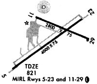
Runways
Runway Summary
| Runways: | 05/23 11/29 |
| Longest Runway: | 05/23 is 4429 ft (1350 m) long |
| Runways with an Instrument Approach: |
KRYV Airport Runway Details
| Runway 05/23 | 4429 ft x 75 ft (1350 m x 23 m) | |
| Runway Length Source: | NGS as of 08/20/2007 | |
| Surface: | Asphalt - Fair condition - No special surface treatment | |
| Runway Edge Lights: | Medium Intensity | |
Runway Weight Bearing Capacity (in thousands of pounds) |
||
| Single Wheel Landing Gear: | 30.0 | |
| Dual Wheel Landing Gear: | 60.0 | |
Runway 05 |
Runway 23 |
|
Elevation: |
817.4 | 822.9 |
Latitude: |
43-09-54.7873N | 43-10-20.9948N |
Longitude: |
088-43-50.7650W | 088-43-02.9206W |
|
Runway True Alignment: |
053 | 233 |
Glide Path Angle: |
3.0 degrees | 3.0 degrees |
Traffic Pattern: |
Right | Left |
Runway Markings Type: |
Nonprecision Instrument | Nonprecision Instrument |
Runway Markings Condition: |
Fair | Fair |
Object at End: |
TREE | TREE |
Object Height: |
40 | 76 |
Distance from End: |
950 | 1450 |
Object Centerline Offset: |
15 ft. right of centerline | 400 ft. right of centerline |
Visual Glide Slope Indicators: |
2-Light PAPI On Left Side Of Runway | 2-Light PAPI On Left Side Of Runway |
REIL: |
Yes | Yes |
Threshold Crossing Height: |
50 | 45 |
Threshold Elevation: |
818.4 | |
Displaced Threshold: |
190 | |
Threshold Latitude: |
43-09-55.9099N | |
Threshold Longitude: |
088-43-48.7160W | |
Declared Distances |
||
Take Off Run Avbl. (TORA): |
4430 | 4430 |
Take Off Distance Avbl. (TODA): |
5110 | 4845 |
Actual Stop Dist. Avbl. (ASDA): |
4550 | 4430 |
Landing Dist. Avbl. (LDA): |
4430 | 4430 |
| Runway 11/29 | 2801 ft x 75 ft (854 m x 23 m) | |
| Runway Length Source: | NGS as of 08/20/2007 | |
| Surface: | Asphalt - Fair condition - No special surface treatment | |
| Runway Edge Lights: | Medium Intensity | |
Runway Weight Bearing Capacity (in thousands of pounds) |
||
| Single Wheel Landing Gear: | 30.0 | |
Runway 11 |
Runway 29 |
|
Elevation: |
822.8 | 832.9 |
Latitude: |
43-10-20.2408N | 43-10-09.9189N |
Longitude: |
088-43-35.9156W | 088-43-00.8560W |
|
Runway True Alignment: |
112 | 292 |
Glide Path Angle: |
0.0 degrees | 0.0 degrees |
Traffic Pattern: |
Right | |
Runway Markings Type: |
Nonprecision Instrument | Nonprecision Instrument |
Runway Markings Condition: |
Fair | Fair |
Object at End: |
TREES | TREE |
Object Height: |
42 | 64 |
Distance from End: |
900 | 1100 |
Object Centerline Offset: |
15 ft. right of centerline | 400 ft. right of centerline |
Services
Airframe Repair: |
None |
Powerplant Repair: |
None |
Bottled Oxygen: |
None |
Bulk Oxygen: |
None |
Fuel Available: |
100LL |
Landing Fees: |
No |
Parking: |
Hangars and tiedowns available |
Maps & Diagrams
KRYV Sectional
Flight Planning
at skyvector.com
at skyvector.com