Location
Latitude: |
42-45-40.2490N (42.76118) |
Longitude: |
087-48-50.0740W (-87.813909) |
Elevation: |
673.6 feet MSL (205 m MSL) |
Magnetic Variation: |
4.1 W (as of April 2024 from WMM2020 model) |
Time Zone: |
UTC -6.0 (Standard Time) UTC -5.0 (Daylight Savings Time) |
From City: |
02 N.M. NW of Racine, Wisconsin |
Found On: |
Chicago Chart |
FAA Region: |
AGL |
Contacts
Manager: |
Privately owned: |
| TAMARA SANDBERG 3239 N. GREEN BAY RD RACINE, WI 53404 262-631-5620 |
RACINE COMMERCIAL APRT CORP. 3239 N. GREEN BAY RD RACINE, WI 53404 262-631-5620 |
Operations
Airport Status: |
Operational |
Facility Use: |
Public |
Type: |
Airport |
Activation Date: |
01/1941 |
Control tower: |
No |
Attendance (Months/Days/Hours): |
Months/Days/Hours ALL/MON-FRI/0700-1700 |
Boundary ARTCC: |
ZAU (Chicago) |
Responsible ARTCC: |
ZAU (Chicago) |
Lighting Schedule: |
SEE RMK |
Segmented Circle Indicator: |
No |
Traffic Pattern Altitude (MSL): |
1674 feet (510 m) |
NOTAMs Facility: |
RAC |
NOTAM-D Service: |
Yes |
International Airport of Entry: |
No |
Customs Landing Rights: |
Yes |
Military Landing Rights: |
No |
Civil/Military Joint Use: |
No |
Based Aircraft
| Single Engine: | 64 |
| Multi Engine: | 6 |
| Jet Engine: | 5 |
| GA Helicopters: | 2 |
| Ultralights: | 1 |
Annual Operations (as of 06/15/2021)
| Total Operations: | 47000 | |
| Air Taxi: | 2000 | 4.3% |
| GA Local: | 25000 | 53.2% |
| GA Itinerant: | 20000 | 42.6% |
Communications
| CTAF: | 123.075 |
| Unicom: | 123.075 |
| Clearance Del.: | 120.15 120.15 120.15 120.15 120.15 |
| Approach: | MILWAUKEE |
| Departure: | MILWAUKEE |
| ASOS: | 121.425 (262-635-0959) |
Fixed Based Operators (FBOs) & Fuel
(Click on a business for detail)
Please help us keep this information up to date. This is a FREE SERVICE just like everything else on Airport Guide! If you see that a business needs to be added, modified, or deleted please fill out our Update Form.
To add, modify, or delete a business click here.
Please help us keep this information up to date. This is a FREE SERVICE just like everything else on Airport Guide! If you see that a business needs to be added, modified, or deleted please fill out our Update Form.
Area Code: 262 |
| Business Name | Frequency | Phone | Fuel Grade |
|---|---|---|---|
| Racine Commercial Airport Corp
Update FBO info |
Unicom 123.075 | 631-5620 | 80, 100LL, Jet A |
Flight Service Stations
| Primary | Alternate | |
| FSS on Field: | N | |
| FSS Name (ID): | Green Bay(GRB) | |
| Frequency: | ||
| Toll Free Phone: | 1-800-WX-BRIEF |
Instrument Procedures / Charts
FAA Terminal Procedures valid from 0901Z 03/21/24 to 0901Z 04/18/24.
There are various types of charts available for an airport. They are listed in the Page Type column. Here is a legend for those types:
APD - Airport Diagram
DP - Departure Procedure Charts
HOT - Hot Spots
IAP - Instrument Approach Procedure Charts
MIN - Minimums
STAR - Standard Terminal Arrival Charts
| Page Type | Page Name | Volume | Action Since Last Cycle |
|---|---|---|---|
| DP | ACCRA FIVE (RNAV) | EC-3 | |
| DP | UECKR SIX (RNAV) | EC-3 | |
| IAP | ILS OR LOC RWY 04 | EC-3 | |
| IAP | RNAV (GPS) RWY 04 | EC-3 | |
| IAP | RNAV (GPS) RWY 22 | EC-3 | |
| IAP | RNAV (GPS) RWY 32 | EC-3 | |
| MIN | ALTERNATE MINIMUMS | EC-3 | |
| MIN | TAKEOFF MINIMUMS | EC-3 | |
| STAR | GOPAC THREE (RNAV) | EC-3 |
Terminal Procedures are only available for airports in several countries with more being added all the time. If you are looking for a specific country's charts, please send an email to support(at)airportguide.com stating the country name. This will be used to prioritize the implementation.
Navigation Aids (Navaids) near RAC
| Dist (NM) | ID | Morse Code | Name | Type | Freq | True Hdg | Mag Hdg |
|---|---|---|---|---|---|---|---|
| 0.1 | HRK | . . . . . _ . _ . _ | Horlick | DME | 114.05 | 330 | 334 |
| 6.0 | RA | . _ . . _ | Paser | NDB | 206 | 218 | 222 |
| 11.0 | ENW | . _ . . _ _ | Kenosha | DME | 109.2 | 208 | 212 |
| 11.8 | MKE | _ _ _ . _ . | Milwaukee | VOT | 109.00 | 342 | 346 |
| 13.4 | GM | _ _ . _ _ | Teels | NDB | 242 | 311 | 315 |
| 15.3 | EN | . _ . | Codee | NDB | 389 | 218 | 222 |
| 17.8 | UG | . . _ _ _ . | Wauke | NDB | 379 | 178 | 182 |
| 18.1 | BL | _ . . . . _ . . | Yanks | NDB | 260 | 351 | 355 |
| 21.9 | BUU | _ . . . . . _ . . _ | Burbun | DME | 114.5 | 258 | 262 |
| 23.1 | LJT | . _ . . . _ _ _ _ | Timmerman | DME | 115.65 | 334 | 338 |
| 29.7 | BAE | _ . . . . _ . | Badger | VOR-DME | 116.40 | 316 | 320 |
| 33.0 | OBK | _ _ _ _ . . . _ . _ | Northbrook | VOR-DME | 113.00 | 190 | 194 |
| 34.5 | LVV | . _ . . . . . _ . . . _ | Lake Lawn | NDB | 404 | 264 | 268 |
| 41.9 | BJB | _ . . . . _ _ _ _ . . . | West Bend | VOR | 109.80 | 341 | 345 |
| 46.2 | GCO | _ _ . _ . _ . _ _ _ | Chicago | DME | 108.25 | 184 | 188 |
| 46.6 | ORD | _ _ _ . _ . _ . . | Chicago O'hare | VOR-DME | 113.90 | 184 | 188 |
| 47.1 | RYV | . _ . _ . _ _ . . . _ | Rock River | NDB | 371 | 302 | 306 |
| 48.5 | ME | _ _ . | Deana | NDB | 350 | 191 | 195 |
| 54.8 | JVL | . _ _ _ . . . _ . _ . . | Janesville | NDB | 375 | 261 | 265 |
| 55.9 | UNU | . . _ _ . . . _ | Juneau | NDB | 344 | 316 | 320 |
Nearby Airports with Fuel
Notices to Airmen (NOTAMS)
Remarks
| A110-1 | MIGRATORY WATERFOWL ON & INVOF ARPT. |
| A110-2 | FOR CD CTC CHICAGO ARTCC AT 630-906-8921. |
| A24 | LNDG FEE FOR JET ACFT. |
| A57-04 | APCH RATIO 38:1 TO DSPLCD THR; 29 FT TREE 1100 FT FM DSPLCD THR; 350 FT R. |
| A57-14 | APCH RATIO 16:1 TO DSPLCD THLD; 58 FT TREE 900 FT FM DSPLCD THR; 150 FT R. |
| A57-22 | APCH RATIO 21:1 TO DSPLCD THR; 29 FT TREE 615 FT FM DSPCLD THR; 65 FT R. |
| A58-04 | 10 FT FENCE 40 TO 80 FT FM RWY END BOTH SIDES OF CNTRLN; 15 FT RD 0 TO 200 FT FM RWY END BOTH SIDES OF CNTRLN. |
| A58-14 | 10 FT FENCE 0 TO 200 FT FM RWY END BOTH SIDES OF CNTRLN; 15 FT RD 0 TO 200 FT FM RWY END BOTH SIDES OF CNTRLN; 58 FT TREE 80 FT FM RWY END; 175 FT R. |
| A58-22 | 60 FT RR 0 TO 200 FT FM RWY END; 60 TO 230 FT L; 20 FT TREE 10 FT FM RWY END; 130 FT L. |
| A81-APT | ACTVT HIRL RY 04/22 & MIRL RY 14/32; PAPI RY 14; REIL RYS 22, 14 & 32; MALSF RY 04 - CTAF. PAPI RYS 04 & 22 OPERS 24 HRS. |
| E111 | EST PRIOR TO 1959. |
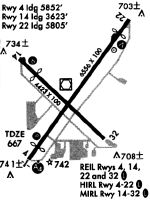
Runways
Runway Summary
| Runways: | 04/22 14/32 |
| Longest Runway: | 04/22 is 6574 ft (2004 m) long |
| Runways with an Instrument Approach: | 04 |
RAC Airport Runway Details
| Runway 04/22 | 6574 ft x 100 ft (2004 m x 30 m) | |
| Runway Length Source: | 3RD PARTY SURVEY as of 03/20/2022 | |
| Surface: | Concrete - Good condition - Saw-cut or plastic grooved | |
| Runway Pavement Class: | 18 /R/B/W/T | |
| Runway Edge Lights: | High Intensity | |
Runway Weight Bearing Capacity (in thousands of pounds) |
||
| Single Wheel Landing Gear: | 50.0 | |
| Dual Wheel Landing Gear: | 65.0 | |
Runway 04 |
Runway 22 |
|
Elevation: |
672.4 | 665.0 |
Latitude: |
42-45-15.6555N | 42-46-07.5607N |
Longitude: |
087-49-13.3664W | 087-48-20.4136W |
|
Runway True Alignment: |
037 | 217 |
ILS Type: |
ILS | |
Glide Path Angle: |
3.0 degrees | 3.0 degrees |
Traffic Pattern: |
Left | Left |
Runway Markings Type: |
Precision Instrument | Precision Instrument |
Runway Markings Condition: |
Good | Good |
Object at End: |
ROAD | RR |
Object Height: |
6 | 8 |
Distance from End: |
200 | 200 |
Object Centerline Offset: |
140 ft. right of centerline | 50 ft. left of centerline |
Visual Glide Slope Indicators: |
4-Light PAPI On Left Side Of Runway | 4-Light PAPI On Left Side Of Runway |
Approach Light System: |
1,400 Foot Medium Intensity Approach Lighting System With Sequenced Flashers | |
REIL: |
No | Yes |
Touchdown Lights: |
No | No |
Centerline Lights: |
No | No |
Threshold Crossing Height: |
45 | 46 |
Threshold Elevation: |
667.7 | 665.4 |
Displaced Threshold: |
734 | 390 |
Threshold Latitude: |
42-45-21.4514N | 42-46-04.4841N |
Threshold Longitude: |
087-49-07.4553W | 087-48-23.5520W |
| Runway 14/32 | 4421 ft x 100 ft (1348 m x 30 m) | |
| Runway Length Source: | 3RD PARTY SURVEY as of 03/20/2022 | |
| Surface: | Concrete - Good condition - No special surface treatment | |
| Runway Edge Lights: | Medium Intensity | |
Runway Weight Bearing Capacity (in thousands of pounds) |
||
| Single Wheel Landing Gear: | 25.0 | |
| Dual Wheel Landing Gear: | 35.0 | |
Runway 14 |
Runway 32 |
|
Elevation: |
673.6 | 658.2 |
Latitude: |
42-45-53.2023N | 42-45-23.2506N |
Longitude: |
087-49-16.3663W | 087-48-33.2451W |
|
Runway True Alignment: |
133 | 313 |
Glide Path Angle: |
4.0 degrees | 0.0 degrees |
Traffic Pattern: |
Left | Left |
Runway Markings Type: |
Nonprecision Instrument | Nonprecision Instrument |
Runway Markings Condition: |
Good | Good |
Object at End: |
ROAD | TREE |
Object Height: |
15 | 31 |
Distance from End: |
200 | 770 |
Object Centerline Offset: |
140 ft. right of centerline | 50 ft. left of centerline |
Visual Glide Slope Indicators: |
4-Light PAPI On Left Side Of Runway | |
REIL: |
Yes | Yes |
Touchdown Lights: |
No | No |
Centerline Lights: |
No | No |
Threshold Crossing Height: |
55 | |
Threshold Elevation: |
669.9 | |
Displaced Threshold: |
807 | |
Threshold Latitude: |
42-45-47.7399N | |
Threshold Longitude: |
087-49-08.4882W |
Services
Airframe Repair: |
Major |
Powerplant Repair: |
Major |
Bulk Oxygen: |
Low Pressure |
Fuel Available: |
100LL, Jet A |
Landing Fees: |
No |
Parking: |
Hangars and tiedowns available |
Maps & Diagrams
RAC Sectional
Flight Planning
at skyvector.com
at skyvector.com