Location
Latitude: |
47-19-32.9200N (47.325811) |
Longitude: |
116-34-36.0400W (-116.576678) |
Elevation: |
2131.3 feet MSL (650 m MSL) |
Magnetic Variation: |
13.7 E (as of April 2024 from WMM2020 model) |
Time Zone: |
UTC -8.0 (Standard Time) UTC -7.0 (Daylight Savings Time) |
From City: |
01 N.M. NW of St. Maries, Idaho |
Found On: |
Great Falls Chart |
FAA Region: |
ANM |
Contacts
Manager: |
Publicly owned: |
| JIM ROLETTO 701 COLLEGE AVE ST MARIES, ID 83861 208-967-4232 |
BENEWAH COUNTY BENEWAH COUNTY COURTHOUSE ST MARIES, ID 83861 208-245-2234 |
Operations
Airport Status: |
Operational |
Facility Use: |
Public |
Type: |
Airport |
Activation Date: |
04/1940 |
Control tower: |
No |
Attendance (Months/Days/Hours): |
Months/Days/Hours Unattended |
Boundary ARTCC: |
ZSE (Seattle) |
Responsible ARTCC: |
ZSE (Seattle) |
Lighting Schedule: |
SEE RMK |
Segmented Circle Indicator: |
Yes |
Traffic Pattern Altitude (MSL): |
3131 feet (954 m) |
NOTAMs Facility: |
BOI |
NOTAM-D Service: |
Yes |
International Airport of Entry: |
No |
Customs Landing Rights: |
No |
Military Landing Rights: |
Yes |
Civil/Military Joint Use: |
No |
Based Aircraft
| Single Engine: | 13 |
| Multi Engine: | 2 |
Annual Operations (as of 07/30/2022)
| Total Operations: | 13100 | |
| GA Local: | 4700 | 35.9% |
| GA Itinerant: | 8400 | 64.1% |
Communications
| CTAF: | 122.800 |
| Unicom: | 122.800 |
Fixed Based Operators (FBOs) & Fuel
(Click on a business for detail)
Please help us keep this information up to date. This is a FREE SERVICE just like everything else on Airport Guide! If you see that a business needs to be added, modified, or deleted please fill out our Update Form.
To add, modify, or delete a business click here.
Please help us keep this information up to date. This is a FREE SERVICE just like everything else on Airport Guide! If you see that a business needs to be added, modified, or deleted please fill out our Update Form.
Area Code: 208 |
| Business Name | Frequency | Phone | Fuel Grade |
|---|---|---|---|
| Airport Management
Update FBO info |
245-4619 | 80, 100LL |
Flight Service Stations
| Primary | Alternate | |
| FSS on Field: | N | |
| FSS Name (ID): | Boise(BOI) | |
| Frequency: | ||
| Toll Free Phone: | 1-800-WX-BRIEF |
Instrument Procedures / Charts
Terminal Procedures are only available for airports in several countries with more being added all the time. If you are looking for a specific country's charts, please send an email to support(at)airportguide.com stating the country name. This will be used to prioritize the implementation.
Navigation Aids (Navaids) near S72
| Dist (NM) | ID | Morse Code | Name | Type | Freq | True Hdg | Mag Hdg |
|---|---|---|---|---|---|---|---|
| 28.6 | COE | _ . _ . _ _ _ . | Coeur D'alene | VOR-DME | 108.80 | 339 | 325 |
| 29.5 | LEN | . _ . . . _ . | Post Falls | NDB | 347 | 328 | 314 |
| 36.9 | SFF | . . . . . _ . . . _ . | Spokane/Felts Field | VOT | 114.00 | 305 | 291 |
| 38.6 | MLP | _ _ . _ . . . _ _ . | Mullan Pass | VOR-DME | 117.80 | 77 | 63 |
| 41.2 | CRK | _ . _ . . _ . _ . _ | Canyon | NDB | 388 | 301 | 287 |
| 42.3 | GEG | _ _ . . _ _ . | Spokane Intl | VOT | 109.60 | 294 | 280 |
| 45.0 | GEG | _ _ . . _ _ . | Spokane | VORTAC | 115.50 | 288 | 274 |
| 47.2 | PUW | . _ _ . . . _ . _ _ | Pullman | VOR-DME | 117.15 | 214 | 200 |
| 47.2 | SKA | . . . _ . _ . _ | Fairchild | TACAN | 111.40 | 291 | 277 |
| 51.6 | DPY | _ . . . _ _ . _ . _ _ | Deer Park | NDB | 365 | 318 | 304 |
| 57.9 | SZT | . . . _ _ . . _ | Sandpoe | NDB | 264 | 0 | 346 |
| 57.9 | MQG | _ _ _ _ . _ _ _ . | Nez Perce | VOR-DME | 114.45 | 192 | 178 |
| 73.1 | LYI | . _ . . _ . _ _ . . | Libby | NDB | 414 | 36 | 22 |
| 75.8 | IDQ | . . _ . . _ _ . _ | Cottonwood | DME | 115.65 | 176 | 162 |
| 89.6 | ION | . . _ _ _ _ . | Ione | NDB | 379 | 338 | 324 |
| 89.9 | INE | . . _ . . | Konna | NDB | 521 | 98 | 85 |
| 95.9 | AL | . _ . _ . . | Trina | NDB | 353 | 224 | 210 |
| 97.4 | SAK | . . . . _ _ . _ | Smith Lake | NDB | 515 | 60 | 47 |
Nearby Airports with Fuel
Notices to Airmen (NOTAMS)
Remarks
| A110-2 | RY 28 HAS 200 FT STOPWAY. |
| A110-3 | FOR CD CTC SEATTLE ARTCC AT 253-351-3694. |
| A40-10/28 | FIRST 715 FT RWY 10 NOT LGTD. |
| A42-10 | NSTD DSPLCD THLD MARKING YELLOW CHEVRONS. |
| A52-28 | ADDNL OBSTNS +50' PLINE AT 2000', ON CNTRLN +4' FENCE AT 275' ON CNTRLN, +1000' RIDGE AT 1 1/2 MILES, ON CNTRLN. |
| A57-10 | DSPLCD FOR 45' ROAD AT 0';30 FT R; 23:1 FM DSPLCD THLD. |
| A81-APT | ACTVT MIRL RWY 10/28 - CTAF. |
| E111 | ESTABD PRIOR TO 15 MAY 59. |
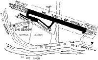
Runways
Runway Summary
| Runways: | 10/28 |
| Longest Runway: | 10/28 is 3354 ft (1022 m) long |
| Runways with an Instrument Approach: |
S72 Airport Runway Details
| Runway 10/28 | 3354 ft x 60 ft (1022 m x 18 m) | |
| Runway Length Source: | ADO as of 02/01/2012 | |
| Surface: | Asphalt - Excellent condition - No special surface treatment | |
| Runway Edge Lights: | Medium Intensity | |
Runway Weight Bearing Capacity (in thousands of pounds) |
||
| Single Wheel Landing Gear: | 12.5 | |
Runway 10 |
Runway 28 |
|
Elevation: |
2131.3 | 2126.3 |
Latitude: |
47-19-39.9600N | 47-19-25.8800N |
Longitude: |
116-34-58.0700W | 116-34-14.0100W |
|
Runway True Alignment: |
115 | 295 |
Glide Path Angle: |
0.0 degrees | 0.0 degrees |
Traffic Pattern: |
Right | Left |
Runway Markings Type: |
Basic | Basic |
Runway Markings Condition: |
Good | Good |
Object at End: |
ROAD | TREES |
Object Height: |
45 | 45 |
Distance from End: |
600 | 1700 |
Object Centerline Offset: |
165 ft. right of centerline | 0 ft. left and right of centerline |
REIL: |
No |
Services
Airframe Repair: |
None |
Powerplant Repair: |
None |
Bottled Oxygen: |
None |
Bulk Oxygen: |
None |
Fuel Available: |
100LL |
Landing Fees: |
No |
Parking: |
Tiedowns available |
Maps & Diagrams
S72 Sectional
Flight Planning
at skyvector.com
at skyvector.com