Location
Latitude: |
48-17-58.3000N (48.299528) |
Longitude: |
116-33-36.5000W (-116.560139) |
Elevation: |
2131.0 feet MSL (650 m MSL) |
Magnetic Variation: |
13.9 E (as of April 2024 from WMM2020 model) |
Time Zone: |
UTC -8.0 (Standard Time) UTC -7.0 (Daylight Savings Time) |
From City: |
02 N.M. N of Sandpoint, Idaho |
Found On: |
Great Falls Chart |
FAA Region: |
ANM |
Contacts
Manager: |
Publicly owned: |
| DAVE SCHUCK 1500 HWY 2 SUITE 308 SANDPOINT, ID 83864 208-265-2266 |
BONNER COUNTY 1500 HWY 2 SANDPOINT, ID 83864 208-265-1438 |
Operations
Airport Status: |
Operational |
Facility Use: |
Public |
Type: |
Airport |
Activation Date: |
04/1940 |
Control tower: |
No |
Attendance (Months/Days/Hours): |
Months/Days/Hours SUMMER/ALL/0700-1700 |
Boundary ARTCC: |
ZSE (Seattle) |
Responsible ARTCC: |
ZSE (Seattle) |
Lighting Schedule: |
SEE RMK |
Segmented Circle Indicator: |
Yes |
Traffic Pattern Altitude (MSL): |
3131 feet (954 m) |
NOTAMs Facility: |
SZT |
NOTAM-D Service: |
Yes |
International Airport of Entry: |
No |
Customs Landing Rights: |
No |
Military Landing Rights: |
Yes |
Civil/Military Joint Use: |
No |
Based Aircraft
| Single Engine: | 28 |
| Multi Engine: | 4 |
| Gliders: | 2 |
Annual Operations (as of 07/30/2022)
| Total Operations: | 30100 | |
| Air Taxi: | 600 | 2.0% |
| GA Local: | 10000 | 33.2% |
| GA Itinerant: | 19500 | 64.8% |
Communications
| CTAF: | 122.700 |
| Unicom: | 122.700 |
| AWOS-3: | 135.425 (208-263-3074) |
- APCH/DEP CTL SVC PRVDD BY SEATTLE ARTCC (ZSE) ON FREQS 123.95/290.55 (LAKESIDE RCAG.)
Fixed Based Operators (FBOs) & Fuel
(Click on a business for detail)
Please help us keep this information up to date. This is a FREE SERVICE just like everything else on Airport Guide! If you see that a business needs to be added, modified, or deleted please fill out our Update Form.
To add, modify, or delete a business click here.
Please help us keep this information up to date. This is a FREE SERVICE just like everything else on Airport Guide! If you see that a business needs to be added, modified, or deleted please fill out our Update Form.
Area Code: 208 |
| Business Name | Frequency | Phone | Fuel Grade |
|---|---|---|---|
| Sandpoint Aviation
Update FBO info |
Unicom 122.8 | 263-9102 | 100LL, Jet A |
Flight Service Stations
| Primary | Alternate | |
| FSS on Field: | N | |
| FSS Name (ID): | Boise(BOI) | |
| Frequency: | ||
| Toll Free Phone: | 1-800-WX-BRIEF |
Instrument Procedures / Charts
FAA Terminal Procedures valid from 0901Z 03/21/24 to 0901Z 04/18/24.
There are various types of charts available for an airport. They are listed in the Page Type column. Here is a legend for those types:
APD - Airport Diagram
DP - Departure Procedure Charts
HOT - Hot Spots
IAP - Instrument Approach Procedure Charts
MIN - Minimums
STAR - Standard Terminal Arrival Charts
| Page Type | Page Name | Volume | Action Since Last Cycle |
|---|---|---|---|
| IAP | LOC-A | NW-1 | Changed |
| IAP | RNAV (GPS) Y RWY 20 | NW-1 | |
| IAP | RNAV (GPS) Z RWY 20 | NW-1 | |
| IAP | RNAV (GPS)-B | NW-1 | |
| MIN | ALTERNATE MINIMUMS | NW-1 | |
| MIN | TAKEOFF MINIMUMS | NW-1 |
Terminal Procedures are only available for airports in several countries with more being added all the time. If you are looking for a specific country's charts, please send an email to support(at)airportguide.com stating the country name. This will be used to prioritize the implementation.
Navigation Aids (Navaids) near KSZT
| Dist (NM) | ID | Morse Code | Name | Type | Freq | True Hdg | Mag Hdg |
|---|---|---|---|---|---|---|---|
| 0.5 | SZT | . . . _ _ . . _ | Sandpoe | NDB | 264 | 192 | 178 |
| 33.2 | COE | _ . _ . _ _ _ . | Coeur D'alene | VOR-DME | 108.80 | 198 | 184 |
| 37.1 | LEN | . _ . . . _ . | Post Falls | NDB | 347 | 205 | 191 |
| 40.0 | DPY | _ . . . _ _ . _ . _ _ | Deer Park | NDB | 365 | 240 | 226 |
| 41.9 | ION | . . _ _ _ _ . | Ione | NDB | 379 | 306 | 292 |
| 42.4 | LYI | . _ . . _ . _ _ . . | Libby | NDB | 414 | 89 | 75 |
| 44.7 | U6 | Creston | NDB | 360 | 4 | 350 | |
| 48.1 | SFF | . . . . . _ . . . _ . | Spokane/Felts Field | VOT | 114.00 | 219 | 205 |
| 51.7 | CRK | _ . _ . . _ . _ . _ | Canyon | NDB | 388 | 224 | 210 |
| 52.6 | W6 | Creston North | NDB | 233 | 358 | 344 | |
| 56.6 | GEG | _ _ . . _ _ . | Spokane Intl | VOT | 109.60 | 223 | 209 |
| 60.6 | SKA | . . . _ . _ . _ | Fairchild | TACAN | 111.40 | 227 | 213 |
| 61.5 | GEG | _ _ . . _ _ . | Spokane | VORTAC | 115.50 | 224 | 210 |
| 62.5 | MLP | _ _ . _ . . . _ _ . | Mullan Pass | VOR-DME | 117.80 | 143 | 129 |
| 70.9 | EUR | . . . _ . _ . | Eureka | NDB | 392 | 55 | 41 |
| 71.4 | EF | Champion | NDB | 206 | 323 | 309 | |
| 71.9 | XCG | Castlegar | DME | 110.10 | 323 | 309 | |
| 74.8 | YK | Brilliant | NDB | 269 | 325 | 311 | |
| 77.6 | YXC | _ . _ _ _ . . _ _ . _ . | Cranbrook | VOR-DME | 112.10 | 13 | 359 |
| 79.7 | CG | Castlegar | NDB | 227 | 330 | 316 |
Nearby Airports with Fuel
Notices to Airmen (NOTAMS)
Remarks
| A110-1 | RWY 20: ADNL OBSTN +23 FT R AT 680 FT ON CNTRLN, 85+ FT TREES AT 1500 FT ON CNTRLN. |
| A110-2 | WILDLIFE INVOF ARPT. |
| A110-3 | FOR CD CTC SEATTLE ARTCC AT 253-351-3694. |
| A81-APT | ACTVT REIL RWY 02 & 20; MIRL 02/20 - CTAF. PAPI RWY 02 & 20 OPR CONSLY. |
| E111 | ESTABD PRIOR TO 15 MAY 59. |
Runways
Runway Summary
| Runways: | 02/20 |
| Longest Runway: | 02/20 is 5501 ft (1677 m) long |
| Runways with an Instrument Approach: | 02 |
KSZT Airport Runway Details
| Runway 02/20 | 5501 ft x 75 ft (1677 m x 23 m) | |
| Runway Length Source: | 3RD PARTY SURVEY as of 12/22/2005 | |
| Surface: | Asphalt - Good condition - No special surface treatment | |
| Runway Edge Lights: | Medium Intensity | |
Runway Weight Bearing Capacity (in thousands of pounds) |
||
| Single Wheel Landing Gear: | 40.0 | |
Runway 02 |
Runway 20 |
|
Elevation: |
2128.3 | 2128.9 |
Latitude: |
48-17-35.3711N | 48-18-21.3214N |
Longitude: |
116-33-58.1602W | 116-33-14.8514W |
|
Runway True Alignment: |
032 | 212 |
ILS Type: |
LOC/DME | |
Glide Path Angle: |
3.8 degrees | 3.8 degrees |
Traffic Pattern: |
Left | Left |
Runway Markings Type: |
Nonprecision Instrument | Nonprecision Instrument |
Runway Markings Condition: |
Good | Good |
Object at End: |
TREES | TREES |
Object Height: |
60 | 90 |
Distance from End: |
850 | 610 |
Object Centerline Offset: |
75 ft. right of centerline | 280 ft. right of centerline |
Visual Glide Slope Indicators: |
2-Light PAPI On Left Side Of Runway | 2-Light PAPI On Left Side Of Runway |
REIL: |
Yes | Yes |
Threshold Crossing Height: |
28 | 50 |
Services
Airframe Repair: |
Minor |
Powerplant Repair: |
Minor |
Bottled Oxygen: |
None |
Bulk Oxygen: |
None |
Fuel Available: |
100LL, Jet A |
Landing Fees: |
No |
Parking: |
Tiedowns available |
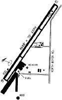
Maps & Diagrams
KSZT Sectional
Flight Planning
at skyvector.com
at skyvector.com