Location
Latitude: |
46-44-30.0890N (46.741691) |
Longitude: |
117-06-41.8290W (-117.111619) |
Elevation: |
2566.6 feet MSL (782 m MSL) |
Magnetic Variation: |
13.8 E (as of April 2024 from WMM2020 model) |
Time Zone: |
UTC -8.0 (Standard Time) UTC -7.0 (Daylight Savings Time) |
From City: |
03 N.M. NE of Pullman/Moscow,Id, Washington |
Found On: |
Seattle Chart |
FAA Region: |
ANM |
Contacts
Manager: |
Publicly owned: |
| ANTHONY BEAN 3200 AIRPORT COMPLEX N PULLMAN, WA 99163 509-338-3223 |
PULLMAN MOSCOW RGL ARPT BOARD 3200 AIRPORT COMPLEX N PULLMAN, WA 99163 509-338-3223 |
Operations
Airport Status: |
Operational |
Facility Use: |
Public |
Type: |
Airport |
Activation Date: |
02/1938 |
Control tower: |
No |
Attendance (Months/Days/Hours): |
Months/Days/Hours ALL/ALL/0800-1800 |
Boundary ARTCC: |
ZSE (Seattle) |
Responsible ARTCC: |
ZSE (Seattle) |
Lighting Schedule: |
SEE RMK |
Segmented Circle Indicator: |
Yes |
Traffic Pattern Altitude (MSL): |
3567 feet (1087 m) |
NOTAMs Facility: |
PUW |
NOTAM-D Service: |
Yes |
International Airport of Entry: |
No |
Customs Landing Rights: |
No |
Military Landing Rights: |
Yes |
Civil/Military Joint Use: |
No |
Aircraft Rescue and Firefighting: |
Class I ARFF Index: B Air Carrier Service: Scheduled Certification Date: 05/1973 |
Based Aircraft
| Single Engine: | 60 |
| Multi Engine: | 7 |
| Jet Engine: | 3 |
| Gliders: | 1 |
Annual Operations (as of 12/02/2021)
| Total Operations: | 29370 | |
| Air Taxi: | 4270 | 14.5% |
| GA Local: | 12000 | 40.9% |
| GA Itinerant: | 13000 | 44.3% |
| Military Aircraft: | 100 | 0.3% |
Communications
| CTAF: | 122.800 |
| Unicom: | 122.800 |
| ASOS: | 135.675 (509-334-3222) |
- APCH/DEP CTL SVC PRVDD BY SEATTLE ARTCC (ZSE) ON FREQS 123.95/290.55 (COTTONWOOD RCAG).
Fixed Based Operators (FBOs) & Fuel
(Click on a business for detail)
Please help us keep this information up to date. This is a FREE SERVICE just like everything else on Airport Guide! If you see that a business needs to be added, modified, or deleted please fill out our Update Form.
To add, modify, or delete a business click here.
Please help us keep this information up to date. This is a FREE SERVICE just like everything else on Airport Guide! If you see that a business needs to be added, modified, or deleted please fill out our Update Form.
Area Code: 509 |
| Business Name | Frequency | Phone | Fuel Grade |
|---|---|---|---|
| Inter-State Aviation
Update FBO info |
Unicom 122.8 | 332-6596 | 80, 100, Jet A, Mogas |
Flight Service Stations
| Primary | Alternate | |
| FSS on Field: | N | |
| FSS Name (ID): | Seattle(SEA) | |
| Frequency: | ||
| Toll Free Phone: | 1-800-WX-BRIEF |
Instrument Procedures / Charts
FAA Terminal Procedures valid from 0901Z 03/21/24 to 0901Z 04/18/24.
There are various types of charts available for an airport. They are listed in the Page Type column. Here is a legend for those types:
APD - Airport Diagram
DP - Departure Procedure Charts
HOT - Hot Spots
IAP - Instrument Approach Procedure Charts
MIN - Minimums
STAR - Standard Terminal Arrival Charts
| Page Type | Page Name | Volume | Action Since Last Cycle |
|---|---|---|---|
| APD | AIRPORT DIAGRAM | NW-1 | |
| IAP | ILS OR LOC RWY 05 | NW-1 | |
| IAP | RNAV (GPS) RWY 05 | NW-1 | |
| IAP | RNAV (GPS) Y RWY 23 | NW-1 | Changed |
| IAP | RNAV (RNP) Z RWY 23 | NW-1 | |
| IAP | VOR RWY 05 | NW-1 | |
| MIN | ALTERNATE MINIMUMS | NW-1 | |
| MIN | TAKEOFF MINIMUMS | NW-1 |
Terminal Procedures are only available for airports in several countries with more being added all the time. If you are looking for a specific country's charts, please send an email to support(at)airportguide.com stating the country name. This will be used to prioritize the implementation.
Navigation Aids (Navaids) near PUW
| Dist (NM) | ID | Morse Code | Name | Type | Freq | True Hdg | Mag Hdg |
|---|---|---|---|---|---|---|---|
| 6.1 | PUW | . _ _ . . . _ . _ _ | Pullman | VOR-DME | 117.15 | 228 | 214 |
| 23.8 | MQG | _ _ _ _ . _ _ _ . | Nez Perce | VOR-DME | 114.45 | 155 | 141 |
| 48.6 | IDQ | . . _ . . _ _ . _ | Cottonwood | DME | 115.65 | 146 | 132 |
| 53.7 | GEG | _ _ . . _ _ . | Spokane | VORTAC | 115.50 | 337 | 323 |
| 55.0 | GEG | _ _ . . _ _ . | Spokane Intl | VOT | 109.60 | 342 | 328 |
| 56.2 | AL | . _ . _ . . | Trina | NDB | 353 | 233 | 219 |
| 56.7 | SKA | . . . _ . _ . _ | Fairchild | TACAN | 111.40 | 336 | 322 |
| 57.0 | SFF | . . . . . _ . . . _ . | Spokane/Felts Field | VOT | 114.00 | 351 | 337 |
| 57.8 | CRK | _ . _ . . _ . _ . _ | Canyon | NDB | 388 | 346 | 332 |
| 60.4 | LEN | . _ . . . _ . | Post Falls | NDB | 347 | 5 | 351 |
| 62.7 | ALW | . _ . _ . . . _ _ | Walla Walla | VOR-DME | 116.40 | 231 | 217 |
| 63.0 | COE | _ . _ . _ _ _ . | Coeur D'alene | VOR-DME | 108.80 | 10 | 356 |
| 73.7 | MLP | _ _ . _ . . . _ _ . | Mullan Pass | VOR-DME | 117.80 | 53 | 39 |
| 74.7 | DPY | _ . . . _ _ . _ . _ _ | Deer Park | NDB | 365 | 350 | 336 |
| 87.5 | PSC | . _ _ . . . . _ . _ . | Pasco | VOR-DME | 113.75 | 251 | 237 |
| 91.1 | LGD | . _ . . _ _ . _ . . | La Grande | NDB | 296 | 203 | 189 |
| 91.4 | MW | _ _ . _ _ | Pelly | NDB | 408 | 284 | 270 |
| 92.0 | PD | . _ _ . _ . . | Foris | NDB | 230 | 227 | 213 |
| 94.6 | MWH | _ _ . _ _ . . . . | Moses Lake | VOR-DME | 115.00 | 288 | 274 |
| 95.6 | SZT | . . . _ _ . . _ | Sandpoe | NDB | 264 | 13 | 359 |
Nearby Airports with Fuel
Notices to Airmen (NOTAMS)
Remarks
| A110-1 | NO NON- PAVED ACFT OPS AUTH. |
| A110-2 | NUMEROUS OBJECTS PENETRATE IMAGINARY SFCS JUST NORTH AND SOUTH OF RWY. |
| A110-3 | FOR CD IF UNA TO CTC ON FSS FREQ, CTC SEATTLE ARTCC AT 253-351-3694. |
| A24 | LANDING FEE FOR ALL COMMERCIAL ACFT AND ALL ITINERANT ACFT OVER 7000 LBS. |
| A26 | CLSD TO UNSKED ACR OPNS WITH MORE THAN 30 PSGR SEATS EXCP PPR CALL AMGR 509-338-3223. |
| A81-APT | ACTVT MALSR RWY 05; REIL RWY 23; PAPI RWY 05 & 23; HIRL RWY 5/23 - CTAF |
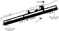
Runways
Runway Summary
| Runways: | 05/23 |
| Longest Runway: | 05/23 is 7100 ft (2164 m) long |
| Runways with an Instrument Approach: | 05 |
PUW Airport Runway Details
| Runway 05/23 | 7100 ft x 150 ft (2164 m x 46 m) | |
| Runway Length Source: | 3RD PARTY SURVEY as of 10/01/2019 | |
| Surface: | Asphalt - Good condition - Saw-cut or plastic grooved | |
| Runway Pavement Class: | 68 /F/C/X/T | |
| Runway Edge Lights: | High Intensity | |
Runway Weight Bearing Capacity (in thousands of pounds) |
||
| Single Wheel Landing Gear: | 120.0 | |
| Dual Wheel Landing Gear: | 239.0 | |
| Dual Tandem Wheel Landing Gear: | 385.0 | |
Runway 05 |
Runway 23 |
|
Elevation: |
2566.6 | 2552.3 |
Latitude: |
46-44-15.0395N | 46-44-45.1353N |
Longitude: |
117-07-27.8573W | 117-05-55.8031W |
|
Runway True Alignment: |
065 | 245 |
ILS Type: |
ILS/DME | |
Glide Path Angle: |
3.0 degrees | 3.4 degrees |
Traffic Pattern: |
Left | Left |
Runway Markings Type: |
Precision Instrument | Precision Instrument |
Runway Markings Condition: |
Good | Good |
Object at End: |
FENCE | GND |
Object Height: |
7 | 29 |
Distance from End: |
374 | 200 |
Object Centerline Offset: |
253 ft. left of centerline | 250 ft. left of centerline |
Visual Glide Slope Indicators: |
4-Light PAPI On Left Side Of Runway | 4-Light PAPI On Right Side Of Runway |
Runway Visual Range (RVR): |
Touchdown | Rollout |
Approach Light System: |
1,400 Foot Medium Intensity Approach Lighting System With Runway Alignment Indicator Lights | |
REIL: |
No | Yes |
Threshold Crossing Height: |
49 | 58 |
Declared Distances |
||
Take Off Run Avbl. (TORA): |
7100 | 7100 |
Take Off Distance Avbl. (TODA): |
7100 | 7100 |
Actual Stop Dist. Avbl. (ASDA): |
7100 | 7100 |
Landing Dist. Avbl. (LDA): |
7100 | 7100 |
Services
Airframe Repair: |
Minor |
Powerplant Repair: |
Minor |
Bottled Oxygen: |
None |
Bulk Oxygen: |
None |
Fuel Available: |
100LL |
Landing Fees: |
No |
Parking: |
Tiedowns available |
Maps & Diagrams
PUW Sectional
Flight Planning
at skyvector.com
at skyvector.com