Location
Latitude: |
47-58-01.3970N (47.967055) |
Longitude: |
117-25-42.9120W (-117.428587) |
Elevation: |
2210.7 feet MSL (674 m MSL) |
Magnetic Variation: |
14.1 E (as of April 2024 from WMM2020 model) |
Time Zone: |
UTC -8.0 (Standard Time) UTC -7.0 (Daylight Savings Time) |
From City: |
03 N.M. NE of Deer Park, Washington |
Found On: |
Seattle Chart |
FAA Region: |
ANM |
Contacts
Manager: |
Publicly owned: |
| DAROLD SCHULTZ PO BOX F DEER PARK, WA 99006 509-276-3379 |
CITY OF DEER PARK 316 E. CRAWFORD DEER PARK, WA 99006 509-276-8802 |
Operations
Airport Status: |
Operational |
Facility Use: |
Public |
Type: |
Airport |
Activation Date: |
12/1943 |
Control tower: |
No |
Attendance (Months/Days/Hours): |
Months/Days/Hours APR-OCT/ALL/0800-1700 |
Boundary ARTCC: |
ZSE (Seattle) |
Responsible ARTCC: |
ZSE (Seattle) |
Lighting Schedule: |
SEE RMK |
Segmented Circle Indicator: |
Yes |
Traffic Pattern Altitude (MSL): |
3211 feet (979 m) |
NOTAMs Facility: |
DEW |
NOTAM-D Service: |
Yes |
International Airport of Entry: |
No |
Customs Landing Rights: |
No |
Military Landing Rights: |
Yes |
Civil/Military Joint Use: |
No |
Based Aircraft
| Single Engine: | 118 |
| Multi Engine: | 2 |
| Jet Engine: | 2 |
| GA Helicopters: | 1 |
| Gliders: | 3 |
Annual Operations (as of 12/31/2021)
| Total Operations: | 36540 | |
| GA Local: | 19065 | 52.2% |
| GA Itinerant: | 17475 | 47.8% |
Communications
| CTAF: | 123.000 |
| Unicom: | 123.000 |
| Approach: | SPOKANE 123.75 123.75 |
| Departure: | SPOKANE 123.75 123.75 |
| ASOS: | 135.175 (509-276-2303) |
Fixed Based Operators (FBOs) & Fuel
(Click on a business for detail)
Please help us keep this information up to date. This is a FREE SERVICE just like everything else on Airport Guide! If you see that a business needs to be added, modified, or deleted please fill out our Update Form.
To add, modify, or delete a business click here.
Please help us keep this information up to date. This is a FREE SERVICE just like everything else on Airport Guide! If you see that a business needs to be added, modified, or deleted please fill out our Update Form.
Area Code: 509 |
| Business Name | Frequency | Phone | Fuel Grade |
|---|---|---|---|
| Arrow H Aviation
Update FBO info |
Unicom 123.0 | 276-8149 | |
| Discount Aircraft Salvage
Update FBO info |
276-2849 | ||
| Partners Aviation
Update FBO info |
Unicom 122.8 | 276-8663 | 100LL |
| Sher Flight
Update FBO info |
Unicom 123.0 | 276-2892 |
Flight Service Stations
| Primary | Alternate | |
| FSS on Field: | N | |
| FSS Name (ID): | Seattle(SEA) | |
| Frequency: | ||
| Toll Free Phone: | 1-800-WX-BRIEF |
Instrument Procedures / Charts
FAA Terminal Procedures valid from 0901Z 03/21/24 to 0901Z 04/18/24.
There are various types of charts available for an airport. They are listed in the Page Type column. Here is a legend for those types:
APD - Airport Diagram
DP - Departure Procedure Charts
HOT - Hot Spots
IAP - Instrument Approach Procedure Charts
MIN - Minimums
STAR - Standard Terminal Arrival Charts
| Page Type | Page Name | Volume | Action Since Last Cycle |
|---|---|---|---|
| IAP | RNAV (GPS) RWY 16 | NW-1 | Changed |
| IAP | RNAV (GPS) RWY 34 | NW-1 | |
| MIN | ALTERNATE MINIMUMS | NW-1 | |
| MIN | DIVERSE VECTOR AREA | NW-1 | |
| MIN | TAKEOFF MINIMUMS | NW-1 |
Terminal Procedures are only available for airports in several countries with more being added all the time. If you are looking for a specific country's charts, please send an email to support(at)airportguide.com stating the country name. This will be used to prioritize the implementation.
Navigation Aids (Navaids) near KDEW
| Dist (NM) | ID | Morse Code | Name | Type | Freq | True Hdg | Mag Hdg |
|---|---|---|---|---|---|---|---|
| 0.1 | DPY | _ . . . _ _ . _ . _ _ | Deer Park | NDB | 365 | 67 | 53 |
| 17.4 | CRK | _ . _ . . _ . _ . _ | Canyon | NDB | 388 | 182 | 168 |
| 17.7 | SFF | . . . . . _ . . . _ . | Spokane/Felts Field | VOT | 114.00 | 165 | 151 |
| 21.6 | GEG | _ _ . . _ _ . | Spokane Intl | VOT | 109.60 | 190 | 176 |
| 23.1 | LEN | . _ . . . _ . | Post Falls | NDB | 347 | 125 | 111 |
| 23.4 | SKA | . . . _ . _ . _ | Fairchild | TACAN | 111.40 | 203 | 189 |
| 25.4 | GEG | _ _ . . _ _ . | Spokane | VORTAC | 115.50 | 198 | 184 |
| 27.1 | COE | _ . _ . _ _ _ . | Coeur D'alene | VOR-DME | 108.80 | 115 | 101 |
| 39.7 | SZT | . . . _ _ . . _ | Sandpoe | NDB | 264 | 60 | 46 |
| 44.6 | ION | . . _ _ _ _ . | Ione | NDB | 379 | 0 | 346 |
| 74.4 | 2J | Grand Forks | NDB-DME | 250 | 328 | 314 | |
| 74.8 | U6 | Creston | NDB | 360 | 29 | 15 | |
| 77.7 | XCG | Castlegar | DME | 110.10 | 353 | 339 | |
| 77.8 | EF | Champion | NDB | 206 | 354 | 340 | |
| 78.0 | PUW | . _ _ . . . _ . _ _ | Pullman | VOR-DME | 117.15 | 173 | 159 |
| 78.2 | MLP | _ _ . _ . . . _ _ . | Mullan Pass | VOR-DME | 117.80 | 112 | 98 |
| 79.6 | W6 | Creston North | NDB | 233 | 23 | 9 | |
| 80.0 | LYI | . _ . . _ . _ _ . . | Libby | NDB | 414 | 74 | 60 |
| 81.9 | YK | Brilliant | NDB | 269 | 354 | 340 | |
| 88.0 | EPH | . . _ _ . . . . . | Ephrata | VORTAC | 112.60 | 247 | 233 |
Nearby Airports with Fuel
Notices to Airmen (NOTAMS)
Remarks
| A110-10 | MONITOR GLIDER TRAFFIC ON 123.3 ABOVE 5,000 FT MSL. |
| A110-11 | FOR CD CTC SPOKANE APCH AT 509-742-2522 |
| A110-2 | MODEL AIRPLANE ACTIVITY ON ARPT. |
| A110-3 | COYOTES ON AND INVOF RUNWAYS. |
| A110-5 | RY 05/23 HEAVY GLIDER ACTIVITY ON WEEKENDS. |
| A110-6 | FARMING OPN ACTIVE ON LAND ADJACENT TO RYS. |
| A110-7 | NOISE ABATEMENT PROCEDURES IN EFFECT CTC AMGR 509-276-3379. |
| A110-8 | RY 16 PREFERRED CALM WIND RY. |
| A110-9 | 175 FT TOWER 2000 FT W OF RY 16/34. |
| A14 | EMAIL: DEERPARKAIRPORT@GMAIL.COM |
| A16 | CELL 509-999-5835. |
| A70-FUEL-10 | 0LL 100LL AND JET A AVBL 24 HRS CREDIT CARD SELF SVC FACILITY. CALL AHEAD FOR FULL SVC, JET A SVC 509-276-3379. |
| A75 | PILOTS BRING OWN ROPES. |
| A81-APT | ACTVT REIL RWY 16 AND RWY 34; MIRL RWY 16/34 - CTAF. PAPI RWY 16 & 34 OPR CONSLY. |
| E111 | ESTABD PRIOR TO 1959. |
| E147 | GLIDER PATTERN TPA 1000 FT. |
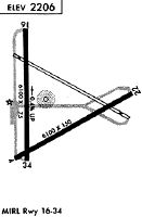
Runways
Runway Summary
| Runways: | 05/23 16/34 |
| Longest Runway: | 16/34 is 6101 ft (1860 m) long |
| Runways with an Instrument Approach: |
KDEW Airport Runway Details
| Runway 05/23 | 3200 ft x 60 ft (975 m x 18 m) | |
| Runway Length Source: | 3RD PARTY SURVEY as of 02/26/2021 | |
| Surface: | Asphalt - Good condition - No special surface treatment | |
| Runway Pavement Class: | 17 /F/C/W/T | |
Runway Weight Bearing Capacity (in thousands of pounds) |
||
| Single Wheel Landing Gear: | 12.5 | |
Runway 05 |
Runway 23 |
|
Elevation: |
2188.1 | 2183.1 |
Latitude: |
47-57-43.4996N | 47-57-58.6848N |
Longitude: |
117-25-45.8310W | 117-25-04.6078W |
|
Runway True Alignment: |
061 | 241 |
Glide Path Angle: |
0.0 degrees | 0.0 degrees |
Runway Markings Type: |
Basic | Basic |
Runway Markings Condition: |
Fair | Fair |
| Runway 16/34 | 6101 ft x 75 ft (1860 m x 23 m) | |
| Runway Length Source: | 3RD PARTY SURVEY as of 02/26/2021 | |
| Surface: | Asphalt - Good condition - No special surface treatment | |
| Runway Edge Lights: | Medium Intensity | |
Runway Weight Bearing Capacity (in thousands of pounds) |
||
| Single Wheel Landing Gear: | 30.0 | |
| Dual Wheel Landing Gear: | 50.0 | |
Runway 16 |
Runway 34 |
|
Elevation: |
2210.7 | 2185.6 |
Latitude: |
47-58-36.9021N | 47-57-36.7005N |
Longitude: |
117-25-52.3428W | 117-25-52.0430W |
|
Runway True Alignment: |
180 | 360 |
Glide Path Angle: |
3.5 degrees | 3.0 degrees |
Traffic Pattern: |
Left | Left |
Runway Markings Type: |
Nonprecision Instrument | Nonprecision Instrument |
Runway Markings Condition: |
Fair | Fair |
Object at End: |
TREES | |
Object Height: |
60 | |
Distance from End: |
2900 | |
Visual Glide Slope Indicators: |
4-Light PAPI On Left Side Of Runway | 4-Light PAPI On Left Side Of Runway |
REIL: |
Yes | Yes |
Threshold Crossing Height: |
38 | 40 |
Services
Airframe Repair: |
Minor |
Powerplant Repair: |
Minor |
Bottled Oxygen: |
None |
Bulk Oxygen: |
None |
Fuel Available: |
100LL |
Landing Fees: |
No |
Parking: |
Tiedowns available |
Maps & Diagrams
KDEW Sectional
Flight Planning
at skyvector.com
at skyvector.com