Location
Latitude: |
44-28-19.0380N (44.471955) |
Longitude: |
073-09-11.7940W (-73.153276) |
Elevation: |
334.6 feet MSL (102 m MSL) |
Magnetic Variation: |
13.8 W (as of April 2024 from WMM2020 model) |
Time Zone: |
UTC -5.0 (Standard Time) UTC -4.0 (Daylight Savings Time) |
From City: |
03 N.M. E of Burlington, Vermont |
Found On: |
Montreal Chart |
FAA Region: |
ANE |
Contacts
Manager: |
Publicly owned: |
| NICOLAS LONGO 1200 ARPT DR NO 1 SOUTH BURLINGTON, VT 05403 802-863-2874 |
CITY OF BURLINGTON CITY HALL BURLINGTON, VT 05401 802-865-7272 |
Operations
Airport Status: |
Operational |
Facility Use: |
Public |
Type: |
Airport |
Activation Date: |
09/1937 |
Control tower: |
Yes |
Attendance (Months/Days/Hours): |
Months/Days/Hours ALL/ALL/ALL |
Boundary ARTCC: |
ZBW (Boston) |
Responsible ARTCC: |
ZBW (Boston) |
Lighting Schedule: |
SEE RMK |
Segmented Circle Indicator: |
No |
Traffic Pattern Altitude (MSL): |
1335 feet (407 m) |
NOTAMs Facility: |
BTV |
NOTAM-D Service: |
Yes |
International Airport of Entry: |
Yes |
Customs Landing Rights: |
No |
Military Landing Rights: |
Yes |
Aircraft Rescue and Firefighting: |
Class I ARFF Index: B Air Carrier Service: Scheduled Certification Date: 05/1973 |
Based Aircraft
| Single Engine: | 71 |
| Multi Engine: | 10 |
| Jet Engine: | 11 |
| GA Helicopters: | 5 |
| Military Aircraft: | 32 |
| Ultralights: | 1 |
Annual Operations (as of 07/01/2023)
| Total Operations: | 112523 | |
| Commercial: | 17416 | 15.5% |
| Air Taxi: | 7428 | 6.6% |
| GA Local: | 42517 | 37.8% |
| GA Itinerant: | 40386 | 35.9% |
| Military Aircraft: | 4776 | 4.2% |
Communications
| CTAF: | 118.300 |
| Unicom: | 122.950 |
| Tower: | BURLINGTON 118.3 257.8 290.9 388.2 Hrs: 0530-0000 |
| Clearance Del.: | 119.15 |
| Ground: | 126.3 348.6 |
| Approach: | BURLINGTON 121.1 278.8 Hrs: 0530-0000 BOSTON ARTCC Hrs: 0000-0530 |
| Departure: | BURLINGTON 121.1 278.8 Hrs: 0530-0000 BOSTON ARTCC Hrs: 0000-0530 |
| ATIS: | 123.8 269.9 Hrs: 24 |
| ASOS: | 123.8 (802-657-4490) |
| ARNG OPS: | 242.4 |
| EMERG: | 243.0 |
| ARNG OPS: | 41.2 |
| CLASS C: | 121.1 |
| EMERG: | 121.5 |
| ARNG OPS: | 123.3 |
| CLASS C: | 278.8 |
| ANG OPS: | 293.7 |
| ARNG OPS: | 134.1 |
- APCH/DEP SVC PRVDD BY BOSTON ARTCC ON FREQS 120.35/342.25 (ST. ALBANS RCAG) WHEN BURLINGTON APCH CTL CLSD.
Fixed Based Operators (FBOs) & Fuel
(Click on a business for detail)
Please help us keep this information up to date. This is a FREE SERVICE just like everything else on Airport Guide! If you see that a business needs to be added, modified, or deleted please fill out our Update Form.
To add, modify, or delete a business click here.
Please help us keep this information up to date. This is a FREE SERVICE just like everything else on Airport Guide! If you see that a business needs to be added, modified, or deleted please fill out our Update Form.
Area Code: 802 |
| Business Name | Frequency | Phone | Fuel Grade |
|---|---|---|---|
| Heritage Aviation
Website Update FBO info |
Unicom 123.5 | 802-863-3626 | 100LL, Jet A |

|
Phillips | 100LL - 4.85 USD per gallon on 4/1/09 |
Trucks |
|
|
Phillips | Jet A - 3.60 USD per gallon on 4/1/09 |
Trucks |
| Innotech Aviation
Update FBO info |
Unicom 122.95 | 658-2200 | 100LL, Jet A |
| MasterTech, Inc.
Update FBO info |
863-8119 | ||
| Pratt & Whitney Service Center
Update FBO info |
658-2208 | ||
| Warplanes, Inc.
Update FBO info |
862-2080 |
Flight Service Stations
| Primary | Alternate | |
| FSS on Field: | N | |
| FSS Name (ID): | Burlington(BTV) | |
| Frequency: | ||
| Toll Free Phone: | 1-800-WX-BRIEF |
Instrument Procedures / Charts
FAA Terminal Procedures valid from 0901Z 03/21/24 to 0901Z 04/18/24.
There are various types of charts available for an airport. They are listed in the Page Type column. Here is a legend for those types:
APD - Airport Diagram
DP - Departure Procedure Charts
HOT - Hot Spots
IAP - Instrument Approach Procedure Charts
MIN - Minimums
STAR - Standard Terminal Arrival Charts
| Page Type | Page Name | Volume | Action Since Last Cycle |
|---|---|---|---|
| APD | AIRPORT DIAGRAM | NE-1 | |
| DP | BURLINGTON ONE | NE-1 | |
| HOT | HOT SPOT | NE-1 | |
| IAP | HI-ILS OR LOC RWY 15 | NE-1 | |
| IAP | HI-LOC RWY 33 | NE-1 | |
| IAP | HI-TACAN RWY 15 | NE-1 | |
| IAP | HI-TACAN RWY 33 | NE-1 | |
| IAP | ILS OR LOC RWY 15 | NE-1 | |
| IAP | ILS OR LOC/DME RWY 33 | NE-1 | |
| IAP | RNAV (GPS) RWY 01 | NE-1 | |
| IAP | RNAV (GPS) RWY 15 | NE-1 | |
| IAP | RNAV (GPS) Y RWY 33 | NE-1 | |
| IAP | RNAV (GPS) Z RWY 33 | NE-1 | |
| IAP | VOR RWY 01 | NE-1 | |
| LAH | LAHSO | NE-1 | |
| MIN | ALTERNATE MINIMUMS | NE-1 | |
| MIN | TAKEOFF MINIMUMS | NE-1 |
Terminal Procedures are only available for airports in several countries with more being added all the time. If you are looking for a specific country's charts, please send an email to support(at)airportguide.com stating the country name. This will be used to prioritize the implementation.
Navigation Aids (Navaids) near BTV
| Dist (NM) | ID | Morse Code | Name | Type | Freq | True Hdg | Mag Hdg |
|---|---|---|---|---|---|---|---|
| 0.1 | BTV | _ . . . _ . . . _ | Burlington | VOT | 109.00 | 233 | 247 |
| 0.3 | BJA | _ . . . . _ _ _ . _ | Burlington | TACAN | 112.40 | 333 | 347 |
| 4.7 | BTV | _ . . . _ . . . _ | Burlington | VOR-DME | 117.50 | 195 | 209 |
| 5.5 | BT | _ . . . _ | Herro | NDB | 382 | 311 | 325 |
| 20.3 | PLB | . _ _ . . _ . . _ . . . | Plattsburgh | VORTAC | 116.90 | 309 | 323 |
| 38.1 | MPV | _ _ . _ _ . . . . _ | Montpelier | VOR-DME | 116.90 | 127 | 141 |
| 41.6 | SLK | . . . . _ . . _ . _ | Briel | NDB | 395 | 270 | 284 |
| 41.6 | SL | . . . . _ . . | Briel | NDB | 395 | 270 | 284 |
| 45.3 | SLK | . . . . _ . . _ . _ | Saranac Lake | DME | 109.2 | 263 | 277 |
| 46.7 | DYO | _ . . _ . _ _ _ _ _ | Smuto | NDB | 221 | 169 | 183 |
| 47.6 | YJN | St-Jean | VORTAC | 115.80 | 351 | 365 | |
| 47.6 | YJN | _ . _ _ . _ _ _ _ . | St Jean | VOR-DME | 115.80 | 351 | 365 |
| 48.1 | LLX | . _ . . . _ . . _ . . _ | Lyndonville | NDB | 353 | 87 | 101 |
| 51.0 | R | . _ . | Chitt | FAN MARKER | 170 | 184 | |
| 52.7 | I6R | Bromont | DME | 110.70 | 19 | 33 | |
| 57.4 | RUT | . _ . . . _ _ | Rutland | DME | 111 | 171 | 185 |
| 62.2 | IVV | . . . . . _ . . . _ | White River | NDB | 379 | 151 | 165 |
| 62.4 | LEB | . _ . . . _ . . . | Lebanon | DME | 113.7 | 139 | 153 |
| 62.5 | LAH | . _ . . . _ . . . . | Hanover | NDB | 276 | 137 | 151 |
| 63.2 | GMA | _ _ . _ _ . _ | Mahn | NDB | 386 | 95 | 109 |
Nearby Airports with Fuel
Notices to Airmen (NOTAMS)
Remarks
| A110-1 | CTN: GENERATING PLANT 2 NM FROM AER 15 PRODUCES STEAM WHICH MAY OBSC VSBTY ON FNA. |
| A110-10 | TWY L CLSD TO ACFT OVR 60000 LBS. |
| A110-12 | ANG: NON-STD TWY LGTS ON TWY E. |
| A110-14 | TWYS D, E, F, N CLSD TO CIVILIAN OPS. |
| A110-15 | SERVICE-A-GEAR: TYPE H/BAK-12A(B) AER 33 LCTD 1000 FT FM DTHR. TYPE H/BAK 12A(B) CABLE RAISED BY TWR ON PILOT REQ ONLY. RWY 15 & RWY 33 A-G HOUSINGS ARE NON-FRANGIBLE (26 IN ABV GRD LEVEL) LCTD 250 FT FM RWY CNTLN. |
| A110-2 | ACR RAMP NOT AVBL FOR PVT & CHTR ACFT. |
| A110-20 | ANG: OPR 1030-2100Z++ WKDAYS, EXC HOL, CLSD SAT-MON. PPR FOR FUEL/PRKG, CTC ANG OPS DSN 220-5213/5920/5267 C802-660-5213. ALL TSNT ACFT ENR ETHAN ALLEN TRNG SITE AND R-6501A MUST STOP AT AASF FOR RQRD SAFETY BRIEF. |
| A110-21 | TWY M AVBL FOR SEASONAL USE, CLSD DRG WINTER MONTHS. |
| A110-23 | FIGHTER ACFT: NO LOW APCHS. ALL OTHER MIL ACFT LTD TO TWO PRACTICE APCHS. DO NOT FLY OVER HOSPITAL APRXLY 1.5 NM WEST OF RWY 15 APCH END. |
| A110-25 | TWY A BTN TWY G & TWY C CLSD TO ACFT WINGSPAN MORE THAN 118 FT EXC 1 HR PPR 802-316-6014 DLY. |
| A110-26 | FBO CLSD 0200-0900 DLY, EXC 1 HR PPR 802-863-3626. |
| A110-29 | COLD TEMPERATURE AIRPORT. ALTITUDE CORRECTION REQUIRED AT OR BELOW -10C. |
| A110-3 | BIRDS & DEER ON & INVOF ARPT. |
| A110-30 | ARFF AVBL 24 HRS. |
| A110-33 | CAUTION: PHASE II WILDLIFE ACTVY DURG MIGRATION, MAR-MAY & AUG15-NOV15. |
| A110-34 | FOR CD IF TWR CLSD & UNA TO CTC FSS FREQ, CTC BOSTON ARTCC AT 603-879-6859. |
| A110-35 | BETA HELIPAD PVT USE ONLY. |
| A110-36 | TWY G BTWN J & VALLEY RAMP CLSD TO ACFT WINGSPAN GTR THAN 156 FT. |
| A110-37 | TWY K CLSD TO ACFT WINGSPAN MORE THAN 49 FT AND ACFT MORE THAN 12500 LB. |
| A110-5 | TWYS D, E, F, N, ANG & RNG RAMPS HAVE UNCONTROLLED VEHICLES & ACFT. |
| A110-9 | FIGHTER ACFT RSTRD TO TKOF WINDOW OF 0830-2230 MON-SAT; 1200-2230 SUN. |
| A24 | FEE FOR ITNRNT ACFT GTR THAN 6000 LBS. |
| A35-01/19 | SOUTH OF RWY 15/33 INTXN TO TWY C, SW 100 DTW 355; SOUTH OF TWY C INTXN TO SOUTH END OF RWY, SW 30 DW 60. |
| A57-01 | 20:1 TO DTHR. |
| A57-33 | 30:1 TO DTHR. |
| A81-APT | DUSK-DAWN. ACTVT MALSR RWY 15; MALSF RWY 33; PAPI RWY 01 & 15; MIRL RWY 01/19; HIRL RWY 15/33; ALL TWYS - CTAF. PAPI RWY 19 & 33 OPR CONSLY. |
| E111 | EXISTED PRIOR TO 1959. |
| E60-15 | TYPE H/BAK-12A (B) 1499 FT. |
| E60-33 | TYPE H/BAK-12A (B) 1500 FT. |
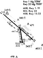
Runways
Runway Summary
| Runways: | 01/19 15/33 |
| Longest Runway: | 15/33 is 8319 ft (2536 m) long |
| Runways with an Instrument Approach: | 15, 33 |
BTV Airport Runway Details
| Runway 01/19 | 4112 ft x 75 ft (1253 m x 23 m) | |
| Runway Length Source: | 3RD PARTY SURVEY as of 06/18/2018 | |
| Surface: | Asphalt - Good condition - No special surface treatment | |
| Runway Pavement Class: | 23 /F/A/X/T | |
| Runway Edge Lights: | Medium Intensity | |
Runway Weight Bearing Capacity (in thousands of pounds) |
||
| Single Wheel Landing Gear: | 30.0 | |
| Dual Wheel Landing Gear: | 40.0 | |
| Dual Tandem Wheel Landing Gear: | 60.0 | |
Runway 01 |
Runway 19 |
|
Elevation: |
333.7 | 326.8 |
Latitude: |
44-27-49.7731N | 44-28-29.9208N |
Longitude: |
073-09-03.6111W | 073-09-12.0677W |
|
Runway True Alignment: |
351 | 171 |
Glide Path Angle: |
4.0 degrees | 3.5 degrees |
Runway Markings Type: |
Nonprecision Instrument | Basic |
Runway Markings Condition: |
Good | Good |
Object at End: |
TREE | |
Object Height: |
63 | |
Distance from End: |
1290 | |
Object Centerline Offset: |
25 ft. left of centerline | |
Visual Glide Slope Indicators: |
4-Light PAPI On Left Side Of Runway | 4-Light PAPI On Right Side Of Runway |
Threshold Crossing Height: |
27 | 47 |
Threshold Elevation: |
333.0 | 329.4 |
Displaced Threshold: |
225 | 500 |
Threshold Latitude: |
44-27-51.9666N | 44-28-25.0387N |
Threshold Longitude: |
073-09-04.0734W | 073-09-11.0392W |
Declared Distances |
||
Take Off Run Avbl. (TORA): |
3611 | 4111 |
Take Off Distance Avbl. (TODA): |
3611 | 4111 |
Actual Stop Dist. Avbl. (ASDA): |
3611 | 4111 |
Landing Dist. Avbl. (LDA): |
3386 | 3386 |
| Runway 15/33 | 8319 ft x 150 ft (2536 m x 46 m) | |
| Runway Length Source: | 3RD PARTY SURVEY as of 06/18/2018 | |
| Surface: | Asphalt - Good condition - Saw-cut or plastic grooved | |
| Runway Pavement Class: | 39 /F/A/X/T | |
| Runway Edge Lights: | High Intensity | |
Runway Weight Bearing Capacity (in thousands of pounds) |
||
| Single Wheel Landing Gear: | 100.0 | |
| Dual Wheel Landing Gear: | 175.0 | |
| Dual Tandem Wheel Landing Gear: | 355.0 | |
Runway 15 |
Runway 33 |
|
Elevation: |
305.5 | 334.6 |
Latitude: |
44-28-50.4283N | 44-27-56.7291N |
Longitude: |
073-09-57.1639W | 073-08-30.3457W |
|
Runway True Alignment: |
131 | 311 |
ILS Type: |
ILS/DME | ILS/DME |
Glide Path Angle: |
3.0 degrees | 3.2 degrees |
Traffic Pattern: |
Left | |
Runway Markings Type: |
Precision Instrument | Precision Instrument |
Runway Markings Condition: |
Good | Good |
Arresting Device: |
MA-1A | BAK-12 |
Object at End: |
TREES | TREES |
Object Height: |
51 | 75 |
Distance from End: |
1930 | 1975 |
Object Centerline Offset: |
25 ft. left of centerline | |
Visual Glide Slope Indicators: |
4-Light PAPI On Right Side Of Runway | 4-Light PAPI On Right Side Of Runway |
Runway Visual Range (RVR): |
Touchdown, Rollout | Touchdown, Rollout |
Approach Light System: |
1,400 Foot Medium Intensity Approach Lighting System With Runway Alignment Indicator Lights | 1,400 Foot Medium Intensity Approach Lighting System With Sequenced Flashers |
REIL: |
No | |
Threshold Crossing Height: |
51 | 53 |
Threshold Elevation: |
334.2 | |
Displaced Threshold: |
500 | |
Threshold Latitude: |
44-27-59.9566N | |
Threshold Longitude: |
073-08-35.5625W | |
Declared Distances |
||
Take Off Run Avbl. (TORA): |
7820 | 8320 |
Take Off Distance Avbl. (TODA): |
7820 | 8320 |
Actual Stop Dist. Avbl. (ASDA): |
7820 | 8320 |
Landing Dist. Avbl. (LDA): |
7820 | 7820 |
Services
Airframe Repair: |
Minor |
Powerplant Repair: |
Minor |
Bottled Oxygen: |
None |
Bulk Oxygen: |
None |
Fuel Available: |
100LL, Jet A |
Landing Fees: |
No |
Parking: |
Tiedowns available |
Maps & Diagrams
BTV Sectional
Flight Planning
at skyvector.com
at skyvector.com