Location
Latitude: |
40-37-02.8180N (40.617449) |
Longitude: |
074-14-40.5390W (-74.244594) |
Elevation: |
22.0 feet MSL (7 m MSL) |
Magnetic Variation: |
12.5 W (as of April 2024 from WMM2020 model) |
Time Zone: |
UTC -5.0 (Standard Time) UTC -4.0 (Daylight Savings Time) |
From City: |
01 N.M. SE of Linden, New Jersey |
Found On: |
New York Chart |
FAA Region: |
AEA |
Contacts
Manager: |
Publicly owned: |
| PAUL DUDLEY 1101 WEST EDGAR RD LINDEN, NJ 07036 908-862-5557 |
CITY OF LINDEN 1101 WEST EDGAR RD LINDEN, NJ 07036 908-862-5557 |
Operations
Airport Status: |
Operational |
Facility Use: |
Public |
Type: |
Airport |
Activation Date: |
10/1942 |
Control tower: |
No |
Attendance (Months/Days/Hours): |
Months/Days/Hours MAY-SEP/ALL/0700-2030 |
Boundary ARTCC: |
ZNY (New York) |
Responsible ARTCC: |
ZNY (New York) |
Lighting Schedule: |
SEE RMK |
Segmented Circle Indicator: |
Yes |
Traffic Pattern Altitude (MSL): |
1022 feet (312 m) |
NOTAMs Facility: |
MIV |
NOTAM-D Service: |
Yes |
International Airport of Entry: |
No |
Customs Landing Rights: |
No |
Military Landing Rights: |
Yes |
Civil/Military Joint Use: |
No |
Based Aircraft
| Single Engine: | 18 |
| Multi Engine: | 1 |
| GA Helicopters: | 1 |
Annual Operations (as of 06/30/2023)
| Total Operations: | 62050 | |
| GA Local: | 38750 | 62.4% |
| GA Itinerant: | 23150 | 37.3% |
| Military Aircraft: | 150 | 0.2% |
Communications
| CTAF: | 123.000 |
| Unicom: | 123.000 |
| Approach: | NEW YORK |
| Departure: | NEW YORK |
| AWOS-3: | 124.025 (908-862-7383) |
- CLEARANCE DELIVERY PRVDD ON FREQ 127.25 BY NEWARK ATCT, OR CTC NEW YORK APCH AT 800-645-3206.
Fixed Based Operators (FBOs) & Fuel
(Click on a business for detail)
Please help us keep this information up to date. This is a FREE SERVICE just like everything else on Airport Guide! If you see that a business needs to be added, modified, or deleted please fill out our Update Form.
To add, modify, or delete a business click here.
Please help us keep this information up to date. This is a FREE SERVICE just like everything else on Airport Guide! If you see that a business needs to be added, modified, or deleted please fill out our Update Form.
Area Code: 908 |
| Business Name | Frequency | Phone | Fuel Grade |
|---|---|---|---|
| Linden Air Services
Update FBO info |
Unicom 123.0 | 862-5557 | 100LL, Jet A |
| Sky Sign, Inc.
Update FBO info |
800-759-7446 |
Flight Service Stations
| Primary | Alternate | |
| FSS on Field: | N | |
| FSS Name (ID): | Millville(MIV) | |
| Frequency: | ||
| Toll Free Phone: | 1-800-WX-BRIEF |
Instrument Procedures / Charts
FAA Terminal Procedures valid from 0901Z 03/21/24 to 0901Z 04/18/24.
There are various types of charts available for an airport. They are listed in the Page Type column. Here is a legend for those types:
APD - Airport Diagram
DP - Departure Procedure Charts
HOT - Hot Spots
IAP - Instrument Approach Procedure Charts
MIN - Minimums
STAR - Standard Terminal Arrival Charts
| Page Type | Page Name | Volume | Action Since Last Cycle |
|---|---|---|---|
| IAP | GPS-A | NE-2 | |
| MIN | TAKEOFF MINIMUMS | NE-2 | |
| STAR | JAIKE FOUR (RNAV) | NE-2 | |
| STAR | JAIKE FOUR (RNAV)[DELIMITER] CONT.1 | NE-2 | |
| STAR | MAZIE THREE (RNAV) | NE-2 | |
| STAR | WILKES-BARRE FOUR | NE-2 |
Terminal Procedures are only available for airports in several countries with more being added all the time. If you are looking for a specific country's charts, please send an email to support(at)airportguide.com stating the country name. This will be used to prioritize the implementation.
Navigation Aids (Navaids) near LDJ
| Dist (NM) | ID | Morse Code | Name | Type | Freq | True Hdg | Mag Hdg |
|---|---|---|---|---|---|---|---|
| 4.6 | EWR | . . _ _ . _ . | Newark | DME | 113.75 | 41 | 54 |
| 5.8 | EWR | . . _ _ . _ . | Maryann | FAN MARKER | 26 | 39 | |
| 11.2 | CAT | _ . _ . . _ _ | Chatham | NDB | 254 | 311 | 323 |
| 12.3 | TE | _ . | Torby | NDB | 214 | 24 | 37 |
| 16.0 | CRI | _ . _ . . _ . . . | Canarsie | VOR-DME | 112.30 | 90 | 103 |
| 16.2 | TEB | _ . _ . . . | Teterboro | VOR-DME | 108.40 | 30 | 43 |
| 16.7 | OGY | _ _ _ _ _ . _ . _ _ | Bridge | NDB | 414 | 100 | 113 |
| 18.8 | COL | _ . _ . _ _ _ . _ . . | Colts Neck | VOR-DME | 115.40 | 168 | 180 |
| 19.8 | LGA | . _ . . _ _ . . _ | La Guardia | VOR-DME | 113.10 | 59 | 72 |
| 21.6 | JFK | . _ _ _ . . _ . _ . _ | Kennedy | VOR-DME | 115.90 | 87 | 100 |
| 22.7 | SBJ | . . . _ . . . . _ _ _ | Solberg | VOR-DME | 112.90 | 264 | 276 |
| 27.4 | RBV | . _ . _ . . . . . . _ | Robbinsville | VORTAC | 113.80 | 204 | 216 |
| 28.4 | BWZ | _ . . . . _ _ _ _ . . | Broadway | VOR-DME | 114.20 | 292 | 304 |
| 30.1 | SAX | . . . . _ _ . . _ | Sparta | VORTAC | 115.70 | 333 | 345 |
| 34.6 | NEL | _ . . . _ . . | Lakehurst | NDB | 396 | 186 | 198 |
| 35.2 | NEL | _ . . . _ . . | Lakehurst | TACAN | 111.80 | 188 | 200 |
| 36.0 | FR | . . _ . . _ . | Frikk | NDB | 407 | 74 | 87 |
| 36.3 | STW | . . . _ . _ _ | Stillwater | VOR-DME | 109.60 | 308 | 320 |
| 37.3 | ARD | . _ . _ . _ . . | Yardley | VOR-DME | 108.20 | 234 | 246 |
| 39.3 | BBN | _ . . . _ . . . _ . | Babylon | NDB | 275 | 84 | 97 |
Nearby Airports with Fuel
Notices to Airmen (NOTAMS)
Remarks
| A110-1 | TPA 800 FT MSL; RY 9 ENTER TFC PAT UPWIND - ENTRIES OTR RYS STD. |
| A110-11 | DEER & BIRDS ON & INVOF APRT. |
| A110-2 | DEPG RY 27 DEP STRAIGHT OUT TO 800 FT. |
| A110-3 | NOISE ABATEMENT PROCEDURES IN EFFECT. |
| A110-6 | TOUCH & GO LANDINGS FOR BASE ASSIGNED ACFT; ALL OTHERS CTC AMGR (908) 862-8800 FOR PPR. |
| A110-8 | RY 09/27 RWY SHOULDER MARKINGS NSTD. |
| A110-9 | MAIN NORTH TWY CLSD INDEFLY. |
| A43-09 | VASI UNUSBL BYD 6 DEGS RIGHT AND LEFT OF CNTRLN. |
| A43-27 | VASI UNUSBL BYD 2 DEGS RIGHT OF CNTRLN. |
| A57-09 | APCH RATIO 25:1 TO DSPLCD THLD BASED ON 32 FT POLE 812 FT FM DSPLCD THLD. |
| A57-27 | APCH RATIO 23:1 TO DTHR BASED ON 47 FT ANT 1097 FT FM DTHR. |
| A81-APT | ACTVT MIRL RY 09/27; VASI RYS 09 & 27; AND REILS RYS 09 & 27- CTAF. |
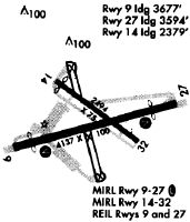
Runways
Runway Summary
| Runways: | 09/27 |
| Longest Runway: | 09/27 is 4140 ft (1262 m) long |
| Runways with an Instrument Approach: |
LDJ Airport Runway Details
| Runway 09/27 | 4140 ft x 100 ft (1262 m x 30 m) | |
| Runway Length Source: | 3RD PARTY SURVEY as of 05/12/2017 | |
| Surface: | Asphalt - Good condition - No special surface treatment | |
| Runway Edge Lights: | Medium Intensity | |
Runway Weight Bearing Capacity (in thousands of pounds) |
||
| Single Wheel Landing Gear: | 31.5 | |
| Dual Wheel Landing Gear: | 42.0 | |
Runway 09 |
Runway 27 |
|
Elevation: |
21.9 | 17.9 |
Latitude: |
40-36-57.7590N | 40-37-07.8762N |
Longitude: |
074-15-06.5443W | 074-14-14.5330W |
|
Runway True Alignment: |
076 | 256 |
Glide Path Angle: |
3.8 degrees | 3.5 degrees |
Traffic Pattern: |
Left | Left |
Runway Markings Type: |
Nonprecision Instrument | Basic |
Runway Markings Condition: |
Fair | Fair |
Object at End: |
POLE | ANT |
Object Height: |
32 | 47 |
Distance from End: |
352 | 554 |
Object Centerline Offset: |
30 ft. right of centerline | 100 ft. right of centerline |
Visual Glide Slope Indicators: |
2-Box VASI On Right Side Of Runway | 2-Box VASI On Left Side Of Runway |
REIL: |
Yes | Yes |
Threshold Crossing Height: |
60 | 40 |
Threshold Elevation: |
21.8 | 19.3 |
Displaced Threshold: |
462 | 541 |
Threshold Latitude: |
40-36-58.8876N | 40-37-06.5552N |
Threshold Longitude: |
074-15-00.7449W | 074-14-21.3246W |
Services
Airframe Repair: |
Major |
Powerplant Repair: |
Major |
Bottled Oxygen: |
None |
Bulk Oxygen: |
None |
Fuel Available: |
100LL |
Landing Fees: |
No |
Parking: |
Tiedowns available |
Maps & Diagrams
LDJ Sectional
Flight Planning
at skyvector.com
at skyvector.com