Location
Latitude: |
32-55-15.6000N (32.921) |
Longitude: |
080-38-26.2000W (-80.640611) |
Elevation: |
100.9 feet MSL (31 m MSL) |
Magnetic Variation: |
7.8 W (as of April 2024 from WMM2020 model) |
Time Zone: |
UTC -5.0 (Standard Time) UTC -4.0 (Daylight Savings Time) |
From City: |
02 N.M. NE of Walterboro, South Carolina |
Found On: |
Charlotte Chart |
FAA Region: |
ASO |
Contacts
Manager: |
Publicly owned: |
| BERT DUFFIE 537 AVIATION WAY WALTERBORO, SC 29488 843-955-0290 |
CITY OF WALTERBORO AND COLLETON CO. 537 AVIATION WAY WALTERBORO, SC 29488 843-549-2549 |
Operations
Airport Status: |
Operational |
Facility Use: |
Public |
Type: |
Airport |
Activation Date: |
10/1937 |
Control tower: |
No |
Attendance (Months/Days/Hours): |
Months/Days/Hours ALL/ALL/0830-1800 |
Boundary ARTCC: |
ZJX (Jacksonville) |
Responsible ARTCC: |
ZJX (Jacksonville) |
Lighting Schedule: |
SEE RMK |
Segmented Circle Indicator: |
No |
Traffic Pattern Altitude (MSL): |
1101 feet (336 m) |
NOTAMs Facility: |
AND |
NOTAM-D Service: |
Yes |
International Airport of Entry: |
No |
Customs Landing Rights: |
No |
Military Landing Rights: |
Yes |
Civil/Military Joint Use: |
No |
Based Aircraft
| Single Engine: | 30 |
| Multi Engine: | 8 |
| Jet Engine: | 1 |
Annual Operations (as of 05/19/2023)
| Total Operations: | 28648 | |
| Air Taxi: | 4040 | 14.1% |
| GA Local: | 8601 | 30.0% |
| GA Itinerant: | 15387 | 53.7% |
| Military Aircraft: | 620 | 2.2% |
Communications
| CTAF: | 122.800 |
| Unicom: | 122.800 |
| Approach: | CHARLESTON 120.7 120.7 |
| Departure: | CHARLESTON 120.7 120.7 |
| AWOS-3PT: | 118.725 (843-538-3575) |
Fixed Based Operators (FBOs) & Fuel
(Click on a business for detail)
Please help us keep this information up to date. This is a FREE SERVICE just like everything else on Airport Guide! If you see that a business needs to be added, modified, or deleted please fill out our Update Form.
To add, modify, or delete a business click here.
Please help us keep this information up to date. This is a FREE SERVICE just like everything else on Airport Guide! If you see that a business needs to be added, modified, or deleted please fill out our Update Form.
Area Code: 843 |
| Business Name | Frequency | Phone | Fuel Grade |
|---|---|---|---|
| Walterboro Municipal Airport
Update FBO info |
Unicom 122.8 | 549-2549 | 100LL, Jet A |
Flight Service Stations
| Primary | Alternate | |
| FSS on Field: | N | |
| FSS Name (ID): | Anderson(AND) | |
| Frequency: | ||
| Toll Free Phone: | 1-800-WX-BRIEF |
Instrument Procedures / Charts
FAA Terminal Procedures valid from 0901Z 03/21/24 to 0901Z 04/18/24.
There are various types of charts available for an airport. They are listed in the Page Type column. Here is a legend for those types:
APD - Airport Diagram
DP - Departure Procedure Charts
HOT - Hot Spots
IAP - Instrument Approach Procedure Charts
MIN - Minimums
STAR - Standard Terminal Arrival Charts
| Page Type | Page Name | Volume | Action Since Last Cycle |
|---|---|---|---|
| IAP | ILS Y OR LOC Y RWY 23 | SE-2 | |
| IAP | ILS Z OR LOC Z RWY 23 | SE-2 | |
| IAP | RNAV (GPS) RWY 05 | SE-2 | |
| IAP | RNAV (GPS) RWY 17 | SE-2 | |
| IAP | RNAV (GPS) RWY 23 | SE-2 | |
| IAP | RNAV (GPS) RWY 35 | SE-2 | |
| MIN | ALTERNATE MINIMUMS | SE-2 | |
| MIN | TAKEOFF MINIMUMS | SE-2 |
Terminal Procedures are only available for airports in several countries with more being added all the time. If you are looking for a specific country's charts, please send an email to support(at)airportguide.com stating the country name. This will be used to prioritize the implementation.
Navigation Aids (Navaids) near RBW
| Dist (NM) | ID | Morse Code | Name | Type | Freq | True Hdg | Mag Hdg |
|---|---|---|---|---|---|---|---|
| 0.3 | RBW | . _ . _ . . . . _ _ | Walterboro | NDB | 221 | 4 | 12 |
| 20.1 | DYB | _ . . _ . _ _ _ . . . | Dorchester County | NDB | 365 | 65 | 73 |
| 26.8 | NBC | _ . _ . . . _ . _ . | Beaufort | TACAN | 110.50 | 188 | 196 |
| 27.5 | CH | _ . _ . . . . . | Ashly | NDB | 329 | 82 | 90 |
| 30.2 | CHS | _ . _ . . . . . . . . | Charleston | VOT | 111.00 | 91 | 99 |
| 30.4 | CHS | _ . _ . . . . . . . . | Charleston | VORTAC | 113.50 | 92 | 100 |
| 33.3 | ALD | . _ . _ . . _ . . | Allendale | VOR | 116.70 | 279 | 287 |
| 33.9 | EDS | . _ . . . . . | Edisto | VOR-DME | 111.40 | 341 | 349 |
| 34.6 | VAN | . . . _ . _ _ . | Vance | VORTAC | 110.40 | 16 | 24 |
| 45.6 | MNI | _ _ _ . . . | Manning | NDB | 381 | 28 | 36 |
| 50.8 | JYL | . _ _ _ _ . _ _ . _ . . | Sylvania | NDB | 245 | 251 | 259 |
| 54.4 | SAV | . . . . _ . . . _ | Savannah | VORTAC | 115.95 | 211 | 219 |
| 55.5 | SAV | . . . . _ . . . _ | Savannah Travis Fld | VOT | 111.00 | 210 | 218 |
| 57.7 | SV | . . . . . . _ | Wassa | NDB | 335 | 197 | 205 |
| 59.0 | SA | . . . . _ | Mavis | NDB | 368 | 216 | 224 |
| 59.9 | CAE | _ . _ . . _ . | Columbia | VORTAC | 114.70 | 339 | 347 |
| 59.9 | BZ | _ . . . _ _ . . | Bullo | NDB | 407 | 239 | 246 |
| 60.1 | SVN | . . . . . . _ _ . | Hunter | VOR-DME | 111.60 | 205 | 213 |
| 60.7 | MMT | _ _ _ _ _ | Mc Entire | VORTAC | 113.20 | 352 | 360 |
| 61.9 | CKI | _ . _ . _ . _ . . | Kingstree | NDB | 404 | 39 | 47 |
Nearby Airports with Fuel
Notices to Airmen (NOTAMS)
Remarks
| A110-3 | FOR CD CTC CHARLESTON APCH AT 843 414-2832. |
| A110-4 | DEER ON AND INVOF ARPT WITH INCR ACT DRG NGT AND AT DUSK AND DAWN. |
| A30-09/27 | RWY 09/27 CLSD PERMLY. |
| A70-FUEL-A | FOR AFT HRS SVC CALL 843-549-2549. |
| A70-FUEL-10 | 0LL 100LL SELF-SVC FUEL AVBL 24 HRS. |
| A81-APT | ODALS RWY 23; MIRLS RWY 05/23; OPR CONSLY FM DUSK-2200. 2200 TO DAWN - CTAF. |
| A83 | (WIND INDCR) SUPPLRY LGTD WINDCONES RWY 23 AND MIDFIELD. |
| E111 | ARPT EXISTED PRIOR TO 1958. |
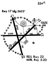
Runways
Runway Summary
| Runways: | 05/23 09/27 17/35 |
| Longest Runway: | 05/23 is 6002 ft (1829 m) long |
| Runways with an Instrument Approach: | 23 |
RBW Airport Runway Details
| Runway 05/23 | 6002 ft x 100 ft (1829 m x 30 m) | |
| Runway Length Source: | 3RD PARTY SURVEY as of 06/29/2009 | |
| Surface: | Asphalt/Concrete - Good condition - No special surface treatment | |
| Runway Pavement Class: | 26 /F/B/X/T | |
| Runway Edge Lights: | Medium Intensity | |
Runway Weight Bearing Capacity (in thousands of pounds) |
||
| Single Wheel Landing Gear: | 70.0 | |
| Dual Wheel Landing Gear: | 101.0 | |
Runway 05 |
Runway 23 |
|
Elevation: |
89.4 | 100.9 |
Latitude: |
32-54-56.6003N | 32-55-39.2751N |
Longitude: |
080-38-43.2448W | 080-37-54.2790W |
|
Runway True Alignment: |
044 | 224 |
ILS Type: |
ILS/DME | |
Glide Path Angle: |
3.5 degrees | 3.0 degrees |
Traffic Pattern: |
Left | Left |
Runway Markings Type: |
Nonprecision Instrument | Precision Instrument |
Runway Markings Condition: |
Good | Good |
Object at End: |
TREES | TREES |
Object Height: |
82 | 83 |
Distance from End: |
1999 | 2527 |
Object Centerline Offset: |
265 ft. right of centerline | 823 ft. left of centerline |
Visual Glide Slope Indicators: |
2-Light PAPI On Left Side Of Runway | 2-Light PAPI On Left Side Of Runway |
Approach Light System: |
Omnidirectional Approach Lighting System | |
REIL: |
No | Yes |
Touchdown Lights: |
No | No |
Centerline Lights: |
No | No |
Threshold Crossing Height: |
49 | 46 |
| Runway 09/27 | 5408 ft x 100 ft (1648 m x 30 m) | |
| Runway Length Source: | 3RD PARTY SURVEY as of 06/29/2009 | |
| Surface: | Asphalt/Concrete - Good condition - No special surface treatment | |
Runway Weight Bearing Capacity (in thousands of pounds) |
||
| Single Wheel Landing Gear: | 17.0 | |
| Dual Wheel Landing Gear: | 40.0 | |
Runway 09 |
Runway 27 |
|
Elevation: |
80.9 | 92.2 |
Latitude: |
32-55-14.7309N | 32-55-16.0601N |
Longitude: |
080-38-57.9597W | 080-37-54.5344W |
|
Runway True Alignment: |
089 | 269 |
Glide Path Angle: |
0.0 degrees | 0.0 degrees |
Traffic Pattern: |
Left | Left |
Runway Markings Type: |
Basic | Basic |
Runway Markings Condition: |
Poor | Poor |
Object at End: |
TREES | |
Object Height: |
52 | 67 |
Distance from End: |
637 | 2105 |
Object Centerline Offset: |
265 ft. right of centerline | 823 ft. left of centerline |
REIL: |
No | No |
Touchdown Lights: |
No | No |
Centerline Lights: |
No | No |
| Runway 17/35 | 5705 ft x 100 ft (1739 m x 30 m) | |
| Runway Length Source: | 3RD PARTY SURVEY as of 06/29/2009 | |
| Surface: | Asphalt/Concrete - Good condition - No special surface treatment | |
| Runway Pavement Class: | 10 /F/B/X/T | |
Runway Weight Bearing Capacity (in thousands of pounds) |
||
| Single Wheel Landing Gear: | 33.5 | |
| Dual Wheel Landing Gear: | 50.5 | |
Runway 17 |
Runway 35 |
|
Elevation: |
82.3 | 91.6 |
Latitude: |
32-55-40.7760N | 32-54-46.1012N |
Longitude: |
080-38-42.1819W | 080-38-25.5501W |
|
Runway True Alignment: |
166 | 346 |
Glide Path Angle: |
0.0 degrees | 0.0 degrees |
Traffic Pattern: |
Left | Left |
Runway Markings Type: |
Nonprecision Instrument | Nonprecision Instrument |
Runway Markings Condition: |
Good | Good |
Object at End: |
TREE | TREE |
Object Height: |
17 | 57 |
Distance from End: |
233 | 2370 |
Object Centerline Offset: |
265 ft. right of centerline | 823 ft. left of centerline |
REIL: |
No | No |
Touchdown Lights: |
No | No |
Centerline Lights: |
No | No |
Services
Airframe Repair: |
None |
Powerplant Repair: |
None |
Bottled Oxygen: |
None |
Bulk Oxygen: |
None |
Fuel Available: |
100LL |
Landing Fees: |
No |
Parking: |
Tiedowns available |
Maps & Diagrams
RBW Sectional
Flight Planning
at skyvector.com
at skyvector.com