Location
Latitude: |
33-27-59.7000N (33.466583) |
Longitude: |
082-02-21.8000W (-82.039389) |
Elevation: |
422.3 feet MSL (129 m MSL) |
Magnetic Variation: |
7 W (as of April 2024 from WMM2020 model) |
Time Zone: |
UTC -5.0 (Standard Time) UTC -4.0 (Daylight Savings Time) |
From City: |
01 N.M. W of Augusta, Georgia |
Found On: |
Atlanta Chart |
FAA Region: |
ASO |
Contacts
Manager: |
Publicly owned: |
| STEVE GAY, PRES AUGUSTA AVIATION (FBO), 1775 HIGHLAND AVE AUGUSTA, GA 30904 706-733-8970 |
AUGUSTA-RICHMOND CO 535 TELFAIR STREET AUGUSTA, GA 30901 (706) 821-2300 |
Operations
Airport Status: |
Operational |
Facility Use: |
Public |
Type: |
Airport |
Activation Date: |
04/1940 |
Control tower: |
No |
Attendance (Months/Days/Hours): |
Months/Days/Hours ALL/ALL/0700-DUSK |
Boundary ARTCC: |
ZTL (Atlanta) |
Responsible ARTCC: |
ZTL (Atlanta) |
Lighting Schedule: |
SEE RMK |
Segmented Circle Indicator: |
No |
Traffic Pattern Altitude (MSL): |
1422 feet (433 m) |
NOTAMs Facility: |
DNL |
NOTAM-D Service: |
Yes |
International Airport of Entry: |
No |
Customs Landing Rights: |
No |
Military Landing Rights: |
Yes |
Civil/Military Joint Use: |
No |
Based Aircraft
| Single Engine: | 42 |
| Multi Engine: | 8 |
| Jet Engine: | 1 |
Annual Operations (as of 12/31/2021)
| Total Operations: | 30000 | |
| GA Local: | 18000 | 60.0% |
| GA Itinerant: | 12000 | 40.0% |
Communications
| CTAF: | 123.050 |
| Unicom: | 123.050 |
| Approach: | AUGUSTA 126.8 126.8 ATLANTA ARTCC |
| Departure: | AUGUSTA 126.8 126.8 ATLANTA ARTCC |
| ASOS: | 135.275 (706-481-8629) |
- APCH/DEP SVC PRVDD BY ATLANTA ARTCC ON FREQS 128.1/322.325 (AUGUSTA RCAG) WHEN AUGUSTA APCH CTL CLSD.
- TO OBTAIN CLNCS & CNL FLIGHT PLANS FROM GND CONTACT APCH CTL.
Fixed Based Operators (FBOs) & Fuel
(Click on a business for detail)
Please help us keep this information up to date. This is a FREE SERVICE just like everything else on Airport Guide! If you see that a business needs to be added, modified, or deleted please fill out our Update Form.
To add, modify, or delete a business click here.
Please help us keep this information up to date. This is a FREE SERVICE just like everything else on Airport Guide! If you see that a business needs to be added, modified, or deleted please fill out our Update Form.
Area Code: 706 |
| Business Name | Frequency | Phone | Fuel Grade |
|---|---|---|---|
| Augusta Aviation, Inc.
Update FBO info |
Unicom 122.8 | 733-8970 | 100LL, Jet A |
Flight Service Stations
| Primary | Alternate | |
| FSS on Field: | N | |
| FSS Name (ID): | Macon(MCN) | |
| Frequency: | ||
| Toll Free Phone: | 1-800-WX-BRIEF |
Instrument Procedures / Charts
FAA Terminal Procedures valid from 0901Z 03/21/24 to 0901Z 04/18/24.
There are various types of charts available for an airport. They are listed in the Page Type column. Here is a legend for those types:
APD - Airport Diagram
DP - Departure Procedure Charts
HOT - Hot Spots
IAP - Instrument Approach Procedure Charts
MIN - Minimums
STAR - Standard Terminal Arrival Charts
| Page Type | Page Name | Volume | Action Since Last Cycle |
|---|---|---|---|
| DP | AZALA FOUR (RNAV) | SE-4 | |
| DP | CHATT SIX (RNAV) | SE-4 | |
| DP | MISTY SIX (RNAV) | SE-4 | |
| DP | NDINA FIVE (RNAV) | SE-4 | |
| DP | SAMMI FOUR (RNAV) | SE-4 | |
| IAP | NDB RWY 11 | SE-4 | |
| IAP | RNAV (GPS) RWY 05 | SE-4 | |
| IAP | RNAV (GPS) Y RWY 11 | SE-4 | |
| IAP | VOR/DME-B | SE-4 | |
| MIN | ALTERNATE MINIMUMS | SE-4 | |
| MIN | TAKEOFF MINIMUMS | SE-4 |
Terminal Procedures are only available for airports in several countries with more being added all the time. If you are looking for a specific country's charts, please send an email to support(at)airportguide.com stating the country name. This will be used to prioritize the implementation.
Navigation Aids (Navaids) near DNL
| Dist (NM) | ID | Morse Code | Name | Type | Freq | True Hdg | Mag Hdg |
|---|---|---|---|---|---|---|---|
| 2.1 | EMR | . _ _ . _ . | Emory | NDB | 385 | 96 | 103 |
| 11.7 | AG | . _ _ _ . | Bushe | NDB | 233 | 156 | 163 |
| 15.7 | IRQ | . . . _ . _ _ . _ | Colliers | VORTAC | 113.90 | 337 | 344 |
| 21.3 | AIK | . _ . . _ . _ | Aiken | NDB | 347 | 58 | 65 |
| 29.0 | AA | . _ . _ | Cedar | NDB | 341 | 278 | 285 |
| 34.5 | LNH | . _ . . _ . . . . . | Millen | NDB | 205 | 173 | 180 |
| 42.9 | IIY | . . . . _ . _ _ | Washington/Wilkes County | NDB | 435 | 295 | 302 |
| 46.3 | ALD | . _ . _ . . _ . . | Allendale | VOR | 116.70 | 125 | 132 |
| 47.3 | GIW | _ _ . . . . _ _ | Coronaca | NDB | 239 | 357 | 364 |
| 47.4 | GRD | _ _ . . _ . _ . . | Greenwood | TACAN | 115.50 | 353 | 360 |
| 49.7 | CA | _ . _ . . _ | Murry | NDB | 362 | 52 | 59 |
| 50.3 | VV | . . . _ . . . _ | Junne | NDB | 353 | 282 | 289 |
| 52.3 | EEX | . . _ . . _ | Emanuel County | NDB | 309 | 203 | 210 |
| 52.6 | HIT | . . . . . . _ | Kaolin | NDB | 360 | 239 | 246 |
| 53.9 | JYL | . _ _ _ _ . _ _ . _ . . | Sylvania | NDB | 245 | 155 | 162 |
| 54.5 | EOE | . _ _ _ . | Enoree | NDB | 278 | 21 | 28 |
| 54.5 | CAE | _ . _ . . _ . | Columbia | VORTAC | 114.70 | 64 | 71 |
| 59.1 | EDS | . _ . . . . . | Edisto | VOR-DME | 111.40 | 90 | 97 |
| 59.3 | UMB | . . _ _ _ _ . . . | Culvr | NDB | 380 | 251 | 258 |
| 65.7 | BJT | _ . . . . _ _ _ _ | Bulldog | NDB | 221 | 296 | 303 |
Nearby Airports with Fuel
Notices to Airmen (NOTAMS)
Remarks
| A110-1 | PILOTS SHOULD BE ALERT FOR TURBO-JET TRAFFIC TRANSITING THE TRAFFIC AREA ENROUTE TO BUSH FIELD 6 MILES SOUTH. |
| A43-11 | RWY 11 PAPI UNSBL BYD 3 DEG LEFT OF RWY CNTLN, PAPI IS BAFFLED |
| A57-05 | APCH RATIO 50:1 TO DSPLCD THLD |
| A57-11 | APCH RATIO 0:1 TO DSPLCD THLD; 20 FT ROAD/FENCE AT DSPLCD THLD & 245 FT LEFT. |
| A57-23 | APCH RATIO 16:1 TO DSPLCD THLD; 34FT LIGHT POLE, 577FT FROM THLD, 213FT RIGHT. |
| A57-29 | APCH RATIO 13:1 TO DSPLCD THLD; +55FT TREES 715FT FROM THLD, 139FT LEFT. |
| A58-11 | 6 FT FENCE 190 FT FM THRLD 94 FT RIGHT. |
| A58-23 | 6 FT FENCE 190 FT FM THR 125 FT R. |
| A81-APT | ACTVT REIL RWY 11; PAPI RWYS 05, 23, & 11; MIRL RWYS 05/23 & 11/29 - CTAF. |
| E111 | EXISTED PRIOR TO 1959. |
Runways
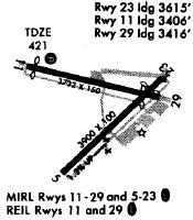
Runway Summary
| Runways: | 05/23 11/29 |
| Longest Runway: | 05/23 is 4002 ft (1220 m) long |
| Runways with an Instrument Approach: |
DNL Airport Runway Details
| Runway 05/23 | 4002 ft x 100 ft (1220 m x 30 m) | |
| Runway Length Source: | FAA as of 03/19/2013 | |
| Surface: | Asphalt - Good condition - Saw-cut or plastic grooved | |
| Runway Edge Lights: | Medium Intensity | |
Runway Weight Bearing Capacity (in thousands of pounds) |
||
| Single Wheel Landing Gear: | 30.0 | |
Runway 05 |
Runway 23 |
|
Elevation: |
373.9 | 422.3 |
Latitude: |
33-27-39.4600N | 33-28-07.0800N |
Longitude: |
082-02-36.9700W | 082-02-03.1100W |
|
Runway True Alignment: |
046 | 226 |
Glide Path Angle: |
3.0 degrees | 3.3 degrees |
Traffic Pattern: |
Left | Left |
Runway Markings Type: |
Nonprecision Instrument | Nonprecision Instrument |
Runway Markings Condition: |
Good | Good |
Object at End: |
TREE | ROAD |
Object Height: |
10 | 15 |
Distance from End: |
280 | 201 |
Object Centerline Offset: |
243 ft. right of centerline | 80 ft. right of centerline |
Visual Glide Slope Indicators: |
2-Light PAPI On Left Side Of Runway | 2-Light PAPI On Left Side Of Runway |
Threshold Crossing Height: |
30 | 26 |
Threshold Elevation: |
378.0 | 420.8 |
Displaced Threshold: |
202 | 298 |
Threshold Latitude: |
33-27-40.8600N | 33-28-05.0300N |
Threshold Longitude: |
082-02-35.2600W | 082-02-05.6300W |
| Runway 11/29 | 3733 ft x 100 ft (1138 m x 30 m) | |
| Runway Length Source: | 3RD PARTY SURVEY as of 12/16/2011 | |
| Surface: | Asphalt - Good condition - No special surface treatment | |
| Runway Edge Lights: | Medium Intensity | |
Runway Weight Bearing Capacity (in thousands of pounds) |
||
| Single Wheel Landing Gear: | 30.0 | |
Runway 11 |
Runway 29 |
|
Elevation: |
421.4 | 418.7 |
Latitude: |
33-28-10.9971N | 33-28-02.2384N |
Longitude: |
082-02-45.0453W | 082-02-02.2426W |
|
Runway True Alignment: |
104 | 284 |
Glide Path Angle: |
3.5 degrees | 0.0 degrees |
Traffic Pattern: |
Left | Left |
Runway Markings Type: |
Nonprecision Instrument | Nonprecision Instrument |
Runway Markings Condition: |
Good | Good |
Object at End: |
ROAD | ROAD |
Object Height: |
25 | 15 |
Object Marked/Lighted?: |
Lighted | |
Distance from End: |
201 | 201 |
Object Centerline Offset: |
243 ft. right of centerline | 80 ft. right of centerline |
Visual Glide Slope Indicators: |
4-Light PAPI On Left Side Of Runway | |
REIL: |
Yes | No |
Threshold Crossing Height: |
54 | |
Threshold Elevation: |
421.5 | 419.3 |
Displaced Threshold: |
326 | 314 |
Threshold Latitude: |
33-28-10.2318N | 33-28-02.9744N |
Threshold Longitude: |
082-02-41.3107W | 082-02-05.8478W |
Declared Distances |
||
Take Off Run Avbl. (TORA): |
3733 | 3733 |
Take Off Distance Avbl. (TODA): |
3733 | 3733 |
Actual Stop Dist. Avbl. (ASDA): |
3733 | 3733 |
Landing Dist. Avbl. (LDA): |
3407 | 3419 |
Services
Airframe Repair: |
Major |
Powerplant Repair: |
Major |
Bottled Oxygen: |
Low Pressure |
Fuel Available: |
100LL, Jet A |
Landing Fees: |
Yes |
Parking: |
Hangars and tiedowns available |
Maps & Diagrams
DNL Sectional
Flight Planning
at skyvector.com
at skyvector.com