Location
Latitude: |
42-06-04.0000N (42.101111) |
Longitude: |
072-02-19.8000W (-72.038833) |
Elevation: |
698.8 feet MSL (213 m MSL) |
Magnetic Variation: |
13.7 W (as of April 2024 from WMM2020 model) |
Time Zone: |
UTC -5.0 (Standard Time) UTC -4.0 (Daylight Savings Time) |
From City: |
02 N.M. N of Southbridge, Massachusetts |
Found On: |
New York Chart |
FAA Region: |
ANE |
Contacts
Manager: |
Publicly owned: |
| RONALD PLOUFFE 220 AIRPORT ACCESS RD SOUTHBRIDGE, MA 01550 508-764-2155 |
TOWN OF SOUTHBRIDGE 41 ELM STREET SOUTHBRIDGE, MA 01550 508-764-5405 |
Operations
Airport Status: |
Operational |
Facility Use: |
Public |
Type: |
Airport |
Activation Date: |
10/1946 |
Control tower: |
No |
Attendance (Months/Days/Hours): |
Months/Days/Hours ALL/ALL/0800-DUSK |
Boundary ARTCC: |
ZBW (Boston) |
Responsible ARTCC: |
ZBW (Boston) |
Lighting Schedule: |
SEE RMK |
Segmented Circle Indicator: |
Yes |
Traffic Pattern Altitude (MSL): |
1699 feet (518 m) |
NOTAMs Facility: |
BDR |
NOTAM-D Service: |
Yes |
International Airport of Entry: |
No |
Customs Landing Rights: |
No |
Military Landing Rights: |
Yes |
Civil/Military Joint Use: |
No |
Based Aircraft
| Single Engine: | 26 |
| GA Helicopters: | 1 |
Annual Operations (as of 12/31/2023)
| Total Operations: | 26550 | |
| Air Taxi: | 500 | 1.9% |
| GA Local: | 11000 | 41.4% |
| GA Itinerant: | 15000 | 56.5% |
| Military Aircraft: | 50 | 0.2% |
Communications
| CTAF: | 122.800 |
| Unicom: | 122.800 |
| Approach: | BRADLEY 119.0 119.0 |
| Departure: | BRADLEY 119.0 119.0 |
- CLNC DEL THRU BRIDGEPORT RADIO (BDR) 1-866-293-5149.
Fixed Based Operators (FBOs) & Fuel
(Click on a business for detail)
Please help us keep this information up to date. This is a FREE SERVICE just like everything else on Airport Guide! If you see that a business needs to be added, modified, or deleted please fill out our Update Form.
To add, modify, or delete a business click here.
Please help us keep this information up to date. This is a FREE SERVICE just like everything else on Airport Guide! If you see that a business needs to be added, modified, or deleted please fill out our Update Form.
Area Code: 508 |
| Business Name | Frequency | Phone | Fuel Grade |
|---|---|---|---|
| Jim's Flying Service
Update FBO info |
765-0226 | 100LL |
Flight Service Stations
| Primary | Alternate | |
| FSS on Field: | N | |
| FSS Name (ID): | Bridgeport(BDR) | |
| Frequency: | ||
| Toll Free Phone: | 1-800-WX-BRIEF |
Instrument Procedures / Charts
FAA Terminal Procedures valid from 0901Z 03/21/24 to 0901Z 04/18/24.
There are various types of charts available for an airport. They are listed in the Page Type column. Here is a legend for those types:
APD - Airport Diagram
DP - Departure Procedure Charts
HOT - Hot Spots
IAP - Instrument Approach Procedure Charts
MIN - Minimums
STAR - Standard Terminal Arrival Charts
| Page Type | Page Name | Volume | Action Since Last Cycle |
|---|---|---|---|
| IAP | RNAV (GPS) RWY 02 | NE-1 | |
| MIN | TAKEOFF MINIMUMS | NE-1 |
Terminal Procedures are only available for airports in several countries with more being added all the time. If you are looking for a specific country's charts, please send an email to support(at)airportguide.com stating the country name. This will be used to prioritize the implementation.
Navigation Aids (Navaids) near 3B0
| Dist (NM) | ID | Morse Code | Name | Type | Freq | True Hdg | Mag Hdg |
|---|---|---|---|---|---|---|---|
| 12.3 | PUT | . _ _ . . . _ _ | Putnam | VOR-DME | 117.40 | 135 | 149 |
| 12.5 | ORH | _ _ _ . _ . . . . . | Worcester | VOT | 108.20 | 37 | 51 |
| 22.4 | CEF | _ . _ . . . . _ . | Westover | TACAN | 114.00 | 285 | 299 |
| 26.7 | GDM | _ _ . _ . . _ _ | Gardner | VOR-DME | 110.60 | 358 | 372 |
| 29.7 | FIT | . . _ . . . _ | Fitchburg | NDB | 365 | 24 | 38 |
| 30.1 | ORE | _ _ _ . _ . . | Orange | NDB | 205 | 338 | 352 |
| 30.4 | BAF | _ . . . . _ . . _ . | Barnes | VORTAC | 113.00 | 277 | 291 |
| 30.5 | BDL | _ . . . _ . . . _ . . | Bradley | VORTAC | 109.00 | 251 | 265 |
| 30.6 | BDL | _ . . . _ . . . _ . . | Bradley | VOT | 111.40 | 250 | 264 |
| 32.7 | ORW | _ _ _ . _ . . _ _ | Norwich | VOR-DME | 110.00 | 176 | 190 |
| 35.1 | HFD | . . . . . . _ . _ . . | Hartford | VOT | 108.20 | 231 | 245 |
| 35.2 | AR | . _ . _ . | Armin | NDB | 356 | 119 | 133 |
| 35.4 | PVD | . _ _ . . . . _ _ . . | Providence | VOR-DME | 115.60 | 129 | 143 |
| 35.5 | PVD | . _ _ . . . . _ _ . . | Providence | VOT | 108.20 | 129 | 143 |
| 35.8 | HFD | . . . . . . _ . _ . . | Hartford | VOR-DME | 114.90 | 219 | 233 |
| 36.7 | BE | _ . . . . | Bedds | NDB | 332 | 51 | 65 |
| 38.0 | IHM | . . . . . . _ _ | Mansfield | NDB | 220 | 98 | 112 |
| 39.8 | BED | _ . . . . _ . . | Bedford | VOT | 110.00 | 56 | 70 |
| 40.5 | OW | _ _ _ . _ _ | Stoge | NDB | 397 | 88 | 102 |
| 42.1 | CTR | _ . _ . _ . _ . | Chester | VOR-DME | 115.10 | 286 | 300 |
Nearby Airports with Fuel
Notices to Airmen (NOTAMS)
Remarks
| A110*G | THIS AIRPORT HAS BEEN SURVEYED BY THE NATIONAL GEODETIC SURVEY. |
| A81-APT | ACTVT REIL RWY 02 & 20; PAPI RWY 02 & 20; MIRL RWY 02/20 - CTAF. |
| E111 | ESTAB PRIOR TO 1959. |
Runways
Runway Summary
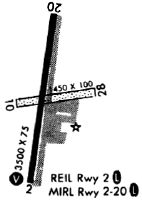
| Runways: | 02/20 |
| Longest Runway: | 02/20 is 3501 ft (1067 m) long |
| Runways with an Instrument Approach: |
3B0 Airport Runway Details
| Runway 02/20 | 3501 ft x 75 ft (1067 m x 23 m) | |
| Runway Length Source: | NGS as of 08/31/2007 | |
| Surface: | Asphalt - Good condition - No special surface treatment | |
| Runway Edge Lights: | Medium Intensity | |
Runway Weight Bearing Capacity (in thousands of pounds) |
||
| Single Wheel Landing Gear: | 28.0 | |
Runway 02 |
Runway 20 |
|
Elevation: |
689.0 | 698.8 |
Latitude: |
42-05-46.8699N | 42-06-21.1226N |
Longitude: |
072-02-23.0285W | 072-02-16.5979W |
|
Runway True Alignment: |
008 | 188 |
Glide Path Angle: |
3.0 degrees | 3.5 degrees |
Traffic Pattern: |
Left | Left |
Runway Markings Type: |
Nonprecision Instrument | Basic |
Runway Markings Condition: |
Good | Good |
Object at End: |
TREES | TREES |
Object Height: |
23 | 52 |
Distance from End: |
1000 | 2000 |
Object Centerline Offset: |
125 ft. right of centerline | |
Visual Glide Slope Indicators: |
4-Light PAPI On Left Side Of Runway | 4-Light PAPI On Left Side Of Runway |
REIL: |
Yes | Yes |
Threshold Crossing Height: |
40 | 45 |
Services
Airframe Repair: |
Major |
Powerplant Repair: |
Major |
Bottled Oxygen: |
None |
Bulk Oxygen: |
None |
Fuel Available: |
100LL, Jet A-1 |
Landing Fees: |
No |
Parking: |
Hangars and tiedowns available |
Maps & Diagrams
3B0 Sectional
Flight Planning
at skyvector.com
at skyvector.com