Location
Latitude: |
42-16-01.7000N (42.267139) |
Longitude: |
071-52-32.2000W (-71.875611) |
Elevation: |
1009.0 feet MSL (308 m MSL) |
Magnetic Variation: |
13.8 W (as of April 2024 from WMM2020 model) |
Time Zone: |
UTC -5.0 (Standard Time) UTC -4.0 (Daylight Savings Time) |
From City: |
03 N.M. W of Worcester, Massachusetts |
Found On: |
New York Chart |
FAA Region: |
ANE |
Contacts
Manager: |
Publicly owned: |
| ANDREW B DAVIS WORCESTER REGIONAL AIRPORT, 5 AIRPORT DR WORCESTER, MA 01602 508-849-5550 |
MASS PORT AUTHORITY 375 AIRPORT DR WORCESTER, MA 01602 508-849-5550 |
Operations
Airport Status: |
Operational |
Facility Use: |
Public |
Type: |
Airport |
Activation Date: |
02/1946 |
Control tower: |
Yes |
Attendance (Months/Days/Hours): |
Months/Days/Hours ALL/ALL/ALL |
Boundary ARTCC: |
ZBW (Boston) |
Responsible ARTCC: |
ZBW (Boston) |
Lighting Schedule: |
SEE RMK |
Segmented Circle Indicator: |
Yes |
Traffic Pattern Altitude (MSL): |
2009 feet (612 m) |
NOTAMs Facility: |
ORH |
NOTAM-D Service: |
Yes |
International Airport of Entry: |
No |
Customs Landing Rights: |
Yes |
Military Landing Rights: |
Yes |
Civil/Military Joint Use: |
No |
Aircraft Rescue and Firefighting: |
Class I ARFF Index: B Air Carrier Service: Scheduled Certification Date: 05/1973 |
Based Aircraft
| Single Engine: | 49 |
| Multi Engine: | 3 |
| Jet Engine: | 2 |
| Gliders: | 1 |
Annual Operations (as of 03/31/2023)
| Total Operations: | 24376 | |
| Commercial: | 3316 | 13.6% |
| Air Taxi: | 3004 | 12.3% |
| GA Local: | 6518 | 26.7% |
| GA Itinerant: | 10564 | 43.3% |
| Military Aircraft: | 974 | 4.0% |
Communications
| CTAF: | 120.500 |
| Unicom: | 122.950 |
| Tower: | WORCESTER 120.5 263.0 Hrs: 0630-2100 |
| Clearance Del.: | 128.65 |
| Ground: | 123.85 |
| Approach: | BRADLEY 119.0 119.0 119.0 119.0 119.0 |
| Departure: | BRADLEY 119.0 119.0 119.0 119.0 119.0 |
| ATIS: | 126.55 Hrs: 24 |
| ASOS: | (508-795-7546) |
| EMERG: | 121.5 |
| EMERG: | 243.0 |
Fixed Based Operators (FBOs) & Fuel
(Click on a business for detail)
Please help us keep this information up to date. This is a FREE SERVICE just like everything else on Airport Guide! If you see that a business needs to be added, modified, or deleted please fill out our Update Form.
To add, modify, or delete a business click here.
Please help us keep this information up to date. This is a FREE SERVICE just like everything else on Airport Guide! If you see that a business needs to be added, modified, or deleted please fill out our Update Form.
Area Code: 508 |
| Business Name | Frequency | Phone | Fuel Grade |
|---|---|---|---|
| Aero Connection Flight Academy
Update FBO info |
752-5299 | ||
| Amity Flight School
Update FBO info |
756-7703 | ||
| DynAir Fueling, Inc.
Update FBO info |
Unicom 122.95 | 755-5870 | 100LL, Jet A |
| Radio Shop, Inc.
Update FBO info |
757-6954 |
Flight Service Stations
| Primary | Alternate | |
| FSS on Field: | N | |
| FSS Name (ID): | Bridgeport(BDR) | |
| Frequency: | ||
| Toll Free Phone: | 1-800-WX-BRIEF |
Instrument Procedures / Charts
FAA Terminal Procedures valid from 0901Z 03/21/24 to 0901Z 04/18/24.
There are various types of charts available for an airport. They are listed in the Page Type column. Here is a legend for those types:
APD - Airport Diagram
DP - Departure Procedure Charts
HOT - Hot Spots
IAP - Instrument Approach Procedure Charts
MIN - Minimums
STAR - Standard Terminal Arrival Charts
| Page Type | Page Name | Volume | Action Since Last Cycle |
|---|---|---|---|
| APD | AIRPORT DIAGRAM | NE-1 | |
| IAP | ILS OR LOC RWY 11 | NE-1 | |
| IAP | ILS OR LOC RWY 29 | NE-1 | |
| IAP | ILS RWY 11 (CAT II - III) | NE-1 | |
| IAP | RNAV (GPS) RWY 11 | NE-1 | |
| IAP | RNAV (GPS) RWY 29 | NE-1 | |
| IAP | RNAV (GPS) RWY 33 | NE-1 | |
| IAP | VOR/DME RWY 33 | NE-1 | |
| MIN | ALTERNATE MINIMUMS | NE-1 | |
| MIN | TAKEOFF MINIMUMS | NE-1 | Changed |
| STAR | STELA ONE | NE-1 | |
| STAR | STELA ONE[DELIMITER] CONT.1 | NE-1 |
Terminal Procedures are only available for airports in several countries with more being added all the time. If you are looking for a specific country's charts, please send an email to support(at)airportguide.com stating the country name. This will be used to prioritize the implementation.
Navigation Aids (Navaids) near ORH
| Dist (NM) | ID | Morse Code | Name | Type | Freq | True Hdg | Mag Hdg |
|---|---|---|---|---|---|---|---|
| 0.3 | ORH | _ _ _ . _ . . . . . | Worcester | VOT | 108.20 | 92 | 106 |
| 17.8 | FIT | . . _ . . . _ | Fitchburg | NDB | 365 | 17 | 31 |
| 18.6 | GDM | _ _ . _ . . _ _ | Gardner | VOR-DME | 110.60 | 334 | 348 |
| 18.8 | PUT | . _ _ . . . _ _ | Putnam | VOR-DME | 117.40 | 175 | 189 |
| 25.1 | BE | _ . . . . | Bedds | NDB | 332 | 59 | 73 |
| 25.6 | ORE | _ _ _ . _ . . | Orange | NDB | 205 | 314 | 328 |
| 28.6 | BED | _ . . . . _ . . | Bedford | VOT | 110.00 | 65 | 79 |
| 29.2 | CEF | _ . _ . . . . _ . | Westover | TACAN | 114.00 | 261 | 275 |
| 32.9 | SKR | . . . _ . _ . _ . | Shaker Hill | NDB | 251 | 69 | 83 |
| 34.1 | IHM | . . . . . . _ _ | Mansfield | NDB | 220 | 117 | 131 |
| 34.4 | OW | _ _ _ . _ _ | Stoge | NDB | 397 | 104 | 118 |
| 35.5 | AS | . _ . . . | Chern | NDB | 359 | 19 | 33 |
| 36.0 | AR | . _ . _ . | Armin | NDB | 356 | 139 | 153 |
| 36.6 | EEN | . . _ . | Keene | DME | 109.4 | 329 | 343 |
| 37.6 | LW | . _ . . . _ _ | Haget | NDB | 402 | 52 | 66 |
| 37.9 | BAF | _ . . . . _ . . _ . | Barnes | VORTAC | 113.00 | 260 | 274 |
| 38.2 | PVD | . _ _ . . . . _ _ . . | Providence | VOR-DME | 115.60 | 148 | 162 |
| 38.3 | PVD | . _ _ . . . . _ _ . . | Providence | VOT | 108.20 | 148 | 162 |
| 39.0 | MJ | _ _ . _ _ _ | Fitzy | NDB | 209 | 23 | 37 |
| 39.7 | BOS | _ . . . _ _ _ . . . | Boston | VOT | 111.00 | 81 | 95 |
Nearby Airports with Fuel
Notices to Airmen (NOTAMS)
Remarks
| A110-1 | WILDLIFE & BIRDS ON & INVOF ARPT. |
| A110-2 | DURG SN REMOVAL OPS, 30 MIN PPR, FREQ 120.50 DURG TWR HRS, FREQ 119.0 DURG NON-TWR HRS OR CALL 508-799-1325. |
| A110-4 | USE CTN FOR ARPT VEHICLES MNT CTAF & OPERG ON ARPT DURG NON-TWR HRS. |
| A110-5 | TSNT ACFT CTC FBO ON 122.95 FOR SVCS. |
| A110-6 | RWY GUARD LGTS INSTLD ON ALL TWY TO RWY INTXNS, RWY 11/29 ONLY. |
| A24 | LDG FEE FOR MULTI-ENG ACFT & LRGR. |
| A43-15 | RWY 15 VASI UNUSBL BYD 9 DEG L OF CRS. |
| A49-11 | RWY 11 ALSF-2 BECOMES SSALS PRESET ON MED INTST ONLY WHEN TWR CLSD. |
| A81-APT | ACTVT REIL RWY 15, 29 & 33; HIRL RWY 11/29; MIRL RWY 15/33 - CTAF. |
| E111 | FILED FOR RECORD PURPOSES ONLY. |
| E60-11 | ENGRD MTRLS ARST SYS 170 FT WID, 154 FT LEN, LCTD AT DER 11. |
| E60-29 | ENGRD MTRLS ARST SYS 170 FT WID, 300 FT LEN, LCTD AT DER 29. |
| E80 | 2 HRS ADVN NOTICE RQRD FOR CUST. |
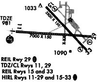
Runways
Runway Summary
| Runways: | 11/29 15/33 |
| Longest Runway: | 11/29 is 7001 ft (2134 m) long |
| Runways with an Instrument Approach: | 11, 29 |
ORH Airport Runway Details
| Runway 11/29 | 7001 ft x 150 ft (2134 m x 46 m) | |
| Runway Length Source: | 3RD PARTY SURVEY as of 05/18/2010 | |
| Surface: | Asphalt - Excellent condition - Saw-cut or plastic grooved | |
| Runway Pavement Class: | 89 /F/C/W/T | |
| Runway Edge Lights: | High Intensity | |
Runway Weight Bearing Capacity (in thousands of pounds) |
||
| Single Wheel Landing Gear: | 120.0 | |
| Dual Wheel Landing Gear: | 250.0 | |
| Dual Tandem Wheel Landing Gear: | 550.0 | |
Runway 11 |
Runway 29 |
|
Elevation: |
980.0 | 987.9 |
Latitude: |
42-16-02.3866N | 42-15-57.7511N |
Longitude: |
071-53-26.8657W | 071-51-53.9652W |
|
Runway True Alignment: |
094 | 274 |
ILS Type: |
ILS/DME | ILS/DME |
Glide Path Angle: |
3.0 degrees | 3.0 degrees |
Traffic Pattern: |
Left | Left |
Runway Markings Type: |
Precision Instrument | Precision Instrument |
Runway Markings Condition: |
Good | Good |
Arresting Device: |
EMAS | EMAS |
Object at End: |
HILL | |
Object Height: |
110 | |
Distance from End: |
4500 | |
Object Centerline Offset: |
0 ft. left and right of centerline | |
Visual Glide Slope Indicators: |
4-Light PAPI On Right Side Of Runway | 4-Light PAPI On Left Side Of Runway |
Runway Visual Range (RVR): |
Touchdown, Rollout | Touchdown, Rollout |
Approach Light System: |
Standard 2,400 Foot High Intensity Approach Lighting System With Sequenced Flashers, Cat. II or III Config. | |
REIL: |
No | Yes |
Touchdown Lights: |
Yes | No |
Centerline Lights: |
Yes | Yes |
Threshold Crossing Height: |
55 | 54 |
Declared Distances |
||
Take Off Run Avbl. (TORA): |
7001 | 7001 |
Take Off Distance Avbl. (TODA): |
7001 | 7001 |
Actual Stop Dist. Avbl. (ASDA): |
7001 | 7001 |
Landing Dist. Avbl. (LDA): |
7001 | 7001 |
| Runway 15/33 | 5000 ft x 100 ft (1524 m x 30 m) | |
| Runway Length Source: | 3RD PARTY SURVEY as of 05/18/2010 | |
| Surface: | Asphalt - Excellent condition - Saw-cut or plastic grooved | |
| Runway Pavement Class: | 35 /F/C/W/T | |
| Runway Edge Lights: | Medium Intensity | |
Runway Weight Bearing Capacity (in thousands of pounds) |
||
| Single Wheel Landing Gear: | 85.0 | |
| Dual Wheel Landing Gear: | 120.0 | |
| Dual Tandem Wheel Landing Gear: | 210.0 | |
Runway 15 |
Runway 33 |
|
Elevation: |
1008.9 | 997.9 |
Latitude: |
42-16-22.2435N | 42-15-45.6872N |
Longitude: |
071-52-43.1427W | 071-51-58.4327W |
|
Runway True Alignment: |
138 | 318 |
Glide Path Angle: |
3.6 degrees | 3.0 degrees |
Traffic Pattern: |
Left | Left |
Runway Markings Type: |
Basic | Nonprecision Instrument |
Runway Markings Condition: |
Good | Good |
Object at End: |
ANT | |
Object Height: |
252 | |
Distance from End: |
14000 | |
Object Centerline Offset: |
0 ft. left and right of centerline | |
Visual Glide Slope Indicators: |
4-Box VASI On Left Side Of Runway | 4-Light PAPI On Left Side Of Runway |
REIL: |
Yes | Yes |
Touchdown Lights: |
No | No |
Centerline Lights: |
No | No |
Threshold Crossing Height: |
42 | 40 |
Declared Distances |
||
Take Off Run Avbl. (TORA): |
5000 | 5000 |
Take Off Distance Avbl. (TODA): |
5000 | 5000 |
Actual Stop Dist. Avbl. (ASDA): |
5000 | 5000 |
Landing Dist. Avbl. (LDA): |
5000 | 5000 |
Services
Airframe Repair: |
Major |
Powerplant Repair: |
Major |
Bottled Oxygen: |
None |
Bulk Oxygen: |
None |
Fuel Available: |
100LL |
Landing Fees: |
No |
Parking: |
Hangars and tiedowns available |
Maps & Diagrams
ORH Sectional
Flight Planning
at skyvector.com
at skyvector.com