Location
Latitude: |
35-49-12.8000N (35.820222) |
Longitude: |
081-36-41.1000W (-81.611417) |
Elevation: |
1269.9 feet MSL (387 m MSL) |
Magnetic Variation: |
7.6 W (as of April 2024 from WMM2020 model) |
Time Zone: |
UTC -5.0 (Standard Time) UTC -4.0 (Daylight Savings Time) |
From City: |
06 N.M. NE of Morganton, North Carolina |
Found On: |
Charlotte Chart |
FAA Region: |
ASO |
Contacts
Manager: |
Publicly owned: |
| BRENT BRINKLEY 3566 FOOTHILLS AIRPORT RD MORGANTON, NC 28655 828-757-0099 |
FOOTHILLS REGIONAL AIRPORT AUTHORIT 3566 FOOTHILLS AIRPORT RD MORGANTON, NC 28655 828-757-0099 |
Operations
Airport Status: |
Operational |
Facility Use: |
Public |
Type: |
Airport |
Activation Date: |
12/1945 |
Control tower: |
No |
Attendance (Months/Days/Hours): |
Months/Days/Hours ALL/MON-SAT/0800-1700 |
Boundary ARTCC: |
ZTL (Atlanta) |
Responsible ARTCC: |
ZTL (Atlanta) |
Lighting Schedule: |
SEE RMK |
Segmented Circle Indicator: |
Yes |
Traffic Pattern Altitude (MSL): |
2270 feet (692 m) |
NOTAMs Facility: |
MRN |
NOTAM-D Service: |
Yes |
International Airport of Entry: |
No |
Customs Landing Rights: |
No |
Military Landing Rights: |
Yes |
Civil/Military Joint Use: |
No |
Based Aircraft
| Single Engine: | 53 |
| Multi Engine: | 3 |
Annual Operations (as of 07/03/2023)
| Total Operations: | 17000 | |
| Air Taxi: | 1000 | 5.9% |
| GA Local: | 9000 | 52.9% |
| GA Itinerant: | 6500 | 38.2% |
| Military Aircraft: | 500 | 2.9% |
Communications
| CTAF: | 122.700 |
| Unicom: | 122.700 |
| AWOS-3P: | 124.175 (828-757-0788) |
- APCH/DEP SVC PRVDD BY ATLANTA ARTCC (ZTL) ON FREQS 125.15/263.0 (HICKORY RCAG).
Fixed Based Operators (FBOs) & Fuel
(Click on a business for detail)
Please help us keep this information up to date. This is a FREE SERVICE just like everything else on Airport Guide! If you see that a business needs to be added, modified, or deleted please fill out our Update Form.
To add, modify, or delete a business click here.
Please help us keep this information up to date. This is a FREE SERVICE just like everything else on Airport Guide! If you see that a business needs to be added, modified, or deleted please fill out our Update Form.
Area Code: 828 |
| Business Name | Frequency | Phone | Fuel Grade |
|---|---|---|---|
| Avtec Services, Inc.
Update FBO info |
Unicom 122.7 | 757-0099, 437-9834 | 100LL, Jet A |
Flight Service Stations
| Primary | Alternate | |
| FSS on Field: | N | |
| FSS Name (ID): | Raleigh(RDU) | |
| Frequency: | ||
| Toll Free Phone: | 1-800-WX-BRIEF |
Instrument Procedures / Charts
FAA Terminal Procedures valid from 0901Z 03/21/24 to 0901Z 04/18/24.
There are various types of charts available for an airport. They are listed in the Page Type column. Here is a legend for those types:
APD - Airport Diagram
DP - Departure Procedure Charts
HOT - Hot Spots
IAP - Instrument Approach Procedure Charts
MIN - Minimums
STAR - Standard Terminal Arrival Charts
| Page Type | Page Name | Volume | Action Since Last Cycle |
|---|---|---|---|
| IAP | LOC RWY 03 | SE-2 | |
| IAP | RNAV (GPS) RWY 03 | SE-2 | |
| IAP | RNAV (GPS) RWY 21 | SE-2 | |
| MIN | ALTERNATE MINIMUMS | SE-2 | |
| MIN | TAKEOFF MINIMUMS | SE-2 |
Terminal Procedures are only available for airports in several countries with more being added all the time. If you are looking for a specific country's charts, please send an email to support(at)airportguide.com stating the country name. This will be used to prioritize the implementation.
Navigation Aids (Navaids) near MRN
| Dist (NM) | ID | Morse Code | Name | Type | Freq | True Hdg | Mag Hdg |
|---|---|---|---|---|---|---|---|
| 1.6 | MRN | _ _ . _ . _ . | Lenoir | FAN MARKER | 203 | 211 | |
| 7.2 | FIQ | . . _ . . . _ _ . _ | Fiddlers | NDB | 391 | 203 | 211 |
| 11.8 | HKY | . . . . _ . _ _ . _ _ | Hickory Regional | VOT | 110.00 | 113 | 121 |
| 15.0 | HK | . . . . _ . _ | Tawba | NDB | 332 | 97 | 105 |
| 18.3 | BZM | _ . . . _ _ . . _ _ | Barretts Mountain | VOR-DME | 113.75 | 80 | 88 |
| 23.9 | BAR | _ . . . . _ . _ . | Hemlock | NDB | 320 | 326 | 334 |
| 30.5 | UKF | . . _ _ . _ . . _ . | Wilki | NDB | 209 | 54 | 62 |
| 30.7 | IZN | . . _ _ . . _ . | Lincolnton | NDB | 432 | 123 | 131 |
| 34.1 | SLP | . . . . _ . . . _ _ . | First River | NDB | 417 | 178 | 186 |
| 39.4 | JUH | . _ _ _ . . _ . . . . | Ashee | NDB | 410 | 20 | 28 |
| 40.5 | SUG | . . . . . _ _ _ . | Sugarloaf Mountain | VORTAC | 112.20 | 232 | 239 |
| 43.7 | EZT | . _ _ . . _ | Elizabethton | NDB | 275 | 313 | 320 |
| 43.7 | GHJ | _ _ . . . . . . _ _ _ | Stonia | NDB | 260 | 149 | 157 |
| 44.7 | HMV | . . . . _ _ . . . _ | Holston Mountain | VORTAC | 114.60 | 325 | 332 |
| 47.9 | CLT | _ . _ . . _ . . _ | Charlotte | VOT | 112.00 | 137 | 145 |
| 49.7 | SPA | . . . . _ _ . . _ | Spartanburg | VORTAC | 115.70 | 198 | 205 |
| 49.7 | CLT | _ . _ . . _ . . _ | Charlotte | VOR-DME | 115.00 | 139 | 147 |
| 50.6 | IM | . . _ _ | Keans | NDB | 357 | 250 | 257 |
| 52.0 | ZEF | _ _ . . . . . _ . | Zephyr | NDB | 326 | 55 | 63 |
| 53.3 | BRA | _ . . . . _ . . _ | Broad River | NDB | 379 | 232 | 239 |
Nearby Airports with Fuel
Notices to Airmen (NOTAMS)
Remarks
| A110-10 | APRON TIE DOWN SPACE LTD. |
| A110-5 | RY 03, 100 FT DROPOFF 330 FT FM THLD AND 80 FT BOTH SIDES OF CNTRLN ALONG FIRST 1000 FT OF RY. |
| A110-6 | RY 21, 30 FT DROPOFF 400 FT FM THLD BOTH SIDES AND 10 FT DROPOFF 50 FT FM THLD AND 150 FT RIGHT OF CNTRLN. |
| A110-7 | HANG GLIDER ACT DALGT HRS - EAST SIDE OF RWY 03/21 IN RWY SAFETY AREA. |
| A110-8 | DEER & COYOTE ON & INVOF ARPT. |
| A110-9 | FOR CD CTC ATLANTA ARTCC AT 770-210-7692. |
| A70-FUEL-10 | 0LL AFTER HOURS FUEL OR SERVICE CALL 828-757-0099 |
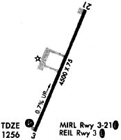
| A81-APT | ACTVT REILS RWY 03 & 21; PAPI RWY 03 & 21; MIRL RWY 03/21 - CTAF. |
Runways
Runway Summary
| Runways: | 03/21 |
| Longest Runway: | 03/21 is 5500 ft (1676 m) long |
| Runways with an Instrument Approach: | 03 |
MRN Airport Runway Details
| Runway 03/21 | 5500 ft x 75 ft (1676 m x 23 m) | |
| Runway Length Source: | 3RD PARTY SURVEY as of 12/16/2014 | |
| Surface: | Asphalt - Good condition - No special surface treatment | |
| Runway Edge Lights: | Medium Intensity | |
Runway Weight Bearing Capacity (in thousands of pounds) |
||
| Dual Wheel Landing Gear: | 60.0 | |
Runway 03 |
Runway 21 |
|
Elevation: |
1230.2 | 1269.7 |
Latitude: |
35-48-47.9231N | 35-49-37.7525N |
Longitude: |
081-36-54.4494W | 081-36-27.7087W |
|
Runway True Alignment: |
024 | 204 |
ILS Type: |
LOCALIZER | |
Glide Path Angle: |
3.0 degrees | 3.5 degrees |
Traffic Pattern: |
Left | Left |
Runway Markings Type: |
Nonprecision Instrument | Nonprecision Instrument |
Runway Markings Condition: |
Good | Good |
Object at End: |
TREES | TREES |
Object Height: |
10 | 16 |
Distance from End: |
612 | 548 |
Object Centerline Offset: |
306 ft. left of centerline | 237 ft. left of centerline |
Visual Glide Slope Indicators: |
4-Light PAPI On Left Side Of Runway | 4-Light PAPI On Right Side Of Runway |
REIL: |
Yes | Yes |
Touchdown Lights: |
No | No |
Centerline Lights: |
No | No |
Threshold Crossing Height: |
66 | 48 |
Services
Airframe Repair: |
None |
Powerplant Repair: |
None |
Bottled Oxygen: |
None |
Bulk Oxygen: |
None |
Fuel Available: |
100LL |
Landing Fees: |
No |
Parking: |
Tiedowns available |
Maps & Diagrams
MRN Sectional
Flight Planning
at skyvector.com
at skyvector.com