Location
Latitude: |
39-41-53.5000N (39.698194) |
Longitude: |
085-07-52.1000W (-85.131139) |
Elevation: |
866.3 feet MSL (264 m MSL) |
Magnetic Variation: |
5.7 W (as of April 2024 from WMM2020 model) |
Time Zone: |
UTC -5.0 (Standard Time) UTC -4.0 (Daylight Savings Time) |
From City: |
03 N.M. N of Connersville, Indiana |
Found On: |
St Louis Chart |
FAA Region: |
AGL |
Contacts
Manager: |
Publicly owned: |
| JEFF DUNGAN 500 AIRPORT DRIVE CONNERSVILLE, IN 47331 (765) 825-5581 |
CONNERSVILLE BOAC 500 AIRPORT DRIVE CONNERSVILLE, IN 47331 765-825-5581 |
Operations
Airport Status: |
Operational |
Facility Use: |
Public |
Type: |
Airport |
Activation Date: |
02/1946 |
Control tower: |
No |
Attendance (Months/Days/Hours): |
Months/Days/Hours ALL/ALL/0800-1700 |
Boundary ARTCC: |
ZID (Indianapolis) |
Responsible ARTCC: |
ZID (Indianapolis) |
Lighting Schedule: |
SEE RMK |
Segmented Circle Indicator: |
No |
Traffic Pattern Altitude (MSL): |
1866 feet (569 m) |
NOTAMs Facility: |
HUF |
NOTAM-D Service: |
Yes |
International Airport of Entry: |
No |
Customs Landing Rights: |
No |
Military Landing Rights: |
Yes |
Civil/Military Joint Use: |
No |
Based Aircraft
| Single Engine: | 12 |
| Multi Engine: | 1 |
Annual Operations (as of 12/31/2022)
| Total Operations: | 8272 | |
| Air Taxi: | 249 | 3.0% |
| GA Local: | 3698 | 44.7% |
| GA Itinerant: | 4285 | 51.8% |
| Military Aircraft: | 40 | 0.5% |
Communications
| CTAF: | 122.800 |
| Unicom: | 122.800 |
| Approach: | COLUMBUS 118.425 118.425 118.425 |
| Departure: | COLUMBUS 118.425 118.425 118.425 |
| AWOS-3: | 118.325 (765-827-6649) |
Fixed Based Operators (FBOs) & Fuel
(Click on a business for detail)
Please help us keep this information up to date. This is a FREE SERVICE just like everything else on Airport Guide! If you see that a business needs to be added, modified, or deleted please fill out our Update Form.
To add, modify, or delete a business click here.
Please help us keep this information up to date. This is a FREE SERVICE just like everything else on Airport Guide! If you see that a business needs to be added, modified, or deleted please fill out our Update Form.
Area Code: 937 |
| Business Name | Frequency | Phone | Fuel Grade |
|---|---|---|---|
| Rose City Aviation, Inc.
Update FBO info |
Unicom 122.8 | 827-1529, 825-5581 | 100LL, Jet A |
Flight Service Stations
| Primary | Alternate | |
| FSS on Field: | N | |
| FSS Name (ID): | Terre Haute(HUF) | |
| Frequency: | ||
| Toll Free Phone: | 1-800-WX-BRIEF |
Instrument Procedures / Charts
FAA Terminal Procedures valid from 0901Z 03/21/24 to 0901Z 04/18/24.
There are various types of charts available for an airport. They are listed in the Page Type column. Here is a legend for those types:
APD - Airport Diagram
DP - Departure Procedure Charts
HOT - Hot Spots
IAP - Instrument Approach Procedure Charts
MIN - Minimums
STAR - Standard Terminal Arrival Charts
| Page Type | Page Name | Volume | Action Since Last Cycle |
|---|---|---|---|
| IAP | ILS OR LOC RWY 18 | EC-2 | |
| IAP | RNAV (GPS) RWY 18 | EC-2 | |
| IAP | RNAV (GPS) RWY 36 | EC-2 | |
| MIN | TAKEOFF MINIMUMS | EC-2 |
Terminal Procedures are only available for airports in several countries with more being added all the time. If you are looking for a specific country's charts, please send an email to support(at)airportguide.com stating the country name. This will be used to prioritize the implementation.
Navigation Aids (Navaids) near CEV
| Dist (NM) | ID | Morse Code | Name | Type | Freq | True Hdg | Mag Hdg |
|---|---|---|---|---|---|---|---|
| 4.7 | SQ | . . . _ _ . _ | Pnthr | NDB | 227 | 0 | 6 |
| 13.9 | RID | . _ . . . _ . . | Richmond | DME | 110.6 | 75 | 81 |
| 13.9 | UWL | . . _ . _ _ . _ . . | New Castle | NDB | 385 | 321 | 327 |
| 19.8 | OXD | _ _ _ _ . . _ _ . . | Oxford | NDB | 282 | 125 | 131 |
| 21.9 | HLB | . . . . . _ . . _ . . . | Batesville | NDB | 254 | 195 | 201 |
| 28.3 | AI | . _ . . | Video | NDB | 394 | 322 | 328 |
| 30.3 | JN | . _ _ _ _ . | Balll | NDB | 365 | 343 | 349 |
| 32.3 | SHB | . . . . . . . _ . . . | Shelbyville | VOR-DME | 116.15 | 263 | 268 |
| 32.4 | HAO | . . . . . _ _ _ _ | Hamilton | NDB | 260 | 126 | 132 |
| 33.8 | HKF | . . . . _ . _ . . _ . | Hook Field | NDB | 239 | 110 | 116 |
| 34.5 | MIE | _ _ . . . | Muncie | VOR-DME | 114.40 | 339 | 345 |
| 37.8 | AT | . _ _ | Bruny | NDB | 315 | 76 | 82 |
| 38.0 | MW | _ _ . _ _ | Onida | NDB | 223 | 100 | 106 |
| 38.8 | DQN | _ . . _ _ . _ _ . | Dayton | VOR-DME | 114.50 | 60 | 66 |
| 39.0 | BA | _ . . . . _ | Clifs | NDB | 410 | 234 | 239 |
| 42.5 | UR | . . _ . _ . | Burln | NDB | 321 | 156 | 162 |
| 43.9 | DAY | _ . . . _ _ . _ _ | Dayton J M Cox-Day | VOT | 111.00 | 73 | 79 |
| 44.5 | HFY | . . . . . . _ . _ . _ _ | Greenwood | NDB | 398 | 265 | 270 |
| 44.7 | UMP | . . _ _ _ . _ _ . | Metropolitan | NDB | 338 | 289 | 294 |
| 45.5 | CVG | _ . _ . . . . _ _ _ . | Cincinnati | VORTAC | 117.30 | 153 | 159 |
Nearby Airports with Fuel
Notices to Airmen (NOTAMS)
Remarks
| A110-1 | BIRDS & DEER ON & INVOF ARPT. |
| A110-2 | COLUMBUS APCH CD (614) 338-8537. |
| A17 | AFT HR SVC - 765-969-2586. |
| A70-FUEL-10 | 0LL SELF SVC H24. |
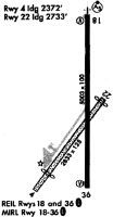
| A81-APT | ACTVT MALSR RWY 18; REIL RWY 18 & 36; MIRL RWY 18/36 - CTAF. MIRL RWY 18/36 PRESET LOW INTST; INCR INTST - CTAF. |
Runways
Runway Summary
| Runways: | 04/22 18/36 |
| Longest Runway: | 18/36 is 6503 ft (1982 m) long |
| Runways with an Instrument Approach: | 18 |
CEV Airport Runway Details
| Runway 04/22 | 2601 ft x 100 ft (793 m x 30 m) | |
| Runway Length Source: | 3RD PARTY SURVEY as of 09/09/2009 | |
| Surface: | Turf - Good condition - No special surface treatment | |
Runway 04 |
Runway 22 |
|
Elevation: |
861.5 | 857.8 |
Latitude: |
39-41-40.5196N | 39-42-01.1225N |
Longitude: |
085-08-05.0248W | 085-07-45.1297W |
|
Runway True Alignment: |
036 | 216 |
Glide Path Angle: |
0.0 degrees | 0.0 degrees |
Traffic Pattern: |
Left | Left |
Runway Markings Type: |
None | None |
REIL: |
No | No |
Touchdown Lights: |
No | No |
Centerline Lights: |
No | No |
| Runway 18/36 | 6503 ft x 100 ft (1982 m x 30 m) | |
| Runway Length Source: | 3RD PARTY SURVEY as of 09/09/2009 | |
| Surface: | Turf - Good condition - Saw-cut or plastic grooved | |
| Runway Edge Lights: | Medium Intensity | |
Runway Weight Bearing Capacity (in thousands of pounds) |
||
| Single Wheel Landing Gear: | 50.0 | |
| Dual Wheel Landing Gear: | 84.0 | |
Runway 18 |
Runway 36 |
|
Elevation: |
866.2 | 862.0 |
Latitude: |
39-42-26.7575N | 39-41-22.4946N |
Longitude: |
085-07-50.4894W | 085-07-51.2558W |
|
Runway True Alignment: |
180 | 360 |
ILS Type: |
ILS | |
Glide Path Angle: |
3.0 degrees | 3.0 degrees |
Traffic Pattern: |
Left | Left |
Runway Markings Type: |
Precision Instrument | Nonprecision Instrument |
Runway Markings Condition: |
Fair | Fair |
Object at End: |
TREES | |
Object Height: |
90 | |
Distance from End: |
3340 | |
Visual Glide Slope Indicators: |
4-Light PAPI On Left Side Of Runway | 4-Light PAPI On Left Side Of Runway |
Approach Light System: |
1,400 Foot Medium Intensity Approach Lighting System With Runway Alignment Indicator Lights | |
REIL: |
Yes | Yes |
Touchdown Lights: |
No | No |
Centerline Lights: |
No | No |
Threshold Crossing Height: |
47 | 34 |
Services
Airframe Repair: |
Major |
Powerplant Repair: |
Major |
Bottled Oxygen: |
None |
Bulk Oxygen: |
High Pressure |
Fuel Available: |
100LL, Jet A |
Landing Fees: |
No |
Parking: |
Tiedowns available |
Maps & Diagrams
CEV Sectional
Flight Planning
at skyvector.com
at skyvector.com