Location
Latitude: |
37-27-20.0660N (37.455574) |
Longitude: |
097-50-01.1940W (-97.833665) |
Elevation: |
1494.0 feet MSL (455 m MSL) |
Magnetic Variation: |
3.4 E (as of April 2024 from WMM2020 model) |
Time Zone: |
UTC -6.0 (Standard Time) UTC -5.0 (Daylight Savings Time) |
From City: |
01 N.M. E of Norwich, Kansas |
Found On: |
Wichita Chart |
FAA Region: |
ACE |
Contacts
Manager: |
Publicly owned: |
| MONTE VAVRA CITY HALL NORWICH, KS 67118 620-704-3339 |
CITY OF NORWICH CITY HALL NORWICH, KS 67118 620-478-2278 |
Operations
Airport Status: |
Operational |
Facility Use: |
Public |
Type: |
Airport |
Activation Date: |
01/1971 |
Control tower: |
No |
Attendance (Months/Days/Hours): |
Months/Days/Hours Unattended |
Boundary ARTCC: |
ZKC (Kansas City) |
Responsible ARTCC: |
ZKC (Kansas City) |
Lighting Schedule: |
SS-SR |
Segmented Circle Indicator: |
No |
Traffic Pattern Altitude (MSL): |
2494 feet (760 m) |
NOTAMs Facility: |
ICT |
NOTAM-D Service: |
Yes |
Based Aircraft
| Single Engine: | 6 |
| Ultralights: | 2 |
Annual Operations (as of 04/30/2021)
| Total Operations: | 470 | |
| GA Local: | 400 | 85.1% |
| GA Itinerant: | 70 | 14.9% |
Communications
| CTAF: | 122.900 |
Fixed Based Operators (FBOs) & Fuel
(Click on a business for detail)
Please help us keep this information up to date. This is a FREE SERVICE just like everything else on Airport Guide! If you see that a business needs to be added, modified, or deleted please fill out our Update Form.
To add, modify, or delete a business click here.
Please help us keep this information up to date. This is a FREE SERVICE just like everything else on Airport Guide! If you see that a business needs to be added, modified, or deleted please fill out our Update Form.
Area Code: 620 |
| Business Name | Frequency | Phone | Fuel Grade |
|---|
Flight Service Stations
| Primary | Alternate | |
| FSS on Field: | N | |
| FSS Name (ID): | Wichita(ICT) | |
| Frequency: | ||
| Toll Free Phone: | 1-800-WX-BRIEF |
Instrument Procedures / Charts
Terminal Procedures are only available for airports in several countries with more being added all the time. If you are looking for a specific country's charts, please send an email to support(at)airportguide.com stating the country name. This will be used to prioritize the implementation.
Navigation Aids (Navaids) near 49K
| Dist (NM) | ID | Morse Code | Name | Type | Freq | True Hdg | Mag Hdg |
|---|---|---|---|---|---|---|---|
| 19.4 | IC | . . _ . _ . | Piche | NDB | 332 | 67 | 64 |
| 21.1 | ICT | . . _ . _ . _ | Wichita | VORTAC | 113.80 | 34 | 31 |
| 21.9 | ICT | . . _ . _ . _ | Wichita | VOT | 114.00 | 60 | 57 |
| 22.6 | EGT | . _ _ . _ | Wellington | NDB | 414 | 110 | 107 |
| 24.0 | ANY | . _ _ . _ . _ _ | Anthony | TACAN | 112.90 | 222 | 219 |
| 28.7 | IAB | . . . _ _ . . . | Mc Connell | TACAN | 116.50 | 69 | 66 |
| 32.8 | HUT | . . . . . . _ _ | Hutchinson | VOR-DME | 116.80 | 351 | 348 |
| 40.3 | HU | . . . . . . _ | Saltt | NDB | 404 | 353 | 350 |
| 43.9 | SO | . . . _ _ _ | Sawcy | NDB | 353 | 119 | 116 |
| 45.2 | EWK | . . _ _ _ . _ | Newton | NDB | 281 | 35 | 32 |
| 46.4 | PTT | . _ _ . _ _ | Pratt | NDB | 356 | 290 | 286 |
| 49.1 | CA | _ . _ . . _ | Harvs | NDB | 395 | 32 | 29 |
| 51.6 | PN | . _ _ . _ . | Ponca | NDB | 515 | 136 | 133 |
| 53.4 | PER | . _ _ . . . _ . | Pioneer | VORTAC | 113.20 | 142 | 139 |
| 54.0 | MPR | _ _ . _ _ . . _ . | Mc Pherson | NDB | 227 | 7 | 4 |
| 56.6 | LYO | . _ . . _ . _ _ _ _ _ | Lyons | NDB | 386 | 340 | 337 |
| 64.9 | ODG | _ _ _ _ . . _ _ . | Woodring | VOR-DME | 109.00 | 178 | 175 |
| 66.8 | END | . _ . _ . . | Vance | VORTAC | 115.40 | 183 | 180 |
| 68.0 | GB | _ _ . _ . . . | Babsy | NDB | 419 | 314 | 310 |
| 70.9 | EI | . . . | Garfy | NDB | 341 | 178 | 175 |
Nearby Airports with Fuel
Notices to Airmen (NOTAMS)
Remarks
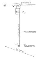
| A110-1 | IRRIGATION PUMP AND FUEL TANK 75' LEFT OF CNTRLN. RW 17 150' S. OF THR. |
| A110-2 | FOR CD CTC WICHITA APCH AT 316-350-1520. |
| A40-17/35 | NSTD LIRL RY 17/35, INCORRECT SPACING. |
| A42-35 | DSPLCD THR MKD WITH 2 LGTS EITHER SIDE WITH PAINTED TIRES. |
| A50-17 | POWER LINE APPROACH END RUNWAY 17 MARKED WITH RED BALLS |
| A57-35 | APCH RATIO 20:1 FM DSPLCD THLD. |
Runways
Runway Summary
| Runways: | 17/35 |
| Longest Runway: | 17/35 is 3230 ft (985 m) long |
| Runways with an Instrument Approach: |
49K Airport Runway Details
| Runway 17/35 | 3230 ft x 80 ft (985 m x 24 m) | |
| Surface: | Turf - Good condition - No special surface treatment | |
| Runway Edge Lights: | Non-standard lighting system Intensity | |
Runway 17 |
Runway 35 |
|
Glide Path Angle: |
0.0 degrees | 0.0 degrees |
Object at End: |
PLINE | RR |
Object Height: |
20 | 26 |
Distance from End: |
660 | 340 |
Object Centerline Offset: |
0 ft. left and right of centerline | 0 ft. left and right of centerline |
Displaced Threshold: |
180 |
Services
Airframe Repair: |
Major |
Powerplant Repair: |
Major |
Bottled Oxygen: |
Low Pressure |
Bulk Oxygen: |
None |
Fuel Available: |
100LL, Jet A |
Landing Fees: |
No |
Parking: |
Hangars and tiedowns available |
Maps & Diagrams
49K Sectional
Flight Planning
at skyvector.com
at skyvector.com