Location
Latitude: |
43-56-37.3000N (43.943694) |
Longitude: |
114-06-36.9000W (-114.11025) |
Elevation: |
6900.0 feet MSL (2103 m MSL) |
Magnetic Variation: |
12.2 E (as of April 2024 from WMM2020 model) |
Time Zone: |
UTC -7.0 (Standard Time) UTC -6.0 (Daylight Savings Time) |
From City: |
22 N.M. NE of Ketchum, Idaho |
Found On: |
Salt Lake City Chart |
FAA Region: |
ANM |
Contacts
Manager: |
Publicly owned: |
| IDAHO STATE - ITD/DIV OF AERONAUTI P.O. BOX 7129 BOISE, ID 83707-1129 208-334-8775 |
STATE OF ID, ITD DIV OF AERO P.O. BOX 7129 BOISE, ID 83707-1129 208-334-8775 |
Operations
Airport Status: |
Operational |
Facility Use: |
Public |
Type: |
Airport |
Activation Date: |
04/1956 |
Control tower: |
No |
Attendance (Months/Days/Hours): |
Months/Days/Hours Unattended |
Boundary ARTCC: |
ZLC (Salt Lake City) |
Responsible ARTCC: |
ZLC (Salt Lake City) |
Segmented Circle Indicator: |
Yes |
Traffic Pattern Altitude (MSL): |
7900 feet (2408 m) |
NOTAMs Facility: |
BOI |
NOTAM-D Service: |
Yes |
Military Landing Rights: |
No |
Civil/Military Joint Use: |
No |
Based Aircraft
Annual Operations (as of 08/30/2023)
| Total Operations: | 800 | |
| Air Taxi: | 200 | 25.0% |
| GA Itinerant: | 600 | 75.0% |
Communications
| CTAF: | 122.900 |
Fixed Based Operators (FBOs) & Fuel
(Click on a business for detail)
Please help us keep this information up to date. This is a FREE SERVICE just like everything else on Airport Guide! If you see that a business needs to be added, modified, or deleted please fill out our Update Form.
To add, modify, or delete a business click here.
Please help us keep this information up to date. This is a FREE SERVICE just like everything else on Airport Guide! If you see that a business needs to be added, modified, or deleted please fill out our Update Form.
Area Code: 208 |
| Business Name | Frequency | Phone | Fuel Grade |
|---|
Flight Service Stations
| Primary | Alternate | |
| FSS on Field: | N | |
| FSS Name (ID): | Boise(BOI) | |
| Frequency: | ||
| Toll Free Phone: | 1-800-WX-BRIEF |
Instrument Procedures / Charts
Terminal Procedures are only available for airports in several countries with more being added all the time. If you are looking for a specific country's charts, please send an email to support(at)airportguide.com stating the country name. This will be used to prioritize the implementation.
Navigation Aids (Navaids) near U61
| Dist (NM) | ID | Morse Code | Name | Type | Freq | True Hdg | Mag Hdg |
|---|---|---|---|---|---|---|---|
| 37.3 | HLE | . . . . . _ . . . | Hailey | NDB-DME | 220 | 188 | 176 |
| 64.7 | LKT | . _ . . _ . _ _ | Salmon | VOR-DME | 113.50 | 0 | 348 |
| 66.4 | HDG | . . . . _ . . _ _ . | Steelhead | NDB | 211 | 201 | 189 |
| 82.5 | DBS | _ . . _ . . . . . . | Dubois | VORTAC | 116.90 | 83 | 71 |
| 82.5 | BYI | _ . . . _ . _ _ . . | Burley | VOR-DME | 114.10 | 172 | 160 |
| 83.8 | STI | . . . _ . . | Sturgeon | NDB | 333 | 234 | 222 |
| 88.6 | TW | _ . _ _ | Strik | NDB | 389 | 187 | 175 |
| 89.4 | TWF | _ . _ _ . . _ . | Twin Falls | VORTAC | 113.10 | 190 | 178 |
| 89.9 | SWU | . . . . _ _ . . _ | Sweden | NDB | 350 | 109 | 97 |
| 90.5 | PIH | . _ _ . . . . . . . | Pocatello | VOR-DME | 112.60 | 134 | 122 |
| 91.0 | PI | . _ _ . . . | Tyhee | NDB | 383 | 129 | 117 |
| 92.3 | IDA | . . _ . . . _ | Idaho Falls | VOR-DME | 113.85 | 105 | 93 |
| 92.6 | LIA | . _ . . . . . _ | Liberator | VOR | 114.90 | 232 | 220 |
| 93.2 | BOI | _ . . . _ _ _ . . | Boise | VORTAC | 113.30 | 256 | 244 |
| 94.0 | MUO | _ _ . . _ _ _ _ | Mountain Home | TACAN | 114.00 | 235 | 223 |
| 94.3 | BOI | _ . . . _ _ _ . . | Boise | VOT | 116.70 | 256 | 243 |
| 94.6 | ID | . . _ . . | Uconn | NDB | 324 | 101 | 89 |
| 97.8 | BO | _ . . . _ _ _ | Ustik | NDB | 359 | 258 | 245 |
Nearby Airports with Fuel
Notices to Airmen (NOTAMS)
Remarks
| A110-1 | NO WINTER MAINT. |
| A110-2 | ARPT LCTD IN HIGH MTN VALLEY SURROUNDED BY HIGH MTNS. |
| A110-3 | BE ALERT ARPT SUBJECT TO ONGOING DAMAGE BY LIVESTOCK; GROUND VEHICLES AND RODENTS. |
| A110-4 | RY 18/36 -1 FT DITCH & +1 FT - 2 FT DIRT BERM ENTIRE PERIMETER OF RY. |
| A110-5 | FOR CD CTC SALT LAKE ARTCC AT 801-320-2568. |
| A110-6 | SUG: LND RWY 36 AND TKOF RWY 18 IF WX COND PERMIT. |
| A42-18 | RY 18/36 EDGES & THLDS MARKED WITH WHITE ROCKS. |
| A52-18 | ADDNL OBSTN +500 MTN 1300 FT FM THR ON CNTRLN; 14 FT ROAD 100 FT FM THR ON CNTRLN. |
| E111 | ESTABD PRIOR TO 3/31/59. |
Runways
Runway Summary
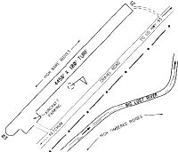
| Runways: | 18/36 |
| Longest Runway: | 18/36 is 4450 ft (1356 m) long |
| Runways with an Instrument Approach: |
U61 Airport Runway Details
| Runway 18/36 | 4450 ft x 100 ft (1356 m x 30 m) | |
| Surface: | Turf/Dirt - Fair condition - No special surface treatment | |
Runway 18 |
Runway 36 |
|
Elevation: |
6899.0 | 6900.0 |
Latitude: |
43-56-58.3500N | 43-56-16.2700N |
Longitude: |
114-06-28.1100W | 114-06-45.6500W |
|
Runway True Alignment: |
197 | 017 |
Glide Path Angle: |
0.0 degrees | 0.0 degrees |
Traffic Pattern: |
Left | Left |
Object at End: |
HILL | BERM |
Object Height: |
500 | 2 |
Distance from End: |
1300 | 0 |
Object Centerline Offset: |
0 ft. left and right of centerline | 65 ft. left and right of centerline |
Services
Airframe Repair: |
Major |
Powerplant Repair: |
Major |
Bottled Oxygen: |
High Pressure |
Bulk Oxygen: |
None |
Fuel Available: |
100LL, Jet A |
Landing Fees: |
No |
Parking: |
Tiedowns available |
Maps & Diagrams
U61 Sectional
Flight Planning
at skyvector.com
at skyvector.com