Location
Latitude: |
41-28-58.3000N (41.482861) |
Longitude: |
120-33-55.5000W (-120.565417) |
Elevation: |
4378.3 feet MSL (1335 m MSL) |
Magnetic Variation: |
13.5 E (as of April 2024 from WMM2020 model) |
Time Zone: |
UTC -8.0 (Standard Time) UTC -7.0 (Daylight Savings Time) |
From City: |
01 N.M. W of Alturas, California |
Found On: |
Klamath Falls Chart |
FAA Region: |
AWP |
Contacts
Manager: |
Publicly owned: |
| WARREN FARNAM 200 NORTH STREET ALTURAS, CA 96101 530-233-2377 |
CITY OF ALTURAS 200 NORTH STREET ALTURAS, CA 96101 530-233-2512 |
Operations
Airport Status: |
Operational |
Facility Use: |
Public |
Type: |
Airport |
Activation Date: |
10/1941 |
Control tower: |
No |
Attendance (Months/Days/Hours): |
Months/Days/Hours ALL/ALL/0800-1700 |
Boundary ARTCC: |
ZSE (Seattle) |
Responsible ARTCC: |
ZSE (Seattle) |
Lighting Schedule: |
SEE RMK |
Segmented Circle Indicator: |
Yes |
Traffic Pattern Altitude (MSL): |
5378 feet (1639 m) |
NOTAMs Facility: |
AAT |
NOTAM-D Service: |
Yes |
Based Aircraft
| Single Engine: | 8 |
| Multi Engine: | 1 |
Annual Operations (as of 12/31/2022)
| Total Operations: | 19750 | |
| Air Taxi: | 750 | 3.8% |
| GA Local: | 6000 | 30.4% |
| GA Itinerant: | 13000 | 65.8% |
Communications
| CTAF: | 122.800 |
| Unicom: | 122.800 |
| ASOS: | 124.175 (530-233-7171) |
- APCH/DEP CTL SVC PRVDD BY SEATTLE ARTCC (ZSE) ON FREQS 127.6/346.35 (KLAMATH FALLS RCAG).
Fixed Based Operators (FBOs) & Fuel
(Click on a business for detail)
Please help us keep this information up to date. This is a FREE SERVICE just like everything else on Airport Guide! If you see that a business needs to be added, modified, or deleted please fill out our Update Form.
To add, modify, or delete a business click here.
Please help us keep this information up to date. This is a FREE SERVICE just like everything else on Airport Guide! If you see that a business needs to be added, modified, or deleted please fill out our Update Form.
Area Code: 530 |
| Business Name | Frequency | Phone | Fuel Grade |
|---|---|---|---|
| Pronghorn Aviation
Update FBO info |
233-5125 | 100LL (pump), Jet A (truck) |
Flight Service Stations
| Primary | Alternate | |
| FSS on Field: | N | |
| FSS Name (ID): | Reno(RNO) | |
| Frequency: | ||
| Toll Free Phone: | 1-800-WX-BRIEF |
Instrument Procedures / Charts
FAA Terminal Procedures valid from 0901Z 03/21/24 to 0901Z 04/18/24.
There are various types of charts available for an airport. They are listed in the Page Type column. Here is a legend for those types:
APD - Airport Diagram
DP - Departure Procedure Charts
HOT - Hot Spots
IAP - Instrument Approach Procedure Charts
MIN - Minimums
STAR - Standard Terminal Arrival Charts
| Page Type | Page Name | Volume | Action Since Last Cycle |
|---|---|---|---|
| DP | CHOIR THREE (RNAV) | SW-2 | |
| IAP | RNAV (GPS) RWY 31 | SW-2 | |
| MIN | ALTERNATE MINIMUMS | SW-2 | |
| MIN | TAKEOFF MINIMUMS | SW-2 | |
| ODP | BACHS TWO (OBSTACLE) (RNAV) | SW-2 |
Terminal Procedures are only available for airports in several countries with more being added all the time. If you are looking for a specific country's charts, please send an email to support(at)airportguide.com stating the country name. This will be used to prioritize the implementation.
Navigation Aids (Navaids) near KAAT
| Dist (NM) | ID | Morse Code | Name | Type | Freq | True Hdg | Mag Hdg |
|---|---|---|---|---|---|---|---|
| 60.7 | LKV | . _ . . _ . _ . . . _ | Lakeview | VORTAC | 112.00 | 2 | 348 |
| 65.7 | LMT | . _ . . _ _ _ | Klamath Falls | VORTAC | 115.90 | 308 | 294 |
| 75.3 | AHC | . _ . . . . _ . _ . | Amedee | VOR-DME | 109.00 | 165 | 152 |
| 87.2 | MOG | _ _ _ _ _ _ _ . | Montague | NDB | 404 | 280 | 266 |
| 97.8 | RDD | . _ . _ . . _ . . | Redding | VOR-DME | 114.35 | 233 | 219 |
Nearby Airports with Fuel
| Dist (NM) | Name (Airport IDs) | True Hdg | Mag Hdg | Fuel Grade |
|---|---|---|---|---|
| 18.5 | Cedarville Airport (O59) |
76 | 63 | 100LL |
| 41.4 | Lake County Airport (LKV KLKV LKV) |
10 | 356 | 100LL, Jet A |
| 43.2 | Tulelake Municipal Airport (O81) |
304 | 290 | 100LL |
| 48.2 | Fall River Mills Airport (O89) |
234 | 220 | 100LL |
| 66.0 | Crater Lake/Klamath Regional Airport (LMT KLMT LMT) |
308 | 294 | 100LL, Jet A |
| 66.4 | Susanville Municipal Airport (SVE KSVE SVE) |
180 | 167 | 100LL, Jet A |
| 78.3 | Rogers Field Airport (O05) |
203 | 190 | 100LL, Jet A |
| 84.9 | Weed Airport (O46) |
270 | 256 | 100LL, Jet A |
| 87.2 | Siskiyou County Airport (SIY KSIY SIY) |
282 | 268 | Jet A |
| 90.0 | Montague-Yreka Rohrer Field Airport (ROF 1O5) |
280 | 266 | 100LL |
| 93.9 | Gansner Field Airport (2O1) |
190 | 177 | 100LL |
| 97.7 | Redding Regional Airport (RDD KRDD RDD) |
233 | 219 | 100LL, Jet A |
| 99.6 | Benton Field Airport (O85) |
237 | 223 | 100LL, Jet A |
Notices to Airmen (NOTAMS)
Remarks
| A11 | OPERD BY CITY OF ALTURAS. |
| A110-1 | NO TKOF RY 03 TO NE EXCP DURG ADVERSE WIND COND. 150 FT MIN ALT OVER HOUSES. |
| A110-2 | WILDLIFE REFUGES TO THE SW; SOUTH AND SE PRESENT POTENTIAL BIRD HAZARDS TO ACFT FROM OCT THRU APR. |
| A110-3 | FIRE FIGHTTING ACFT SEASONAL MAY-OCT. |
| A110-4 | ARRIVALS RY 21 DISCOURAGED DUE TO SCHOOL ON APCH. |
| A110-5 | DEER ON AND IN THE VICINITY OF ARPT. |
| A110-6 | FOR CD CTC SEATTLE ARTCC AT 253-351-3694. |
| A14 | DIR. OF PUBLIC WORKS (530) 233-2377. |
| A16 | PUBLIC WORKS IN ALTURAS. FBO AT ARPT 530-233-5125 OR 530-708-1852. |
| A35-03/21 | GROSS PAVEMENT STRENGTH PROVIDED BY AIRPORT MANAGER. |
| A57-03 | RWY 03 APCH RATIO 22:1 FM DSPLCD THLD. |
| A57-13 | RY 13 APCH RATIO 28:1 FM DSPLCD THR. |
| A57-21 | RW 21 APCH RATIO 35:1 FM DSPLCD THLD. |
| A81-APT | ACTVT REIL RWY 03 & 31; VASI RWY 03; MIRL RWY 13/31; LIRL RWY 03/21 - CTAF. |
| E111 | ESTABD PRIOR TO 15 MAY 1959. |
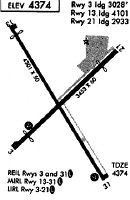
Runways
Runway Summary
| Runways: | 03/21 13/31 |
| Longest Runway: | 13/31 is 4228 ft (1289 m) long |
| Runways with an Instrument Approach: |
KAAT Airport Runway Details
| Runway 03/21 | 2506 ft x 60 ft (764 m x 18 m) | |
| Runway Length Source: | 3RD PARTY SURVEY as of 07/19/2016 | |
| Surface: | Asphalt - Good condition - No special surface treatment | |
| Runway Edge Lights: | Low Intensity | |
Runway Weight Bearing Capacity (in thousands of pounds) |
||
| Single Wheel Landing Gear: | 12.0 | |
Runway 03 |
Runway 21 |
|
Elevation: |
4365.4 | 4378.0 |
Latitude: |
41-28-50.7059N | 41-29-07.8320N |
Longitude: |
120-34-06.2332W | 120-33-42.4609W |
|
Runway True Alignment: |
046 | 226 |
Glide Path Angle: |
3.0 degrees | 0.0 degrees |
Traffic Pattern: |
Left | Right |
Runway Markings Type: |
Basic | Basic |
Runway Markings Condition: |
Fair | Fair |
Object at End: |
RR | TREE |
Object Height: |
23 | 20 |
Distance from End: |
275 | 380 |
Object Centerline Offset: |
0 ft. left and right of centerline | 0 ft. left and right of centerline |
Visual Glide Slope Indicators: |
2-Box VASI On Left Side Of Runway | |
REIL: |
Yes | No |
Touchdown Lights: |
No | No |
Centerline Lights: |
No | No |
Threshold Crossing Height: |
28 |
| Runway 13/31 | 4228 ft x 50 ft (1289 m x 15 m) | |
| Runway Length Source: | 3RD PARTY SURVEY as of 07/19/2016 | |
| Surface: | Asphalt - Good condition - No special surface treatment | |
| Runway Edge Lights: | Medium Intensity | |
Runway Weight Bearing Capacity (in thousands of pounds) |
||
| Single Wheel Landing Gear: | 12.0 | |
Runway 13 |
Runway 31 |
|
Elevation: |
4369.1 | 4378.1 |
Latitude: |
41-29-15.5129N | 41-28-39.9648N |
Longitude: |
120-34-10.8198W | 120-33-41.6744W |
|
Runway True Alignment: |
148 | 328 |
Glide Path Angle: |
0.0 degrees | 0.0 degrees |
Traffic Pattern: |
Right | |
Runway Markings Type: |
Nonprecision Instrument | Nonprecision Instrument |
Runway Markings Condition: |
Fair | Fair |
Object at End: |
ROAD | RR |
Object Height: |
16 | 15 |
Distance from End: |
300 | 250 |
Object Centerline Offset: |
0 ft. left and right of centerline | 0 ft. left and right of centerline |
REIL: |
No | Yes |
Touchdown Lights: |
No | No |
Centerline Lights: |
No | No |
Services
Airframe Repair: |
Minor |
Powerplant Repair: |
Minor |
Bottled Oxygen: |
None |
Bulk Oxygen: |
None |
Fuel Available: |
100LL, Jet A |
Landing Fees: |
No |
Parking: |
Tiedowns available |
Maps & Diagrams
KAAT Sectional
Flight Planning
at skyvector.com
at skyvector.com