Location
Latitude: |
31-50-28.1000N (31.841139) |
Longitude: |
099-24-13.0000W (-99.403611) |
Elevation: |
1696.8 feet MSL (517 m MSL) |
Magnetic Variation: |
4.2 E (as of April 2024 from WMM2020 model) |
Time Zone: |
UTC -6.0 (Standard Time) UTC -5.0 (Daylight Savings Time) |
From City: |
02 N.M. NE of Coleman, Texas |
Found On: |
San Antonio Chart |
FAA Region: |
ASW |
Contacts
Manager: |
Publicly owned: |
| RANDY LONG 503 AIRPORT LANE COLEMAN, TX 76834 325-625-5495 |
CITY OF COLEMAN 200 WEST LIVEOAK ST., PO BOX 592 COLEMAN, TX 76834 325-625-4116 |
Operations
Airport Status: |
Operational |
Facility Use: |
Public |
Type: |
Airport |
Activation Date: |
04/1942 |
Control tower: |
No |
Attendance (Months/Days/Hours): |
Months/Days/Hours ALL/MON-FRI/0800-1700 |
Boundary ARTCC: |
ZFW (Fort Worth) |
Responsible ARTCC: |
ZFW (Fort Worth) |
Lighting Schedule: |
SEE RMK |
Segmented Circle Indicator: |
Yes |
Traffic Pattern Altitude (MSL): |
2697 feet (822 m) |
NOTAMs Facility: |
FTW |
NOTAM-D Service: |
Yes |
International Airport of Entry: |
No |
Customs Landing Rights: |
No |
Military Landing Rights: |
Yes |
Civil/Military Joint Use: |
No |
Based Aircraft
| Single Engine: | 23 |
Annual Operations (as of 11/11/2023)
| Total Operations: | 7500 | |
| GA Local: | 5000 | 66.7% |
| GA Itinerant: | 2500 | 33.3% |
Communications
| CTAF: | 122.800 |
| Unicom: | 122.800 |
| AWOS-3PT: | 119.1 (325-625-3563) |
- APCH/DEP CTL SVC PRVDD BY FORT WORTH ARTCC (ZFW) ON FREQS 127.45/290.3 (ABILENE RCAG).
Fixed Based Operators (FBOs) & Fuel
(Click on a business for detail)
Please help us keep this information up to date. This is a FREE SERVICE just like everything else on Airport Guide! If you see that a business needs to be added, modified, or deleted please fill out our Update Form.
To add, modify, or delete a business click here.
Please help us keep this information up to date. This is a FREE SERVICE just like everything else on Airport Guide! If you see that a business needs to be added, modified, or deleted please fill out our Update Form.
Area Code: 915 |
| Business Name | Frequency | Phone | Fuel Grade |
|---|
Flight Service Stations
| Primary | Alternate | |
| FSS on Field: | N | |
| FSS Name (ID): | Fort Worth(FTW) | |
| Frequency: | ||
| Toll Free Phone: | 1-800-WX-BRIEF |
Instrument Procedures / Charts
FAA Terminal Procedures valid from 0901Z 03/21/24 to 0901Z 04/18/24.
There are various types of charts available for an airport. They are listed in the Page Type column. Here is a legend for those types:
APD - Airport Diagram
DP - Departure Procedure Charts
HOT - Hot Spots
IAP - Instrument Approach Procedure Charts
MIN - Minimums
STAR - Standard Terminal Arrival Charts
| Page Type | Page Name | Volume | Action Since Last Cycle |
|---|---|---|---|
| IAP | RNAV (GPS) RWY 15 | SC-3 | |
| IAP | RNAV (GPS) RWY 33 | SC-3 | |
| MIN | ALTERNATE MINIMUMS | SC-3 | |
| MIN | TAKEOFF MINIMUMS | SC-3 |
Terminal Procedures are only available for airports in several countries with more being added all the time. If you are looking for a specific country's charts, please send an email to support(at)airportguide.com stating the country name. This will be used to prioritize the implementation.
Navigation Aids (Navaids) near COM
| Dist (NM) | ID | Morse Code | Name | Type | Freq | True Hdg | Mag Hdg |
|---|---|---|---|---|---|---|---|
| 22.9 | BWD | _ . . . . _ _ _ . . | Brownwood | VOR-DME | 113.55 | 82 | 78 |
| 30.7 | UBC | . . _ _ . . . _ . _ . | Ballinger | NDB | 239 | 251 | 247 |
| 30.7 | AB | . _ _ . . . | Tomhi | NDB | 353 | 333 | 329 |
| 31.7 | TQA | _ _ _ . _ . _ | Tuscola | VOR-DME | 111.60 | 318 | 314 |
| 40.0 | BBD | _ . . . _ . . . _ . . | Brady | NDB | 380 | 174 | 170 |
| 41.6 | DYS | _ . . _ . _ _ . . . | Dyess | TACAN | 133.60 | 326 | 322 |
| 45.0 | ABI | . _ _ . . . . . | Abilene | VORTAC | 113.70 | 328 | 324 |
| 45.0 | OIP | _ _ _ . . . _ _ . | Old Rip | NDB | 410 | 41 | 37 |
| 60.6 | SJT | . . . . _ _ _ _ | San Angelo | VORTAC | 115.10 | 242 | 238 |
| 65.4 | MNZ | _ _ _ . _ _ . . | Hamilton | NDB | 251 | 101 | 97 |
| 65.5 | SWW | . . . . _ _ . _ _ | Sweetwater | NDB | 275 | 304 | 300 |
| 68.8 | SJ | . . . . _ _ _ | Woole | NDB | 356 | 240 | 236 |
| 70.2 | LLO | . _ . . . _ . . _ _ _ | Llano | VORTAC | 108.20 | 153 | 149 |
| 75.6 | AGJ | . _ _ _ . . _ _ _ | Gooch Springs | VORTAC | 112.50 | 121 | 117 |
| 77.6 | JCT | . _ _ _ _ . _ . _ | Junction | VORTAC | 116.00 | 196 | 192 |
| 80.0 | JEN | . _ _ _ . _ . | Glen Rose | TACAN | 115.00 | 75 | 71 |
| 82.6 | AKL | . _ _ . _ . _ . . | Haskell | NDB | 407 | 348 | 344 |
| 87.9 | GR | _ _ . . _ . | Starn | NDB | 323 | 116 | 112 |
| 88.9 | MQP | _ _ _ _ . _ . _ _ . | Millsap | VORTAC | 117.70 | 52 | 48 |
| 89.1 | BMQ | _ . . . _ _ _ _ . _ | Burnet | NDB | 341 | 137 | 133 |
Nearby Airports with Fuel
Notices to Airmen (NOTAMS)
Remarks
| A110-1 | N NUMBERS WILL NOT BE REPORTED |
| A110-2 | FOR CD CTC FORT WORTH ARTCC AT 817-858-7584. |
| A17 | EMPLOYEE LIVES ON PREMISES. |
| A33-15/33 | NMRS CRACKS AND PAVEMENT SPALLING. |
| A81-APT | RY 15/33 MIRL PRESET TO LOW; TO INCR INTST AND ACTVT - CTAF. |
Runways
Runway Summary
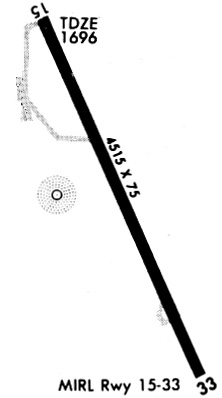
| Runways: | 15/33 |
| Longest Runway: | 15/33 is 4506 ft (1373 m) long |
| Runways with an Instrument Approach: |
COM Airport Runway Details
| Runway 15/33 | 4506 ft x 75 ft (1373 m x 23 m) | |
| Runway Length Source: | 3RD PARTY SURVEY as of 08/11/2011 | |
| Surface: | Asphalt - Poor condition - No special surface treatment | |
| Runway Edge Lights: | Medium Intensity | |
Runway Weight Bearing Capacity (in thousands of pounds) |
||
| Single Wheel Landing Gear: | 12.5 | |
Runway 15 |
Runway 33 |
|
Elevation: |
1696.8 | 1679.2 |
Latitude: |
31-50-48.3459N | 31-50-07.8893N |
Longitude: |
099-24-23.9754W | 099-24-02.0254W |
|
Runway True Alignment: |
155 | 335 |
Glide Path Angle: |
0.0 degrees | 0.0 degrees |
Traffic Pattern: |
Left | Left |
Runway Markings Type: |
Nonprecision Instrument | Nonprecision Instrument |
Runway Markings Condition: |
Fair | Fair |
Object at End: |
ROAD | TREES |
Object Height: |
10 | 21 |
Distance from End: |
674 | 812 |
Object Centerline Offset: |
0 ft. left and right of centerline | 71 ft. left of centerline |
Services
Airframe Repair: |
None |
Powerplant Repair: |
None |
Bottled Oxygen: |
None |
Bulk Oxygen: |
None |
Fuel Available: |
100LL |
Landing Fees: |
No |
Parking: |
Tiedowns available |
Maps & Diagrams
COM Sectional
Flight Planning
at skyvector.com
at skyvector.com