Location
Latitude: |
34-39-56.2300N (34.665619) |
Longitude: |
120-28-03.0100W (-120.467503) |
Elevation: |
88.1 feet MSL (27 m MSL) |
Magnetic Variation: |
12.1 E (as of April 2024 from WMM2020 model) |
Time Zone: |
UTC -8.0 (Standard Time) UTC -7.0 (Daylight Savings Time) |
From City: |
02 N.M. N of Lompoc, California |
Found On: |
Los Angeles Chart |
FAA Region: |
AWP |
Contacts
Manager: |
Publicly owned: |
| RICHARD FERNBAUGH CITY OF LOMPOC, 100 CIVIC CENTER PLAZA LOMPOC, CA 93436-8001 805-875-8268 |
CITY OF LOMPOC 100 CIVIC CENTER PLAZA LOMPOC, CA 93436-8001 805-875-8268 |
Operations
Airport Status: |
Operational |
Facility Use: |
Public |
Type: |
Airport |
Activation Date: |
03/1962 |
Control tower: |
No |
Attendance (Months/Days/Hours): |
Months/Days/Hours ALL/ALL/0800-1700 |
Boundary ARTCC: |
ZLA (Los Angeles) |
Responsible ARTCC: |
ZLA (Los Angeles) |
Lighting Schedule: |
SEE RMK |
Segmented Circle Indicator: |
Yes |
Traffic Pattern Altitude (MSL): |
1088 feet (332 m) |
NOTAMs Facility: |
LPC |
NOTAM-D Service: |
Yes |
International Airport of Entry: |
No |
Customs Landing Rights: |
No |
Military Landing Rights: |
Yes |
Civil/Military Joint Use: |
No |
Based Aircraft
| Single Engine: | 41 |
| Multi Engine: | 1 |
Annual Operations (as of 10/16/2023)
| Total Operations: | 30000 | |
| GA Local: | 15000 | 50.0% |
| GA Itinerant: | 15000 | 50.0% |
Communications
| CTAF: | 122.700 |
| Unicom: | 122.700 |
| Approach: | SANTA BARBARA 124.15 124.15 L.A. CENTER ARTCC |
| Departure: | SANTA BARBARA 124.15 124.15 L.A. CENTER ARTCC |
| AWOS-3PT: | 133.875 (805-735-3075) |
- APCH/DEP CTL SVC PRVDD BY LOS ANGELES ARTCC (ZLA) ON FREQS 119.05/269.5 (SAN LUIS OBISPO RCAG) WHEN SANTA BARBARA APCH CTL (SBA) CLSD.
Fixed Based Operators (FBOs) & Fuel
(Click on a business for detail)
Please help us keep this information up to date. This is a FREE SERVICE just like everything else on Airport Guide! If you see that a business needs to be added, modified, or deleted please fill out our Update Form.
To add, modify, or delete a business click here.
Please help us keep this information up to date. This is a FREE SERVICE just like everything else on Airport Guide! If you see that a business needs to be added, modified, or deleted please fill out our Update Form.
Area Code: 805 |
| Business Name | Frequency | Phone | Fuel Grade |
|---|---|---|---|
| Airport Management
Update FBO info |
Unicom 122.7 | 736-4085 | 100LL |
Flight Service Stations
| Primary | Alternate | |
| FSS on Field: | N | |
| FSS Name (ID): | Hawthorne(HHR) | |
| Frequency: | ||
| Toll Free Phone: | 1-800-WX-BRIEF |
Instrument Procedures / Charts
FAA Terminal Procedures valid from 0901Z 03/21/24 to 0901Z 04/18/24.
There are various types of charts available for an airport. They are listed in the Page Type column. Here is a legend for those types:
APD - Airport Diagram
DP - Departure Procedure Charts
HOT - Hot Spots
IAP - Instrument Approach Procedure Charts
MIN - Minimums
STAR - Standard Terminal Arrival Charts
| Page Type | Page Name | Volume | Action Since Last Cycle |
|---|---|---|---|
| IAP | RNAV (GPS) RWY 25 | SW-3 | |
| IAP | VOR/DME-A | SW-3 | Changed |
| MIN | ALTERNATE MINIMUMS | SW-3 | |
| MIN | TAKEOFF MINIMUMS | SW-3 |
Terminal Procedures are only available for airports in several countries with more being added all the time. If you are looking for a specific country's charts, please send an email to support(at)airportguide.com stating the country name. This will be used to prioritize the implementation.
Navigation Aids (Navaids) near LPC
| Dist (NM) | ID | Morse Code | Name | Type | Freq | True Hdg | Mag Hdg |
|---|---|---|---|---|---|---|---|
| 7.0 | VBG | . . . _ _ . . . _ _ . | Vandenberg | TACAN | 112.25 | 305 | 293 |
| 17.4 | GLJ | _ _ . . _ . . . _ _ _ | Guadalupe | VOR | 113.05 | 351 | 339 |
| 20.3 | GVO | _ _ . . . . _ _ _ _ | Gaviota | VORTAC | 113.80 | 113 | 101 |
| 35.7 | RZS | . _ . _ _ . . . . . | San Marcus | VORTAC | 114.90 | 105 | 93 |
| 38.0 | MQO | _ _ _ _ . _ _ _ _ | Morro Bay | VORTAC | 112.40 | 337 | 325 |
| 39.2 | FLW | . . _ . . _ . . . _ _ | Fellows | VOR-DME | 117.50 | 48 | 36 |
| 60.9 | PRB | . _ _ . . _ . _ . . . | Paso Robles | VORTAC | 114.30 | 352 | 340 |
| 63.6 | AVE | . _ . . . _ . | Avenal | VOR-DME | 117.10 | 22 | 10 |
| 73.2 | CMA | _ . _ . _ _ . _ | Camarillo | VOR-DME | 115.80 | 111 | 99 |
| 74.1 | NTD | _ . _ _ . . | Point Mugu | TACAN | 110.60 | 115 | 103 |
| 77.6 | VTU | . . . _ _ . . _ | Ventura | VOR-DME | 108.20 | 114 | 102 |
| 79.6 | GMN | _ _ . _ _ _ . | Gorman | VORTAC | 116.10 | 83 | 71 |
| 80.6 | FIM | . . _ . . . _ _ | Fillmore | VORTAC | 112.50 | 102 | 90 |
| 83.3 | EHF | . . . . . . . _ . | Shafter | VORTAC | 115.40 | 53 | 41 |
| 83.3 | BFL | _ . . . . . _ . . _ . . | Bakersfield | VOT | 111.20 | 56 | 44 |
| 85.4 | HGT | . . . . _ _ . _ | Hunter Liggett | NDB | 209 | 335 | 323 |
| 89.0 | ROM | . _ . _ _ _ _ _ | Priest | VOR | 110.00 | 353 | 341 |
| 93.3 | LHS | . _ . . . . . . . . . | Lake Hughes | VORTAC | 114.35 | 88 | 76 |
| 95.7 | COR | _ . _ . _ _ _ . _ . | Salyer Farms | NDB | 205 | 28 | 16 |
| 99.4 | NSI | _ . . . . . . | San Nicolas | TACAN | 110.20 | 149 | 137 |
Nearby Airports with Fuel
Notices to Airmen (NOTAMS)
Remarks
| A110-1 | DEER ON & INVOF ARPT. |
| A110-2 | ULTRALIGHT, AND SKY DIVING ACTIVITY INVOF OF ARPT DALGT HRS FRI-SUN. |
| A110-3 | FOR CD CTC LOS ANGELES ARTCC AT 661-575-2079. |
| A110-4 | TWY LGTS OTS UFN. |
| A17 | ATNDD BY FBO, PHONE 805-717-3558. |
| A70-FUEL-10 | 0LL FUEL AVBL 24 HRS; SELF-SERVICE CREDIT CARD ONLY. |
| A81-APT | ACTVT REIL RWY 25; MIRL RWY 07/25 - CTAF. PAPI RWY 25 ON CONSLY. |
Runways
Runway Summary
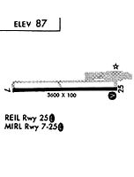
| Runways: | 07/25 |
| Longest Runway: | 07/25 is 4600 ft (1402 m) long |
| Runways with an Instrument Approach: |
LPC Airport Runway Details
| Runway 07/25 | 4600 ft x 100 ft (1402 m x 30 m) | |
| Runway Length Source: | ADO as of 06/03/2003 | |
| Surface: | Asphalt - Excellent condition - No special surface treatment | |
| Runway Edge Lights: | Medium Intensity | |
Runway Weight Bearing Capacity (in thousands of pounds) |
||
| Single Wheel Landing Gear: | 17.0 | |
Runway 07 |
Runway 25 |
|
Elevation: |
79.0 | 88.1 |
Latitude: |
34-39-56.6100N | 34-39-55.8500N |
Longitude: |
120-28-30.5400W | 120-27-35.4800W |
|
Runway True Alignment: |
091 | 271 |
Glide Path Angle: |
0.0 degrees | 3.2 degrees |
Traffic Pattern: |
Left | Right |
Runway Markings Type: |
Nonprecision Instrument | Nonprecision Instrument |
Runway Markings Condition: |
Good | Good |
Object at End: |
BRUSH | PLINE |
Object Height: |
25 | 25 |
Object Marked/Lighted?: |
Marked | |
Distance from End: |
720 | 1050 |
Object Centerline Offset: |
0 ft. left and right of centerline | 0 ft. left and right of centerline |
Visual Glide Slope Indicators: |
4-Light PAPI On Left Side Of Runway | |
REIL: |
No | Yes |
Touchdown Lights: |
No | No |
Centerline Lights: |
No | No |
Threshold Crossing Height: |
25 | |
Threshold Elevation: |
87.7 | |
Displaced Threshold: |
118 | |
Threshold Latitude: |
34-39-55.8700N | |
Threshold Longitude: |
120-27-36.8900W |
Services
Airframe Repair: |
None |
Powerplant Repair: |
None |
Bottled Oxygen: |
None |
Bulk Oxygen: |
None |
Fuel Available: |
100LL |
Landing Fees: |
No |
Parking: |
Tiedowns available |
Maps & Diagrams
LPC Sectional
Flight Planning
at skyvector.com
at skyvector.com