Location
Latitude: |
33-56-55.1050N (33.94864) |
Longitude: |
083-19-33.2910W (-83.325914) |
Elevation: |
812.2 feet MSL (248 m MSL) |
Magnetic Variation: |
6.2 W (as of May 2024 from WMM2020 model) |
Time Zone: |
UTC -5.0 (Standard Time) UTC -4.0 (Daylight Savings Time) |
From City: |
03 N.M. E of Athens, Georgia |
Found On: |
Atlanta Chart |
FAA Region: |
ASO |
Contacts
Manager: |
Publicly owned: |
| MIKE MATTHEWS 1010 BEN EPPS DRIVE ATHENS, GA 30605 706-613-3416 |
CLARKE COUNTY PO BOX 448, CO COURTHOUSE ATHENS, GA 30601 706-613-3420 |
Operations
Airport Status: |
Operational |
Facility Use: |
Public |
Type: |
Airport |
Activation Date: |
07/1940 |
Control tower: |
Yes |
Attendance (Months/Days/Hours): |
Months/Days/Hours ALL/ALL/0600-2100 |
Boundary ARTCC: |
ZTL (Atlanta) |
Responsible ARTCC: |
ZTL (Atlanta) |
Lighting Schedule: |
SEE RMK |
Segmented Circle Indicator: |
Yes |
Traffic Pattern Altitude (MSL): |
1812 feet (552 m) |
NOTAMs Facility: |
AHN |
NOTAM-D Service: |
Yes |
International Airport of Entry: |
No |
Customs Landing Rights: |
No |
Military Landing Rights: |
Yes |
Civil/Military Joint Use: |
No |
Aircraft Rescue and Firefighting: |
Class IV ARFF Index: A Air Carrier Service: Not Scheduled Certification Date: 02/1985 |
Based Aircraft
| Single Engine: | 68 |
| Multi Engine: | 7 |
| Jet Engine: | 3 |
| GA Helicopters: | 1 |
| Gliders: | 1 |
Annual Operations (as of 04/30/2023)
| Total Operations: | 39471 | |
| Commercial: | 50 | 0.1% |
| Air Taxi: | 2444 | 6.2% |
| GA Local: | 15595 | 39.5% |
| GA Itinerant: | 20634 | 52.3% |
| Military Aircraft: | 748 | 1.9% |
Communications
| CTAF: | 126.300 |
| Unicom: | 122.950 |
| Tower: | ATHENS 126.3 338.275 Hrs: 0800-2000 |
| Clearance Del.: | 121.8 |
| Ground: | 121.8 |
| Approach: | ATLANTA 132.475 ;0615-2200 132.475 ;0615-2200 ATLANTA ARTCC |
| Departure: | ATLANTA 132.475 ;0615-2200 132.475 ;0615-2200 ATLANTA ARTCC |
| ASOS: | 132.875 (706-613-7373) |
- APCH/DEP SVC AND CLNC DEL PRVDD BY ATLANTA TRACON (A80) ON FREQS 132.475/291.1 0615-2200; APCH/DEP SVC PRVDD BY ATLANTA ARTCC (ZTL) ON FREQS 134.8/379.95, 2200-0615 (FOOTHILLS RCAG).
Fixed Based Operators (FBOs) & Fuel
(Click on a business for detail)
Please help us keep this information up to date. This is a FREE SERVICE just like everything else on Airport Guide! If you see that a business needs to be added, modified, or deleted please fill out our Update Form.
To add, modify, or delete a business click here.
Please help us keep this information up to date. This is a FREE SERVICE just like everything else on Airport Guide! If you see that a business needs to be added, modified, or deleted please fill out our Update Form.
Area Code: 706 |
| Business Name | Frequency | Phone | Fuel Grade |
|---|---|---|---|
| Athens-Ben Epps Airport
Update FBO info |
Unicom 122.95 | 613-3420 | 100LL, Jet A |
| Clark Flying Service
Update FBO info |
353-3213 | ||
| Colvin Aviation, Inc.
Update FBO info |
769-8180, 548-0717 | ||
| Georgia Flight
Update FBO info |
543-4359 | ||
| Sonny's Air Service
Update FBO info |
549-9294 |
Flight Service Stations
| Primary | Alternate | |
| FSS on Field: | N | |
| FSS Name (ID): | Macon(MCN) | |
| Frequency: | ||
| Toll Free Phone: | 1-800-WX-BRIEF |
Instrument Procedures / Charts
FAA Terminal Procedures valid from 0901Z 03/21/24 to 0901Z 04/18/24.
There are various types of charts available for an airport. They are listed in the Page Type column. Here is a legend for those types:
APD - Airport Diagram
DP - Departure Procedure Charts
HOT - Hot Spots
IAP - Instrument Approach Procedure Charts
MIN - Minimums
STAR - Standard Terminal Arrival Charts
| Page Type | Page Name | Volume | Action Since Last Cycle |
|---|---|---|---|
| APD | AIRPORT DIAGRAM | SE-4 | |
| IAP | ILS OR LOC/DME RWY 27 | SE-4 | |
| IAP | RNAV (GPS) RWY 02 | SE-4 | |
| IAP | RNAV (GPS) RWY 09 | SE-4 | |
| IAP | RNAV (GPS) RWY 20 | SE-4 | |
| IAP | RNAV (GPS) RWY 27 | SE-4 | |
| IAP | VOR RWY 02 | SE-4 | |
| MIN | ALTERNATE MINIMUMS | SE-4 | |
| MIN | TAKEOFF MINIMUMS | SE-4 |
Terminal Procedures are only available for airports in several countries with more being added all the time. If you are looking for a specific country's charts, please send an email to support(at)airportguide.com stating the country name. This will be used to prioritize the implementation.
Navigation Aids (Navaids) near AHN
| Dist (NM) | ID | Morse Code | Name | Type | Freq | True Hdg | Mag Hdg |
|---|---|---|---|---|---|---|---|
| 0.1 | AHN | . _ . . . . _ . | Athens | VOR-DME | 116.95 | 138 | 144 |
| 5.3 | BJT | _ . . . . _ _ _ _ | Bulldog | NDB | 221 | 88 | 94 |
| 11.9 | DDA | _ . . _ . . . _ | Commerce | NDB | 244 | 305 | 311 |
| 13.1 | BMW | _ . . . _ _ . _ _ | Barrow County | NDB | 404 | 266 | 272 |
| 23.6 | VV | . . . _ . . . _ | Junne | NDB | 353 | 140 | 146 |
| 23.7 | JNM | . _ _ _ _ . _ _ | Monroe | NDB | 392 | 237 | 243 |
| 27.1 | TX | _ _ . . _ | Gwnet | NDB | 419 | 279 | 285 |
| 27.6 | IIY | . . . . _ . _ _ | Washington/Wilkes County | NDB | 435 | 112 | 118 |
| 29.7 | VOF | . . . _ _ _ _ . . _ . | Alcovy | NDB | 370 | 230 | 236 |
| 32.6 | FKV | . . _ . _ . _ . . . _ | Flowery Branch | NDB | 365 | 298 | 304 |
| 35.0 | AJR | . _ . _ _ _ . _ . | Habersham | NDB | 347 | 341 | 347 |
| 39.0 | ELW | . . _ . . . _ _ | Electric City | VORTAC | 108.60 | 43 | 49 |
| 43.4 | AA | . _ . _ | Cedar | NDB | 341 | 124 | 130 |
| 44.9 | ODF | _ _ _ _ . . . . _ . | Foothills | VOR-DME | 113.40 | 1 | 7 |
| 48.5 | UMB | . . _ _ _ _ . . . | Culvr | NDB | 380 | 170 | 176 |
| 48.6 | PDK | . _ _ . _ . . _ . _ | Peachtree | VOR-DME | 116.60 | 265 | 271 |
| 48.6 | CEU | _ . _ . . . . _ | Clemson | NDB | 257 | 26 | 32 |
| 52.4 | BR | _ . . . . _ . | Redan | NDB | 266 | 249 | 255 |
| 57.4 | GSU | _ _ . . . . . . _ | Atlanta | DME | 116.9 | 251 | 257 |
| 57.5 | ATL | . _ _ . _ . . | Atlanta Muni | VOT | 111.00 | 252 | 258 |
Nearby Airports with Fuel
Notices to Airmen (NOTAMS)
Remarks
| A110-3 | NOISE SENSITIVE AREA S OF ARPT; CTC FBO FOR INFORMATION. |
| A110-6 | CLSD TO UNSKED ACR OPNS WITH MORE THAN 30 PSGR SEATS EXCP 24 HRS PPR CALL AMGR 706-613-3420. |
| A110-7 | FOR CD IF UNA TO CTC ON FSS FREQ, CTC ATLANTA APCH AT 678-364-6131, WHEN ATCT CLSD CTC ATLANTA ARTCC AT 770-210-7692. |
| A26 | INDEX B ARFF EQPT IS AVBL. |
| A30-02/20 | RWY 2/20 NOT AVBL FOR SKED ACR OPNS WITH MORE THAN 9 PSGR SEATS OR UNSKED ACR AT LEAST 31 PSGR SEATS. |
| A81-APT | ACTVT MALSF RWY 27; PAPI RWY 09 & 20 - CTAF. WHEN ATCT CLSD HIRL RWY 09/27 PRESET LOW INTST; TO INCR INTST ACTVT - CTAF. RWY 2 & 20 LGTS NOT AVBL WHEN ATCT IS CLSD. |
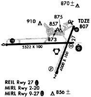
Runways
Runway Summary
| Runways: | 02/20 09/27 |
| Longest Runway: | 09/27 is 6122 ft (1866 m) long |
| Runways with an Instrument Approach: | 27 |
AHN Airport Runway Details
| Runway 02/20 | 3995 ft x 100 ft (1218 m x 30 m) | |
| Runway Length Source: | 3RD PARTY SURVEY as of 03/07/2010 | |
| Surface: | Asphalt - Excellent condition - No special surface treatment | |
| Runway Pavement Class: | 7 /F/B/X/T | |
| Runway Edge Lights: | Medium Intensity | |
Runway Weight Bearing Capacity (in thousands of pounds) |
||
| Single Wheel Landing Gear: | 40.0 | |
| Dual Wheel Landing Gear: | 45.0 | |
Runway 02 |
Runway 20 |
|
Elevation: |
774.6 | 803.3 |
Latitude: |
33-56-33.7767N | 33-57-10.7230N |
Longitude: |
083-19-29.5303W | 083-19-12.6984W |
|
Runway True Alignment: |
021 | 201 |
Glide Path Angle: |
3.8 degrees | 3.0 degrees |
Traffic Pattern: |
Left | Left |
Runway Markings Type: |
Nonprecision Instrument | Nonprecision Instrument |
Runway Markings Condition: |
Good | Good |
Object at End: |
TREES | TREES |
Object Height: |
72 | 63 |
Distance from End: |
1500 | 1475 |
Object Centerline Offset: |
150 ft. left of centerline | 250 ft. right of centerline |
Visual Glide Slope Indicators: |
4-Box VASI On Left Side Of Runway | 4-Light PAPI On Left Side Of Runway |
Threshold Crossing Height: |
39 | 55 |
| Runway 09/27 | 6122 ft x 100 ft (1866 m x 30 m) | |
| Runway Length Source: | 3RD PARTY SURVEY as of 02/02/2021 | |
| Surface: | Asphalt - Excellent condition - Saw-cut or plastic grooved | |
| Runway Pavement Class: | 47 /F/B/X/T | |
| Runway Edge Lights: | High Intensity | |
Runway Weight Bearing Capacity (in thousands of pounds) |
||
| Single Wheel Landing Gear: | 65.0 | |
| Dual Wheel Landing Gear: | 125.0 | |
Runway 09 |
Runway 27 |
|
Elevation: |
755.5 | 811.9 |
Latitude: |
33-56-56.0782N | 33-56-57.8536N |
Longitude: |
083-20-17.5537W | 083-19-04.9208W |
|
Runway True Alignment: |
088 | 268 |
ILS Type: |
LOC/GS | |
Glide Path Angle: |
3.0 degrees | 3.0 degrees |
Traffic Pattern: |
Left | Left |
Runway Markings Type: |
Nonprecision Instrument | Precision Instrument |
Runway Markings Condition: |
Good | Good |
Object Centerline Offset: |
150 ft. left of centerline | 250 ft. right of centerline |
Visual Glide Slope Indicators: |
4-Light PAPI On Left Side Of Runway | 4-Light PAPI On Left Side Of Runway |
Approach Light System: |
1,400 Foot Medium Intensity Approach Lighting System With Sequenced Flashers | |
REIL: |
No | |
Threshold Crossing Height: |
39 | 44 |
Services
Airframe Repair: |
Major |
Powerplant Repair: |
Major |
Bottled Oxygen: |
None |
Bulk Oxygen: |
None |
Fuel Available: |
100LL, Jet A+ |
Parking: |
Tiedowns available |
Maps & Diagrams
AHN Sectional
Flight Planning
at skyvector.com
at skyvector.com