Location
Latitude: |
45-41-42.3430N (45.695095) |
Longitude: |
118-50-36.1270W (-118.843369) |
Elevation: |
1494.2 feet MSL (455 m MSL) |
Magnetic Variation: |
14 E (as of April 2024 from WMM2020 model) |
Time Zone: |
UTC -8.0 (Standard Time) UTC -7.0 (Daylight Savings Time) |
From City: |
03 N.M. NW of Pendleton, Oregon |
Found On: |
Seattle Chart |
FAA Region: |
ANM |
Contacts
Manager: |
Publicly owned: |
| STEVE CHRISMAN 2016 AIRPORT ROAD PENDLETON, OR 97801 541-276-7754 |
CITY OF PENDLETON 2016 AIRPORT ROAD PENDLETON, OR 97801 541-276-7754 |
Operations
Airport Status: |
Operational |
Facility Use: |
Public |
Type: |
Airport |
Activation Date: |
10/1937 |
Control tower: |
Yes |
Attendance (Months/Days/Hours): |
Months/Days/Hours ALL/ALL/0600-2000 |
Boundary ARTCC: |
ZSE (Seattle) |
Responsible ARTCC: |
ZSE (Seattle) |
Lighting Schedule: |
SEE RMK |
Segmented Circle Indicator: |
Yes |
Traffic Pattern Altitude (MSL): |
2494 feet (760 m) |
NOTAMs Facility: |
PDT |
NOTAM-D Service: |
Yes |
International Airport of Entry: |
No |
Customs Landing Rights: |
No |
Military Landing Rights: |
Yes |
Civil/Military Joint Use: |
No |
Based Aircraft
| Single Engine: | 47 |
| Multi Engine: | 2 |
| GA Helicopters: | 25 |
| Military Aircraft: | 7 |
Annual Operations (as of 12/31/2018)
| Total Operations: | 14881 | |
| Air Taxi: | 4171 | 28.0% |
| GA Local: | 4041 | 27.2% |
| GA Itinerant: | 4888 | 32.8% |
| Military Aircraft: | 1781 | 12.0% |
Communications
| CTAF: | 119.700 |
| Unicom: | 122.950 |
| Tower: | PENDLETON 119.7 257.8 Hrs: 0600-2000 |
| Ground: | 121.9 257.8 |
| Approach: | SPOKANE 133.15 133.15 SEATTLE ARTCC |
| Departure: | SPOKANE 133.15 133.15 SEATTLE ARTCC |
| ASOS: | 118.325 (541-278-2329) |
| ANG OPS: | 142.8 |
| ANG OPS: | 248.5 |
| ANG OPS: | 40.9 |
- APCH/DEP CTL SVC PROVDD BY SEATTLE ARTCC (ZSE) ON 132.6/269.35 (YAKIMA RCAG), WHEN GEG APCH CLSD.
- ATCT OPERATED BY BARTON ATC INC.
Fixed Based Operators (FBOs) & Fuel
(Click on a business for detail)
Please help us keep this information up to date. This is a FREE SERVICE just like everything else on Airport Guide! If you see that a business needs to be added, modified, or deleted please fill out our Update Form.
To add, modify, or delete a business click here.
Please help us keep this information up to date. This is a FREE SERVICE just like everything else on Airport Guide! If you see that a business needs to be added, modified, or deleted please fill out our Update Form.
Area Code: 541 |
| Business Name | Frequency | Phone | Fuel Grade |
|---|---|---|---|
| General Aircraft Services
Update FBO info |
Unicom 122.95 | 276-3554 | |
| Pendleton Aircraft Services
Update FBO info |
276-1441 | ||
| Pendleton Aviation
Update FBO info |
Unicom 122.95 | 276-3313 | 100LL, Jet A |
Flight Service Stations
| Primary | Alternate | |
| FSS on Field: | N | |
| FSS Name (ID): | Mc Minnville(MMV) | |
| Frequency: | ||
| Toll Free Phone: | 1-800-WX-BRIEF |
Instrument Procedures / Charts
FAA Terminal Procedures valid from 0901Z 03/21/24 to 0901Z 04/18/24.
There are various types of charts available for an airport. They are listed in the Page Type column. Here is a legend for those types:
APD - Airport Diagram
DP - Departure Procedure Charts
HOT - Hot Spots
IAP - Instrument Approach Procedure Charts
MIN - Minimums
STAR - Standard Terminal Arrival Charts
| Page Type | Page Name | Volume | Action Since Last Cycle |
|---|---|---|---|
| APD | AIRPORT DIAGRAM | NW-1 | |
| HOT | HOT SPOT | NW-1 | |
| IAP | ILS OR LOC RWY 26 | NW-1 | |
| IAP | RNAV (GPS) RWY 08 | NW-1 | |
| IAP | RNAV (GPS) RWY 11 | NW-1 | |
| IAP | RNAV (GPS) RWY 26 | NW-1 | |
| IAP | RNAV (GPS) RWY 29 | NW-1 | |
| IAP | VOR RWY 08 | NW-1 | |
| MIN | ALTERNATE MINIMUMS | NW-1 | |
| MIN | TAKEOFF MINIMUMS | NW-1 |
Terminal Procedures are only available for airports in several countries with more being added all the time. If you are looking for a specific country's charts, please send an email to support(at)airportguide.com stating the country name. This will be used to prioritize the implementation.
Navigation Aids (Navaids) near PDT
| Dist (NM) | ID | Morse Code | Name | Type | Freq | True Hdg | Mag Hdg |
|---|---|---|---|---|---|---|---|
| 4.0 | PDT | . _ _ . _ . . _ | Pendleton | VORTAC | 114.70 | 272 | 258 |
| 4.7 | PD | . _ _ . _ . . | Foris | NDB | 230 | 89 | 75 |
| 32.9 | ALW | . _ . _ . . . _ _ | Walla Walla | VOR-DME | 116.40 | 44 | 30 |
| 36.4 | PSC | . _ _ . . . . _ . _ . | Pasco | VOR-DME | 113.75 | 341 | 327 |
| 39.5 | AL | . _ . _ . . | Trina | NDB | 353 | 42 | 28 |
| 42.6 | LGD | . _ . . _ _ . _ . . | La Grande | NDB | 296 | 119 | 105 |
| 67.4 | BKE | _ . . . _ . _ . | Baker City | VOR-DME | 115.30 | 139 | 125 |
| 72.8 | IMB | . . _ _ _ . . . | Kimberly | VOR-DME | 115.60 | 210 | 196 |
| 80.8 | YK | _ . _ _ _ . _ | Donny | NDB | 371 | 308 | 294 |
| 84.8 | YKM | _ . _ _ _ . _ _ _ | Yakima | VORTAC | 116.00 | 308 | 294 |
| 87.1 | MW | _ _ . _ _ | Pelly | NDB | 408 | 348 | 334 |
| 89.3 | PUW | . _ _ . . . _ . _ _ | Pullman | VOR-DME | 117.15 | 48 | 34 |
| 92.0 | MQG | _ _ _ _ . _ _ _ . | Nez Perce | VOR-DME | 114.45 | 62 | 48 |
| 93.0 | MWH | _ _ . _ _ . . . . | Moses Lake | VOR-DME | 115.00 | 348 | 334 |
| 94.6 | LTJ | . _ . . _ . _ _ _ | Klickitat | VOR-DME | 112.30 | 271 | 257 |
Nearby Airports with Fuel
Notices to Airmen (NOTAMS)
Remarks
| A110-2 | INT OF RAMP & RWY 29 NORTH END OF TRML BLDG; AREA OBSTD FROM VIEW OF TWR BY TRML BLDG. |
| A110-4 | TWY B CLSD SOUTH OF TWY A. |
| A110-5 | DEER ON & INVOF ARPT APR AND AUG, ESPECIALLY MORNINGS AND EVENINGS. |
| A110-7 | WHEN APCH CLSD, FOR CD CTC SEATTLE ARTCC AT 253-351-3694 |
| A110-8 | FQT DLY UAS ACTVTY (LGE & SMALL) INSIDE & INVOF THE CDAS. |
| A16 | 541-966-0243 (ENGINEERING) - WAYNE GREEN |
| A17 | SVCS AVBL FM FBO BTN 2000-0600 BY FONE CALL 541-276-3313/PENDLETON AVN OR 541-310-9542/WILDHORSE HEL. SELF FUELING CARDLOCKS AVBL 24 HRS. |
| A26 | CLSD TO UNSKED ACR OPN WITH MORE THAN 30 PSGR SEATS EXCP PPR 4 HRS CALL 541-276-4411. |
| A30-11/29 | THLD 29 NSTD MRK - PORTION OF RY TO FUNCTION AS TWY. |
| A33-08/26 | SURFACE CONDITION UNMONITORED 1400-0400Z. |
| A33-11/29 | SURFACE CONDITION UNMONITORED 1400-0400Z. |
| A48-11 | RWY END 11 OUT OF SERVICE. |
| A48-29 | RWY END 29 OUT OF SERVICE. |
| A81-APT | WHEN ATCT CLSD ACTVT MALSR RWY 26; ODALS RWY 08; REIL RWY 11 & 29; VASI RWY 08, PAPI RWY 11; HIRL RWY 08/26; MIRL RWY 11/29 - CTAF. RWY 11/29 PCL FOR HI INTST 5 CLICKS ONLY. PAPI RWY 29 OPR CONSLY. |
| E111 | ESTABD PRIOR TO 1959 /1934/. |
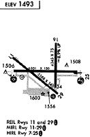
Runways
Runway Summary
| Runways: | 08/26 11/29 |
| Longest Runway: | 08/26 is 6301 ft (1921 m) long |
| Runways with an Instrument Approach: | 26 |
PDT Airport Runway Details
| Runway 08/26 | 6301 ft x 150 ft (1921 m x 46 m) | |
| Runway Length Source: | 3RD PARTY SURVEY as of 03/31/2022 | |
| Surface: | Asphalt - Fair condition - Porous friction course | |
| Runway Pavement Class: | 34 /F/B/Y/U | |
| Runway Edge Lights: | High Intensity | |
Runway Weight Bearing Capacity (in thousands of pounds) |
||
| Single Wheel Landing Gear: | 115.0 | |
| Dual Wheel Landing Gear: | 132.0 | |
| Dual Tandem Wheel Landing Gear: | 210.0 | |
Runway 08 |
Runway 26 |
|
Elevation: |
1486.3 | 1486.6 |
Latitude: |
45-41-43.2177N | 45-41-43.3762N |
Longitude: |
118-51-12.1370W | 118-49-43.3773W |
|
Runway True Alignment: |
090 | 270 |
ILS Type: |
ILS | |
Glide Path Angle: |
3.0 degrees | 3.0 degrees |
Traffic Pattern: |
Left | Left |
Runway Markings Type: |
Nonprecision Instrument | Precision Instrument |
Runway Markings Condition: |
Good | Good |
Object at End: |
GND | |
Object Height: |
8 | |
Distance from End: |
200 | |
Object Centerline Offset: |
500 ft. right of centerline | |
Visual Glide Slope Indicators: |
4-Box VASI On Right Side Of Runway | 4-Light PAPI On Left Side Of Runway |
Runway Visual Range (RVR): |
Rollout | Touchdown |
Approach Light System: |
Omnidirectional Approach Lighting System | 1,400 Foot Medium Intensity Approach Lighting System With Runway Alignment Indicator Lights |
Threshold Crossing Height: |
35 | 48 |
Declared Distances |
||
Take Off Run Avbl. (TORA): |
6301 | 6301 |
Take Off Distance Avbl. (TODA): |
6301 | 6301 |
Actual Stop Dist. Avbl. (ASDA): |
6301 | 6301 |
Landing Dist. Avbl. (LDA): |
6301 | 6301 |
| Runway 11/29 | 4809 ft x 100 ft (1466 m x 30 m) | |
| Runway Length Source: | 3RD PARTY SURVEY as of 03/31/2022 | |
| Surface: | Asphalt - Fair condition - Saw-cut or plastic grooved | |
| Runway Pavement Class: | 18 /F/B/Y/U | |
| Runway Edge Lights: | Medium Intensity | |
Runway Weight Bearing Capacity (in thousands of pounds) |
||
| Single Wheel Landing Gear: | 70.0 | |
| Dual Wheel Landing Gear: | 120.0 | |
| Dual Tandem Wheel Landing Gear: | 122.0 | |
Runway 11 |
Runway 29 |
|
Elevation: |
1486.9 | 1494.2 |
Latitude: |
45-41-55.7405N | 45-41-26.4387N |
Longitude: |
118-51-13.7422W | 118-50-20.4486W |
|
Runway True Alignment: |
128 | 308 |
Glide Path Angle: |
3.0 degrees | 3.0 degrees |
Traffic Pattern: |
Left | Left |
Runway Markings Type: |
Nonprecision Instrument | Nonprecision Instrument |
Runway Markings Condition: |
Good | Good |
Object Centerline Offset: |
500 ft. right of centerline | |
Visual Glide Slope Indicators: |
4-Light PAPI On Left Side Of Runway | 4-Light PAPI On Right Side Of Runway |
REIL: |
Yes | Yes |
Threshold Crossing Height: |
43 | 48 |
Declared Distances |
||
Take Off Run Avbl. (TORA): |
4809 | 4809 |
Take Off Distance Avbl. (TODA): |
4809 | 4809 |
Actual Stop Dist. Avbl. (ASDA): |
4809 | 4809 |
Landing Dist. Avbl. (LDA): |
4809 | 4809 |
Services
Airframe Repair: |
Major |
Powerplant Repair: |
Major |
Bottled Oxygen: |
None |
Bulk Oxygen: |
None |
Fuel Available: |
100LL, Jet A-1 |
Landing Fees: |
No |
Parking: |
Tiedowns available |
Maps & Diagrams
PDT Sectional
Flight Planning
at skyvector.com
at skyvector.com