Location
Latitude: |
26-04-18.0000N (26.071667) |
Longitude: |
080-08-58.9000W (-80.149694) |
Elevation: |
65.0 feet MSL (20 m MSL) |
Magnetic Variation: |
7.3 W (as of May 2024 from WMM2020 model) |
Time Zone: |
UTC -5.0 (Standard Time) UTC -4.0 (Daylight Savings Time) |
From City: |
03 N.M. SW of Fort Lauderdale, Florida |
Found On: |
Miami Chart |
FAA Region: |
ASO |
Contacts
Manager: |
Publicly owned: |
| MARK GALE 320 TERMINAL DRIVE SUITE 200 FORT LAUDERDALE, FL 33315 954-359-6100 |
BROWARD COUNTY 115 S. ANDREWS AVENUE, ROOM 421 DANIA BEACH, FL 33312-1872 954-359-6100 |
Operations
Airport Status: |
Operational |
Facility Use: |
Public |
Type: |
Airport |
Activation Date: |
04/1940 |
Control tower: |
Yes |
Attendance (Months/Days/Hours): |
Months/Days/Hours ALL/ALL/ALL |
Boundary ARTCC: |
ZMA (Miami) |
Responsible ARTCC: |
ZMA (Miami) |
Lighting Schedule: |
SS-SR |
Segmented Circle Indicator: |
No |
Traffic Pattern Altitude (MSL): |
1065 feet (325 m) |
NOTAMs Facility: |
FLL |
NOTAM-D Service: |
Yes |
International Airport of Entry: |
Yes |
Customs Landing Rights: |
No |
Military Landing Rights: |
Yes |
Civil/Military Joint Use: |
No |
Aircraft Rescue and Firefighting: |
Class I ARFF Index: E Air Carrier Service: Scheduled Certification Date: 05/1973 |
Based Aircraft
| Single Engine: | 11 |
| Multi Engine: | 7 |
| Jet Engine: | 80 |
| GA Helicopters: | 2 |
Annual Operations (as of 12/31/2022)
| Total Operations: | 303659 | |
| Commercial: | 238055 | 78.4% |
| Air Taxi: | 30984 | 10.2% |
| GA Itinerant: | 33137 | 10.9% |
| Military Aircraft: | 1483 | 0.5% |
Communications
| Unicom: | 122.950 |
| Tower: | FORT LAUDERDALE 119.3 257.8 120.2 Hrs: 24 |
| Ground: | 121.4 |
| Approach: | MIAMI |
| Departure: | MIAMI |
| ATIS: | 135.0 Hrs: 24 |
| ASOS: | 135.0 (954-359-7857) |
| RAMP CTL: | 118.175 ;NORTH |
| RAMP CTL: | 129.875 ;SOUTH |
Fixed Based Operators (FBOs) & Fuel
(Click on a business for detail)
Please help us keep this information up to date. This is a FREE SERVICE just like everything else on Airport Guide! If you see that a business needs to be added, modified, or deleted please fill out our Update Form.
To add, modify, or delete a business click here.
Please help us keep this information up to date. This is a FREE SERVICE just like everything else on Airport Guide! If you see that a business needs to be added, modified, or deleted please fill out our Update Form.
Area Code: 954 |
| Business Name | Frequency | Phone | Fuel Grade |
|---|---|---|---|
| Dallas Airmotive
Website Update FBO info |
359-7878 | ||
| FlightSafety International
Website Update FBO info |
359-8225 | ||
| Fort Lauderdale Jet Center
Website Update FBO info |
Arinc 130.1 | 359-3200, 800-394-5388 | 100LL, Jet A |

|
 Texaco |
100LL - 3.15 USD per gallon on 10/7/01 |
Trucks Volume discounts off retail price. $0.15 for 500-1,000 gallons $0.25 for 1,001-1,500 gallons $0.30 for 1,501-2,500 gallons $0.40 for 2,501+ gallons |
|
|
Texaco |
Jet A - 2.83 USD per gallon on 10/7/01 |
Trucks Volume discounts off retail price. $0.15 for 500-1,000 gallons $0.25 for 1,001-1,500 gallons $0.30 for 1,501-2,500 gallons $0.40 for 2,501+ gallons |
| Gold Aviation Services
Website Update FBO info |
359-9919, 800-763-0060 | ||
| National Jets Air Center
Website Update FBO info |
Arinc 132.0 | 800-525-0166, 359-0066 | 100LL (Oasis & Phillips), Jet A |
| Northstar Aviation Services
Website Update FBO info |
359-3690 | ||
| Raytheon Aircraft Services
Website Update FBO info |
359-1100, 800-242-6427 | 100LL, Jet A | |
| Reliance Aviation
Website Update FBO info |
491-5800, 800-972-2487 | 100LL, Jet A | |
| Signature Flight Support
Website Update FBO info |
Unicom: 122.95, Arinc: 129.72 | +1 954 359 0000 | 100LL, Jet A |
| South Sky Aviation
Website Update FBO info |
359-7796, 888-204-2031 |
Flight Service Stations
| Primary | Alternate | |
| FSS on Field: | N | |
| FSS Name (ID): | Miami(MIA) | |
| Frequency: | ||
| Toll Free Phone: | 1-800-WX-BRIEF |
Instrument Procedures / Charts
FAA Terminal Procedures valid from 0901Z 03/21/24 to 0901Z 04/18/24.
There are various types of charts available for an airport. They are listed in the Page Type column. Here is a legend for those types:
APD - Airport Diagram
DP - Departure Procedure Charts
HOT - Hot Spots
IAP - Instrument Approach Procedure Charts
MIN - Minimums
STAR - Standard Terminal Arrival Charts
Terminal Procedures are only available for airports in several countries with more being added all the time. If you are looking for a specific country's charts, please send an email to support(at)airportguide.com stating the country name. This will be used to prioritize the implementation.
Navigation Aids (Navaids) near FLL
| Dist (NM) | ID | Morse Code | Name | Type | Freq | True Hdg | Mag Hdg |
|---|---|---|---|---|---|---|---|
| 0.9 | FLL | . . _ . . _ . . . _ . . | Fort Lauderdale | VOR-DME | 114.40 | 278 | 285 |
| 10.5 | FX | . . _ . _ . . _ | Praiz | NDB | 221 | 310 | 317 |
| 18.0 | MIA | _ _ . . . _ | Miami Intl | VOT | 112.00 | 202 | 209 |
| 19.2 | VKZ | . . . _ _ . _ _ _ . . | Virginia Key | VOR-DME | 117.10 | 180 | 187 |
| 19.5 | DHP | _ . . . . . . . _ _ . | Dolphin | VORTAC | 113.90 | 213 | 220 |
| 32.1 | TM | _ _ _ | Qeezy | NDB | 266 | 216 | 223 |
| 36.7 | PBI | . _ _ . _ . . . . . | Palm Beach | VORTAC | 115.70 | 5 | 12 |
| 37.0 | PBI | . _ _ . _ . . . . . | Palm Beach | VOT | 109.00 | 3 | 10 |
| 37.0 | HST | . . . . . . . _ | Homestead | TACAN | 108.20 | 199 | 206 |
| 48.1 | TN | _ _ . | Monry | NDB | 227 | 255 | 262 |
| 51.2 | ZBV | _ _ . . _ . . . . . . _ | Bimini | VORTAC | 116.70 | 115 | 123 |
| 51.2 | UTX | . . _ _ _ . . _ | United | NDB | 405 | 348 | 355 |
| 51.6 | PHK | . _ _ . . . . . _ . _ | Pahokee | VOR-DME | 115.40 | 325 | 332 |
| 78.6 | ZFP | _ _ . . . . _ . . _ _ . | Freeport | NDB | 209 | 69 | 77 |
| 80.7 | LBV | . _ . . _ . . . . . . _ | La Belle | VORTAC | 110.40 | 304 | 311 |
| 83.3 | ZFP | _ _ . . . . _ . . _ _ . | Freeport | VOR-DME | 113.20 | 69 | 77 |
| 85.4 | BHF | Islands | NDB | 326 | 69 | 77 | |
| 85.7 | FPR | . . _ . . _ _ . . _ . | Fort Pierce | NDB | 275 | 352 | 359 |
| 87.9 | CYY | _ . _ . _ . _ _ _ . _ _ | Cypress | VOR-DME | 108.60 | 273 | 280 |
| 91.7 | RSW | . _ . . . . . _ _ | Lee County | VORTAC | 114.15 | 287 | 294 |
Nearby Airports with Fuel
Notices to Airmen (NOTAMS)
Remarks
| A110-1 | CLSD TO ACR TRAINING; LRG ACFT TRNG OVER 58000 LBS MAX CERTD GROSS TKOF WEIGHT; ALL TRNG 2300-0700. |
| A110-16 | PPR FOR ACFT WITH EXPLOSIVES. |
| A110-19 | TWY E BTN TWY C & TWY L CLSD TO ACFT WINGSPAN MORE THAN 118 FT EXC 10 MIN PPR 954-816-3179. |
| A110-20 | ARR FM N & W MNTN 6000 FT UNTIL ABM RWY 28R ON DOWNWIND; ARR FM N MNTN 6000 FT UNTIL ABM RWY 10L ON DOWNWIND. |
| A110-22 | NO VFR APCHS OR BASE LEGS UNTIL OFFSHORE. |
| A110-25 | TWY B EAST OF TWY B12 & TAXILANE T EAST OF TWY T1 CLSD TO ACFT WITH WINGSPAN GTR THAN 118 FT & TAIL HGT GTR THAN 45 FT. TWY A BTN TWY A2 & TWY A3 CLSD TO ACFT WINGSPAN MORE THAN 170 FT & TAIL HGT MORE THAN 59 FT EXC 10 MIN PPR 954-816-3179. |
| A110-27 | IR CARRIER ACFT USE RAMP PUSH BACK PROCS PRESCRIBED BY ARPT OPS. |
| A110-30 | EAST SIDE OF CONCOURSE B AVBL TO ACFT WITH WINGSPAN LESS THAN 124.9 FT. |
| A110-31 | ACFT OPRG FROM TRML 1, 2, 3, 4 MUST CTC RAMP CTL. RAMP CTL EFF - CTC ARPT OPS FOR HRS. |
| A110-32 | ASDE-X IN USE; OPR PARROT WITH ALT RPRTG MODE & ADS-B (IF EQUIPPED) ENABLED ON ARPT SFCS. |
| A110-35 | TURB BLW 1000 FT OVR LANDFILL LCTD 2 NM W. |
| A110-4 | ALL RWYS NOISE SENSITIVE; NOISE ABATEMENT IN EFCT - 954-359-6181. |
| A110-40 | TWY J BGN TO ELEV 900 FT EAST OF TWY Q. DUE TO ELEV ALL ACFT REMAIN ON CNTRLN; TWY T8 & TAXILANE T NOT ACCESSIBLE FM TWY J. |
| A110-41 | RWY STATUS LIGHTS IN OPRN. |
| A110-43 | ACFT LDG RWY 10R & EXITING J9 FOLLOW TWY LEAD OFF LINE ONTO J9. |
| A110-44 | PREFERENTIAL RWY USE PROGRAM IN EFCT; CTC NOISE ABATEMENT OFFICE. |
| A110-46 | NMRS TREES SW QUADRANT OF ARPT. |
| A110-47 | HIGH LIGHT MASTS WNW APCH END RWY 28L. |
| A110-48 | APN TWY T EAST OF TWY T8 CLSD TO ACFT WINGSPAN MORE THAN 118 FT AND TAIL HEIGHT MORE THAN 45FT EXC ACFT UNDER TOW. |
| A110-49 | TXL T BTN T7 AND T8 CLSD TO ACFT WINGSPAN MORE THAN 171 FT. |
| A110-5 | JET RUNUPS NA 2300-0700. |
| A110-8 | BIRDS ON & INVOF ARPT; CONCENTRATION OF BIRDS BLW 500 FT 2.0 NM W OF 10L & 10R AER. |
| A35-10L/28R | ST 175 |
| A49-10R | RWY 10R MALSF NSTD; 370 FT GAP BTN 8+00 & STATION 11+70. |
| A57-10L | APCH RATIO 50:1 TO DSPLCD THR. |
| A57-28R | APCH RATIO 32:1 TO DSPLCD THR; +43 FT LGTD POLE 1414 FT FM THR 75 FT R; APCH RATIO 46:1. |
| A58-10L | +8 FT FENCE 200 FT FM THR & 400 FT R; 40 FT LGT POLES PARL TO RWY BTN TWY Q & A-4 650 FT N. |
| E60-10L | ARSTG GEAR/SYS: ENGRD MTRLS ARSTG SYS (EMAS) 409 FT IN LEN BY 170 FT IN WID AT THE DEP END OF RWY 10L. |
| E60-10R | ARSTG GEAR/SYS: ENGRD MTRLS ARSTG SYS (EMAS) 562.9 FT IN LEN BY 178.2 FT IN WID AT THE DEP END OF RWY 10R. |
| E60-28L | ARSTG GEAR/SYS: ENGRD MTRLS ARSTG SYS (EMAS) 562.9 FT IN LEN BY 178.2 FT IN WID AT THE DEP END OF RWY 28L. |
| E60-28R | ARSTG GEAR/SYS: ENGRD MTRLS ARSTG SYS (EMAS) 251 FT IN LEN BY 170 FT IN WID AT THE DEP END OF RWY 28R. |
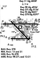
Runways
Runway Summary
| Runways: | 10L/28R 10R/28L |
| Longest Runway: | 10L/28R is 9000 ft (2743 m) long |
| Runways with an Instrument Approach: | 10L, 28R, 10R, 28L |
FLL Airport Runway Details
| Runway 10L/28R | 9000 ft x 150 ft (2743 m x 46 m) | |
| Runway Length Source: | 3RD PARTY SURVEY as of 01/27/2016 | |
| Surface: | Asphalt/Concrete - Excellent condition - Saw-cut or plastic grooved | |
| Runway Pavement Class: | 95 /R/B/W/T | |
| Runway Edge Lights: | High Intensity | |
Runway Weight Bearing Capacity (in thousands of pounds) |
||
| Single Wheel Landing Gear: | 100.0 | |
| Dual Wheel Landing Gear: | 200.0 | |
| Dual Tandem Wheel Landing Gear: | 468.0 | |
| Dual Dual Tandem Wheel Landing Gear: | 800.0 | |
Runway 10L |
Runway 28R |
|
Elevation: |
5.6 | 5.3 |
Latitude: |
26-04-37.0166N | 26-04-36.4507N |
Longitude: |
080-09-59.5381W | 080-08-20.8350W |
|
Runway True Alignment: |
090 | 270 |
ILS Type: |
ILS/DME | ILS/DME |
Glide Path Angle: |
3.0 degrees | 3.0 degrees |
Traffic Pattern: |
Left | Right |
Runway Markings Type: |
Precision Instrument | Precision Instrument |
Runway Markings Condition: |
Good | Good |
Arresting Device: |
EMAS | EMAS |
Object at End: |
ROAD | RR |
Object Height: |
14 | 33 |
Distance from End: |
340 | 470 |
Object Centerline Offset: |
0 ft. left and right of centerline | 530 ft. right of centerline |
Visual Glide Slope Indicators: |
4-Light PAPI On Left Side Of Runway | 4-Light PAPI On Left Side Of Runway |
Runway Visual Range (RVR): |
Touchdown | Touchdown |
Approach Light System: |
1,400 Foot Medium Intensity Approach Lighting System With Runway Alignment Indicator Lights | 1,400 Foot Medium Intensity Approach Lighting System With Runway Alignment Indicator Lights |
Threshold Crossing Height: |
66 | 69 |
Threshold Elevation: |
6.0 | 5.5 |
Displaced Threshold: |
576 | 606 |
Threshold Latitude: |
26-04-36.9818N | 26-04-36.4890N |
Threshold Longitude: |
080-09-53.2166W | 080-08-27.4831W |
Declared Distances |
||
Take Off Run Avbl. (TORA): |
9000 | 9000 |
Take Off Distance Avbl. (TODA): |
9000 | 9000 |
Actual Stop Dist. Avbl. (ASDA): |
9000 | 9000 |
Landing Dist. Avbl. (LDA): |
8424 | 8394 |
| Runway 10R/28L | 8000 ft x 150 ft (2438 m x 46 m) | |
| Runway Length Source: | 3RD PARTY SURVEY as of 01/27/2016 | |
| Surface: | Asphalt/Concrete - Excellent condition - Saw-cut or plastic grooved | |
| Runway Pavement Class: | 74 /R/B/W/T | |
| Runway Edge Lights: | High Intensity | |
Runway Weight Bearing Capacity (in thousands of pounds) |
||
| Single Wheel Landing Gear: | 120.0 | |
| Dual Wheel Landing Gear: | 247.0 | |
| Dual Tandem Wheel Landing Gear: | 461.0 | |
| Dual Dual Tandem Wheel Landing Gear: | 987.0 | |
Runway 10R |
Runway 28L |
|
Elevation: |
10.1 | 65.0 |
Latitude: |
26-03-57.1919N | 26-03-56.6718N |
Longitude: |
080-09-30.0560W | 080-08-02.3388W |
|
Runway True Alignment: |
090 | 270 |
ILS Type: |
ILS/DME | ILS/DME |
Glide Path Angle: |
3.0 degrees | 3.0 degrees |
Traffic Pattern: |
Right | |
Runway Markings Type: |
Precision Instrument | Precision Instrument |
Runway Markings Condition: |
Good | Good |
Arresting Device: |
EMAS | EMAS |
Object at End: |
POLE | |
Object Height: |
35 | |
Object Marked/Lighted?: |
Lighted | |
Distance from End: |
865 | |
Object Centerline Offset: |
0 ft. left and right of centerline | 530 ft. right of centerline |
Visual Glide Slope Indicators: |
4-Light PAPI On Right Side Of Runway | 4-Light PAPI On Left Side Of Runway |
Runway Visual Range (RVR): |
Touchdown | Touchdown |
Approach Light System: |
1,400 Foot Medium Intensity Approach Lighting System With Sequenced Flashers | 1,400 Foot Medium Intensity Approach Lighting System With Sequenced Flashers |
Threshold Crossing Height: |
71 | 69 |
Declared Distances |
||
Take Off Run Avbl. (TORA): |
8000 | 8000 |
Take Off Distance Avbl. (TODA): |
8000 | 8000 |
Actual Stop Dist. Avbl. (ASDA): |
8000 | 8000 |
Landing Dist. Avbl. (LDA): |
8000 | 8000 |
Services
Airframe Repair: |
None |
Powerplant Repair: |
None |
Bottled Oxygen: |
None |
Bulk Oxygen: |
None |
Fuel Available: |
100LL, Jet A, Jet A+ |
Landing Fees: |
No |
Parking: |
Hangars and tiedowns available |
Maps & Diagrams
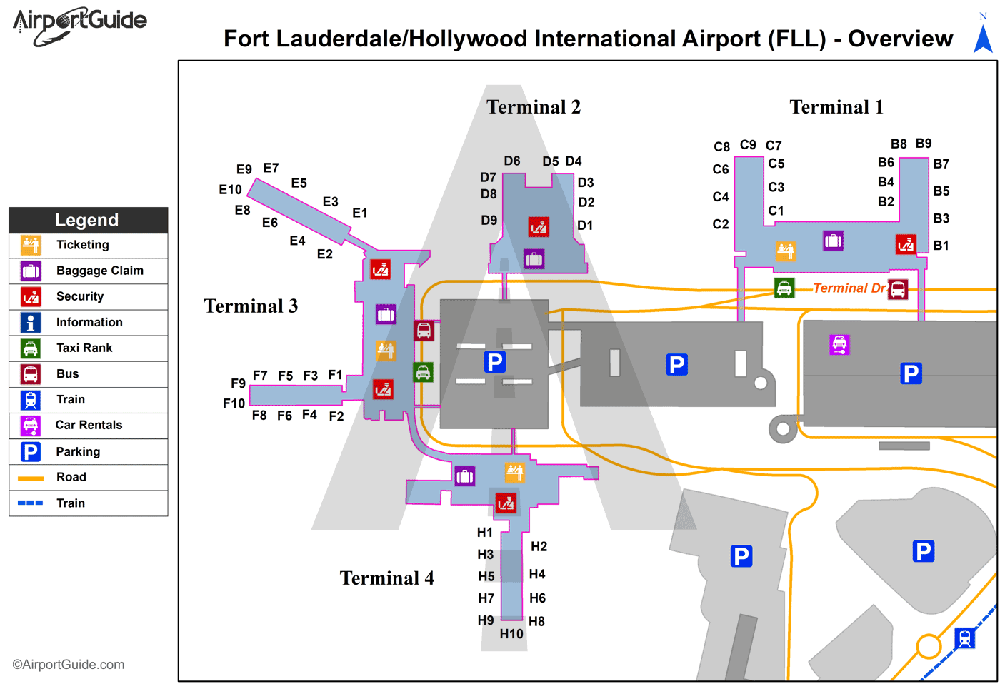
FLL Sectional
Flight Planning
at skyvector.com
at skyvector.com