Location
Latitude: |
38-18-55.2840N (38.315357) |
Longitude: |
076-33-00.4170W (-76.550116) |
Elevation: |
141.8 feet MSL (43 m MSL) |
Magnetic Variation: |
10.9 W (as of May 2024 from WMM2020 model) |
Time Zone: |
UTC -5.0 (Standard Time) UTC -4.0 (Daylight Savings Time) |
From City: |
04 N.M. NE of Leonardtown, Maryland |
Found On: |
Washington Chart |
FAA Region: |
AEA |
Contacts
Manager: |
Publicly owned: |
| ALLISON SWINT 44825 ST ANDREWS CHURCH ROAD CALIFORNIA, MD 20619 (301) 475-4200 |
THE COMMISSIONERS OF ST. MARYS CO. P.O. BOX 653, 41770 BALDRIDGE STREET LEONARDTOWN, MD 20650 301-475-4200 |
Operations
Airport Status: |
Operational |
Facility Use: |
Public |
Type: |
Airport |
Activation Date: |
12/1969 |
Control tower: |
No |
Attendance (Months/Days/Hours): |
Months/Days/Hours ALL/ALL/0800-1700 |
Boundary ARTCC: |
ZDC (Washington) |
Responsible ARTCC: |
ZDC (Washington) |
Lighting Schedule: |
SEE RMK |
Segmented Circle Indicator: |
Yes |
Traffic Pattern Altitude (MSL): |
1142 feet (348 m) |
NOTAMs Facility: |
DCA |
NOTAM-D Service: |
Yes |
International Airport of Entry: |
No |
Customs Landing Rights: |
No |
Military Landing Rights: |
Yes |
Civil/Military Joint Use: |
No |
Based Aircraft
| Single Engine: | 171 |
| Multi Engine: | 19 |
| Jet Engine: | 4 |
| GA Helicopters: | 5 |
| Gliders: | 7 |
| Ultralights: | 1 |
Annual Operations (as of 03/14/2023)
| Total Operations: | 40308 | |
| Air Taxi: | 1126 | 2.8% |
| GA Local: | 23380 | 58.0% |
| GA Itinerant: | 15586 | 38.7% |
| Military Aircraft: | 216 | 0.5% |
Communications
| CTAF: | 123.000 |
| Unicom: | 123.000 |
| Approach: | PATUXENT POTOMAC 135.625 ;WHEN NHK APCH CLSD 135.625 ;WHEN NHK APCH CLSD 135.625 ;WHEN NHK APCH CLSD 135.625 ;WHEN NHK APCH CLSD |
| Departure: | PATUXENT POTOMAC 135.625 ;WHEN NHK APCH CLSD 135.625 ;WHEN NHK APCH CLSD 135.625 ;WHEN NHK APCH CLSD 135.625 ;WHEN NHK APCH CLSD |
| AWOS-3: | 119.575 (301-373-6514) |
- APCH/DEP SVC PRVDD BY POTOMAC TRACON ON 135.625/269.625 WHEN PATUXENT APCH CTL CLSD.
Fixed Based Operators (FBOs) & Fuel
(Click on a business for detail)
Please help us keep this information up to date. This is a FREE SERVICE just like everything else on Airport Guide! If you see that a business needs to be added, modified, or deleted please fill out our Update Form.
To add, modify, or delete a business click here.
Please help us keep this information up to date. This is a FREE SERVICE just like everything else on Airport Guide! If you see that a business needs to be added, modified, or deleted please fill out our Update Form.
Area Code: 301 |
| Business Name | Frequency | Phone | Fuel Grade |
|---|
Flight Service Stations
| Primary | Alternate | |
| FSS on Field: | N | |
| FSS Name (ID): | Leesburg(DCA) | |
| Frequency: | ||
| Toll Free Phone: | 1-800-WX-BRIEF |
Instrument Procedures / Charts
FAA Terminal Procedures valid from 0901Z 03/21/24 to 0901Z 04/18/24.
There are various types of charts available for an airport. They are listed in the Page Type column. Here is a legend for those types:
APD - Airport Diagram
DP - Departure Procedure Charts
HOT - Hot Spots
IAP - Instrument Approach Procedure Charts
MIN - Minimums
STAR - Standard Terminal Arrival Charts
| Page Type | Page Name | Volume | Action Since Last Cycle |
|---|---|---|---|
| IAP | RNAV (GPS) RWY 11 | NE-3 | |
| IAP | RNAV (GPS) RWY 29 | NE-3 | |
| MIN | ALTERNATE MINIMUMS | NE-3 | |
| MIN | TAKEOFF MINIMUMS | NE-3 |
Terminal Procedures are only available for airports in several countries with more being added all the time. If you are looking for a specific country's charts, please send an email to support(at)airportguide.com stating the country name. This will be used to prioritize the implementation.
Navigation Aids (Navaids) near LTW
| Dist (NM) | ID | Morse Code | Name | Type | Freq | True Hdg | Mag Hdg |
|---|---|---|---|---|---|---|---|
| 6.9 | NHK | _ . . . . . _ . _ | Nas Patuxent River | TACAN | 110.25 | 107 | 118 |
| 7.1 | NHK | _ . . . . . _ . _ | Patuxent | NDB | 400 | 104 | 115 |
| 7.2 | PXT | . _ _ . _ . . _ _ | Patuxent | VORTAC | 117.60 | 103 | 114 |
| 25.2 | OTT | _ _ _ _ _ | Nottingham | VORTAC | 113.70 | 338 | 349 |
| 27.8 | CGE | _ . _ . _ _ . . | Cambridge | NDB | 355 | 61 | 72 |
| 33.0 | ADW | . _ _ . . . _ _ | Andrews | VORTAC | 113.10 | 333 | 344 |
| 33.2 | ADW | . _ _ . . . _ _ | Andrews Afb | VOT | 109.60 | 332 | 343 |
| 33.5 | DAA | _ . . . _ . _ | Davee | NDB | 223 | 308 | 319 |
| 35.1 | DCA | _ . . _ . _ . . _ | Oxonn | NDB | 332 | 320 | 331 |
| 37.8 | BRV | _ . . . . _ . . . . _ | Brooke | VORTAC | 114.50 | 272 | 283 |
| 39.8 | DCA | _ . . _ . _ . . _ | Washington | VOR-DME | 111.00 | 325 | 336 |
| 42.5 | EZF | . _ _ . . . . _ . | Shannon | NDB | 237 | 266 | 277 |
| 45.6 | GTN | _ _ . _ _ . | Georgetown | NDB | 323 | 324 | 335 |
| 47.2 | BUH | _ . . . . . _ . . . . | Anne Arundel | NDB | 260 | 348 | 359 |
| 49.0 | SBY | . . . _ . . . _ . _ _ | Salisbury | VORTAC | 111.20 | 87 | 98 |
| 51.6 | BAL | _ . . . . _ . _ . . | Baltimore | VORTAC | 115.10 | 354 | 365 |
| 52.6 | HCM | . . . . _ . _ . _ _ | Harcum | VORTAC | 108.80 | 188 | 199 |
| 53.5 | SWL | . . . . _ _ . _ . . | Snow Hill | VORTAC | 112.40 | 106 | 117 |
| 56.8 | AML | . _ _ _ . _ . . | Armel | VOR-DME | 113.50 | 311 | 322 |
| 57.1 | BDB | _ . . . _ . . _ . . . | Accom | NDB | 336 | 141 | 152 |
Nearby Airports with Fuel
Notices to Airmen (NOTAMS)
Remarks
| A110*G | THIS AIRPORT HAS BEEN SURVEYED BY THE NATIONAL GEODETIC SURVEY. |
| A110-1 | DEER ON & INVOF RWY 11/29 SS-SR. |
| A110-2 | GLDR, UAS, AND ULTRALIGHT ACTVT ON & INVOF ARPT. |
| A110-4 | RWY 29 15 FT DEPRESSION (DOWNSLOPE) 300 FT FM THR 150 FT R-125 L. |
| A110-5 | FOR CD CTC PATUXENT APCH AT 301-342-3740, WHEN PATUXENT APCH IS CLSD CTC POTOMAC APCH AT 866-640-4124. |
| A110-6 | WHEN R-4007 IN EFFECT, ACFT OPRNG VFR AT ARPT MUST RMN WITHIN 1.5 NM OF ARPT, AT OR BLW 1500 FT MSL, AND ABV 700 FT AGL. |
| A110-7 | ALL VFR FLT OPS CONDUCTED WI R-4007 SHALL BE AT OR BLW 1000 FT MSL. IFR AND VFR APCHS WI R-4007 WILL BE COORDD WITH PATUXENT APCH ON 121.0 OR BY PHONE 301-342-3740. |
| A110-8 | MIL ACFT ON INSTR APCH TO PAX RIVER NAS MAY OVERFLY ARPT AT 1600 FT MSL & NOT MNT CTAF. WHEN PAX RWY 14 IN USE, 2W6 ACFT CROSS APCH PATH AT OR BLW 1000 FT OR ABOVE 3000 FT. MIL HELO OPS INVOF ARPT. |
| A13 | EXT 1321 |
| A15 | AIRPORT PHYSICAL ADDRESS IS 44200 AIRPORT ROAD, CALIFORNIA, MD 20619. |
| A16 | EXT 3511 |
| A33-11/29 | UNFILLED CRACKS, VEGETATIVE GROWTH, OXIDATION, RAVELLING. |
| A42-29 | FADED. |
| A58-11 | 30 FT TREES AT THLD, 160 FT L. |
| A70-FUEL-10 | 0LL SELF SERVE 100LL AVBL WITH CREDIT CARD. |
| A81-APT | ACTVT REIL RWYS 11 & 29; MIRL RWY 11/29 - CTAF. |
Runways
Runway Summary
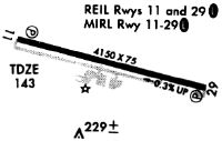
| Runways: | 11/29 |
| Longest Runway: | 11/29 is 4150 ft (1265 m) long |
| Runways with an Instrument Approach: |
LTW Airport Runway Details
| Runway 11/29 | 4150 ft x 75 ft (1265 m x 23 m) | |
| Runway Length Source: | NGS as of 12/11/2006 | |
| Surface: | Asphalt - Fair condition - No special surface treatment | |
| Runway Edge Lights: | Medium Intensity | |
Runway Weight Bearing Capacity (in thousands of pounds) |
||
| Single Wheel Landing Gear: | 12.5 | |
Runway 11 |
Runway 29 |
|
Elevation: |
141.8 | 125.1 |
Latitude: |
38-18-59.6584N | 38-18-50.9088N |
Longitude: |
076-33-25.8506W | 076-32-34.9851W |
|
Runway True Alignment: |
102 | 282 |
Glide Path Angle: |
3.0 degrees | 3.0 degrees |
Traffic Pattern: |
Left | Left |
Runway Markings Type: |
Nonprecision Instrument | Nonprecision Instrument |
Runway Markings Condition: |
Good | Fair |
Object at End: |
HILL | TREES |
Object Height: |
15 | 44 |
Distance from End: |
502 | 1436 |
Object Centerline Offset: |
88 ft. left of centerline | 25 ft. left of centerline |
Visual Glide Slope Indicators: |
2-Light PAPI On Left Side Of Runway | 2-Light PAPI On Left Side Of Runway |
REIL: |
Yes | Yes |
Threshold Crossing Height: |
37 | 32 |
Services
Airframe Repair: |
Minor |
Powerplant Repair: |
Minor |
Bottled Oxygen: |
None |
Bulk Oxygen: |
None |
Fuel Available: |
100LL |
Landing Fees: |
No |
Parking: |
Hangars and tiedowns available |
Other Services: |
Tailwheel instruction |
Maps & Diagrams
LTW Sectional
Flight Planning
at skyvector.com
at skyvector.com