Location
Latitude: |
37-42-32.2000N (37.708944) |
Longitude: |
077-26-11.9000W (-77.436639) |
Elevation: |
206.5 feet MSL (63 m MSL) |
Magnetic Variation: |
10.3 W (as of April 2024 from WMM2020 model) |
Time Zone: |
UTC -5.0 (Standard Time) UTC -4.0 (Daylight Savings Time) |
From City: |
08 N.M. N of Richmond/Ashland, Virginia |
Found On: |
Washington Chart |
FAA Region: |
AEA |
Contacts
Manager: |
Publicly owned: |
| CHARLES J SOBRITO DEPARTMENT OF PUBLIC WORKS, PO BOX 470 HANOVER, VA 23069 804-365-6208 |
COUNTY OF HANOVER DIRECTOR OF PUBLIC WORKS HANOVER, VA 23069 804-365-6179 |
Operations
Airport Status: |
Operational |
Facility Use: |
Public |
Type: |
Airport |
Activation Date: |
02/1971 |
Control tower: |
No |
Attendance (Months/Days/Hours): |
Months/Days/Hours JAN - DEC/ALL/0700-1900 |
Boundary ARTCC: |
ZDC (Washington) |
Responsible ARTCC: |
ZDC (Washington) |
Lighting Schedule: |
SEE RMK |
Segmented Circle Indicator: |
Yes |
Traffic Pattern Altitude (MSL): |
1206 feet (368 m) |
NOTAMs Facility: |
OFP |
NOTAM-D Service: |
Yes |
International Airport of Entry: |
No |
Customs Landing Rights: |
No |
Civil/Military Joint Use: |
No |
Based Aircraft
| Single Engine: | 93 |
| Multi Engine: | 5 |
| Jet Engine: | 2 |
| GA Helicopters: | 2 |
Annual Operations (as of 12/31/2018)
| Total Operations: | 36165 | |
| Air Taxi: | 1119 | 3.1% |
| GA Local: | 25581 | 70.7% |
| GA Itinerant: | 9465 | 26.2% |
Communications
| CTAF: | 122.700 |
| Unicom: | 122.700 |
| Approach: | POTOMAC 118.2 118.2 118.2 118.2 118.2 |
| Departure: | POTOMAC 118.2 118.2 118.2 118.2 118.2 |
| ASOS: | 119.025 (804-752-2902) |
- APCH/DEP SVC PRVDD BY POTOMAC TRACON 126.75/307.2.
Fixed Based Operators (FBOs) & Fuel
(Click on a business for detail)
Please help us keep this information up to date. This is a FREE SERVICE just like everything else on Airport Guide! If you see that a business needs to be added, modified, or deleted please fill out our Update Form.
To add, modify, or delete a business click here.
Please help us keep this information up to date. This is a FREE SERVICE just like everything else on Airport Guide! If you see that a business needs to be added, modified, or deleted please fill out our Update Form.
Area Code: 804 |
| Business Name | Frequency | Phone | Fuel Grade |
|---|---|---|---|
| Sundance Aviation, Inc.
Update FBO info |
Unicom 122.7 | 798-6500 |
Flight Service Stations
| Primary | Alternate | |
| FSS on Field: | N | |
| FSS Name (ID): | Leesburg(DCA) | |
| Frequency: | ||
| Toll Free Phone: | 1-800-WX-BRIEF |
Instrument Procedures / Charts
FAA Terminal Procedures valid from 0901Z 03/21/24 to 0901Z 04/18/24.
There are various types of charts available for an airport. They are listed in the Page Type column. Here is a legend for those types:
APD - Airport Diagram
DP - Departure Procedure Charts
HOT - Hot Spots
IAP - Instrument Approach Procedure Charts
MIN - Minimums
STAR - Standard Terminal Arrival Charts
| Page Type | Page Name | Volume | Action Since Last Cycle |
|---|---|---|---|
| IAP | LOC RWY 16 | NE-3 | |
| IAP | RNAV (GPS) RWY 16 | NE-3 | |
| IAP | RNAV (GPS) RWY 34 | NE-3 | |
| IAP | VOR RWY 16 | NE-3 | |
| MIN | ALTERNATE MINIMUMS | NE-3 | |
| MIN | TAKEOFF MINIMUMS | NE-3 |
Terminal Procedures are only available for airports in several countries with more being added all the time. If you are looking for a specific country's charts, please send an email to support(at)airportguide.com stating the country name. This will be used to prioritize the implementation.
Navigation Aids (Navaids) near KOFP
| Dist (NM) | ID | Morse Code | Name | Type | Freq | True Hdg | Mag Hdg |
|---|---|---|---|---|---|---|---|
| 13.6 | RIC | . _ . . . _ . _ . | Richmond | VORTAC | 114.10 | 155 | 165 |
| 21.5 | FAK | . . _ . . _ _ . _ | Flat Rock | VORTAC | 113.30 | 239 | 249 |
| 22.6 | CF | _ . _ . . . _ . | Pubbs | NDB | 392 | 182 | 192 |
| 27.4 | HPW | . . . . . _ _ . . _ _ | Hopewell | VORTAC | 112.00 | 146 | 156 |
| 33.4 | EZF | . _ _ . . . . _ . | Shannon | NDB | 237 | 358 | 368 |
| 37.8 | BRV | _ . . . . _ . . . . _ | Brooke | VORTAC | 114.50 | 5 | 15 |
| 37.9 | HCM | . . . . _ . _ . _ _ | Harcum | VORTAC | 108.80 | 114 | 125 |
| 38.5 | GVE | _ _ . . . . _ . | Gordonsville | VORTAC | 115.60 | 298 | 308 |
| 45.3 | BKT | _ . . . _ . _ _ | Blackstone | NDB | 326 | 219 | 229 |
| 48.3 | AKQ | . _ _ . _ _ _ . _ | Wakefield | NDB | 274 | 154 | 164 |
| 49.9 | MSQ | _ _ . . . _ _ . _ | Nailr | NDB | 351 | 333 | 343 |
| 51.9 | FAF | . . _ . . _ . . _ . | Felker | NDB | 226 | 131 | 142 |
| 52.2 | FVX | . . _ . . . . _ _ . . _ | Farmville | NDB | 367 | 246 | 256 |
| 54.3 | AZS | . _ _ _ . . . . . | Azalea Park | NDB | 336 | 289 | 299 |
| 56.7 | PJS | . _ _ . . _ _ _ . . . | Henry | NDB | 375 | 127 | 138 |
| 57.9 | LVL | . _ . . . . . _ . _ . . | Lawrenceville | VORTAC | 112.90 | 202 | 212 |
| 59.2 | DAA | _ . . . _ . _ | Davee | NDB | 223 | 14 | 25 |
| 59.4 | NHK | _ . . . . . _ . _ | Nas Patuxent River | TACAN | 110.25 | 54 | 65 |
| 59.5 | CSN | _ . _ . . . . _ . | Casanova | VORTAC | 116.30 | 340 | 350 |
| 59.9 | NHK | _ . . . . . _ . _ | Patuxent | NDB | 400 | 54 | 65 |
Nearby Airports with Fuel
Notices to Airmen (NOTAMS)
Remarks
| A110*G | THIS AIRPORT HAS BEEN SURVEYED BY THE NATIONAL GEODETIC SURVEY. |
| A110-2 | NOISE SENSITIVE AREA SOUTH OF ARPT. |
| A110-3 | FOR ARPT SERVICES CALL 804-798-6500. |
| A110-4 | DEER & BIRDS ON & INVOF ARPT. |
| A110-5 | FOR CD CTC POTOMAC APCH AT 866-640-4124. |
| A110-6 | RWY 34 PREF RWY WITH WIND LESS THAN 5 KT. |
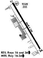
| A81-APT | ACTVT REIL RWYS 16 & 34; MIRL RWY 16/34 - CTAF. |
Runways
Runway Summary
| Runways: | 16/34 |
| Longest Runway: | 16/34 is 5402 ft (1647 m) long |
| Runways with an Instrument Approach: | 16 |
KOFP Airport Runway Details
| Runway 16/34 | 5402 ft x 100 ft (1647 m x 30 m) | |
| Runway Length Source: | NGS as of 10/13/2006 | |
| Surface: | Asphalt - Good condition - Porous friction course | |
| Runway Edge Lights: | Medium Intensity | |
Runway Weight Bearing Capacity (in thousands of pounds) |
||
| Single Wheel Landing Gear: | 40.0 | |
Runway 16 |
Runway 34 |
|
Elevation: |
206.5 | 201.2 |
Latitude: |
37-42-55.2292N | 37-42-09.1243N |
Longitude: |
077-26-28.8552W | 077-25-54.9411W |
|
Runway True Alignment: |
150 | 330 |
ILS Type: |
LOC/DME | |
Glide Path Angle: |
3.0 degrees | 0.0 degrees |
Traffic Pattern: |
Left | Left |
Runway Markings Type: |
Nonprecision Instrument | Nonprecision Instrument |
Runway Markings Condition: |
Fair | Fair |
Object at End: |
TREE | TREES |
Object Height: |
108 | 95 |
Distance from End: |
2901 | 3328 |
Object Centerline Offset: |
42 ft. left of centerline | 273 ft. right of centerline |
Visual Glide Slope Indicators: |
4-Light PAPI On Left Side Of Runway | |
REIL: |
Yes | Yes |
Threshold Crossing Height: |
40 |
Services
Airframe Repair: |
Major |
Powerplant Repair: |
Major |
Bottled Oxygen: |
None |
Bulk Oxygen: |
None |
Fuel Available: |
100LL, Jet A+ |
Landing Fees: |
No |
Parking: |
Hangars and tiedowns available |
Maps & Diagrams
KOFP Sectional
Flight Planning
at skyvector.com
at skyvector.com