Location
Latitude: |
46-18-53.1030N (46.314751) |
Longitude: |
091-48-58.9530W (-91.816376) |
Elevation: |
1102.1 feet MSL (336 m MSL) |
Magnetic Variation: |
1.4 W (as of April 2024 from WMM2020 model) |
Time Zone: |
UTC -6.0 (Standard Time) UTC -5.0 (Daylight Savings Time) |
From City: |
03 N.M. S of Solon Springs, Wisconsin |
Found On: |
Green Bay Chart |
FAA Region: |
AGL |
Contacts
Manager: |
Publicly owned: |
| NEIL MATHISON 11268 S TWIN LAKE RD SOLON SPRINGS, WI 54573 (218) 348-3176 |
TOWN OF SOLON SPRINGS ARPT COMM P.O. BOX 36 SOLON SPRINGS, WI 54873 715-378-2235 |
Operations
Airport Status: |
Operational |
Facility Use: |
Public |
Type: |
Airport |
Activation Date: |
08/1952 |
Control tower: |
No |
Attendance (Months/Days/Hours): |
Months/Days/Hours Unattended |
Boundary ARTCC: |
ZMP (Minneapolis) |
Responsible ARTCC: |
ZMP (Minneapolis) |
Lighting Schedule: |
SEE RMK |
Segmented Circle Indicator: |
No |
Traffic Pattern Altitude (MSL): |
2102 feet (641 m) |
NOTAMs Facility: |
GRB |
NOTAM-D Service: |
Yes |
International Airport of Entry: |
No |
Customs Landing Rights: |
No |
Military Landing Rights: |
No |
Civil/Military Joint Use: |
No |
Based Aircraft
| Single Engine: | 15 |
Annual Operations (as of 07/29/2021)
| Total Operations: | 4525 | |
| Air Taxi: | 25 | 0.6% |
| GA Local: | 1250 | 27.6% |
| GA Itinerant: | 3250 | 71.8% |
Communications
| CTAF: | 122.900 |
| Approach: | DULUTH 125.45 125.45 |
| Departure: | DULUTH 125.45 125.45 |
| AWOS-3: | 119.6 (715-378-2031) |
Fixed Based Operators (FBOs) & Fuel
(Click on a business for detail)
Please help us keep this information up to date. This is a FREE SERVICE just like everything else on Airport Guide! If you see that a business needs to be added, modified, or deleted please fill out our Update Form.
To add, modify, or delete a business click here.
Please help us keep this information up to date. This is a FREE SERVICE just like everything else on Airport Guide! If you see that a business needs to be added, modified, or deleted please fill out our Update Form.
Area Code: 715 |
| Business Name | Frequency | Phone | Fuel Grade |
|---|---|---|---|
| McLeod Air Center
Update FBO info |
Unicom 122.9 | 378-2424, -2881 | Mogas |
| Quality Connection Aviation
Update FBO info |
399-8564 |
Flight Service Stations
| Primary | Alternate | |
| FSS on Field: | N | |
| FSS Name (ID): | Green Bay(GRB) | |
| Frequency: | ||
| Toll Free Phone: | 1-800-WX-BRIEF |
Instrument Procedures / Charts
FAA Terminal Procedures valid from 0901Z 03/21/24 to 0901Z 04/18/24.
There are various types of charts available for an airport. They are listed in the Page Type column. Here is a legend for those types:
APD - Airport Diagram
DP - Departure Procedure Charts
HOT - Hot Spots
IAP - Instrument Approach Procedure Charts
MIN - Minimums
STAR - Standard Terminal Arrival Charts
| Page Type | Page Name | Volume | Action Since Last Cycle |
|---|---|---|---|
| IAP | RNAV (GPS) RWY 19 | EC-3 | |
| MIN | TAKEOFF MINIMUMS | EC-3 |
Terminal Procedures are only available for airports in several countries with more being added all the time. If you are looking for a specific country's charts, please send an email to support(at)airportguide.com stating the country name. This will be used to prioritize the implementation.
Navigation Aids (Navaids) near KOLG
| Dist (NM) | ID | Morse Code | Name | Type | Freq | True Hdg | Mag Hdg |
|---|---|---|---|---|---|---|---|
| 23.5 | HYR | . . . . _ . _ _ . _ . | Hayward | DME | 113.4 | 138 | 140 |
| 33.3 | DLH | _ . . . _ . . . . . . | Duluth | VORTAC | 112.60 | 331 | 332 |
| 35.2 | LKI | . _ . . _ . _ . . | Lakeside | TACAN | 135.40 | 334 | 335 |
| 36.5 | COQ | _ . _ . _ _ _ _ _ . _ | Cloquet | NDB | 335 | 309 | 310 |
| 37.4 | BXR | _ . . . _ . . _ . _ . | Big Doctor | NDB | 203 | 217 | 218 |
| 37.7 | RZN | . _ . _ _ . . _ . | Siren | DME | 109.4 | 218 | 219 |
| 38.8 | DL | _ . . . _ . . | Pykla | NDB | 379 | 325 | 326 |
| 39.8 | ASX | . _ . . . _ . . _ | Ashland | VOR-DME | 110.20 | 68 | 70 |
| 41.4 | MZH | _ _ _ _ . . . . . . | Moose Lake | NDB | 362 | 278 | 279 |
| 54.0 | RPD | . _ . . _ _ . _ . . | Rice Lake | VOR-DME | 110.00 | 178 | 179 |
| 58.5 | BFW | _ . . . . . _ . . _ _ | Silver Bay | NDB | 350 | 16 | 18 |
| 59.5 | RCX | . _ . _ . _ . _ . . _ | Rusk County | NDB | 356 | 144 | 146 |
| 59.8 | RP | . _ . . _ _ . | Wickr | NDB | 221 | 179 | 180 |
| 60.3 | ROS | . _ . _ _ _ . . . | Rush City | NDB | 282 | 232 | 233 |
| 61.7 | PKF | . _ _ . _ . _ . . _ . | Park Falls | NDB | 371 | 110 | 112 |
| 65.6 | JMR | . _ _ _ _ _ . _ . | Mora | NDB | 327 | 247 | 248 |
| 69.0 | PBH | . _ _ . _ . . . . . . . | Phillips | NDB | 263 | 121 | 123 |
| 69.5 | HIB | . . . . . . _ . . . | Hibbing | VOR-DME | 110.80 | 328 | 329 |
| 71.1 | IWD | . . . _ _ _ . . | Ironwood | VOR-DME | 108.80 | 78 | 80 |
| 72.1 | EVM | . . . . _ _ _ | Eveleth | VOR-DME | 108.20 | 337 | 338 |
Nearby Airports with Fuel
Notices to Airmen (NOTAMS)
Remarks
| A11 | TOWN AND VILLAGE OF SOLON SPRINGS |
| A110-3 | NUMEROUS DEER ON ARPT. |
| A110-4 | FOR CD CTC DULUTH APCH AT 218-740-5950. |
| A15 | EMAIL ADDRESS: SKIPMATH@AOL.COM (ALL LOWER CASE) |
| A30A-H1 | TLOF 40X40 FT, FATO 75X65 FT. |
| A70-FUEL-10 | 0LL 24 HR SELF SVC WITH CREDIT CARD. |
| A71 | ACFT MECH ON CALL 218-269-2433. |
| A81-APT | ACTVT REIL RWY 01 & 19; PAPI RWY 01 & 19; MIRL RWY 01/19 - CTAF. |
Runways
Runway Summary
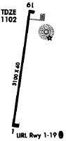
| Runways: | 01/19 H1 |
| Longest Runway: | 01/19 is 3099 ft (945 m) long |
| Runways with an Instrument Approach: |
KOLG Airport Runway Details
| Runway 01/19 | 3099 ft x 60 ft (945 m x 18 m) | |
| Runway Length Source: | 3RD PARTY SURVEY as of 09/24/2009 | |
| Surface: | Asphalt - Excellent condition - No special surface treatment | |
| Runway Edge Lights: | Medium Intensity | |
Runway Weight Bearing Capacity (in thousands of pounds) |
||
| Single Wheel Landing Gear: | 27.0 | |
Runway 01 |
Runway 19 |
|
Elevation: |
1101.3 | 1100.5 |
Latitude: |
46-18-37.9578N | 46-19-08.2638N |
Longitude: |
091-49-01.9326W | 091-48-55.9750W |
|
Runway True Alignment: |
008 | 188 |
Glide Path Angle: |
3.0 degrees | 3.5 degrees |
Traffic Pattern: |
Left | Left |
Runway Markings Type: |
Nonprecision Instrument | Nonprecision Instrument |
Runway Markings Condition: |
Good | Good |
Visual Glide Slope Indicators: |
2-Light PAPI On Left Side Of Runway | 2-Light PAPI On Left Side Of Runway |
REIL: |
Yes | Yes |
Touchdown Lights: |
No | No |
Centerline Lights: |
No | No |
Threshold Crossing Height: |
26 | 20 |
| Helipad H1 | 40 ft x 40 ft (12 m x 12 m) | |
| Runway Length Source: | STATE as of 03/17/2017 | |
| Surface: | Asphalt - Excellent condition - No special surface treatment | |
| Runway Edge Lights: | Perimeter lights (for helipads) Intensity | |
Helipad H1 |
||
Elevation: |
1090.0 | |
Latitude: |
46-19-08.0300N | |
Longitude: |
091-48-51.9000W | |
Glide Path Angle: |
0.0 degrees | 0.0 degrees |
Services
Airframe Repair: |
Major |
Powerplant Repair: |
Minor |
Bottled Oxygen: |
None |
Bulk Oxygen: |
None |
Fuel Available: |
100LL |
Landing Fees: |
No |
Parking: |
Tiedowns available |
Maps & Diagrams
KOLG Sectional
Flight Planning
at skyvector.com
at skyvector.com