Location
Latitude: |
46-11-41.7590N (46.194933) |
Longitude: |
091-14-54.4310W (-91.248453) |
Elevation: |
1360.4 feet MSL (415 m MSL) |
Magnetic Variation: |
1.8 W (as of April 2024 from WMM2020 model) |
Time Zone: |
UTC -6.0 (Standard Time) UTC -5.0 (Daylight Savings Time) |
From City: |
02 N.M. SE of Cable, Wisconsin |
Found On: |
Green Bay Chart |
FAA Region: |
AGL |
Contacts
Manager: |
Publicly owned: |
| MIKE NICHOLS 42905 TELEMARK RD, PO BOX 248 CABLE, WI 54821 715-798-3240 |
TOWN OF CABLE PO BOX 476 CABLE, WI 54821 715-798-4440 |
Operations
Airport Status: |
Operational |
Facility Use: |
Public |
Type: |
Airport |
Activation Date: |
03/1949 |
Control tower: |
No |
Attendance (Months/Days/Hours): |
Months/Days/Hours Unattended |
Boundary ARTCC: |
ZMP (Minneapolis) |
Responsible ARTCC: |
ZMP (Minneapolis) |
Lighting Schedule: |
SEE RMK |
Segmented Circle Indicator: |
No |
Traffic Pattern Altitude (MSL): |
2360 feet (719 m) |
NOTAMs Facility: |
GRB |
NOTAM-D Service: |
Yes |
International Airport of Entry: |
No |
Customs Landing Rights: |
No |
Military Landing Rights: |
Yes |
Civil/Military Joint Use: |
No |
Based Aircraft
| Single Engine: | 7 |
| Multi Engine: | 3 |
Annual Operations (as of 07/29/2021)
| Total Operations: | 5510 | |
| Air Taxi: | 500 | 9.1% |
| GA Local: | 2000 | 36.3% |
| GA Itinerant: | 3000 | 54.4% |
| Military Aircraft: | 10 | 0.2% |
Communications
| CTAF: | 122.800 |
| Unicom: | 122.800 |
- APCH/DEP SVC PRVDD BY MINNEAPOLIS ARTCC ON FREQS 126.45/276.4 (HAYWARD RCAG).
Fixed Based Operators (FBOs) & Fuel
(Click on a business for detail)
Please help us keep this information up to date. This is a FREE SERVICE just like everything else on Airport Guide! If you see that a business needs to be added, modified, or deleted please fill out our Update Form.
To add, modify, or delete a business click here.
Please help us keep this information up to date. This is a FREE SERVICE just like everything else on Airport Guide! If you see that a business needs to be added, modified, or deleted please fill out our Update Form.
Area Code: 715 |
| Business Name | Frequency | Phone | Fuel Grade |
|---|---|---|---|
| Parod Flying Service
Update FBO info |
798-3240 | 100LL |
Flight Service Stations
| Primary | Alternate | |
| FSS on Field: | N | |
| FSS Name (ID): | Green Bay(GRB) | |
| Frequency: | ||
| Toll Free Phone: | 1-800-WX-BRIEF |
Instrument Procedures / Charts
FAA Terminal Procedures valid from 0901Z 03/21/24 to 0901Z 04/18/24.
There are various types of charts available for an airport. They are listed in the Page Type column. Here is a legend for those types:
APD - Airport Diagram
DP - Departure Procedure Charts
HOT - Hot Spots
IAP - Instrument Approach Procedure Charts
MIN - Minimums
STAR - Standard Terminal Arrival Charts
| Page Type | Page Name | Volume | Action Since Last Cycle |
|---|---|---|---|
| IAP | RNAV (GPS) RWY 35 | EC-3 | |
| MIN | TAKEOFF MINIMUMS | EC-3 |
Terminal Procedures are only available for airports in several countries with more being added all the time. If you are looking for a specific country's charts, please send an email to support(at)airportguide.com stating the country name. This will be used to prioritize the implementation.
Navigation Aids (Navaids) near 3CU
| Dist (NM) | ID | Morse Code | Name | Type | Freq | True Hdg | Mag Hdg |
|---|---|---|---|---|---|---|---|
| 13.4 | HYR | . . . . _ . _ _ . _ . | Hayward | DME | 113.4 | 218 | 220 |
| 25.3 | ASX | . _ . . . _ . . _ | Ashland | VOR-DME | 110.20 | 32 | 34 |
| 37.2 | PKF | . _ _ . _ . _ . . _ . | Park Falls | NDB | 371 | 112 | 114 |
| 42.9 | RCX | . _ . _ . _ . _ . . _ | Rusk County | NDB | 356 | 165 | 167 |
| 45.7 | PBH | . _ _ . _ . . . . . . . | Phillips | NDB | 263 | 129 | 131 |
| 50.7 | IWD | . . . _ _ _ . . | Ironwood | VOR-DME | 108.80 | 66 | 68 |
| 51.7 | BXR | _ . . . _ . . _ . _ . | Big Doctor | NDB | 203 | 244 | 245 |
| 51.8 | RPD | . _ . . _ _ . _ . . | Rice Lake | VOR-DME | 110.00 | 205 | 207 |
| 52.0 | RZN | . _ . _ _ . . _ . | Siren | DME | 109.4 | 244 | 245 |
| 53.7 | DLH | _ . . . _ . . . . . . | Duluth | VORTAC | 112.60 | 313 | 314 |
| 54.9 | LKI | . _ . . _ . _ . . | Lakeside | TACAN | 135.40 | 315 | 316 |
| 57.5 | RP | . _ . . _ _ . | Wickr | NDB | 221 | 203 | 205 |
| 60.0 | COQ | _ . _ . _ _ _ _ _ . _ | Cloquet | NDB | 335 | 300 | 301 |
| 60.1 | DL | _ . . . _ . . | Pykla | NDB | 379 | 310 | 311 |
| 63.7 | BFW | _ . . . . . _ . . _ _ | Silver Bay | NDB | 350 | 353 | 355 |
| 65.3 | ARV | . _ . _ . . . . _ | Arbor Vitae | NDB | 221 | 103 | 105 |
| 65.9 | MZH | _ _ _ _ . . . . . . | Moose Lake | NDB | 362 | 282 | 283 |
| 66.3 | BDJ | _ . . . _ . . . _ _ _ | Boulder Junction | NDB | 206 | 92 | 94 |
| 66.9 | DO | _ . . _ _ _ | Dougy | NDB | 236 | 108 | 110 |
| 75.2 | EA | . . _ | Maggs | NDB | 239 | 184 | 186 |
Nearby Airports with Fuel
Notices to Airmen (NOTAMS)
Remarks
| A11 | AND TOWN OF DRUMMOND & NAMEGAGON. |
| A110-1 | RY 08/26 CLSD NOV 21 - MAY 1. |
| A110-3 | TWY LGTS AT ENTRANCE TO TWY ONLY. |
| A110-4 | PLUG IN AVBL. NO HEATING UNITS AVBL TO START ACFT. |
| A110-5 | RY CONDITIONS NOT REPORTED. |
| A110-6 | FOR CD CTC MINNEAPOLIS ARTCC AT 651-463-5588. |
| A110-7 | FQT DEER ON & INVOF ARPT. |
| A42-08 | RWY 08/26 MKD WITH YELLOW CONES. |
| A57-08 | APCH RATIO 18:1 TO DSPLCD THR; 60 FT TREES 1023 FT FM DSPCLD THR, ON CNTRLN. |
| A57-17 | APCH RATIO 12:1 TO DSPLCD THR; 35 FT TREES 420 FT FM DSPCLD THR, 220 FT R. |
| A57-35 | RWY 35 APCH RATIO 16:1 TO DSPLCD THLD. |
| A58-35 | 30 FT TREES 180 FT FM RWY END, 240 FT L. |
| A70-FUEL-10 | 0LL 24 HR FUEL AVBL WITH CREDIT CARD. |
| A81-APT | MIRL RWY 17/35 PRESET LOW INTST TO INCR INTST AND ACTVT - CTAF. |
Runways
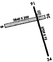
Runway Summary
| Runways: | 08/26 17/35 |
| Longest Runway: | 17/35 is 3709 ft (1131 m) long |
| Runways with an Instrument Approach: |
3CU Airport Runway Details
| Runway 08/26 | 2194 ft x 150 ft (669 m x 46 m) | |
| Runway Length Source: | ADO as of 04/08/2019 | |
| Surface: | Turf - Good condition - No special surface treatment | |
Runway 08 |
Runway 26 |
|
Elevation: |
1344.0 | 1344.0 |
Latitude: |
46-11-43.6883N | 46-11-48.1400N |
Longitude: |
091-15-22.1194W | 091-14-51.6000W |
|
Runway True Alignment: |
078 | 258 |
Glide Path Angle: |
0.0 degrees | 0.0 degrees |
Traffic Pattern: |
Left | Left |
Runway Markings Type: |
None | None |
Runway Markings Condition: |
Fair | Fair |
Object at End: |
TREES | |
Object Height: |
60 | |
Distance from End: |
645 | |
Object Centerline Offset: |
0 ft. left and right of centerline | |
REIL: |
No | No |
Touchdown Lights: |
No | No |
Centerline Lights: |
No | No |
Threshold Elevation: |
1344.0 | |
Displaced Threshold: |
378 | |
Threshold Latitude: |
46-11-44.4876N | |
Threshold Longitude: |
091-15-16.8700W |
| Runway 17/35 | 3709 ft x 75 ft (1131 m x 23 m) | |
| Runway Length Source: | 3RD PARTY SURVEY as of 09/29/2010 | |
| Surface: | Turf - Good condition - No special surface treatment | |
| Runway Edge Lights: | Medium Intensity | |
Runway Weight Bearing Capacity (in thousands of pounds) |
||
| Single Wheel Landing Gear: | 28.0 | |
Runway 17 |
Runway 35 |
|
Elevation: |
1347.1 | 1360.2 |
Latitude: |
46-11-56.9675N | 46-11-21.6331N |
Longitude: |
091-14-53.9795W | 091-14-40.1795W |
|
Runway True Alignment: |
165 | 345 |
Glide Path Angle: |
0.0 degrees | 0.0 degrees |
Traffic Pattern: |
Left | Left |
Runway Markings Type: |
Nonprecision Instrument | Nonprecision Instrument |
Runway Markings Condition: |
Good | Good |
Object at End: |
TREES | TREES |
Object Height: |
35 | 189 |
Distance from End: |
240 | 1900 |
Object Centerline Offset: |
0 ft. left and right of centerline | |
REIL: |
No | No |
Touchdown Lights: |
No | No |
Centerline Lights: |
No | No |
Threshold Elevation: |
1346.2 | 1357.2 |
Displaced Threshold: |
191 | 563 |
Threshold Latitude: |
46-11-55.1490N | 46-11-26.9986N |
Threshold Longitude: |
091-14-53.2689W | 091-14-42.2746W |
Declared Distances |
||
Take Off Run Avbl. (TORA): |
3709 | 3709 |
Take Off Distance Avbl. (TODA): |
3709 | 3709 |
Actual Stop Dist. Avbl. (ASDA): |
3709 | 3709 |
Landing Dist. Avbl. (LDA): |
3519 | 3146 |
Services
Airframe Repair: |
Major |
Powerplant Repair: |
Major |
Fuel Available: |
100LL, Jet A+ |
Landing Fees: |
No |
Parking: |
Tiedowns available |
Maps & Diagrams
3CU Sectional
Flight Planning
at skyvector.com
at skyvector.com