Location
Latitude: |
45-16-05.2000N (45.268111) |
Longitude: |
115-41-01.0000W (-115.683611) |
Elevation: |
5902.0 feet MSL (1799 m MSL) |
Magnetic Variation: |
13 E (as of April 2024 from WMM2020 model) |
Time Zone: |
UTC -8.0 (Standard Time) UTC -7.0 (Daylight Savings Time) |
From City: |
00 N.M. NW of Warren, Idaho |
Found On: |
Great Falls Chart |
FAA Region: |
ANM |
Contacts
Manager: |
Publicly owned: |
| PAYETTE FOREST AIR OFFICER 800 W LAKESIDE MC CALL, ID 83638 (208) 634-0975 |
U S FOREST SERVICE 324 25TH ST OGDEN, UT 84401 801-625-5511 |
Operations
Airport Status: |
Operational |
Facility Use: |
Public |
Type: |
Airport |
Activation Date: |
08/1947 |
Control tower: |
No |
Attendance (Months/Days/Hours): |
Months/Days/Hours Unattended |
Boundary ARTCC: |
ZLC (Salt Lake City) |
Responsible ARTCC: |
ZLC (Salt Lake City) |
Segmented Circle Indicator: |
Yes |
Traffic Pattern Altitude (MSL): |
6902 feet (2104 m) |
NOTAMs Facility: |
BOI |
NOTAM-D Service: |
Yes |
Military Landing Rights: |
No |
Civil/Military Joint Use: |
No |
Based Aircraft
Annual Operations (as of 07/30/2023)
| Total Operations: | 1150 | |
| Air Taxi: | 150 | 13.0% |
| GA Itinerant: | 1000 | 87.0% |
Communications
| CTAF: | 122.900 |
Fixed Based Operators (FBOs) & Fuel
(Click on a business for detail)
Please help us keep this information up to date. This is a FREE SERVICE just like everything else on Airport Guide! If you see that a business needs to be added, modified, or deleted please fill out our Update Form.
To add, modify, or delete a business click here.
Please help us keep this information up to date. This is a FREE SERVICE just like everything else on Airport Guide! If you see that a business needs to be added, modified, or deleted please fill out our Update Form.
Area Code: 208 |
| Business Name | Frequency | Phone | Fuel Grade |
|---|
Flight Service Stations
| Primary | Alternate | |
| FSS on Field: | N | |
| FSS Name (ID): | Boise(BOI) | |
| Frequency: | ||
| Toll Free Phone: | 1-800-WX-BRIEF |
Instrument Procedures / Charts
Terminal Procedures are only available for airports in several countries with more being added all the time. If you are looking for a specific country's charts, please send an email to support(at)airportguide.com stating the country name. This will be used to prioritize the implementation.
Navigation Aids (Navaids) near 3U1
| Dist (NM) | ID | Morse Code | Name | Type | Freq | True Hdg | Mag Hdg |
|---|---|---|---|---|---|---|---|
| 37.4 | DNJ | _ . . _ . . _ _ _ | Donnelly | VOR-DME | 116.20 | 216 | 203 |
| 58.0 | IDQ | . . _ . . _ _ . _ | Cottonwood | DME | 115.65 | 325 | 312 |
| 69.3 | LKT | . _ . . _ . _ _ | Salmon | VOR-DME | 113.50 | 101 | 88 |
| 83.2 | MQG | _ _ _ _ . _ _ _ . | Nez Perce | VOR-DME | 114.45 | 323 | 310 |
| 93.6 | BKE | _ . . . _ . _ . | Baker City | VOR-DME | 115.30 | 254 | 241 |
| 93.9 | ONO | _ _ _ _ . _ _ _ | Ontario | NDB | 305 | 217 | 204 |
| 96.3 | LGD | . _ . . _ _ . _ . . | La Grande | NDB | 296 | 273 | 260 |
Nearby Airports with Fuel
Notices to Airmen (NOTAMS)
Remarks
| A110-1 | RECOMMENDED USE EARLY MORNING & LATE EVENING IN SUMMER. NOT RECOMMENDED FOR INEXPERIENCED PILOTS. |
| A110-2 | NO WINTER MAINTENANCE. |
| A110-3 | DWNDFTS PREVALENT RWY 12 SUMMER MONTHS. |
| A110-4 | NO TELEPHONE AVBL AT ARPT. |
| A110-5 | ROAD CROSSES RY APRXLY 800 FT FM RY 12 THLD. |
| A110-6 | RWY 12 +4 FT DREDGE TAILINGS 0 FT, 65 FT R; +4 FT DREDGE TAILINGS 350 FT ON CNTRLN; +70 FT TREES AT 600 FT ON CTRLN; +200 FT RDG AT 1000 FT ON CNTRLN. |
| A110-7 | RWY 30 +25 FT BLDG AT 70 FT, 85 FT L; +10 FT BLDG AT 130 FT, 70 FT L; +10 FT PVT ROAD AT 130 FT, 35 FT L; +5 FT LOG FENCE AT 100 FT, 25 FT L. |
| A110-8 | DO NOT USE ADJACENT PVT ROAD SW OF RWY FOR TAKE OFF OR LANDING. |
| A110-9 | FOR CD CTC SALT LAKE ARTCC AT 801-320-2568. |
| A30-12/30 | RCMD LND RWY 12 & TKOF RWY 30 WHEN WND CONDS ALLOW. |
| A33-12/30 | HAS SOME LOOSE ROCKS TO 2 INCHES IN DIAM; ISOLATED SPOTS OF EMBEDDED FLAT ROCKS TO 6 INCHES IN DIAM; AND SOME SPOTTY WEED GROWTH TO 12 INCHES. |
| A42-12 | RWY 12 THR MKD WITH NON-STD W ROCK BDRY MKRS. |
| A42-30 | RWY 30 THLD POORLY DEFINED. |
| A57-12 | 15 FT ROAD AT O FT, 60 FT RIGHT - MAIN ACES ROAD INTO WARREN. |
| E111 | ESTABD PRIOR TO 1959. |
Runways
Runway Summary
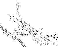
| Runways: | 12/30 |
| Longest Runway: | 12/30 is 2765 ft (843 m) long |
| Runways with an Instrument Approach: |
3U1 Airport Runway Details
| Runway 12/30 | 2765 ft x 50 ft (843 m x 15 m) | |
| Surface: | Dirt - Fair condition - No special surface treatment | |
Runway 12 |
Runway 30 |
|
Elevation: |
5869.0 | 5902.0 |
Latitude: |
45-16-14.4089N | 45-15-56.0745N |
Longitude: |
115-41-15.3323W | 115-40-46.6752W |
|
Runway True Alignment: |
132 | 312 |
Glide Path Angle: |
0.0 degrees | 0.0 degrees |
Traffic Pattern: |
Left | Left |
Object at End: |
TREES | ROAD |
Object Height: |
15 | 15 |
Distance from End: |
40 | 0 |
Object Centerline Offset: |
0 ft. left and right of centerline | 60 ft. right of centerline |
Services
Airframe Repair: |
Major |
Powerplant Repair: |
Major |
Bottled Oxygen: |
None |
Fuel Available: |
100LL, Jet A |
Landing Fees: |
No |
Parking: |
Tiedowns available |
Maps & Diagrams
3U1 Sectional
Flight Planning
at skyvector.com
at skyvector.com