Location
Latitude: |
45-40-18.4000N (45.671778) |
Longitude: |
116-18-20.6000W (-116.305722) |
Elevation: |
1660.0 feet MSL (506 m MSL) |
Magnetic Variation: |
13.3 E (as of April 2024 from WMM2020 model) |
Time Zone: |
UTC -8.0 (Standard Time) UTC -7.0 (Daylight Savings Time) |
From City: |
03 N.M. NW of Slate Creek, Idaho |
Found On: |
Great Falls Chart |
FAA Region: |
ANM |
Contacts
Manager: |
Publicly owned: |
| ID DIV OF AERONAUTICS PO BOX 7129 BOISE, ID 83707-1129 208-334-8775 |
STATE OF ID ITD, DIV OF AERONAUTICS PO BOX 7129 BOISE, ID 83707-1129 208-334-8775 |
Operations
Airport Status: |
Operational |
Facility Use: |
Public |
Type: |
Airport |
Activation Date: |
05/1951 |
Control tower: |
No |
Attendance (Months/Days/Hours): |
Months/Days/Hours Unattended |
Boundary ARTCC: |
ZSE (Seattle) |
Responsible ARTCC: |
ZSE (Seattle) |
Segmented Circle Indicator: |
Yes |
Traffic Pattern Altitude (MSL): |
2660 feet (811 m) |
NOTAMs Facility: |
BOI |
NOTAM-D Service: |
Yes |
International Airport of Entry: |
No |
Customs Landing Rights: |
No |
Civil/Military Joint Use: |
No |
Based Aircraft
Annual Operations (as of 07/30/2022)
| Total Operations: | 1050 | |
| Air Taxi: | 50 | 4.8% |
| GA Itinerant: | 1000 | 95.2% |
Communications
| CTAF: | 122.900 |
Fixed Based Operators (FBOs) & Fuel
(Click on a business for detail)
Please help us keep this information up to date. This is a FREE SERVICE just like everything else on Airport Guide! If you see that a business needs to be added, modified, or deleted please fill out our Update Form.
To add, modify, or delete a business click here.
Please help us keep this information up to date. This is a FREE SERVICE just like everything else on Airport Guide! If you see that a business needs to be added, modified, or deleted please fill out our Update Form.
Area Code: 208 |
| Business Name | Frequency | Phone | Fuel Grade |
|---|
Flight Service Stations
| Primary | Alternate | |
| FSS on Field: | N | |
| FSS Name (ID): | Boise(BOI) | |
| Frequency: | ||
| Toll Free Phone: | 1-800-WX-BRIEF |
Instrument Procedures / Charts
Terminal Procedures are only available for airports in several countries with more being added all the time. If you are looking for a specific country's charts, please send an email to support(at)airportguide.com stating the country name. This will be used to prioritize the implementation.
Navigation Aids (Navaids) near 1S7
| Dist (NM) | ID | Morse Code | Name | Type | Freq | True Hdg | Mag Hdg |
|---|---|---|---|---|---|---|---|
| 24.5 | IDQ | . . _ . . _ _ . _ | Cottonwood | DME | 115.65 | 344 | 331 |
| 48.6 | MQG | _ _ _ _ . _ _ _ . | Nez Perce | VOR-DME | 114.45 | 331 | 318 |
| 54.4 | DNJ | _ . . _ . . _ _ _ | Donnelly | VOR-DME | 116.20 | 175 | 162 |
| 71.2 | PUW | . _ _ . . . _ . _ _ | Pullman | VOR-DME | 117.15 | 327 | 313 |
| 72.4 | LGD | . _ . . _ _ . _ . . | La Grande | NDB | 296 | 254 | 241 |
| 80.7 | BKE | _ . . . _ . _ . | Baker City | VOR-DME | 115.30 | 232 | 219 |
| 84.5 | AL | . _ . _ . . | Trina | NDB | 353 | 291 | 277 |
| 86.6 | ALW | . _ . _ . . . _ _ | Walla Walla | VOR-DME | 116.40 | 287 | 273 |
Nearby Airports with Fuel
Notices to Airmen (NOTAMS)
Remarks
| A110-1 | NO LINE OF SIGHT BETWEEN RWY ENDS. |
| A110-2 | +35 FT PLINE ALONG NE BNDRY OF ARPT, CROSSES OVER TIEDOWN AREA. |
| A110-3 | RWY 12/30 YELLOW & BLACK WARNING PANELS INSTALLED ON FENCE ON BOTH RWY THRS. |
| A110-4 | NO WINTER MAINT. |
| A110-5 | NO TELEPHONE AVBL AT ARPT. |
| A110-6 | RY 12 HAS ADDL OBSTN +35 FT POLE & GUY WIRE AT 10 FT 100 FT L MARKED. |
| A110-7 | RY 12 HAS +3 FT FENCE AT 35 FT ON CNTRLN. |
| A110-8 | FOR CD CTC SEATTLE ARTCC AT 253-351-3694. |
| A42-12 | RWY 12 /30 EDGES & THLDS MARKED WITH WHITE ROCK BOUNDARY MARKERS. |
| A52-30 | +4 FT FENCE AT 25 FT ON CNTRLN MARKED. |
| E111 | ESTABD PRIOR TO 12/31/58. |
Runways
Runway Summary
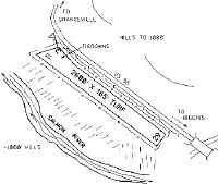
| Runways: | 12/30 |
| Longest Runway: | 12/30 is 2600 ft (792 m) long |
| Runways with an Instrument Approach: |
1S7 Airport Runway Details
| Runway 12/30 | 2600 ft x 165 ft (792 m x 50 m) | |
| Surface: | Turf - Fair condition - No special surface treatment | |
Runway 12 |
Runway 30 |
|
Latitude: |
45-40-27.3900N | 45-40-09.3700N |
Longitude: |
116-18-33.6100W | 116-18-07.5200W |
Glide Path Angle: |
0.0 degrees | 0.0 degrees |
Traffic Pattern: |
Left | Left |
Object at End: |
PLINE | PLINE |
Object Height: |
35 | 35 |
Object Marked/Lighted?: |
Marked | |
Distance from End: |
0 | 0 |
Object Centerline Offset: |
105 ft. left of centerline | 100 ft. right of centerline |
Services
Airframe Repair: |
Minor |
Powerplant Repair: |
Minor |
Bottled Oxygen: |
None |
Bulk Oxygen: |
None |
Fuel Available: |
100LL, MOGAS |
Landing Fees: |
No |
Parking: |
Hangars and tiedowns available |
Maps & Diagrams
1S7 Sectional
Flight Planning
at skyvector.com
at skyvector.com