Location
Latitude: |
43-20-37.4000N (43.343722) |
Longitude: |
072-31-02.2000W (-72.517278) |
Elevation: |
577.5 feet MSL (176 m MSL) |
Magnetic Variation: |
13.8 W (as of April 2024 from WMM2020 model) |
Time Zone: |
UTC -5.0 (Standard Time) UTC -4.0 (Daylight Savings Time) |
From City: |
03 N.M. NW of Springfield, Vermont |
Found On: |
New York Chart |
FAA Region: |
ANE |
Contacts
Manager: |
Publicly owned: |
| ROLLIN TEBBETTS 219 N MAIN ST BARRE, VT 05641 802-585-5586 |
STATE OF VERMONT 219 N MAIN ST BARRE, VT 05641 802-279-2647 |
Operations
Airport Status: |
Operational |
Facility Use: |
Public |
Type: |
Airport |
Activation Date: |
10/1937 |
Control tower: |
No |
Attendance (Months/Days/Hours): |
Months/Days/Hours JAN-DEC/SUN-SAT/0700-1800 |
Boundary ARTCC: |
ZBW (Boston) |
Responsible ARTCC: |
ZBW (Boston) |
Lighting Schedule: |
SEE RMK |
Segmented Circle Indicator: |
No |
Traffic Pattern Altitude (MSL): |
1578 feet (481 m) |
NOTAMs Facility: |
VSF |
NOTAM-D Service: |
Yes |
International Airport of Entry: |
No |
Customs Landing Rights: |
No |
Military Landing Rights: |
Yes |
Civil/Military Joint Use: |
No |
Based Aircraft
| Single Engine: | 11 |
| Multi Engine: | 1 |
| Jet Engine: | 1 |
| Gliders: | 12 |
Annual Operations (as of 12/31/2017)
| Total Operations: | 6611 | |
| Air Taxi: | 222 | 3.4% |
| GA Local: | 3752 | 56.8% |
| GA Itinerant: | 2487 | 37.6% |
| Military Aircraft: | 150 | 2.3% |
Communications
| CTAF: | 122.800 |
| Unicom: | 122.800 |
| ASOS: | 121.425 (802-886-6006) |
- COMMUNICATIONS PRVDD BY BURLINGTON RADIO ON FREQ 122.5 (SPRINGFIELD RCO).
- APCH/DEP SVC PRVDD BY BOSTON ARTCC ON FREQS 134.7/269.475 (LEBANON RCAG).
Fixed Based Operators (FBOs) & Fuel
(Click on a business for detail)
Please help us keep this information up to date. This is a FREE SERVICE just like everything else on Airport Guide! If you see that a business needs to be added, modified, or deleted please fill out our Update Form.
To add, modify, or delete a business click here.
Please help us keep this information up to date. This is a FREE SERVICE just like everything else on Airport Guide! If you see that a business needs to be added, modified, or deleted please fill out our Update Form.
Area Code: 802 |
| Business Name | Frequency | Phone | Fuel Grade |
|---|---|---|---|
| Kem Aviation
Update FBO info |
Unicom 122.8 | 886-8594 | 100LL, Jet A |
Flight Service Stations
| Primary | Alternate | |
| FSS on Field: | N | |
| FSS Name (ID): | Burlington(BTV) | |
| Frequency: | ||
| Toll Free Phone: | 1-800-WX-BRIEF |
Instrument Procedures / Charts
FAA Terminal Procedures valid from 0901Z 03/21/24 to 0901Z 04/18/24.
There are various types of charts available for an airport. They are listed in the Page Type column. Here is a legend for those types:
APD - Airport Diagram
DP - Departure Procedure Charts
HOT - Hot Spots
IAP - Instrument Approach Procedure Charts
MIN - Minimums
STAR - Standard Terminal Arrival Charts
| Page Type | Page Name | Volume | Action Since Last Cycle |
|---|---|---|---|
| IAP | LOC RWY 05 | NE-1 | |
| IAP | RNAV (GPS) RWY 05 | NE-1 | |
| MIN | ALTERNATE MINIMUMS | NE-1 | |
| MIN | TAKEOFF MINIMUMS | NE-1 |
Terminal Procedures are only available for airports in several countries with more being added all the time. If you are looking for a specific country's charts, please send an email to support(at)airportguide.com stating the country name. This will be used to prioritize the implementation.
Navigation Aids (Navaids) near VSF
| Dist (NM) | ID | Morse Code | Name | Type | Freq | True Hdg | Mag Hdg |
|---|---|---|---|---|---|---|---|
| 5.4 | SXD | . . . _ . . _ _ . . | Springfield | NDB | 265 | 214 | 228 |
| 6.6 | CNH | _ . _ . _ . . . . . | Claremont | NDB | 233 | 76 | 90 |
| 13.2 | IVV | . . . . . _ . . . _ | White River | NDB | 379 | 9 | 23 |
| 21.8 | RUT | . _ . . . _ _ | Rutland | DME | 111 | 300 | 314 |
| 24.0 | LEB | . _ . . . _ . . . | Lebanon | DME | 113.7 | 32 | 46 |
| 25.8 | R | . _ . | Chitt | FAN MARKER | 312 | 326 | |
| 26.1 | LAH | . _ . . . _ . . . . | Hanover | NDB | 276 | 34 | 48 |
| 28.9 | DYO | _ . . _ . _ _ _ _ _ | Smuto | NDB | 221 | 318 | 332 |
| 29.2 | VWD | . . . _ . _ _ _ . . | Mount Snow | NDB | 224 | 211 | 225 |
| 34.4 | EEN | . . _ . | Keene | DME | 109.4 | 163 | 177 |
| 41.8 | CON | _ . _ . _ _ _ _ . | Concord | VOR-DME | 112.90 | 99 | 113 |
| 41.8 | CAM | _ . _ . . _ _ _ | Cambridge | VOR-DME | 115.00 | 240 | 254 |
| 44.2 | LC | . _ . . _ . _ . | Blnap | NDB | 328 | 74 | 88 |
| 44.6 | MPV | _ _ . _ _ . . . . _ | Montpelier | VOR-DME | 116.90 | 3 | 17 |
| 47.6 | ORE | _ _ _ . _ . . | Orange | NDB | 205 | 167 | 181 |
| 47.8 | GFL | _ _ . . . _ . . _ . . | Glens Falls | VORTAC | 110.20 | 270 | 284 |
| 47.8 | GF | _ _ . . . _ . | Ganse | NDB | 209 | 263 | 277 |
| 48.5 | CO | _ . _ . _ _ _ | Epsom | NDB | 216 | 105 | 119 |
| 48.8 | LCI | . _ . . _ . _ . . . | Laconia | FAN MARKER | 73 | 87 | |
| 50.8 | AS | . _ . . . | Chern | NDB | 359 | 127 | 141 |
Nearby Airports with Fuel
Notices to Airmen (NOTAMS)
Remarks
| A110-1 | CFR NOT AVBL ON ARPT. |
| A110-10 | FOR CD IF UNA TO CTC ON FSS FREQ, CTC BOSTON ARTCC AT 603-879-6859 . |
| A110-2 | RWY CONDS MAY NOT BE MNT OR RPRTD WHEN ARPT IS UNATNDD. |
| A110-3 | (E143) LOC ONLY |
| A110-4 | GEESE ON & INVOF ARPT. |
| A110-5 | APRON & TWYS A & B PAVEMENT CAPACITY IS S-46 & D-62. |
| A110-6 | NOISE SENSITIVE AREA WEST OF ARPT. |
| A110-7 | RWY 23 IS PREFERRED FOR DAY, VFR, NO WIND CONDS. |
| A110-8 | MNTN RCMDD PAT ALT ON DOWNWIND LEG FOR RWY 05. |
| A110-9 | COLD TEMPERATURE AIRPORT. ALTITUDE CORRECTION REQUIRED AT OR BELOW -20C. |
| A58-05 | RWY 05, +35 FT TREES, 0-200 FT FM END OF RWY, 250 FT LEFT OF CNTRLN. |
| A58-11 | RWY 11, +40 FT TREES, 0-400 FT FM END OF RWY CNTRLN. |
| A58-23 | RWY 23, 1-20 FT TREES, 0-200 FT FM END OF RWY, 175-250 FT LEFT OF CNTRLN. |
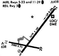
| A81-APT | ACTVT REIL RWY 05; MIRL RWY 05/23 & 11/29 - CTAF. |
| A94 | GLDRS ON & INVOF ARPT. |
| E111 | EXISTED PRIOR TO 1959. |
| E147 | 1100 FT AGL SNGL ENG; 1600 FT AGL MULT ENG. |
Runways
Runway Summary
| Runways: | 05/23 11/29 |
| Longest Runway: | 05/23 is 5501 ft (1677 m) long |
| Runways with an Instrument Approach: | 05 |
VSF Airport Runway Details
| Runway 05/23 | 5501 ft x 100 ft (1677 m x 30 m) | |
| Runway Length Source: | 3RD PARTY SURVEY as of 06/27/2010 | |
| Surface: | Asphalt - Fair condition - No special surface treatment | |
| Runway Edge Lights: | Medium Intensity | |
Runway Weight Bearing Capacity (in thousands of pounds) |
||
| Single Wheel Landing Gear: | 32.0 | |
| Dual Wheel Landing Gear: | 45.0 | |
Runway 05 |
Runway 23 |
|
Elevation: |
570.9 | 554.2 |
Latitude: |
43-20-20.1039N | 43-21-04.7987N |
Longitude: |
072-31-16.5741W | 072-30-34.2521W |
|
Runway True Alignment: |
035 | 215 |
ILS Type: |
LOC/DME | |
Glide Path Angle: |
4.0 degrees | 0.0 degrees |
Traffic Pattern: |
Left | Left |
Runway Markings Type: |
Nonprecision Instrument | Nonprecision Instrument |
Runway Markings Condition: |
Fair | Fair |
Object at End: |
TREES | TREES |
Object Height: |
30 | 27 |
Distance from End: |
383 | 491 |
Object Centerline Offset: |
120 ft. left of centerline | 27 ft. right of centerline |
Visual Glide Slope Indicators: |
4-Box VASI On Left Side Of Runway | |
REIL: |
Yes | No |
Touchdown Lights: |
No | No |
Centerline Lights: |
No | No |
Threshold Crossing Height: |
59 |
| Runway 11/29 | 3000 ft x 75 ft (914 m x 23 m) | |
| Runway Length Source: | 3RD PARTY SURVEY as of 06/27/2010 | |
| Surface: | Asphalt - Fair condition - No special surface treatment | |
| Runway Edge Lights: | Medium Intensity | |
Runway Weight Bearing Capacity (in thousands of pounds) |
||
| Single Wheel Landing Gear: | 30.0 | |
Runway 11 |
Runway 29 |
|
Elevation: |
575.9 | 568.8 |
Latitude: |
43-20-30.2285N | 43-20-25.7817N |
Longitude: |
072-31-34.8224W | 072-30-54.6864W |
|
Runway True Alignment: |
099 | 279 |
Glide Path Angle: |
0.0 degrees | 0.0 degrees |
Traffic Pattern: |
Left | Left |
Runway Markings Type: |
Basic | Basic |
Runway Markings Condition: |
Fair | Fair |
Object at End: |
TREES | |
Object Height: |
61 | |
Distance from End: |
457 | |
Object Centerline Offset: |
120 ft. left of centerline | 27 ft. right of centerline |
REIL: |
No | No |
Touchdown Lights: |
No | No |
Centerline Lights: |
No | No |
Services
Airframe Repair: |
Major |
Powerplant Repair: |
Major |
Bottled Oxygen: |
None |
Bulk Oxygen: |
None |
Fuel Available: |
100LL, Jet A, Jet A+ |
Landing Fees: |
Yes |
Parking: |
Hangars and tiedowns available |
Maps & Diagrams
VSF Sectional
Flight Planning
at skyvector.com
at skyvector.com