Location
Latitude: |
39-29-16.1000N (39.487806) |
Longitude: |
121-37-19.2000W (-121.622) |
Elevation: |
194.3 feet MSL (59 m MSL) |
Magnetic Variation: |
13.3 E (as of April 2024 from WMM2020 model) |
Time Zone: |
UTC -8.0 (Standard Time) UTC -7.0 (Daylight Savings Time) |
From City: |
03 N.M. SW of Oroville, California |
Found On: |
San Francisco Chart |
FAA Region: |
AWP |
Contacts
Manager: |
Publicly owned: |
| CODY NISSEN 1735 MONTGOMERY ST. OROVILLE, CA 95965 530-538-2490 |
CITY OF OROVILLE 1735 MONTGOMERY ST OROVILLE, CA 95965 530-538-2405 |
Operations
Airport Status: |
Operational |
Facility Use: |
Public |
Type: |
Airport |
Activation Date: |
04/1940 |
Control tower: |
No |
Attendance (Months/Days/Hours): |
Months/Days/Hours ALL/MON-SAT/0800-1700 |
Boundary ARTCC: |
ZOA (Oakland) |
Responsible ARTCC: |
ZOA (Oakland) |
Lighting Schedule: |
SEE RMK |
Segmented Circle Indicator: |
Yes |
Traffic Pattern Altitude (MSL): |
1194 feet (364 m) |
NOTAMs Facility: |
OVE |
NOTAM-D Service: |
Yes |
International Airport of Entry: |
No |
Customs Landing Rights: |
No |
Military Landing Rights: |
Yes |
Civil/Military Joint Use: |
No |
Based Aircraft
| Single Engine: | 41 |
| GA Helicopters: | 1 |
| Gliders: | 1 |
| Ultralights: | 2 |
Annual Operations (as of 12/31/2022)
| Total Operations: | 36000 | |
| Air Taxi: | 1500 | 4.2% |
| GA Local: | 14500 | 40.3% |
| GA Itinerant: | 20000 | 55.6% |
Communications
| CTAF: | 122.800 |
| Unicom: | 122.800 |
| Approach: | NORCAL 125.4 125.4 |
| Departure: | NORCAL 125.4 125.4 |
| ASOS: | 121.425 (530-533-5792) |
Fixed Based Operators (FBOs) & Fuel
(Click on a business for detail)
Please help us keep this information up to date. This is a FREE SERVICE just like everything else on Airport Guide! If you see that a business needs to be added, modified, or deleted please fill out our Update Form.
To add, modify, or delete a business click here.
Please help us keep this information up to date. This is a FREE SERVICE just like everything else on Airport Guide! If you see that a business needs to be added, modified, or deleted please fill out our Update Form.
Area Code: 530 |
| Business Name | Frequency | Phone | Fuel Grade |
|---|---|---|---|
| Table Mountain Aviation
Update FBO info |
CTAF 122.8 | 530-533-1313 | 80, 100LL, Jet A |
Flight Service Stations
| Primary | Alternate | |
| FSS on Field: | N | |
| FSS Name (ID): | Rancho Murieta(RIU) | |
| Frequency: | ||
| Toll Free Phone: | 1-800-WX-BRIEF |
Instrument Procedures / Charts
FAA Terminal Procedures valid from 0901Z 03/21/24 to 0901Z 04/18/24.
There are various types of charts available for an airport. They are listed in the Page Type column. Here is a legend for those types:
APD - Airport Diagram
DP - Departure Procedure Charts
HOT - Hot Spots
IAP - Instrument Approach Procedure Charts
MIN - Minimums
STAR - Standard Terminal Arrival Charts
| Page Type | Page Name | Volume | Action Since Last Cycle |
|---|---|---|---|
| IAP | RNAV (GPS) RWY 02 | SW-2 | |
| IAP | VOR-A | SW-2 | |
| MIN | TAKEOFF MINIMUMS | SW-2 |
Terminal Procedures are only available for airports in several countries with more being added all the time. If you are looking for a specific country's charts, please send an email to support(at)airportguide.com stating the country name. This will be used to prioritize the implementation.
Navigation Aids (Navaids) near OVE
| Dist (NM) | ID | Morse Code | Name | Type | Freq | True Hdg | Mag Hdg |
|---|---|---|---|---|---|---|---|
| 19.1 | MY | _ _ _ . _ _ | Halow | NDB | 222 | 178 | 165 |
| 20.9 | CIC | _ . _ . . . _ . _ . | Chico | VOR-DME | 109.80 | 330 | 317 |
| 22.8 | BAB | _ . . . . _ _ . . . | Beale | TACAN | 108.60 | 158 | 145 |
| 23.5 | MYV | _ _ _ . _ _ . . . _ | Marysville | VOR-DME | 110.80 | 174 | 161 |
| 29.6 | MXW | _ _ _ . . _ . _ _ | Maxwell | VORTAC | 110.00 | 250 | 237 |
| 31.3 | ILA | . . . _ . . . _ | Williams | VORTAC | 114.40 | 217 | 204 |
| 46.3 | RBL | . _ . _ . . . . _ . . | Red Bluff | VORTAC | 115.70 | 322 | 309 |
| 47.1 | PBT | . _ _ . _ . . . _ | Proberta | NDB | 338 | 323 | 310 |
| 47.8 | SMF | . . . _ _ . . _ . | Sacramento Intl | VOT | 111.40 | 178 | 165 |
| 50.3 | MCC | _ _ _ . _ . _ . _ . | Mc Clellan | VOR-DME | 109.20 | 168 | 155 |
| 59.0 | SAC | . . . . _ _ . _ . | Sacramento Executive | VOT | 111.40 | 174 | 161 |
| 61.2 | HNW | . . . . _ . . _ _ | Hangtown | VOR-DME | 115.50 | 138 | 125 |
| 62.7 | SAC | . . . . _ _ . _ . | Sacramento | VORTAC | 115.20 | 176 | 163 |
| 65.4 | SWR | . . . . _ _ . _ . | Squaw Valley | VOR-DME | 113.20 | 105 | 92 |
| 68.3 | RDD | . _ . _ . . _ . . | Redding | VOR-DME | 114.35 | 333 | 320 |
| 69.2 | TZZ | _ _ _ . . _ _ . . | Travis | VOR | 116.40 | 187 | 174 |
| 76.0 | SUU | . . . . . _ . . _ | Travis | TACAN | 116.60 | 191 | 178 |
| 76.1 | UK | . . _ _ . _ | Kearn | NDB | 371 | 260 | 247 |
| 80.8 | STS | . . . _ . . . | Santa Rosa | DME | 116.15 | 223 | 210 |
| 81.1 | ENI | . _ . . . | Mendocino | VORTAC | 112.30 | 251 | 238 |
Nearby Airports with Fuel
Notices to Airmen (NOTAMS)
Remarks
| A110-1 | TWY FROM RY 02/20 TO GOLF COURSE/RESTAURANT TIEDOWNS 20 FT WIDE WITH NO SHOULDERS. |
| A110-2 | FIREFIGHTING ACFT INVOF ARPT MAY-OCT. |
| A110-3 | FOR ARPT INFO MON-FRI CTC (530) 538-2420. |
| A110-5 | FOR CD CTC NORCAL APCH AT 916-361-6874. |
| A43-20 | DOES NOT PRVD OBSTN CLNC BYD 3 NM. |
| A81-APT | ACTVT REIL RWY 02 & 20; PAPI RWY 02, 13, 20 & 31; HIRL RWY 02/20 & RWY 13/31 - CTAF. |
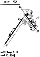
Runways
Runway Summary
| Runways: | 02/20 13/31 |
| Longest Runway: | 02/20 is 6020 ft (1835 m) long |
| Runways with an Instrument Approach: |
OVE Airport Runway Details
| Runway 02/20 | 6020 ft x 100 ft (1835 m x 30 m) | |
| Runway Length Source: | 3RD PARTY SURVEY as of 08/05/2012 | |
| Surface: | Asphalt - Good condition - No special surface treatment | |
| Runway Edge Lights: | High Intensity | |
Runway Weight Bearing Capacity (in thousands of pounds) |
||
| Single Wheel Landing Gear: | 47.0 | |
| Dual Wheel Landing Gear: | 90.0 | |
Runway 02 |
Runway 20 |
|
Elevation: |
181.5 | 184.6 |
Latitude: |
39-28-43.8564N | 39-29-33.7674N |
Longitude: |
121-37-54.5111W | 121-37-12.7193W |
|
Runway True Alignment: |
033 | 213 |
Glide Path Angle: |
3.0 degrees | 3.0 degrees |
Traffic Pattern: |
Left | Left |
Runway Markings Type: |
Nonprecision Instrument | Nonprecision Instrument |
Runway Markings Condition: |
Good | Good |
Visual Glide Slope Indicators: |
2-Light PAPI On Left Side Of Runway | 2-Light PAPI On Left Side Of Runway |
REIL: |
Yes | Yes |
Touchdown Lights: |
No | No |
Centerline Lights: |
No | No |
Threshold Crossing Height: |
44 | 40 |
| Runway 13/31 | 3540 ft x 100 ft (1079 m x 30 m) | |
| Runway Length Source: | 3RD PARTY SURVEY as of 08/05/2012 | |
| Surface: | Asphalt - Good condition - No special surface treatment | |
| Runway Edge Lights: | High Intensity | |
Runway Weight Bearing Capacity (in thousands of pounds) |
||
| Single Wheel Landing Gear: | 19.0 | |
| Dual Wheel Landing Gear: | 31.0 | |
Runway 13 |
Runway 31 |
|
Elevation: |
192.8 | 176.9 |
Latitude: |
39-29-42.7380N | 39-29-14.5213N |
Longitude: |
121-37-07.9036W | 121-36-41.2177W |
|
Runway True Alignment: |
144 | 324 |
Glide Path Angle: |
3.0 degrees | 3.0 degrees |
Traffic Pattern: |
Left | Left |
Runway Markings Type: |
Basic | Basic |
Runway Markings Condition: |
Good | Good |
Object at End: |
TREES | |
Object Height: |
20 | |
Distance from End: |
600 | |
Visual Glide Slope Indicators: |
2-Light PAPI On Left Side Of Runway | 2-Light PAPI On Left Side Of Runway |
REIL: |
No | No |
Touchdown Lights: |
No | No |
Centerline Lights: |
No | No |
Threshold Crossing Height: |
39 | 29 |
Services
Airframe Repair: |
Major |
Powerplant Repair: |
Major |
Bottled Oxygen: |
High Pressure / Low Pressure |
Bulk Oxygen: |
High Pressure / Low Pressure |
Fuel Available: |
100LL, Jet A, Jet A+ |
Landing Fees: |
No |
Parking: |
Tiedowns available |
Other Services: |
Skydiving instruction |
Maps & Diagrams
OVE Sectional
Flight Planning
at skyvector.com
at skyvector.com