Location
Latitude: |
30-27-45.9790N (30.462772) |
Longitude: |
088-31-45.2230W (-88.529229) |
Elevation: |
16.8 feet MSL (5 m MSL) |
Magnetic Variation: |
2.5 W (as of April 2024 from WMM2020 model) |
Time Zone: |
UTC -6.0 (Standard Time) UTC -5.0 (Daylight Savings Time) |
From City: |
06 N.M. N of Pascagoula, Mississippi |
Found On: |
New Orleans Chart |
FAA Region: |
ASO |
Contacts
Manager: |
Publicly owned: |
| CINNAMON SNYDER 8301 SARACENNIA RD, STE 11 MOSS POINT, MS 39563-9478 228-475-1371 |
JACKSON COUNTY 8301 SARACENNIA RD MOSS POINT, MS 39563-9478 228-769-3089 |
Operations
Airport Status: |
Operational |
Facility Use: |
Public |
Type: |
Airport |
Activation Date: |
10/1990 |
Control tower: |
Yes |
Attendance (Months/Days/Hours): |
Months/Days/Hours ALL/ALL/ALL |
Boundary ARTCC: |
ZHU (Houston) |
Responsible ARTCC: |
ZHU (Houston) |
Lighting Schedule: |
SEE RMK |
Segmented Circle Indicator: |
Yes |
Traffic Pattern Altitude (MSL): |
1017 feet (310 m) |
NOTAMs Facility: |
PQL |
NOTAM-D Service: |
Yes |
Customs Landing Rights: |
Yes |
Military Landing Rights: |
Yes |
Civil/Military Joint Use: |
No |
Based Aircraft
| Single Engine: | 24 |
| Multi Engine: | 4 |
| Jet Engine: | 2 |
| GA Helicopters: | 2 |
Annual Operations (as of 05/26/2023)
| Total Operations: | 32787 | |
| Air Taxi: | 3189 | 9.7% |
| GA Local: | 16758 | 51.1% |
| GA Itinerant: | 11606 | 35.4% |
| Military Aircraft: | 1234 | 3.8% |
Communications
| CTAF: | 118.575 |
| Unicom: | 122.800 |
| Tower: | TRENT LOTT 118.575 Hrs: MON-FRI 0600-2000; SAT-SUN 0800-1800. |
| Clearance Del.: | 121.725 |
| Ground: | 121.725 |
| Approach: | MOBILE 121.0 121.0 HOUSTON ARTCC |
| Departure: | MOBILE 121.0 121.0 HOUSTON ARTCC |
| ATIS: | 135.175 Hrs: 24 |
| ASOS: | 135.175 (228-474-2836) |
- APCH/DEP SVC PRVDD BY HOUSTON ARTCC (ZHU) ON FREQS 127.65/285.475 (MOBILE RCAG) WHEN MOBILE APCH CTL (MOB) CLSD.
Fixed Based Operators (FBOs) & Fuel
(Click on a business for detail)
Please help us keep this information up to date. This is a FREE SERVICE just like everything else on Airport Guide! If you see that a business needs to be added, modified, or deleted please fill out our Update Form.
To add, modify, or delete a business click here.
Please help us keep this information up to date. This is a FREE SERVICE just like everything else on Airport Guide! If you see that a business needs to be added, modified, or deleted please fill out our Update Form.
Area Code: 228 |
| Business Name | Frequency | Phone | Fuel Grade |
|---|---|---|---|
| Aero Marine Service
Update FBO info |
Unicom 122.8 | 474-2784 |
Flight Service Stations
| Primary | Alternate | |
| FSS on Field: | ||
| FSS Name (ID): | Greenwood(GWO) | |
| Frequency: | ||
| Toll Free Phone: | 1-800-WX-BRIEF |
Instrument Procedures / Charts
FAA Terminal Procedures valid from 0901Z 03/21/24 to 0901Z 04/18/24.
There are various types of charts available for an airport. They are listed in the Page Type column. Here is a legend for those types:
APD - Airport Diagram
DP - Departure Procedure Charts
HOT - Hot Spots
IAP - Instrument Approach Procedure Charts
MIN - Minimums
STAR - Standard Terminal Arrival Charts
| Page Type | Page Name | Volume | Action Since Last Cycle |
|---|---|---|---|
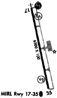
| APD | AIRPORT DIAGRAM | SC-4 | |
| IAP | ILS OR LOC RWY 17 | SC-4 | |
| IAP | RNAV (GPS) RWY 17 | SC-4 | |
| IAP | RNAV (GPS) RWY 35 | SC-4 | |
| MIN | ALTERNATE MINIMUMS | SC-4 | |
| MIN | TAKEOFF MINIMUMS | SC-4 |
Terminal Procedures are only available for airports in several countries with more being added all the time. If you are looking for a specific country's charts, please send an email to support(at)airportguide.com stating the country name. This will be used to prioritize the implementation.
Navigation Aids (Navaids) near PGL
| Dist (NM) | ID | Morse Code | Name | Type | Freq | True Hdg | Mag Hdg |
|---|---|---|---|---|---|---|---|
| 18.1 | SJI | . . . . _ _ _ . . | Semmes | VORTAC | 115.30 | 29 | 32 |
| 21.0 | BIX | _ . . . . . _ . . _ | Keesler | TACAN | 111.80 | 260 | 262 |
| 21.3 | MOB | _ _ _ _ _ _ . . . | Wisle | NDB | 248 | 33 | 36 |
| 26.1 | BFM | _ . . . . . _ . _ _ | Brookley | VORTAC | 116.35 | 69 | 72 |
| 28.5 | GPT | _ _ . . _ _ . _ | Gulfport | VORTAC | 109.00 | 263 | 265 |
| 32.8 | GP | _ _ . . _ _ . | Bayou | NDB | 360 | 272 | 274 |
| 38.2 | GCV | _ _ . _ . _ . . . . _ | Greene County | VORTAC | 115.70 | 3 | 6 |
| 41.6 | ESU | . . . . . . _ | Summerdale | NDB | 204 | 86 | 89 |
| 47.9 | HS | . . . . . . . | Hanco | NDB | 221 | 269 | 271 |
| 61.7 | NUN | _ . . . _ _ . | Saufley | VOR | 112.25 | 89 | 92 |
| 62.4 | PCU | . _ _ . _ . _ . . . _ | Picayune | VOR-DME | 113.95 | 275 | 277 |
| 63.1 | NPA | _ . . _ _ . . _ | Pensacola | TACAN | 117.20 | 95 | 98 |
| 69.9 | PKZ | . _ _ . _ . _ _ _ . . | Pickens | NDB | 326 | 90 | 93 |
| 70.9 | LBY | . _ . . _ . . . _ . _ _ | Eaton | VORTAC | 110.60 | 324 | 326 |
| 73.2 | GVB | _ _ . . . . _ _ . . . | Bogalusa | NDB | 353 | 290 | 292 |
| 79.6 | NSE | _ . . . . . | Whiting | TACAN | 112.30 | 78 | 81 |
| 80.9 | THJ | _ . . . . . _ _ _ | Tallahala | NDB | 346 | 335 | 337 |
| 82.8 | NGS | _ . _ _ . . . . | Santa Rosa | TACAN | 133.60 | 83 | 86 |
| 84.8 | HRV | . . . . . _ . . . . _ | Harvey | VORTAC | 114.10 | 244 | 246 |
| 85.1 | MVC | _ _ . . . _ _ . _ . | Monroeville | VORTAC | 116.80 | 45 | 48 |
Nearby Airports with Fuel
Notices to Airmen (NOTAMS)
Remarks
| A11 | PAUL WILSON, JCAA CHAIRMAN. |
| A110-3 | NMRS LOW FLYING FISH SPOTTER ACFT OPRG NEAR SHORELINE BTN BAY ST LOUIS & PASCAGOULA SR-SS. |
| A110-5 | ARFF 24 HRS. |
| A110-6 | FOR CD WHEN ATCT CLSD CTC MOBILE APCH AT 251-662-6236, WHEN APCH CLSD CTC HOUSTON ARTCC AT 281-230-5622. |
| A16 | IFUN TO CTC AMGR CALL FBO: 228-474-1000. |
| A35-17/35 | UNL. |
| A70-FUEL-10 | 0LL MIL CONTR FUEL AVBL. |
| A81-APT | ACTVT MALSR RWY 17; PAPI RWY 35; MIRL RWY 17/35 - CTAF. |
| E111 | PRVDD ALL OPS IN VFR CONDS. |
Runways
Runway Summary
| Runways: | 17/35 |
| Longest Runway: | 17/35 is 6501 ft (1982 m) long |
| Runways with an Instrument Approach: | 17 |
PGL Airport Runway Details
| Runway 17/35 | 6501 ft x 150 ft (1982 m x 46 m) | |
| Runway Length Source: | 3RD PARTY SURVEY as of 03/18/2022 | |
| Surface: | Asphalt - Excellent condition - Saw-cut or plastic grooved | |
| Runway Pavement Class: | 57 /F/C/X/T | |
| Runway Edge Lights: | Medium Intensity | |
Runway Weight Bearing Capacity (in thousands of pounds) |
||
| Dual Wheel Landing Gear: | 196.0 | |
| Dual Tandem Wheel Landing Gear: | 315.0 | |
| Dual Dual Tandem Wheel Landing Gear: | 753.0 | |
Runway 17 |
Runway 35 |
|
Elevation: |
15.8 | 16.7 |
Latitude: |
30-28-17.2053N | 30-27-14.7531N |
Longitude: |
088-31-54.1786W | 088-31-36.2689W |
|
Runway True Alignment: |
166 | 346 |
ILS Type: |
ILS/DME | |
Glide Path Angle: |
3.0 degrees | 3.0 degrees |
Runway Markings Type: |
Precision Instrument | Nonprecision Instrument |
Runway Markings Condition: |
Good | Fair |
Visual Glide Slope Indicators: |
4-Light PAPI On Left Side Of Runway | 4-Light PAPI On Left Side Of Runway |
Approach Light System: |
1,400 Foot Medium Intensity Approach Lighting System With Runway Alignment Indicator Lights | |
Threshold Crossing Height: |
50 | 40 |
Services
Airframe Repair: |
Minor |
Powerplant Repair: |
Minor |
Bottled Oxygen: |
None |
Bulk Oxygen: |
None |
Fuel Available: |
100LL, Jet A-1+ |
Landing Fees: |
No |
Parking: |
Hangars and tiedowns available |
Maps & Diagrams
PGL Sectional
Flight Planning
at skyvector.com
at skyvector.com