Location
Latitude: |
34-24-44.9260N (34.412479) |
Longitude: |
091-27-55.1000W (-91.465306) |
Elevation: |
210.2 feet MSL (64 m MSL) |
Magnetic Variation: |
0.8 W (as of April 2024 from WMM2020 model) |
Time Zone: |
UTC -6.0 (Standard Time) UTC -5.0 (Daylight Savings Time) |
From City: |
03 N.M. W of Almyra, Arkansas |
Found On: |
Memphis Chart |
FAA Region: |
ASW |
Contacts
Manager: |
Publicly owned: |
| MARK HARTZ 275 ALMYRA AIRPORT ROAD ALMYRA, AR 72003 (870) 830-1231 |
CITY OF ALMYRA P O BOX 213 ALMYRA, AR 72003 870-673-1591 |
Operations
Airport Status: |
Operational |
Facility Use: |
Public |
Type: |
Airport |
Control tower: |
No |
Attendance (Months/Days/Hours): |
Months/Days/Hours ALL/MON-FRI/0800-1700 |
Boundary ARTCC: |
ZME (Memphis) |
Responsible ARTCC: |
ZME (Memphis) |
Lighting Schedule: |
SEE RMK |
Segmented Circle Indicator: |
Yes |
Traffic Pattern Altitude (MSL): |
1210 feet (369 m) |
NOTAMs Facility: |
JBR |
NOTAM-D Service: |
Yes |
International Airport of Entry: |
No |
Customs Landing Rights: |
No |
Military Landing Rights: |
Yes |
Civil/Military Joint Use: |
No |
Based Aircraft
| Single Engine: | 11 |
Annual Operations (as of 12/31/2022)
| Total Operations: | 54100 | |
| GA Local: | 50000 | 92.4% |
| GA Itinerant: | 4000 | 7.4% |
| Military Aircraft: | 100 | 0.2% |
Communications
| CTAF: | 123.000 |
| Unicom: | 123.000 |
| Approach: | LITTLE ROCK 119.85 119.85 119.85 |
| Departure: | LITTLE ROCK 119.85 119.85 119.85 |
Fixed Based Operators (FBOs) & Fuel
(Click on a business for detail)
Please help us keep this information up to date. This is a FREE SERVICE just like everything else on Airport Guide! If you see that a business needs to be added, modified, or deleted please fill out our Update Form.
To add, modify, or delete a business click here.
Please help us keep this information up to date. This is a FREE SERVICE just like everything else on Airport Guide! If you see that a business needs to be added, modified, or deleted please fill out our Update Form.
Area Code: 501 |
| Business Name | Frequency | Phone | Fuel Grade |
|---|---|---|---|
| Grand Prairie Dusters, Inc.
Update FBO info |
Unicom 123.0 | 992-3333, -3386 | 100LL |
Flight Service Stations
| Primary | Alternate | |
| FSS on Field: | N | |
| FSS Name (ID): | Jonesboro(JBR) | |
| Frequency: | ||
| Toll Free Phone: | 1-800-WX-BRIEF |
Instrument Procedures / Charts
FAA Terminal Procedures valid from 0901Z 03/21/24 to 0901Z 04/18/24.
There are various types of charts available for an airport. They are listed in the Page Type column. Here is a legend for those types:
APD - Airport Diagram
DP - Departure Procedure Charts
HOT - Hot Spots
IAP - Instrument Approach Procedure Charts
MIN - Minimums
STAR - Standard Terminal Arrival Charts
| Page Type | Page Name | Volume | Action Since Last Cycle |
|---|---|---|---|
| IAP | RNAV (GPS) RWY 36 | SC-1 | |
| MIN | TAKEOFF MINIMUMS | SC-1 |
Terminal Procedures are only available for airports in several countries with more being added all the time. If you are looking for a specific country's charts, please send an email to support(at)airportguide.com stating the country name. This will be used to prioritize the implementation.
Navigation Aids (Navaids) near M73
| Dist (NM) | ID | Morse Code | Name | Type | Freq | True Hdg | Mag Hdg |
|---|---|---|---|---|---|---|---|
| 8.0 | TT | _ _ | Stutt | NDB | 338 | 314 | 315 |
| 16.3 | SGT | . . . _ _ . _ | Stuttgart | NDB | 269 | 337 | 338 |
| 24.9 | PBF | . _ _ . _ . . . . . _ . | Pine Bluff | VOR-DME | 116.00 | 246 | 247 |
| 38.8 | LIT | . _ . . . . _ | Little Rock | VORTAC | 113.90 | 294 | 295 |
| 40.3 | UJM | . . _ . _ _ _ _ _ | Marvell | VOR-DME | 109.60 | 75 | 76 |
| 42.4 | TYV | _ _ . _ _ . . . _ | Toneyville | NDB | 290 | 319 | 320 |
| 44.3 | LI | . _ . . . . | Lasky | NDB | 353 | 290 | 291 |
| 45.0 | DS | _ . . . . . | Cercy | NDB | 375 | 341 | 342 |
| 45.7 | LRF | . _ . . . _ . . . _ . | Jacksonville | TACAN | 109.20 | 311 | 312 |
| 52.5 | MON | _ _ _ _ _ _ . | Monticello | DME | 111.6 | 193 | 194 |
| 58.5 | GLH | _ _ . . _ . . . . . . | Greenville | VOR-DME | 114.25 | 155 | 156 |
| 62.2 | CWS | _ . _ . . _ _ . . . | Conway | NDB | 302 | 310 | 311 |
| 63.9 | MTQ | _ _ _ _ _ . _ | Metcalf | NDB | 359 | 157 | 158 |
| 74.2 | GQE | _ _ . _ _ . _ . | Gilmore | VOR-DME | 113.00 | 40 | 41 |
| 79.0 | ME | _ _ . | Elvis | NDB | 287 | 60 | 61 |
| 79.1 | BV | _ . . . . . . _ | Almnd | NDB | 335 | 348 | 349 |
| 80.5 | HOT | . . . . _ _ _ _ | Hot Springs | VOR-DME | 110.00 | 273 | 273 |
| 81.6 | MEM | _ _ . _ _ | Memphis | VORTAC | 117.50 | 63 | 64 |
| 82.1 | SQS | . . . _ _ . _ . . . | Sidon | VORTAC | 114.70 | 133 | 134 |
| 82.6 | MEM | _ _ . _ _ | Memphis Metropolitn | VOT | 111.00 | 61 | 62 |
Nearby Airports with Fuel
Notices to Airmen (NOTAMS)
Remarks
| A110-1 | MIGRATORY BIRDS ON & INVOF AIRPORT NOV-FEB |
| A110-2 | NUMEROUS AGRICULTURAL ACFT OPNS |
| A110-3 | FOR CD WHEN UNA VIA FREQ CTC LITTLE ROCK APCH 501-379-2908 OR LITTLE ROCK ATCT 501-379-2911 |
| A42-18 | RWY 18 MARKINGS FADED |
| A57-18 | RWY 18 APCH RATIO FROM DSPLCD THLD 32:1 |
| A58-10 | 10 FT GRVL ROAD 0 FT FM THLD. |
| A70-FUEL-10 | 0LL 100 LL SELF SERVE AVBL WITH CREDIT CARD. FOR SVC AFT HRS CALL 870-830-1231. |
| A81-APT | ACTVT MIRL RY 18/36, PAPI RYS 18 & 36 - CTAF. |
| E111 | PRE DATES THE ACT. |
Runways
Runway Summary
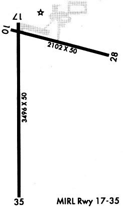
| Runways: | 10/28 18/36 |
| Longest Runway: | 18/36 is 3494 ft (1065 m) long |
| Runways with an Instrument Approach: |
M73 Airport Runway Details
| Runway 10/28 | 3000 ft x 50 ft (914 m x 15 m) | |
| Runway Length Source: | 3RD PARTY SURVEY as of 04/19/2019 | |
| Surface: | Asphalt - Fair condition - No special surface treatment | |
Runway Weight Bearing Capacity (in thousands of pounds) |
||
| Single Wheel Landing Gear: | 4.0 | |
Runway 10 |
Runway 28 |
|
Elevation: |
208.9 | 204.1 |
Latitude: |
34-24-55.6076N | 34-24-47.6171N |
Longitude: |
091-28-03.1560W | 091-27-28.6719W |
|
Runway True Alignment: |
106 | 286 |
Glide Path Angle: |
0.0 degrees | 0.0 degrees |
Traffic Pattern: |
Left | Left |
Runway Markings Type: |
Basic | Basic |
Runway Markings Condition: |
Fair | Fair |
Object at End: |
TREES | |
Object Height: |
20 | |
Distance from End: |
540 | |
Object Centerline Offset: |
115 ft. right of centerline |
| Runway 18/36 | 3494 ft x 60 ft (1065 m x 18 m) | |
| Runway Length Source: | 3RD PARTY SURVEY as of 04/19/2019 | |
| Surface: | Asphalt - Fair condition - No special surface treatment | |
| Runway Edge Lights: | Medium Intensity | |
Runway Weight Bearing Capacity (in thousands of pounds) |
||
| Single Wheel Landing Gear: | 4.0 | |
Runway 18 |
Runway 36 |
|
Elevation: |
208.8 | 203.1 |
Latitude: |
34-24-56.4665N | 34-24-21.9048N |
Longitude: |
091-28-02.7884W | 091-28-03.1866W |
|
Runway True Alignment: |
181 | 001 |
Glide Path Angle: |
3.0 degrees | 3.0 degrees |
Traffic Pattern: |
Left | Left |
Runway Markings Type: |
Basic | Nonprecision Instrument |
Runway Markings Condition: |
Poor | Fair |
Object at End: |
ROAD | |
Object Height: |
15 | |
Distance from End: |
450 | |
Object Centerline Offset: |
115 ft. right of centerline | |
Visual Glide Slope Indicators: |
2-Light PAPI On Right Side Of Runway | 2-Light PAPI On Left Side Of Runway |
Threshold Crossing Height: |
39 | 37 |
Threshold Elevation: |
209.0 | |
Displaced Threshold: |
38 | |
Threshold Latitude: |
34-24-56.0916N | |
Threshold Longitude: |
091-28-02.7927W |
Services
Airframe Repair: |
None |
Powerplant Repair: |
None |
Bottled Oxygen: |
None |
Bulk Oxygen: |
None |
Fuel Available: |
100LL, Jet A |
Landing Fees: |
No |
Parking: |
Tiedowns available |
Maps & Diagrams
M73 Sectional
Flight Planning
at skyvector.com
at skyvector.com