Location
Latitude: |
35-30-42.0980N (35.511694) |
Longitude: |
092-00-46.8340W (-92.013009) |
Elevation: |
632.3 feet MSL (193 m MSL) |
Magnetic Variation: |
0.5 W (as of April 2024 from WMM2020 model) |
Time Zone: |
UTC -6.0 (Standard Time) UTC -5.0 (Daylight Savings Time) |
From City: |
02 N.M. NE of Heber Springs, Arkansas |
Found On: |
Memphis Chart |
FAA Region: |
ASW |
Contacts
Manager: |
Publicly owned: |
| CHARLES EVANS 2111 AIRPORT RD HEBER SPRINGS, AR 72543 501-362-3294 |
CITY OF HEBER SPRINGS 1001 WEST MAIN HEBER SPRINGS, AR 72543 501-362-3635 |
Operations
Airport Status: |
Operational |
Facility Use: |
Public |
Type: |
Airport |
Activation Date: |
10/1968 |
Control tower: |
No |
Attendance (Months/Days/Hours): |
Months/Days/Hours ALL/ALL/0800-1700 |
Boundary ARTCC: |
ZME (Memphis) |
Responsible ARTCC: |
ZME (Memphis) |
Lighting Schedule: |
SEE RMK |
Segmented Circle Indicator: |
Yes |
Traffic Pattern Altitude (MSL): |
1632 feet (497 m) |
NOTAMs Facility: |
JBR |
NOTAM-D Service: |
Yes |
International Airport of Entry: |
No |
Customs Landing Rights: |
No |
Military Landing Rights: |
Yes |
Civil/Military Joint Use: |
No |
Based Aircraft
| Single Engine: | 29 |
| Multi Engine: | 3 |
Annual Operations (as of 07/31/2017)
| Total Operations: | 19500 | |
| GA Local: | 15000 | 76.9% |
| GA Itinerant: | 4000 | 20.5% |
| Military Aircraft: | 500 | 2.6% |
Communications
| CTAF: | 122.700 |
| Unicom: | 122.700 |
- APCH/DEP SVC PRVDD BY MEMPHIS ARTCC ON FREQS 126.85/281.55 (BRINKLEY RCAG).
Fixed Based Operators (FBOs) & Fuel
(Click on a business for detail)
Please help us keep this information up to date. This is a FREE SERVICE just like everything else on Airport Guide! If you see that a business needs to be added, modified, or deleted please fill out our Update Form.
To add, modify, or delete a business click here.
Please help us keep this information up to date. This is a FREE SERVICE just like everything else on Airport Guide! If you see that a business needs to be added, modified, or deleted please fill out our Update Form.
Area Code: 870 |
| Business Name | Frequency | Phone | Fuel Grade |
|---|---|---|---|
| Heber Springs Aviation
Update FBO info |
Unicom 122.7 | 362-3294 | 100LL, Jet A |
Flight Service Stations
| Primary | Alternate | |
| FSS on Field: | N | |
| FSS Name (ID): | Jonesboro(JBR) | |
| Frequency: | ||
| Toll Free Phone: | 1-800-WX-BRIEF |
Instrument Procedures / Charts
FAA Terminal Procedures valid from 0901Z 03/21/24 to 0901Z 04/18/24.
There are various types of charts available for an airport. They are listed in the Page Type column. Here is a legend for those types:
APD - Airport Diagram
DP - Departure Procedure Charts
HOT - Hot Spots
IAP - Instrument Approach Procedure Charts
MIN - Minimums
STAR - Standard Terminal Arrival Charts
| Page Type | Page Name | Volume | Action Since Last Cycle |
|---|---|---|---|
| IAP | RNAV (GPS) RWY 06 | SC-1 | |
| IAP | RNAV (GPS) RWY 24 | SC-1 | |
| MIN | TAKEOFF MINIMUMS | SC-1 |
Terminal Procedures are only available for airports in several countries with more being added all the time. If you are looking for a specific country's charts, please send an email to support(at)airportguide.com stating the country name. This will be used to prioritize the implementation.
Navigation Aids (Navaids) near KHBZ
| Dist (NM) | ID | Morse Code | Name | Type | Freq | True Hdg | Mag Hdg |
|---|---|---|---|---|---|---|---|
| 15.6 | BV | _ . . . . . . _ | Almnd | NDB | 335 | 42 | 43 |
| 26.4 | DS | _ . . . . . | Cercy | NDB | 375 | 152 | 153 |
| 32.7 | CWS | _ . _ . . _ _ . . . | Conway | NDB | 302 | 218 | 218 |
| 33.6 | TYV | _ _ . _ _ . . . _ | Toneyville | NDB | 290 | 180 | 180 |
| 36.3 | LRF | . _ . . . _ . . . _ . | Jacksonville | TACAN | 109.20 | 191 | 191 |
| 50.5 | MPJ | _ _ . _ _ . . _ _ _ | Morrilton | NDB | 410 | 242 | 242 |
| 50.7 | LIT | . _ . . . . _ | Little Rock | VORTAC | 113.90 | 189 | 189 |
| 52.0 | FLP | . . _ . . _ . . . _ _ . | Flippin | DME | 116.05 | 335 | 335 |
| 52.6 | LI | . _ . . . . | Lasky | NDB | 353 | 195 | 195 |
| 54.9 | SGT | . . . _ _ . _ | Stuttgart | NDB | 269 | 157 | 158 |
| 55.1 | RUE | . _ . . . _ . | Russellville | NDB | 379 | 254 | 254 |
| 62.8 | ARG | . _ . _ . _ _ . | Walnut Ridge | VORTAC | 114.50 | 54 | 55 |
| 64.0 | TT | _ _ | Stutt | NDB | 338 | 160 | 161 |
| 67.4 | TNZ | _ _ . _ _ . . | Lawrence County | NDB | 227 | 51 | 52 |
| 69.0 | CZE | _ . _ . _ _ . . . | Clarksville | NDB | 201 | 268 | 268 |
| 69.1 | HR | . . . . . _ . | Bakky | NDB | 395 | 306 | 306 |
| 72.8 | JBR | . _ _ _ _ . . . . _ . | Jonesboro | VOR-DME | 115.85 | 72 | 73 |
| 75.7 | GQE | _ _ . _ _ . _ . | Gilmore | VOR-DME | 113.00 | 97 | 98 |
| 75.8 | HRO | . . . . . _ . _ _ _ | Harrison | VOR-DME | 112.50 | 310 | 310 |
| 76.0 | PBF | . _ _ . _ . . . . . _ . | Pine Bluff | VOR-DME | 116.00 | 176 | 177 |
Nearby Airports with Fuel
Notices to Airmen (NOTAMS)
Remarks
| A110*G | THIS AIRPORT HAS BEEN SURVEYED BY THE NATIONAL GEODETIC SURVEY. |
| A110-2 | RWY 06/24 NO LINE OF SIGHT BTN RY ENDS. |
| A110-3 | FOR CD CTC MEMPHIS ARTCC AT 901-368-8453/8449. |
| A110-4 | DEER ON & INVOF ARPT. |
| A70-FUEL-10 | 0LL SELF-SERVICE FUEL AVBL 24 HRS WITH CREDIT CARD (100LL & JET A) |
| A81-APT | DUSK-DAWN. ACTVT REIL RWY 06/24 AND MIRL RWY 06/24 - CTAF. |
Runways
Runway Summary
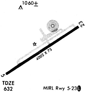
| Runways: | 06/24 |
| Longest Runway: | 06/24 is 4002 ft (1220 m) long |
| Runways with an Instrument Approach: |
KHBZ Airport Runway Details
| Runway 06/24 | 4002 ft x 75 ft (1220 m x 23 m) | |
| Runway Length Source: | NGS as of 06/13/1991 | |
| Surface: | Asphalt - Good condition - No special surface treatment | |
| Runway Edge Lights: | Medium Intensity | |
Runway Weight Bearing Capacity (in thousands of pounds) |
||
| Single Wheel Landing Gear: | 12.5 | |
Runway 06 |
Runway 24 |
|
Elevation: |
620.4 | 631.9 |
Latitude: |
35-30-32.0700N | 35-30-52.1200N |
Longitude: |
092-01-07.7000W | 092-00-25.9700W |
|
Runway True Alignment: |
060 | 240 |
Glide Path Angle: |
3.0 degrees | 3.0 degrees |
Traffic Pattern: |
Left | Left |
Runway Markings Type: |
Nonprecision Instrument | Nonprecision Instrument |
Runway Markings Condition: |
Good | Good |
Object at End: |
TREES | |
Object Height: |
34 | |
Distance from End: |
705 | |
Object Centerline Offset: |
180 ft. right of centerline | |
Visual Glide Slope Indicators: |
2-Light PAPI On Left Side Of Runway | 2-Light PAPI On Left Side Of Runway |
REIL: |
Yes | Yes |
Threshold Crossing Height: |
36 | 39 |
Services
Airframe Repair: |
Major |
Powerplant Repair: |
Major |
Bottled Oxygen: |
None |
Bulk Oxygen: |
None |
Fuel Available: |
100LL, Jet A |
Landing Fees: |
No |
Parking: |
Tiedowns available |
Maps & Diagrams
KHBZ Sectional
Flight Planning
at skyvector.com
at skyvector.com