Location
Latitude: |
35-38-15.8000N (35.637722) |
Longitude: |
091-10-35.0000W (-91.176389) |
Elevation: |
238.9 feet MSL (73 m MSL) |
Magnetic Variation: |
1 W (as of April 2024 from WMM2020 model) |
Time Zone: |
UTC -6.0 (Standard Time) UTC -5.0 (Daylight Savings Time) |
From City: |
05 N.M. NE of Newport, Arkansas |
Found On: |
Memphis Chart |
FAA Region: |
ASW |
Contacts
Manager: |
Publicly owned: |
| THOMAS SANDERS 3800 OPERATIONS DRIVE NEWPORT, AR 72112 870-523-3613 |
CITY OF NEWPORT 615 3RD ST NEWPORT, AR 72112 870-523-6568 |
Operations
Airport Status: |
Operational |
Facility Use: |
Public |
Type: |
Airport |
Activation Date: |
12/1943 |
Control tower: |
No |
Attendance (Months/Days/Hours): |
Months/Days/Hours ALL/MON-FRI/0800-1700 |
Boundary ARTCC: |
ZME (Memphis) |
Responsible ARTCC: |
ZME (Memphis) |
Lighting Schedule: |
SEE RMK |
Segmented Circle Indicator: |
No |
Traffic Pattern Altitude (MSL): |
1239 feet (378 m) |
NOTAMs Facility: |
M19 |
NOTAM-D Service: |
Yes |
International Airport of Entry: |
No |
Customs Landing Rights: |
No |
Military Landing Rights: |
Yes |
Civil/Military Joint Use: |
No |
Based Aircraft
| Single Engine: | 13 |
| Multi Engine: | 4 |
| Jet Engine: | 1 |
Annual Operations (as of 02/28/2022)
| Total Operations: | 8600 | |
| GA Local: | 1500 | 17.4% |
| GA Itinerant: | 7000 | 81.4% |
| Military Aircraft: | 100 | 1.2% |
Communications
| CTAF: | 122.800 |
| Unicom: | 122.800 |
| AWOS-3PT: | 118.15 (870-523-2189) |
- APCH/DEP SVC PRVDD BY MEMPHIS ARTCC ON FREQS 120.075/289.4 (WALNUT RIDGE RCAG).
Fixed Based Operators (FBOs) & Fuel
(Click on a business for detail)
Please help us keep this information up to date. This is a FREE SERVICE just like everything else on Airport Guide! If you see that a business needs to be added, modified, or deleted please fill out our Update Form.
To add, modify, or delete a business click here.
Please help us keep this information up to date. This is a FREE SERVICE just like everything else on Airport Guide! If you see that a business needs to be added, modified, or deleted please fill out our Update Form.
Area Code: 870 |
| Business Name | Frequency | Phone | Fuel Grade |
|---|---|---|---|
| Newport Municipal
Update FBO info |
Unicom 122.8 | 523-3613 | 100LL, Jet A |
Flight Service Stations
| Primary | Alternate | |
| FSS on Field: | N | |
| FSS Name (ID): | Jonesboro(JBR) | |
| Frequency: | ||
| Toll Free Phone: | 1-800-WX-BRIEF |
Instrument Procedures / Charts
FAA Terminal Procedures valid from 0901Z 03/21/24 to 0901Z 04/18/24.
There are various types of charts available for an airport. They are listed in the Page Type column. Here is a legend for those types:
APD - Airport Diagram
DP - Departure Procedure Charts
HOT - Hot Spots
IAP - Instrument Approach Procedure Charts
MIN - Minimums
STAR - Standard Terminal Arrival Charts
| Page Type | Page Name | Volume | Action Since Last Cycle |
|---|---|---|---|
| IAP | RNAV (GPS) RWY 18 | SC-1 | |
| IAP | RNAV (GPS) RWY 36 | SC-1 | |
| IAP | VOR RWY 18 | SC-1 | |
| MIN | ALTERNATE MINIMUMS | SC-1 | |
| MIN | TAKEOFF MINIMUMS | SC-1 |
Terminal Procedures are only available for airports in several countries with more being added all the time. If you are looking for a specific country's charts, please send an email to support(at)airportguide.com stating the country name. This will be used to prioritize the implementation.
Navigation Aids (Navaids) near M19
| Dist (NM) | ID | Morse Code | Name | Type | Freq | True Hdg | Mag Hdg |
|---|---|---|---|---|---|---|---|
| 30.3 | ARG | . _ . _ . _ _ . | Walnut Ridge | VORTAC | 114.50 | 20 | 21 |
| 30.5 | BV | _ . . . . . . _ | Almnd | NDB | 335 | 277 | 278 |
| 32.0 | JBR | . _ _ _ _ . . . . _ . | Jonesboro | VOR-DME | 115.85 | 63 | 64 |
| 36.3 | TNZ | _ _ . _ _ . . | Lawrence County | NDB | 227 | 19 | 20 |
| 38.3 | GQE | _ _ . _ _ . _ . | Gilmore | VOR-DME | 113.00 | 116 | 117 |
| 42.1 | DS | _ . . . . . | Cercy | NDB | 375 | 222 | 223 |
| 58.3 | TYV | _ _ . _ _ . . . _ | Toneyville | NDB | 290 | 225 | 226 |
| 60.9 | SPQ | . . . . _ _ . _ _ . _ | Spain | NDB | 414 | 115 | 116 |
| 61.9 | SGT | . . . _ _ . _ | Stuttgart | NDB | 269 | 199 | 200 |
| 63.0 | GOJ | _ _ . _ _ _ . _ _ _ | Gosnell | VOR | 111.80 | 72 | 73 |
| 64.2 | ME | _ _ . | Elvis | NDB | 287 | 122 | 123 |
| 64.4 | MIG | _ _ . . _ _ . | Millington | NDB | 232 | 109 | 110 |
| 64.6 | LRF | . _ . . . _ . . . _ . | Jacksonville | TACAN | 109.20 | 228 | 229 |
| 68.3 | MEM | _ _ . _ _ | Memphis Metropolitn | VOT | 111.00 | 120 | 121 |
| 68.4 | UJM | . . _ . _ _ _ _ _ | Marvell | VOR-DME | 109.60 | 158 | 159 |
| 69.3 | MEM | _ _ . _ _ | Memphis | VORTAC | 117.50 | 122 | 123 |
| 69.6 | CWS | _ . _ . . _ _ . . . | Conway | NDB | 302 | 241 | 242 |
| 70.8 | TT | _ _ | Stutt | NDB | 338 | 196 | 197 |
| 73.8 | FLP | . . _ . . _ . . . _ _ . | Flippin | DME | 116.05 | 302 | 303 |
| 74.3 | FD | . . _ . _ . . | Earli | NDB | 278 | 33 | 34 |
Nearby Airports with Fuel
Notices to Airmen (NOTAMS)
Remarks
| A110-1 | NUMEROUS AGRICULTURAL OPNS MARCH THRU AUGUST |
| A110-2 | FOR CD CTC MEMPHIS ARTCC AT 901-368-8453/8449. |
| A17 | FOR SVC AFT HRS CALL 870-217-1400 |
| A70-FUEL-10 | 0LL SELF SVC FUEL AVBL AFT HRS WITH CREDIT CARD JET A & 100LL. |
| A81-APT | DUSK-DAWN. ACTVT MIRL RWY 18/36 - CTAF |
| E111 | PRE DATES THE ACT. |
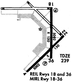
Runways
Runway Summary
| Runways: | 04/22 18/36 |
| Longest Runway: | 04/22 is 5002 ft (1525 m) long |
| Runways with an Instrument Approach: |
M19 Airport Runway Details
| Runway 04/22 | 5002 ft x 150 ft (1525 m x 46 m) | |
| Surface: | Concrete - Good condition - No special surface treatment | |
Runway Weight Bearing Capacity (in thousands of pounds) |
||
| Single Wheel Landing Gear: | 30.0 | |
Runway 04 |
Runway 22 |
|
Elevation: |
235.0 | 237.0 |
Latitude: |
35-37-47.8580N | 35-38-23.4410N |
Longitude: |
091-10-59.4630W | 091-10-17.3630W |
|
Runway True Alignment: |
044 | 224 |
Glide Path Angle: |
0.0 degrees | 0.0 degrees |
Traffic Pattern: |
Right | Left |
Runway Markings Type: |
Nonprecision Instrument | Nonprecision Instrument |
Runway Markings Condition: |
Good | Good |
| Runway 18/36 | 5002 ft x 150 ft (1525 m x 46 m) | |
| Runway Length Source: | 3RD PARTY SURVEY as of 06/27/2007 | |
| Surface: | Concrete - Good condition - No special surface treatment | |
| Runway Edge Lights: | Medium Intensity | |
Runway Weight Bearing Capacity (in thousands of pounds) |
||
| Single Wheel Landing Gear: | 30.0 | |
Runway 18 |
Runway 36 |
|
Elevation: |
238.4 | 238.9 |
Latitude: |
35-38-50.6838N | 35-38-01.2203N |
Longitude: |
091-10-31.0242W | 091-10-32.1019W |
|
Runway True Alignment: |
181 | 001 |
Glide Path Angle: |
3.0 degrees | 3.0 degrees |
Traffic Pattern: |
Left | Right |
Runway Markings Type: |
Nonprecision Instrument | Nonprecision Instrument |
Runway Markings Condition: |
Fair | Fair |
Object at End: |
PLINE | |
Object Height: |
32 | |
Distance from End: |
1740 | |
Visual Glide Slope Indicators: |
4-Light PAPI On Left Side Of Runway | 4-Light PAPI On Right Side Of Runway |
REIL: |
Yes | Yes |
Threshold Crossing Height: |
44 | 44 |
Services
Fuel Available: |
100LL, Jet A+ |
Landing Fees: |
No |
Parking: |
Tiedowns available |
Maps & Diagrams
M19 Sectional
Flight Planning
at skyvector.com
at skyvector.com