Location
Latitude: |
34-56-31.1930N (34.941998) |
Longitude: |
090-46-29.8780W (-90.774966) |
Elevation: |
249.2 feet MSL (76 m MSL) |
Magnetic Variation: |
1.3 W (as of April 2024 from WMM2020 model) |
Time Zone: |
UTC -6.0 (Standard Time) UTC -5.0 (Daylight Savings Time) |
From City: |
04 N.M. S of Forrest City, Arkansas |
Found On: |
Memphis Chart |
FAA Region: |
ASW |
Contacts
Manager: |
Privately owned: |
| GIL GILBREATH BOX 1296 HWY 980 FORREST CITY, AR 72335 870-633-4511 |
HUTFLY, LLC PO BOX 1074 FORREST CITY, AR 72335 870-633-1315 |
Operations
Airport Status: |
Operational |
Facility Use: |
Public |
Type: |
Airport |
Activation Date: |
08/1960 |
Control tower: |
No |
Attendance (Months/Days/Hours): |
Months/Days/Hours ALL/MON-FRI/0800-1700 |
Boundary ARTCC: |
ZME (Memphis) |
Responsible ARTCC: |
ZME (Memphis) |
Lighting Schedule: |
SEE RMK |
Segmented Circle Indicator: |
Yes |
Traffic Pattern Altitude (MSL): |
1249 feet (381 m) |
NOTAMs Facility: |
JBR |
NOTAM-D Service: |
Yes |
International Airport of Entry: |
No |
Customs Landing Rights: |
No |
Military Landing Rights: |
Yes |
Civil/Military Joint Use: |
No |
Based Aircraft
| Single Engine: | 3 |
Annual Operations (as of 08/31/2016)
| Total Operations: | 31300 | |
| GA Local: | 30000 | 95.8% |
| GA Itinerant: | 1000 | 3.2% |
| Military Aircraft: | 300 | 1.0% |
Communications
| CTAF: | 122.800 |
| Unicom: | 122.800 |
- APCH/DEP SVC PRVDD BY MEMPHIS ARTCC ON FREQS 135.3/335.8(BRINKLEY RCAG).
Fixed Based Operators (FBOs) & Fuel
(Click on a business for detail)
Please help us keep this information up to date. This is a FREE SERVICE just like everything else on Airport Guide! If you see that a business needs to be added, modified, or deleted please fill out our Update Form.
To add, modify, or delete a business click here.
Please help us keep this information up to date. This is a FREE SERVICE just like everything else on Airport Guide! If you see that a business needs to be added, modified, or deleted please fill out our Update Form.
Area Code: 870 |
| Business Name | Frequency | Phone | Fuel Grade |
|---|---|---|---|
| Hutcherson Flying Service
Update FBO info |
Unicom 122.8 | 633-4511 | 100LL, Jet A |
Flight Service Stations
| Primary | Alternate | |
| FSS on Field: | N | |
| FSS Name (ID): | Jonesboro(JBR) | |
| Frequency: | ||
| Toll Free Phone: | 1-800-WX-BRIEF |
Instrument Procedures / Charts
| Page Type | Page Name | Volume | Action Since Last Cycle |
|---|
Terminal Procedures are only available for airports in several countries with more being added all the time. If you are looking for a specific country's charts, please send an email to support(at)airportguide.com stating the country name. This will be used to prioritize the implementation.
Navigation Aids (Navaids) near FCY
| Dist (NM) | ID | Morse Code | Name | Type | Freq | True Hdg | Mag Hdg |
|---|---|---|---|---|---|---|---|
| 22.6 | UJM | . . _ . _ _ _ _ _ | Marvell | VOR-DME | 109.60 | 167 | 168 |
| 28.3 | GQE | _ _ . _ _ . _ . | Gilmore | VOR-DME | 113.00 | 30 | 31 |
| 35.3 | ME | _ _ . | Elvis | NDB | 287 | 78 | 80 |
| 38.8 | SPQ | . . . . _ _ . _ _ . _ | Spain | NDB | 414 | 66 | 68 |
| 39.2 | MEM | _ _ . _ _ | Memphis | VORTAC | 117.50 | 83 | 85 |
| 39.5 | MEM | _ _ . _ _ | Memphis Metropolitn | VOT | 111.00 | 80 | 82 |
| 43.5 | SGT | . . . _ _ . _ | Stuttgart | NDB | 269 | 247 | 248 |
| 46.0 | MIG | _ _ . . _ _ . | Millington | NDB | 232 | 63 | 65 |
| 47.6 | TT | _ _ | Stutt | NDB | 338 | 236 | 237 |
| 49.7 | DS | _ . . . . . | Cercy | NDB | 375 | 282 | 283 |
| 56.7 | JBR | . _ _ _ _ . . . . _ . | Jonesboro | VOR-DME | 115.85 | 9 | 10 |
| 61.2 | TYV | _ _ . _ _ . . . _ | Toneyville | NDB | 290 | 270 | 271 |
| 63.8 | HLI | . . . . . _ . . . . | Holly Springs | VORTAC | 112.40 | 98 | 100 |
| 65.8 | UV | . . _ . . . _ | Tunng | NDB | 426 | 120 | 122 |
| 67.8 | BV | _ . . . . . . _ | Almnd | NDB | 335 | 312 | 313 |
| 68.0 | LRF | . _ . . . _ . . . _ . | Jacksonville | TACAN | 109.20 | 269 | 270 |
| 69.7 | FYE | . . _ . _ . _ _ . | Somerville | NDB | 255 | 76 | 78 |
| 70.0 | COO | _ . _ . _ _ _ _ _ _ | Covington | NDB | 326 | 55 | 57 |
| 70.5 | PBF | . _ _ . _ . . . . . _ . | Pine Bluff | VOR-DME | 116.00 | 234 | 235 |
| 70.6 | ARG | . _ . _ . _ _ . | Walnut Ridge | VORTAC | 114.50 | 352 | 353 |
Nearby Airports with Fuel
Notices to Airmen (NOTAMS)
Remarks
| A110*G | THIS AIRPORT HAS BEEN SURVEYED BY THE NATIONAL GEODETIC SURVEY. |
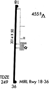
| A110-3 | 494 FT LGTD TWR 3 MILES NORTH ON CNTRLN. |
| A110-4 | RY 36 DITCH 201 FT FROM SOUTH END OF RY. |
| A110-5 | FOR CD CTC MEMPHIS APCH AT 901-842-8457. |
| A43-18 | PAPI RWY 18/36 OTS INDEFLY. |
| A48-18 | REIL RWY 18/36 OTS INDEFLY. |
| A80 | ROTG BCN OTS INDEFLY. |
| A81-APT | DUSK-DAWN. ACTVT PAPI RWY 18 & 36; MIRL RWY 18/36 - CTAF. |
Runways
Runway Summary
| Runways: | 18/36 |
| Longest Runway: | 18/36 is 3014 ft (919 m) long |
| Runways with an Instrument Approach: |
FCY Airport Runway Details
| Runway 18/36 | 3014 ft x 50 ft (919 m x 15 m) | |
| Surface: | Asphalt - Fair condition - No special surface treatment | |
| Runway Edge Lights: | Medium Intensity | |
Runway Weight Bearing Capacity (in thousands of pounds) |
||
| Single Wheel Landing Gear: | 20.0 | |
Runway 18 |
Runway 36 |
|
Elevation: |
249.0 | 242.5 |
Latitude: |
34-56-46.0960N | 34-56-16.2910N |
Longitude: |
090-46-29.5620W | 090-46-30.1950W |
|
Runway True Alignment: |
181 | 001 |
Glide Path Angle: |
4.0 degrees | 4.0 degrees |
Traffic Pattern: |
Left | Left |
Runway Markings Type: |
Basic | Nonprecision Instrument |
Runway Markings Condition: |
Fair | Fair |
Object at End: |
TREES | |
Object Height: |
30 | |
Distance from End: |
1200 | |
Object Centerline Offset: |
225 ft. right of centerline | |
Visual Glide Slope Indicators: |
2-Light PAPI On Left Side Of Runway | 2-Light PAPI On Right Side Of Runway |
REIL: |
Yes | Yes |
Threshold Crossing Height: |
36 | 36 |
Services
Airframe Repair: |
Major |
Powerplant Repair: |
Major |
Bottled Oxygen: |
None |
Bulk Oxygen: |
None |
Fuel Available: |
100LL, Jet A+ |
Landing Fees: |
No |
Parking: |
Hangars and tiedowns available |
Maps & Diagrams
FCY Sectional
Flight Planning
at skyvector.com
at skyvector.com