
Location
Latitude: |
33-49-04.5470N (33.81793) |
Longitude: |
118-09-06.8060W (-118.151891) |
Elevation: |
60.4 feet MSL (18 m MSL) |
Magnetic Variation: |
11.4 E (as of April 2024 from WMM2020 model) |
Time Zone: |
UTC -8.0 (Standard Time) UTC -7.0 (Daylight Savings Time) |
From City: |
03 N.M. NE of Long Beach, California |
Found On: |
Los Angeles Chart |
FAA Region: |
AWP |
Contacts
Manager: |
Publicly owned: |
| CYNTHIA GUIDRY 4100 DONALD DOUGLAS DR LONG BEACH, CA 90808 (562) 570-2605 |
CITY OF LONG BEACH CITY HALL 333 W. OCEAN LONG BEACH, CA 90802 562-570-2600 |
Operations
Airport Status: |
Operational |
Facility Use: |
Public |
Type: |
Airport |
Activation Date: |
04/1940 |
Control tower: |
Yes |
Attendance (Months/Days/Hours): |
Months/Days/Hours ALL/ALL/ALL |
Boundary ARTCC: |
ZLA (Los Angeles) |
Responsible ARTCC: |
ZLA (Los Angeles) |
Lighting Schedule: |
SEE RMK |
Segmented Circle Indicator: |
No |
Traffic Pattern Altitude (MSL): |
1060 feet (323 m) |
NOTAMs Facility: |
LGB |
NOTAM-D Service: |
Yes |
International Airport of Entry: |
No |
Customs Landing Rights: |
No |
Military Landing Rights: |
Yes |
Civil/Military Joint Use: |
No |
Aircraft Rescue and Firefighting: |
Class I ARFF Index: C Air Carrier Service: Scheduled Certification Date: 05/1973 |
Based Aircraft
| Single Engine: | 255 |
| Multi Engine: | 72 |
| Jet Engine: | 37 |
| GA Helicopters: | 34 |
Annual Operations (as of 11/01/2023)
| Total Operations: | 374956 | |
| Commercial: | 34633 | 9.2% |
| Air Taxi: | 11481 | 3.1% |
| GA Local: | 122700 | 32.7% |
| GA Itinerant: | 205496 | 54.8% |
| Military Aircraft: | 646 | 0.2% |
Communications
| CTAF: | 119.400 |
| Unicom: | 122.950 |
| Tower: | LONG BEACH 119.4 ;RWY 30 APCH, RWY 12 DEP 120.5 ;RWY 12 APCH, RWY 30 DEP 257.6 Hrs: 0615-2345 |
| Clearance Del.: | 118.15 |
| Ground: | 133.0 257.6 |
| Approach: | SOCAL |
| Departure: | SOCAL |
| ATIS: | 127.75 Hrs: 24 |
| ASOS: | (562-424-0572) |
| EMERG: | 121.5 |
| EMERG: | 243.0 |
- TA31
Fixed Based Operators (FBOs) & Fuel
(Click on a business for detail)
Please help us keep this information up to date. This is a FREE SERVICE just like everything else on Airport Guide! If you see that a business needs to be added, modified, or deleted please fill out our Update Form.
click here.
Please help us keep this information up to date. This is a FREE SERVICE just like everything else on Airport Guide! If you see that a business needs to be added, modified, or deleted please fill out our Update Form.
Area Code: 562 |
Flight Service Stations
| Primary | Alternate | |
| FSS on Field: | N | |
| FSS Name (ID): | Hawthorne(HHR) | |
| Frequency: | ||
| Toll Free Phone: | 1-800-WX-BRIEF |
Instrument Procedures / Charts
FAA Terminal Procedures valid from 0901Z 03/21/24 to 0901Z 04/18/24.
There are various types of charts available for an airport. They are listed in the Page Type column. Here is a legend for those types:
APD - Airport Diagram
DP - Departure Procedure Charts
HOT - Hot Spots
IAP - Instrument Approach Procedure Charts
MIN - Minimums
STAR - Standard Terminal Arrival Charts
Terminal Procedures are only available for airports in several countries with more being added all the time. If you are looking for a specific country's charts, please send an email to support(at)airportguide.com stating the country name. This will be used to prioritize the implementation.
Navigation Aids (Navaids) near LGB
| Dist (NM) | ID | Morse Code | Name | Type | Freq | True Hdg | Mag Hdg |
|---|---|---|---|---|---|---|---|
| 5.2 | LG | . _ . . _ _ . | Becca | NDB | 233 | 134 | 123 |
| 5.3 | SLI | . . . . _ . . . . | Seal Beach | VORTAC | 115.70 | 113 | 102 |
| 6.4 | CPM | _ . _ . . _ _ . _ _ | Compton | NDB | 378 | 311 | 300 |
| 10.2 | LAX | . _ . . . _ _ . . _ | San Pedro Hill | VOT | 113.90 | 244 | 233 |
| 15.6 | LAX | . _ . . . _ _ . . _ | Los Angeles | VORTAC | 113.60 | 296 | 285 |
| 16.5 | SNA | . . . _ . . _ | Santa Ana | VOT | 110.00 | 120 | 109 |
| 17.3 | EMT | . _ _ _ | El Monte | NDB | 359 | 20 | 9 |
| 19.1 | SMO | . . . _ _ _ _ _ | Santa Monica | VOR-DME | 110.80 | 307 | 296 |
| 22.7 | ELB | . . _ . . _ . . . | El Toro | VOR-DME | 117.20 | 111 | 100 |
| 24.0 | POM | . _ _ . _ _ _ _ _ | Pomona | VORTAC | 110.40 | 49 | 38 |
| 25.4 | UR | . . _ . _ . | Vinee | NDB | 253 | 333 | 322 |
| 29.5 | PAI | . _ _ . . _ . . | Pacoima | NDB | 370 | 333 | 322 |
| 29.6 | VNY | . . . _ _ . _ . _ _ | Van Nuys | VOR-DME | 113.10 | 325 | 314 |
| 29.8 | SXC | . . . _ . . _ _ . _ . | Santa Catalina | VORTAC | 114.15 | 206 | 195 |
| 31.6 | PDZ | . _ _ . _ . . _ _ . . | Paradise | VORTAC | 112.20 | 78 | 67 |
| 35.9 | RAL | . _ . . _ . _ . . | Riverside | VOR | 108.60 | 76 | 65 |
| 41.7 | SB | . . . _ . . . | Petis | NDB | 397 | 69 | 58 |
| 44.0 | RIV | . _ . . . . . . _ | March | TACAN | 113.00 | 82 | 71 |
| 48.1 | VTU | . . . _ _ . . _ | Ventura | VOR-DME | 108.20 | 292 | 280 |
| 48.3 | HDF | . . . . _ . . . . _ . | Homeland | VOR | 112.05 | 92 | 81 |
Nearby Airports with Fuel
Notices to Airmen (NOTAMS)
Remarks
| A110-10 | 6 FT LIGHTED CHAIN LINK FENCE LCTD 130 FT SOUTH OF CNTRLN OF TWY F. FENCE BEGINS NW CORNER OF ATCT & EXTENDS 400 FT TO WEST. |
| A110-13 | ENGINE RUN-UPS, OTHER THAN PRE-FLIGHT, ARE LIMITED TO HRS OF 0700-2100 WEEKDAYS & 0900-2100 WEEKENDS & HOLIDAYS. |
| A110-19 | HELIPAD H2, H4, & H5 20 X 20 ASPH. HELIPAD H3 35 X 300 ASPH. |
| A110-3 | RY 12/30 FAA STRENGTH EVALUATION DC-10-10 440000 LBS; DC-10-30 550000 LBS; L-1011 460000 LBS. |
| A110-30 | MAX LDG WGT FOR C17AT OR BYD GLIDE SLOPE OR RY AIMING POINT MARKING 538600 LBS; RY 30 LDG PRIOR TORY AIMING POINT MARKING 344000 LBS. |
| A110-31 | AIRSHIPS MOORED IN INFIELD AND OPERATING INVOF ARPT. |
| A110-34 | MAX TKOF WGT DC-10 30/40 & MD-11 588100 LBS; C-17 538600 LBS. TWYS D3 & L3 WGT LIMITS A-340 DC-10 30/40 & MD-11 541000 LBS; C-17 450000 LBS. |
| A110-35 | (A35-30) MAX LDG WGTS A-330 347000 LBS; A-340 379000 LBS; DC-10-10 & C-17 344000 LBS; DC10 3/40 & MD-11 379000 LBS; L-1011 354000 LBS. RY 12 MAX LDG WGT DC-10 30/40 & MD-11 588100 LBS; C-17 538600 LBS. |
| A110-38 | NO TWY ACCESS TO RWY 08L W OF TWY D; 4897 FT REMAINING ON RWY 08L FROM TWY D. |
| A110-39 | 24 HR PRIOR NOTICE REQUESTED FOR MILITARY JETS AND CIVILIAN NON-STAGE III JETS, CTC NOISE ABATEMENT (562) 570-2635 OR FREQ 122.85 MON-FRI 0730-1630. |
| A110-4 | ALL RYS CLSD 2200-0700 LCL EXCP RY 12/30. |
| A110-43 | BIRDS ON & INV OF ARPT |
| A110-46 | TRNG HELIPADS H2, H3 & H4 LOCATED N OF RWY 12/30 MIDFIELD BTN TWYS G & K. TRNG HELIPAD H5 LOCATED S OF RWY 12/30 BTN TWYS D & J FOR HOVER WORK ONLY. |
| A110-47 | NO RUNNING LDGS/TKOFS BY HELS WITH SKID-TYPE LDG GEAR, ON RWY 08L-26R. ROLLING LDGS/TKOFS WITH HELS WITH WHEEL-TYPE LDG GEAR ARE PMTD. |
| A110-49 | TOUCH & GO, STOP & GO, PRACTICE LOW APCH, VFR PRACTICE MISSED APCH ONLY PMTD 0700-1900 WKDAYS & 0800-1500 WKENDS & HOLS ONLY ON RWYS 08L/26R & 08R/26L. |
| A110-50 | NO FLD COND NOTAMS AVBL 2200-0700. |
| A110-51 | ALL ACFT ON OR ENTERING LEFT DOWNWIND RWY 26L MUST REMAIN NORTH OF SIGNAL HILL UNLESS SPECIFICALLY INSTRUCTED BY ATC OTHERWISE. |
| A110-52 | ALL ACFT ON DOWNWIND RWY 26L ARE NOT AUTH TO TURN BASE OR BEGIN DESCENT UNTIL EAST OF RWY 30 UNLESS SPECIFICALLY INSTRUCTED TO DO SO BY ATC. |
| A110-53 | ALL ACFT ON DOWNWIND RWY 08L ARE NOT AUTH TO TURN BASE OR BEGIN DESCENT UNTIL WEST OF RWY 12 UNLESS SPECIFICALLY INSTRUCTED TO DO SO BY ATC. |
| A110-54 | FOR CD WHEN ATCT CLSD CTC SOCAL APCH AT 800-448-3724. |
| A110-55 | RWY 8R/26L NOT AVBL FOR SKED ACR OPNS WITH MORE THAN 9 PSGR SEATS OR UNSKED ACR OPNS WITH AT LEAST 31 PSGR SEATS. |
| A110-6 | RY 12/30 LGTD DISTANCE REMAINING SIGNS WEST SIDE. |
| A110-7 | NOISE LIMITS (DECIBELS SGL EVENT NOISE EXPOSURE LEVEL) RWY 26R TKOF 92.0 LDG 88.0; RWY 08L TKOF 88.0 LDG 92.0; RWY 26L TKOF 95.0 LDG 93.0; RWY 08R TKOF 95.0 LDG 92.0. RWYS 12 & 30 0700-2200 TKOF 102.5 LDG 101.5; 0600-0700 & 2200-2300 TKOF 90.0 LDG 90.0; 2300-0600 TKOF 79.0 LDG 79.0. |
| A110-9 | TWYS D3 AND L3 WGT LIMITS A340 DC10 30/40 & MD11 541000 LBS; C17 450000 LBS. |
| A14 | DIRECTOR |
| A16 | JUAN LOPEZ-RIOS (DEPUTY DIR) 562-570-2608. RON REEVES (SUPT ARPT OPNS) 562-570-1251. ARPT BUR FAX 562-570-2601; NOISE COMPLAINTS PUB AFFAIRS 562-570-2665. |
| A35-12/30 | MAX LDG WGTS A-330 347000 LBS; A-340 379000 LBS; DC-10-10 DC-10 30/40 & MD-11 379000 LBS; L-1011 354000 LBS. RY 12/30 MAX TKOF WGTS DC-10 30/40 & MD-11 588000 LBS; C-17 538600 LBS. |
| A52-08R | LGTD TOWER 152 FT AGL 2500 FT WEST & 500 FT SOUTH OF RY THLD. |
| A57-08L | APCH RATIO 20:1 TO DSPLCD THR. |
| A57-12 | APCH RATIO 50:1 TO DSPLCD THR. |
| A57-26R | APCH RATIO 34:1 TO DSPLCD THR. |
| A57-30 | APCH RATIO 50:1 TO DSPLCD THR. |
| A58-08L | 6 FT FENCE 190 FT FM RY END WITH OBSTRUCTION LGT. |
| A58-12 | 6 FT POLE 190 FT FM RY END; FENCE 490 FT L OF CNTRLN. |
| A81-APT | WHEN ATCT CLSD ACTVT MALSR RWY 30; REIL RWYS 08R, 12, 26L & 26R; PAPI RWYS 12, 08R, 26L & 26R; HIRL RWY 08R/26L; MIRL RWY 08L/26R - CTAF. HIRL, TDZL & CL LIGHTS RWY 12/30 OPER CONSLY WHEN ATCT CLSD. PAPI RWY 30 OPER CONSLY. |
| E111 | PRVDD DAY USE ONLY; OPNS COORDINATED WITH ATCT. |
Runways
Runway Summary
| Runways: | 08L/26R 08R/26L 12/30 H2 H3 H4 H5 |
| Longest Runway: | 12/30 is 10000 ft (3048 m) long |
| Runways with an Instrument Approach: | 30 |
LGB Airport Runway Details
| Runway 08L/26R | 6192 ft x 150 ft (1887 m x 46 m) | |
| Runway Length Source: | 3RD PARTY SURVEY as of 01/13/2016 | |
| Surface: | Asphalt - Excellent condition - Saw-cut or plastic grooved | |
| Runway Pavement Class: | 54 /F/B/W/T | |
| Runway Edge Lights: | Medium Intensity | |
Runway Weight Bearing Capacity (in thousands of pounds) |
||
| Single Wheel Landing Gear: | 30.0 | |
| Dual Wheel Landing Gear: | 70.0 | |
| Dual Tandem Wheel Landing Gear: | 110.0 | |
Runway 08L |
Runway 26R |
|
Elevation: |
58.1 | 38.1 |
Latitude: |
33-49-21.9369N | 33-49-21.7158N |
Longitude: |
118-09-48.6878W | 118-08-35.2938W |
|
Runway True Alignment: |
090 | 270 |
Glide Path Angle: |
0.0 degrees | 3.1 degrees |
Traffic Pattern: |
Left | Right |
Runway Markings Type: |
Nonprecision Instrument | Nonprecision Instrument |
Runway Markings Condition: |
Good | Good |
Object at End: |
POLE | ROAD |
Object Height: |
78 | 16 |
Distance from End: |
200 | 300 |
Object Centerline Offset: |
36 ft. right of centerline | 200 ft. right of centerline |
Visual Glide Slope Indicators: |
4-Light PAPI On Left Side Of Runway | |
REIL: |
No | Yes |
Touchdown Lights: |
No | No |
Centerline Lights: |
No | No |
Threshold Crossing Height: |
62 | |
Threshold Elevation: |
52.8 | 39.5 |
Displaced Threshold: |
1305 | 532 |
Threshold Latitude: |
33-49-21.8937N | 33-49-21.7368N |
Threshold Longitude: |
118-09-33.2150W | 118-08-41.5992W |
Declared Distances |
||
Take Off Run Avbl. (TORA): |
6192 | 6192 |
Take Off Distance Avbl. (TODA): |
6192 | 6192 |
Actual Stop Dist. Avbl. (ASDA): |
6192 | 6192 |
Landing Dist. Avbl. (LDA): |
4887 | 5660 |
| Runway 08R/26L | 3918 ft x 100 ft (1194 m x 30 m) | |
| Runway Length Source: | STATE as of 01/20/2017 | |
| Surface: | Asphalt - Excellent condition - No special surface treatment | |
| Runway Pavement Class: | 61 /F/C/X/U | |
| Runway Edge Lights: | High Intensity | |
Runway Weight Bearing Capacity (in thousands of pounds) |
||
| Single Wheel Landing Gear: | 30.0 | |
| Dual Wheel Landing Gear: | 75.0 | |
Runway 08R |
Runway 26L |
|
Elevation: |
52.9 | 34.6 |
Latitude: |
33-48-50.0300N | 33-48-50.0600N |
Longitude: |
118-09-40.6900W | 118-08-54.2500W |
|
Runway True Alignment: |
090 | 270 |
Glide Path Angle: |
3.0 degrees | 3.0 degrees |
Traffic Pattern: |
Right | Left |
Runway Markings Type: |
Nonprecision Instrument | Nonprecision Instrument |
Runway Markings Condition: |
Good | Good |
Object at End: |
TOWER | TREES |
Object Height: |
102 | 61 |
Object Marked/Lighted?: |
Lighted | |
Distance from End: |
2500 | 1420 |
Object Centerline Offset: |
36 ft. right of centerline | 200 ft. right of centerline |
Visual Glide Slope Indicators: |
4-Light PAPI On Left Side Of Runway | 4-Light PAPI On Left Side Of Runway |
REIL: |
Yes | Yes |
Touchdown Lights: |
No | No |
Centerline Lights: |
No | No |
Threshold Crossing Height: |
38 | 34 |
Declared Distances |
||
Take Off Run Avbl. (TORA): |
3918 | 3918 |
Take Off Distance Avbl. (TODA): |
3918 | 3918 |
Actual Stop Dist. Avbl. (ASDA): |
3918 | 3918 |
Landing Dist. Avbl. (LDA): |
3918 | 3918 |
| Runway 12/30 | 10000 ft x 200 ft (3048 m x 61 m) | |
| Runway Length Source: | 3RD PARTY SURVEY as of 01/13/2016 | |
| Surface: | Asphalt - Excellent condition - Saw-cut or plastic grooved | |
| Runway Pavement Class: | 62 /F/A/X/T | |
| Runway Edge Lights: | High Intensity | |
Runway Weight Bearing Capacity (in thousands of pounds) |
||
| Single Wheel Landing Gear: | 30.0 | |
| Dual Wheel Landing Gear: | 200.0 | |
| Dual Tandem Wheel Landing Gear: | 300.0 | |
Runway 12 |
Runway 30 |
|
Elevation: |
60.4 | 25.7 |
Latitude: |
33-49-34.3313N | 33-48-24.7204N |
Longitude: |
118-09-41.5246W | 118-08-17.3167W |
|
Runway True Alignment: |
135 | 315 |
ILS Type: |
ILS | |
Glide Path Angle: |
3.0 degrees | 3.0 degrees |
Traffic Pattern: |
Left | Left |
Runway Markings Type: |
Precision Instrument | Precision Instrument |
Runway Markings Condition: |
Good | Good |
Object at End: |
FENCE | TREE |
Object Height: |
8 | 42 |
Distance from End: |
200 | 1480 |
Object Centerline Offset: |
36 ft. right of centerline | 200 ft. right of centerline |
Visual Glide Slope Indicators: |
4-Light PAPI On Left Side Of Runway | 4-Light PAPI On Left Side Of Runway |
Runway Visual Range (RVR): |
Rollout | Touchdown |
Approach Light System: |
1,400 Foot Medium Intensity Approach Lighting System With Runway Alignment Indicator Lights | |
REIL: |
Yes | No |
Touchdown Lights: |
No | Yes |
Centerline Lights: |
Yes | Yes |
Threshold Crossing Height: |
70 | 64 |
Threshold Elevation: |
52.9 | 31.2 |
Displaced Threshold: |
1350 | 2000 |
Threshold Latitude: |
33-49-24.9374N | 33-48-38.6437N |
Threshold Longitude: |
118-09-30.1555W | 118-08-34.1574W |
Declared Distances |
||
Take Off Run Avbl. (TORA): |
10000 | 10000 |
Take Off Distance Avbl. (TODA): |
10000 | 10000 |
Actual Stop Dist. Avbl. (ASDA): |
10000 | 9414 |
Landing Dist. Avbl. (LDA): |
8650 | 7414 |
| Helipad H2 | 20 ft x 20 ft (6 m x 6 m) | |
| Runway Length Source: | OWNER as of 08/19/2015 | |
| Surface: | Asphalt - Excellent condition - No special surface treatment | |
Helipad H2 |
||
Elevation: |
40.1 | |
Latitude: |
33-49-11.5400N | |
Longitude: |
118-08-59.9300W | |
Glide Path Angle: |
0.0 degrees | 0.0 degrees |
Runway Markings Type: |
Numbers Only | |
Runway Markings Condition: |
Good | |
Object Centerline Offset: |
36 ft. right of centerline | 200 ft. right of centerline |
| Helipad H3 | 300 ft x 35 ft (91 m x 11 m) | |
| Runway Length Source: | OWNER as of 08/19/2015 | |
| Surface: | Asphalt - Excellent condition - No special surface treatment | |
Helipad H3 |
||
Elevation: |
41.9 | |
Latitude: |
33-49-13.6700N | |
Longitude: |
118-09-03.7300W | |
Glide Path Angle: |
0.0 degrees | 0.0 degrees |
Runway Markings Type: |
Numbers Only | |
Runway Markings Condition: |
Good | |
Object Centerline Offset: |
36 ft. right of centerline | 200 ft. right of centerline |
| Helipad H4 | 20 ft x 20 ft (6 m x 6 m) | |
| Runway Length Source: | OWNER as of 08/19/2015 | |
| Surface: | Asphalt - Excellent condition - No special surface treatment | |
Helipad H4 |
||
Elevation: |
43.0 | |
Latitude: |
33-49-15.4200N | |
Longitude: |
118-09-07.7100W | |
Glide Path Angle: |
0.0 degrees | 0.0 degrees |
Runway Markings Type: |
Numbers Only | |
Runway Markings Condition: |
Good | |
Object Centerline Offset: |
36 ft. right of centerline | 200 ft. right of centerline |
| Helipad H5 | 20 ft x 20 ft (6 m x 6 m) | |
| Runway Length Source: | OWNER as of 08/19/2015 | |
| Surface: | Asphalt - Excellent condition - No special surface treatment | |
Helipad H5 |
||
Elevation: |
41.4 | |
Latitude: |
33-48-55.3100N | |
Longitude: |
118-09-17.6700W | |
Glide Path Angle: |
0.0 degrees | 0.0 degrees |
Runway Markings Type: |
Numbers Only | |
Runway Markings Condition: |
Good | |
Object Centerline Offset: |
36 ft. right of centerline | 200 ft. right of centerline |
Services
Airframe Repair: |
Major |
Powerplant Repair: |
Major |
Bottled Oxygen: |
None |
Bulk Oxygen: |
Low Pressure |
Fuel Available: |
100LL, Jet A |
Landing Fees: |
Yes |
Parking: |
Tiedowns available |
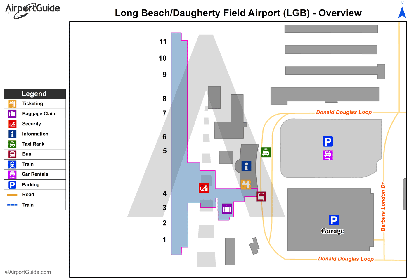
Maps & Diagrams
LGB Sectional
Flight Planning
at skyvector.com
at skyvector.com
 Airport (LGB) Diagram")