Location
Latitude: |
34-12-02.5000N (34.200694) |
Longitude: |
118-21-31.2000W (-118.358667) |
Elevation: |
778.0 feet MSL (237 m MSL) |
Magnetic Variation: |
11.6 E (as of April 2024 from WMM2020 model) |
Time Zone: |
UTC -8.0 (Standard Time) UTC -7.0 (Daylight Savings Time) |
From City: |
03 N.M. NW of Burbank, California |
Found On: |
Los Angeles Chart |
FAA Region: |
AWP |
Contacts
Manager: |
Publicly owned: |
| THOMAS HENDERSON, DIRECTOR OF OPS 2627 HOLLYWOOD WAY BURBANK, CA 91505 818-840-8830 |
BURBANK-GLENDALE-PASADENA APT 2627 HOLLYWOOD WAY BURBANK, CA 91505 818-840-8840 |
Operations
Airport Status: |
Operational |
Facility Use: |
Public |
Type: |
Airport |
Activation Date: |
12/1942 |
Control tower: |
Yes |
Attendance (Months/Days/Hours): |
Months/Days/Hours ALL/ALL/ALL |
Boundary ARTCC: |
ZLA (Los Angeles) |
Responsible ARTCC: |
ZLA (Los Angeles) |
Segmented Circle Indicator: |
No |
Traffic Pattern Altitude (MSL): |
1778 feet (542 m) |
NOTAMs Facility: |
BUR |
NOTAM-D Service: |
Yes |
International Airport of Entry: |
No |
Customs Landing Rights: |
No |
Military Landing Rights: |
Yes |
Civil/Military Joint Use: |
No |
Aircraft Rescue and Firefighting: |
Class I ARFF Index: C Air Carrier Service: Scheduled Certification Date: 05/1973 |
Based Aircraft
| Single Engine: | 22 |
| Multi Engine: | 6 |
| Jet Engine: | 42 |
| GA Helicopters: | 11 |
Annual Operations (as of 02/28/2023)
| Total Operations: | 151916 | |
| Commercial: | 68714 | 45.2% |
| Air Taxi: | 28241 | 18.6% |
| GA Local: | 26063 | 17.2% |
| GA Itinerant: | 28453 | 18.7% |
| Military Aircraft: | 445 | 0.3% |
Communications
| Unicom: | 122.950 |
| Tower: | BURBANK 118.7 132.325 ;HELICOPTERS 254.3 Hrs: 24 |
| Clearance Del.: | 118.0 348.6 |
| Ground: | 123.9 348.6 |
| Approach: | SOCAL |
| Departure: | SOCAL |
| ATIS: | 134.5 135.125 ;ARR VIA FIM/PMD VORTAC ONLY Hrs: 24 |
| ASOS: | (818-841-1384) |
| EMERG: | 121.5 |
| EMERG: | 243.0 |
Fixed Based Operators (FBOs) & Fuel
(Click on a business for detail)
Please help us keep this information up to date. This is a FREE SERVICE just like everything else on Airport Guide! If you see that a business needs to be added, modified, or deleted please fill out our Update Form.
To add, modify, or delete a business click here.
Please help us keep this information up to date. This is a FREE SERVICE just like everything else on Airport Guide! If you see that a business needs to be added, modified, or deleted please fill out our Update Form.
Area Code: 818 |
| Business Name | Frequency | Phone | Fuel Grade |
|---|---|---|---|
| Atlantic Aviation
Website Update FBO info |
Arinc 131.6 | 818-841-2966 | 100LL, Jet A |

|
Chevron |
100LL - 5.46 USD per gallon on 11/1/10 |
Trucks At Tie-down Locations |
|
|
Chevron |
Jet A - 4.70 USD per gallon on 11/1/10 |
Trucks At Tie-down Locations |
| DCL Avionics
Update FBO info |
846-2212 | ||
| Million Air
Website Update FBO info |
Unicom 122.95, Arinc 129.625 | 843-8311 | 100LL, Jet A |
|
|
 Air BP |
100LL - 5.47 USD per gallon on 10/31/10 |
Trucks At Tie-down Locations |
|
|
Air BP |
Jet A - 4.71 USD per gallon on 10/31/10 |
Trucks At Tie-down Locations |
| Pilots Co-Op
Update FBO info |
Unicom 129.95 | 841-6505 | |
| Professional Pilot Training
Update FBO info |
567-4458 |
Flight Service Stations
| Primary | Alternate | |
| FSS on Field: | N | |
| FSS Name (ID): | Hawthorne(HHR) | |
| Frequency: | ||
| Toll Free Phone: | 1-800-WX-BRIEF |
Instrument Procedures / Charts
FAA Terminal Procedures valid from 0901Z 03/21/24 to 0901Z 04/18/24.
There are various types of charts available for an airport. They are listed in the Page Type column. Here is a legend for those types:
APD - Airport Diagram
DP - Departure Procedure Charts
HOT - Hot Spots
IAP - Instrument Approach Procedure Charts
MIN - Minimums
STAR - Standard Terminal Arrival Charts
| Page Type | Page Name | Volume | Action Since Last Cycle |
|---|---|---|---|
| APD | AIRPORT DIAGRAM | SW-3 | |
| DP | ELMOO NINE | SW-3 | |
| DP | OROSZ TWO (RNAV) | SW-3 | |
| DP | SLAPP TWO (RNAV) | SW-3 | |
| DP | SLAPP TWO (RNAV)[DELIMITER] CONT.1 | SW-3 | |
| DP | VAN NUYS THREE | SW-3 | |
| DP | VAN NUYS THREE[DELIMITER] CONT.1 | SW-3 | |
| DP | VVERA TWO (RNAV) | SW-3 | |
| HOT | HOT SPOT | SW-3 | |
| IAP | FOUR STACKS VISUAL RWY 15 | SW-3 | |
| IAP | ILS Y OR LOC Y RWY 08 | SW-3 | Changed |
| IAP | ILS Z OR LOC Z RWY 08 | SW-3 | Changed |
| IAP | RNAV (GPS) Z RWY 08 | SW-3 | Changed |
| IAP | RNAV (GPS)-A | SW-3 | Changed |
| IAP | RNAV (RNP) Y RWY 08 | SW-3 | Changed |
| IAP | VOR RWY 08 | SW-3 | Changed |
| LAH | LAHSO | SW-3 | |
| MIN | ALTERNATE MINIMUMS | SW-3 | |
| MIN | DIVERSE VECTOR AREA | SW-3 | |
| MIN | TAKEOFF MINIMUMS | SW-3 | |
| STAR | FERNANDO SEVEN | SW-3 | |
| STAR | FERNANDO SEVEN[DELIMITER] CONT.1 | SW-3 | |
| STAR | JANNY FIVE (RNAV) | SW-3 | |
| STAR | LYNXX EIGHT | SW-3 | |
| STAR | ROKKR TWO (RNAV) | SW-3 | |
| STAR | ROKKR TWO (RNAV)[DELIMITER] CONT.1 | SW-3 | |
| STAR | THRNE THREE (RNAV) | SW-3 | |
| STAR | THRNE THREE (RNAV)[DELIMITER] CONT.1 | SW-3 | |
| STAR | WEESL ONE (RNAV) | SW-3 |
Terminal Procedures are only available for airports in several countries with more being added all the time. If you are looking for a specific country's charts, please send an email to support(at)airportguide.com stating the country name. This will be used to prioritize the implementation.
Navigation Aids (Navaids) near BUR
| Dist (NM) | ID | Morse Code | Name | Type | Freq | True Hdg | Mag Hdg |
|---|---|---|---|---|---|---|---|
| 1.0 | UR | . . _ . _ . | Vinee | NDB | 253 | 261 | 249 |
| 4.5 | PAI | . _ _ . . _ . . | Pacoima | NDB | 370 | 322 | 310 |
| 6.7 | VNY | . . . _ _ . _ . _ _ | Van Nuys | VOR-DME | 113.10 | 281 | 269 |
| 12.4 | SMO | . . . _ _ _ _ _ | Santa Monica | VOR-DME | 110.80 | 203 | 191 |
| 16.5 | LAX | . _ . . . _ _ . . _ | Los Angeles | VORTAC | 113.60 | 192 | 180 |
| 17.6 | EMT | . _ _ _ | El Monte | NDB | 359 | 112 | 100 |
| 19.5 | CPM | _ . _ . . _ _ . _ _ | Compton | NDB | 378 | 163 | 151 |
| 27.3 | LAX | . _ . . . _ _ . . _ | San Pedro Hill | VOT | 113.90 | 177 | 165 |
| 27.6 | FIM | . . _ . . . _ _ | Fillmore | VORTAC | 112.50 | 290 | 278 |
| 29.3 | SLI | . . . . _ . . . . | Seal Beach | VORTAC | 115.70 | 148 | 137 |
| 29.3 | POM | . _ _ . _ _ _ _ _ | Pomona | VORTAC | 110.40 | 104 | 93 |
| 29.7 | PMD | . _ _ . _ _ _ . . | Palmdale | VORTAC | 114.50 | 29 | 17 |
| 30.1 | LG | . _ . . _ _ . | Becca | NDB | 233 | 152 | 141 |
| 30.9 | LHS | . _ . . . . . . . . . | Lake Hughes | VORTAC | 114.35 | 339 | 327 |
| 34.7 | VTU | . . . _ _ . . _ | Ventura | VOR-DME | 108.20 | 261 | 249 |
| 36.5 | CMA | _ . _ . _ _ . _ | Camarillo | VOR-DME | 115.80 | 271 | 259 |
| 38.2 | NTD | _ . _ _ . . | Point Mugu | TACAN | 110.60 | 263 | 251 |
| 39.8 | SNA | . . . _ . . _ | Santa Ana | VOT | 110.00 | 142 | 131 |
| 43.9 | GMN | _ _ . _ _ _ . | Gorman | VORTAC | 116.10 | 325 | 313 |
| 44.4 | ELB | . . _ . . _ . . . | El Toro | VOR-DME | 117.20 | 135 | 124 |
Nearby Airports with Fuel
Notices to Airmen (NOTAMS)
Remarks
| A110-1 | ACFT IN TFC PAT (1225 FT AGL) AT WHITEMAN AIRPARK 5 MI NW. |
| A110-11 | HANG GLIDER ACTIVITY BTN 5 & 10 NM NORTH OF ARPT 6000 FT AGL SR-SS. |
| A110-12 | TWY G RSTRD TO ACFT WITH WINGSPAN OF 95 FT OR LESS. |
| A110-14 | POWER ENGINE RUN-UPS FOR ACFT GTR THAN 1200 LBS PROHIBITED IN ALL AREAS EXC ON TWY D RUN-UP AREA OR AS COORDINATED WITH ATCT. |
| A110-16 | 14 FT BLAST FENCE 35 FT FM DEP END RY 15. |
| A110-17 | 14 FT BLAST FENCE 93 FT FM DEP END RY 33. |
| A110-18 | 8 FT BLAST FENCE 260 FT FM DEP END OF RY 26. |
| A110-20 | 14 FT BLAST FENCE 256 FT FROM DEP END RY 08. |
| A110-21 | TWY A RESTRICTED TO ACFT WITH WINGSPAN OF 171 FT OR LESS. |
| A110-23 | PILOTS SHOULD CALL AHEAD FOR ARPT NOISE RULES (818) 840-8840. |
| A110-24 | RSTRNS AND FINES EFF 2200-0700 FOR STAGE 2 JETS, CERTAIN PROPS, RUN-UPS AND FLT TRG ACT, CALL (818) 840-8840 BFR OPRG. |
| A110-25 | HELICOPTER ARRIVALS RESTRICTED TO RY 08/26 AND 15/33. |
| A110-27 | TWY B RESTRICTED TO ACFT WITH WINGSPAN OF 79 FT OR LESS BEGINNING 300 FT NORTH OF TWY D AND CONTINUING NORTH. |
| A110-28 | NO GA ACFT PARKING AT TERMINAL RAMP. |
| A110-3 | TURBULENT CONDS NEAR ARPT AT TIMES OF HIGH WINDS FROM NORTH & EAST. DOWNDRAFTS/WINDSHEAR MAY OCCUR AT LIFTOFF OR ON FINAL. |
| A110-30 | ACFT WILL USE EASY PWR WHEN LVG ASGND GATE. CTN MUST BE USED WHEN TAXIING FM TRML AREA DUE TO CLOSE PROXIMITY TO THE TRML. PSNL AND GND EQUIP IN AREA. |
| A110-31 | ACFT WITH WINGSPAN GTR THAN 95 FT EXP BACK TAXI ON RWY 15/33 FOR A RWY 33 DEP. |
| A110-32 | ACFT RSTRD FROM TAXIING SB PAST GATE B1 ON TRML RAMP. |
| A110-33 | ACFT WITH WINGSPAN GTR THAN 79 FT RSTRD FROM USING TWY C W OF TWY C8. |
| A110-34 | RWY 26 CLSD TO TKOF/JET ACFT WITH FOUR OR MORE ENGS. |
| A110-35 | X-BLEED STARTS PROHIBITED IN ALL NON-MOVMT AREAS INCLG THE AIRLINE TRML RAMP. ATC MAY APV X-BLEED STARTS ON TWY A NORTH OF TWY D, ALL OTHER REQS MUST BE COORDD AND APVD BY OPS. |
| A110-36 | WHEN KBUR LDG RWY 08 USE CTN FOR TCAS RA DUE TO ACFT IN KVNY RWY 16L/34R TFC PAT (TPA 1802 MSL). |
| A110-6 | BIRD ACTIVITY NORTH END RY 15/33 AND WEST END RY 08/26. |
| A110-9 | RWY 08 CLSD TKOF ACFT GTR THAN 12500 LBS. |
| A43-15 | VASI UNUSBL BYD 5 DEGREES OF CNTRLN. |
| A43-33 | PAPI UNUSBL BYD 2 DEG RIGHT OF CNTRLN. |
| A57-15 | APCH RATIO 36:1 TO DSPLCD THR. |
| A57-26 | RWY 26 APCH RATIO 11:1 TO THR. |
| A57-33 | APCH RATIO 22:1 TO DSPLCD THR. |
| A58-15 | +15 FT ROAD 100-200 FT FROM RY END; +14 FT BLAST FENCE; MULTIPLE LIGHT STANDARDS 15 FT FROM END OF RY. |
| A58-26 | +28' SIGN 90 FT FM RY THLD, +14 FT BLAST FENCE AT THLD. |
| A58-33 | +20 FT POLE 198 FT FROM RY THR; +14 FT BLAST FENCE AT THR. |
| E111 | ESTABD PRIOR TO 1959. |
| E60-08 | ENGINEERED MATERIAL ARRESTING SYSTEM (EMAS) 170 FT LENGTH BY 350 FT WIDTH LCTD AT THE DER 08. |
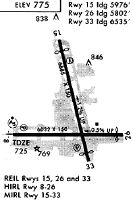
Runways
Runway Summary
| Runways: | 08/26 15/33 |
| Longest Runway: | 15/33 is 6886 ft (2099 m) long |
| Runways with an Instrument Approach: | 08 |
BUR Airport Runway Details
| Runway 08/26 | 5802 ft x 150 ft (1768 m x 46 m) | |
| Runway Length Source: | 3RD PARTY SURVEY as of 08/06/2017 | |
| Surface: | Asphalt/Concrete - Excellent condition - Saw-cut or plastic grooved | |
| Runway Pavement Class: | 58 /R/B/W/T | |
| Runway Edge Lights: | High Intensity | |
Runway Weight Bearing Capacity (in thousands of pounds) |
||
| Single Wheel Landing Gear: | 120.0 | |
| Dual Wheel Landing Gear: | 201.0 | |
| Dual Tandem Wheel Landing Gear: | 352.0 | |
| Dual Dual Tandem Wheel Landing Gear: | 839.0 | |
Runway 08 |
Runway 26 |
|
Elevation: |
727.4 | 697.3 |
Latitude: |
34-11-52.4794N | 34-11-51.5414N |
Longitude: |
118-22-08.9145W | 118-20-59.8557W |
|
Runway True Alignment: |
091 | 271 |
ILS Type: |
ILS | |
Glide Path Angle: |
3.0 degrees | 0.0 degrees |
Traffic Pattern: |
Right | Left |
Runway Markings Type: |
Precision Instrument | Nonprecision Instrument |
Runway Markings Condition: |
Good | Good |
Arresting Device: |
EMAS | |
Object at End: |
ROAD | POLE |
Object Height: |
14 | 40 |
Distance from End: |
300 | 245 |
Object Centerline Offset: |
0 ft. left and right of centerline | 410 ft. right of centerline |
Visual Glide Slope Indicators: |
4-Light PAPI On Left Side Of Runway | |
Runway Visual Range (RVR): |
Touchdown | Rollout |
Approach Light System: |
1,400 Foot Medium Intensity Approach Lighting System With Runway Alignment Indicator Lights | |
REIL: |
No | Yes |
Touchdown Lights: |
No | No |
Centerline Lights: |
No | No |
Threshold Crossing Height: |
72 | |
Declared Distances |
||
Take Off Run Avbl. (TORA): |
5801 | 5801 |
Take Off Distance Avbl. (TODA): |
5801 | 5801 |
Actual Stop Dist. Avbl. (ASDA): |
5801 | 5801 |
Landing Dist. Avbl. (LDA): |
5801 | 5801 |
| Runway 15/33 | 6886 ft x 150 ft (2099 m x 46 m) | |
| Runway Length Source: | 3RD PARTY SURVEY as of 08/06/2017 | |
| Surface: | Asphalt/Concrete - Excellent condition - Saw-cut or plastic grooved | |
| Runway Pavement Class: | 58 /R/B/W/T | |
| Runway Edge Lights: | Medium Intensity | |
Runway Weight Bearing Capacity (in thousands of pounds) |
||
| Single Wheel Landing Gear: | 120.0 | |
| Dual Wheel Landing Gear: | 201.0 | |
| Dual Tandem Wheel Landing Gear: | 352.0 | |
| Dual Dual Tandem Wheel Landing Gear: | 839.0 | |
Runway 15 |
Runway 33 |
|
Elevation: |
778.0 | 694.5 |
Latitude: |
34-12-44.4408N | 34-11-38.0587N |
Longitude: |
118-21-37.6586W | 118-21-19.3325W |
|
Runway True Alignment: |
167 | 347 |
Glide Path Angle: |
3.2 degrees | 3.2 degrees |
Traffic Pattern: |
Right | Left |
Runway Markings Type: |
Nonprecision Instrument | Nonprecision Instrument |
Runway Markings Condition: |
Good | Good |
Object at End: |
RR | POLE |
Object Height: |
30 | 31 |
Distance from End: |
200 | 201 |
Object Centerline Offset: |
0 ft. left and right of centerline | 410 ft. right of centerline |
Visual Glide Slope Indicators: |
4-Box VASI On Left Side Of Runway | 4-Light PAPI On Left Side Of Runway |
REIL: |
Yes | Yes |
Touchdown Lights: |
No | No |
Centerline Lights: |
No | No |
Threshold Crossing Height: |
34 | 62 |
Threshold Elevation: |
767.9 | 698.4 |
Displaced Threshold: |
909 | 350 |
Threshold Latitude: |
34-12-35.6750N | 34-11-41.4338N |
Threshold Longitude: |
118-21-35.2404W | 118-21-20.2640W |
Declared Distances |
||
Take Off Run Avbl. (TORA): |
6885 | 6885 |
Take Off Distance Avbl. (TODA): |
6885 | 6885 |
Actual Stop Dist. Avbl. (ASDA): |
6885 | 6885 |
Landing Dist. Avbl. (LDA): |
5976 | 6535 |
Services
Airframe Repair: |
Major |
Powerplant Repair: |
Major |
Bottled Oxygen: |
None |
Bulk Oxygen: |
None |
Fuel Available: |
100LL |
Landing Fees: |
No |
Parking: |
Tiedowns available |
Maps & Diagrams
BUR Sectional
Flight Planning
at skyvector.com
at skyvector.com