Location
Latitude: |
34-06-41.7940N (34.111609) |
Longitude: |
117-41-14.5980W (-117.687388) |
Elevation: |
1443.5 feet MSL (440 m MSL) |
Magnetic Variation: |
11.4 E (as of April 2024 from WMM2020 model) |
Time Zone: |
UTC -8.0 (Standard Time) UTC -7.0 (Daylight Savings Time) |
From City: |
02 N.M. NW of Upland, California |
Found On: |
Los Angeles Chart |
FAA Region: |
AWP |
Contacts
Manager: |
Privately owned: |
| STEPHEN DUNN 1749 WEST 13TH STREET UPLAND, CA 91786-2199 951-315-9224 |
CABLE LAND CO - A PARTNERSHIP 1749 WEST 13TH STREET UPLAND, CA 91786-2199 909-982-6021 |
Operations
Airport Status: |
Operational |
Facility Use: |
Public |
Type: |
Airport |
Activation Date: |
09/1945 |
Control tower: |
No |
Attendance (Months/Days/Hours): |
Months/Days/Hours ALL/ALL/DALGT |
Boundary ARTCC: |
ZLA (Los Angeles) |
Responsible ARTCC: |
ZLA (Los Angeles) |
Lighting Schedule: |
SEE RMK |
Segmented Circle Indicator: |
No |
Traffic Pattern Altitude (MSL): |
2444 feet (745 m) |
NOTAMs Facility: |
RAL |
NOTAM-D Service: |
Yes |
International Airport of Entry: |
No |
Customs Landing Rights: |
No |
Military Landing Rights: |
Yes |
Civil/Military Joint Use: |
No |
Based Aircraft
| Single Engine: | 222 |
| Multi Engine: | 12 |
| GA Helicopters: | 2 |
| Gliders: | 4 |
Annual Operations (as of 09/30/2019)
| Total Operations: | 92189 | |
| GA Local: | 73751 | 80.0% |
| GA Itinerant: | 18438 | 20.0% |
Communications
| CTAF: | 123.000 |
| Unicom: | 123.000 |
| Approach: | SOCAL 125.5 ;SW-NORTH 125.5 ;SW-NORTH |
| Departure: | SOCAL 125.5 ;SW-NORTH 125.5 ;SW-NORTH |
| AWOS-3P: | 119.525 (909-985-4731) |
Fixed Based Operators (FBOs) & Fuel
(Click on a business for detail)
Please help us keep this information up to date. This is a FREE SERVICE just like everything else on Airport Guide! If you see that a business needs to be added, modified, or deleted please fill out our Update Form.
To add, modify, or delete a business click here.
Please help us keep this information up to date. This is a FREE SERVICE just like everything else on Airport Guide! If you see that a business needs to be added, modified, or deleted please fill out our Update Form.
Area Code: 909 |
| Business Name | Frequency | Phone | Fuel Grade |
|---|---|---|---|
| Aircraft Interiors by Sill
Update FBO info |
981-4413 | ||
| Airport Management
Website Update FBO info |
Unicom 123.0 | 982-6021 | 80, 100LL |

|
Chevron |
80/87 - 2.40 USD per gallon on 9/10/01 |
24 Hour Self Serve Credit Card Pumps |
|
|
Chevron |
100LL - 2.40 USD per gallon on 9/10/01 |
24 Hour Self Serve Credit Card Pumps |
| Cable Air, Inc.
Update FBO info |
Unicom 123.0 | 982-1579 | |
| Foothill Aircraft
Update FBO info |
985-1977 | ||
| Pacific Coast Radio
Update FBO info |
920-5807 | ||
| Sky West Instruments
Update FBO info |
985-5718 | ||
| Sport Aerocolor
Update FBO info |
909-920-0460 |
Flight Service Stations
| Primary | Alternate | |
| FSS on Field: | N | |
| FSS Name (ID): | Riverside(RAL) | |
| Frequency: | ||
| Toll Free Phone: | 1-800-WX-BRIEF |
Instrument Procedures / Charts
FAA Terminal Procedures valid from 0901Z 03/21/24 to 0901Z 04/18/24.
There are various types of charts available for an airport. They are listed in the Page Type column. Here is a legend for those types:
APD - Airport Diagram
DP - Departure Procedure Charts
HOT - Hot Spots
IAP - Instrument Approach Procedure Charts
MIN - Minimums
STAR - Standard Terminal Arrival Charts
| Page Type | Page Name | Volume | Action Since Last Cycle |
|---|---|---|---|
| IAP | RNAV (GPS) RWY 06 | SW-3 | Changed |
| IAP | VOR-A | SW-3 | |
| MIN | TAKEOFF MINIMUMS | SW-3 |
Terminal Procedures are only available for airports in several countries with more being added all the time. If you are looking for a specific country's charts, please send an email to support(at)airportguide.com stating the country name. This will be used to prioritize the implementation.
Navigation Aids (Navaids) near CCB
| Dist (NM) | ID | Morse Code | Name | Type | Freq | True Hdg | Mag Hdg |
|---|---|---|---|---|---|---|---|
| 5.3 | POM | . _ _ . _ _ _ _ _ | Pomona | VORTAC | 110.40 | 248 | 237 |
| 14.0 | PDZ | . _ _ . _ . . _ _ . . | Paradise | VORTAC | 112.20 | 145 | 134 |
| 15.1 | RAL | . _ . . _ . _ . . | Riverside | VOR | 108.60 | 128 | 117 |
| 16.3 | SB | . . . _ . . . | Petis | NDB | 397 | 101 | 90 |
| 17.1 | EMT | . _ _ _ | El Monte | NDB | 359 | 265 | 254 |
| 23.9 | RIV | . _ . . . . . . _ | March | TACAN | 113.00 | 120 | 109 |
| 26.2 | ELB | . . _ . . _ . . . | El Toro | VOR-DME | 117.20 | 184 | 173 |
| 26.9 | SLI | . . . . _ . . . . | Seal Beach | VORTAC | 115.70 | 222 | 211 |
| 27.6 | SNA | . . . _ . . _ | Santa Ana | VOT | 110.00 | 199 | 188 |
| 28.8 | LG | . _ . . _ _ . | Becca | NDB | 233 | 222 | 211 |
| 30.9 | CPM | _ . _ . . _ _ . _ _ | Compton | NDB | 378 | 244 | 233 |
| 32.1 | HDF | . . . . _ . . . . _ . | Homeland | VOR | 112.05 | 128 | 117 |
| 32.5 | VCV | . . . _ _ . _ . . . . _ | Victorville | VOR-DME | 109.05 | 26 | 15 |
| 34.7 | UR | . . _ . _ . | Vinee | NDB | 253 | 278 | 267 |
| 36.3 | PMD | . _ _ . _ _ _ . . | Palmdale | VORTAC | 114.50 | 329 | 318 |
| 37.1 | PAI | . _ _ . . _ . . | Pacoima | NDB | 370 | 284 | 273 |
| 38.5 | LAX | . _ . . . _ _ . . _ | Los Angeles | VORTAC | 113.60 | 254 | 243 |
| 38.7 | SMO | . . . _ _ _ _ _ | Santa Monica | VOR-DME | 110.80 | 261 | 250 |
| 39.0 | LAX | . _ . . . _ _ . . _ | San Pedro Hill | VOT | 113.90 | 235 | 224 |
| 40.5 | VNY | . . . _ _ . _ . _ _ | Van Nuys | VOR-DME | 113.10 | 279 | 268 |
Nearby Airports with Fuel
Notices to Airmen (NOTAMS)
Remarks
| A110-1 | FOR CD CTC SOCAL APCH AT 800-448-3724. |
| A35-06/24 | GROSS PAVEMENT STRENGTH PRVDD BY ARPT OPERATOR 12500 LBS. |
| A43-24 | UNUSBL BYD 5 DEG LEFT AND 2 DEG RIGHT OF RWY CNTRLN. |
| A57-24 | APCH RATIO TO DSPLCD THR OVER +9 FT ROAD 220 FT FROM DSPLCD THR; 24:1. |
| A58-24 | +6 FT FENCE WITH RED LGTS 50 FT FROM THLD. |
| A70-FUEL-10 | 0LL SELF SERVICE 24 HOUR |
| A81-APT | ACTVT HELIPAD H1 PERIMETER LGTS - CTAF. MIRL RWY 06/24 PRESET ON LOW INTST SS-SR ACTVT HIGH INTST - CTAF. |
Runways
Runway Summary
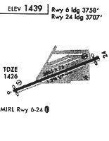
| Runways: | 06/24 H1 H2 |
| Longest Runway: | 06/24 is 3863 ft (1177 m) long |
| Runways with an Instrument Approach: |
CCB Airport Runway Details
| Runway 06/24 | 3863 ft x 75 ft (1177 m x 23 m) | |
| Runway Length Source: | 3RD PARTY SURVEY as of 09/25/2022 | |
| Surface: | Asphalt - Good condition - No special surface treatment | |
| Runway Edge Lights: | Medium Intensity | |
Runway Weight Bearing Capacity (in thousands of pounds) |
||
| Single Wheel Landing Gear: | 20.0 | |
Runway 06 |
Runway 24 |
|
Elevation: |
1393.0 | 1443.5 |
Latitude: |
34-06-34.9884N | 34-06-48.5983N |
Longitude: |
117-41-36.0586W | 117-40-53.1367W |
|
Runway True Alignment: |
069 | 249 |
Glide Path Angle: |
4.0 degrees | 4.0 degrees |
Traffic Pattern: |
Left | Left |
Runway Markings Type: |
Nonprecision Instrument | Basic |
Runway Markings Condition: |
Good | Good |
Object at End: |
ROAD | |
Object Height: |
9 | |
Distance from End: |
200 | |
Object Centerline Offset: |
0 ft. left and right of centerline | |
Visual Glide Slope Indicators: |
2-Box VASI On Left Side Of Runway | 2-Box VASI On Right Side Of Runway |
REIL: |
No | No |
Touchdown Lights: |
No | No |
Centerline Lights: |
No | No |
Threshold Crossing Height: |
34 | 24 |
Threshold Elevation: |
1393.3 | 1440.4 |
Displaced Threshold: |
106 | 157 |
Threshold Latitude: |
34-06-35.3609N | 34-06-48.0470N |
Threshold Longitude: |
117-41-34.8822W | 117-40-54.8766W |
| Helipad H1 | 65 ft x 65 ft (20 m x 20 m) | |
| Runway Length Source: | STATE as of 09/29/2006 | |
| Surface: | Asphalt - Good condition - No special surface treatment | |
| Runway Edge Lights: | Perimeter lights (for helipads) Intensity | |
Helipad H1 |
||
Glide Path Angle: |
0.0 degrees | 0.0 degrees |
Object Centerline Offset: |
0 ft. left and right of centerline |
| Helipad H2 | 65 ft x 65 ft (20 m x 20 m) | |
| Runway Length Source: | STATE as of 09/29/2006 | |
| Surface: | Asphalt - Good condition - No special surface treatment | |
Helipad H2 |
||
Glide Path Angle: |
0.0 degrees | 0.0 degrees |
Object Centerline Offset: |
0 ft. left and right of centerline |
Services
Airframe Repair: |
Major |
Powerplant Repair: |
Major |
Bottled Oxygen: |
None |
Bulk Oxygen: |
None |
Fuel Available: |
100LL, Jet A |
Landing Fees: |
No |
Parking: |
Tiedowns available |
Maps & Diagrams
CCB Sectional
Flight Planning
at skyvector.com
at skyvector.com